
Free USA map downloads
New Mexico ZIP Code Map
Download the free 3-digit map. Colour your own 5-digit map online.
A ready-made PDF with ZIP prefixes, highways and towns, or a more detailed map you can make your own. Choose the version that fits your job.
Go beyond the 3-digit overview
Need to colour individual
5-digit ZIP areas?
Open New Mexico in our map colouring tool. Pick your colours and click the ZIP areas to build a sales territory, delivery area or service coverage map.
- 281 mapped ZIP areas to colour
- Add your own map title and colour key
- Show or hide ZIP labels and place names
Try it before buying. Map access is needed to save and download your finished map.
Working across state borders? Combine neighbouring states →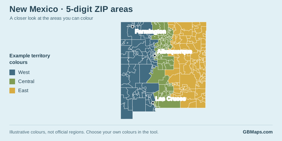
The free download
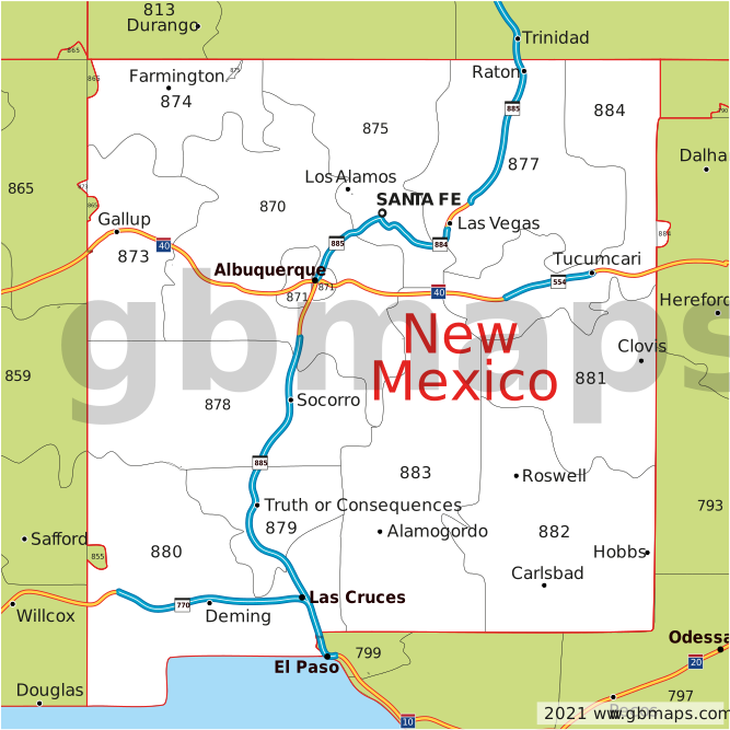
New Mexico 3-digit ZIP code map
A simple overview of ZIP prefixes, main highways, towns and cities.
 View larger
 Your free PDF is ready
Download a vector PDF for a clear, scalable map of New Mexico and its surroundings. It is useful for an overview in a document, a planning discussion or a printed reference.
Download FREE New Mexico PDFPDF · 3-digit ZIP prefixes · No colouring-tool account needed
Free PDF for your own use. Please retain the GBMaps copyright notice and check our map usage and copyright terms before publishing or redistributing artwork.
Need the editable artwork?
Get the supplied map files for your design work, with formats including PNG, PostScript, PowerPoint, SVG, EPS, PDF, Illustrator, JPG. Check the included files and current price before buying.
View New Mexico map files & price →This is the 3-digit artwork bundle, not access to the 5-digit colouring tool.
Or view the full-USA 3-digit artwork bundle →Choose the right level of detail
Mapping New Mexico
New Mexico stretches from the Four Corners area and northern mountain country to Albuquerque in the Rio Grande valley and Las Cruces farther south. Farmington provides a useful northwest reference point on a statewide map.
Use the PDF to show broad ZIP prefixes and roads. The five-digit tool can distinguish Albuquerque-area customers, a southern service patch or northwest coverage. Large rural polygons can span very different terrain, so the map is suitable for visual territory planning rather than calculating road access or visit times.
- Estimated residents
- 2,125,498US Census Bureau, 1 July 2025
- Square miles of land
- 121,312.75US Census Bureau, 2020 measurement
- Residents per square mile
- 17.5US Census Bureau, 2020 population density
- Mapped 5-digit ZIP areas
- 281Areas in our colouring-map dataset
| What you want to do | Best place to start |
|---|---|
| Download a ready-made ZIP and road overview | Free 3-digit PDF |
| Edit map artwork in a design package | 3-digit map-files bundle |
| Colour individual ZIP areas and add a key | 5-digit ZIP colouring tool |
| Make one territory map across state borders | Multi-state map chooser |
New Mexico ZIP map questions
Is the free New Mexico ZIP code map 3-digit or 5-digit?
The free PDF and the map preview show three-digit ZIP prefixes, main roads and place names. A prefix groups codes by their first three digits. To colour individual five-digit ZIP areas, open the separate New Mexico map in our online colouring tool.
Can I try the five-digit map before buying?
Yes. Load the map and try colouring areas, adding a key and changing the labels before buying access. Saving and downloading your finished map require the relevant map access. The free three-digit PDF download on this page is separate and does not require colouring-tool access.
Can I edit the map artwork?
The free PDF is a vector map for a clear view at different sizes. For supplied editable artwork and other formats, follow the editable-artwork section on this page. Check the available files and licence before buying; map files are separate from access to the online colouring tool.
Can I combine New Mexico with other states?
Yes. Open the state chooser and select up to three states that form a connected group. Each state must connect to the group, but does not have to touch every other selected state. Load and customise the combined map before buying. You can buy the selected states together, one state or access to all 50. Alaska may be added separately within the same three-state limit.
How should I prepare ZIP codes in a spreadsheet?
Keep the ZIP column as text with all five characters. Some US ZIP codes start with zero: for example, 02108 must not become 2108. Keeping the column as text prevents a spreadsheet from removing a leading zero before you import your codes into the colouring tool.
Are ZIP areas the same as counties or town boundaries?
No. ZIP codes are used for mail delivery; counties and municipalities are different geographies. Our colouring-tool dataset contains 281 mapped ZIP areas for New Mexico. That is a count of areas in this map, not a total of every USPS delivery code, PO Box or unique organisation code.
Need a hand? Read the guide to choosing and combining US states or talk to GBMaps.
Your areas. Your colours. Your New Mexico map.
Start with the five-digit map and make it your own.
Page content checked 30 September 2026 · About GBMaps · Facts are linked to their sources above.