Vector Editable Canadian Postal Code, Province and Country Map of Canada
Canada is split into 13 Provinces or Territories. The whole country has a postal code system which includes a forward sortation area and a local delivery unit. The Canadian forward sortation area is the first part of the postcode and comprises a letter, number and letter. This map contains the provinces of Canada boundaries along with the boundaries of each forward sortation area. These are all shown as simplified polygons and all can be edited, coloured and styled with software such as adobe Illustrator or Inkscape. The files are too complex to be edited with Microsoft publisher unfortunately.
3 Digit Canada Postcode Map including Major Towns, Cities and Provinces
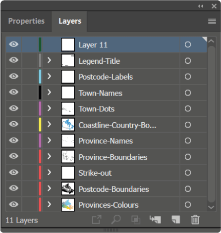
The Canadian vector postal codes map is fully layered so it’s possible to show and hide each layer independently of the others.
The provinces of each Canadian territory are labelled in editable text as are each of the forward sortation areas. The colours and styles of these labels can be changed easily.
Approximately 130 major towns and cities of Canada are on their own layer and can easily be edited, shown or hidden if required.
I would say this map wasn’t a ‘beginner’ map but with a good understanding of adobe illustrator it would be possible to create some really creative and useful maps of Canada. Sales territory mapping, planning of delivery charging areas or heatmap creation are all possibilities.
Delivered with this map bundle are the original Adobe Illustrator artwork, PDF files, EPS files, SVG files and Hi resolution JPG’s.

This map is vector editable which means it can be easily modified using Adobe Illustrator, Inkscape or other similar vector graphics editing packages.
($74 can. dollars)
(includes 7 file types)
Editable Canada Vector Map Download
Just a small sample area of the canadian postal zones map showing forward sortation areas.

Below you can see the layer structure of the adobe illustrator vector postcode map file.
