February 2022 UK NHS Health Boards & CCG’s inc. England, Northern Ireland, Scotland & Wales CCG’s covered
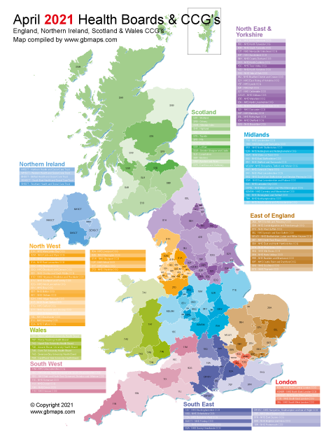
We've compiled a full NHS UK Vector Map consisting of the English CCG's, Scottish Health Boards, Northern Ireland Social Care Trusts and the Welsh University Health Boards - February 2022 Version.
This is a unique map with all areas seperated onto different layers and grouped into the correct regions. Scotland is all one region England is made up of the 7 main CCG regions while Wales and Northern Ireland are grouped into their respective regions. If editing this map in adobe illustrator it is possible to show or hide any of the regions, countries or areas easily and it's also very easy to identify individual trusts in order to group them into your own territories.
Not seen on Health Board or Clinical Commissioning Group(CCG) Maps very often we have amalgamated the NHS regions of the United Kingdom including England, Northern Ireland, Scotland and Wales into one map. The map comes in vector based file formats which means it can be blown up to extra large sizes for printing without losing any resolution and can be zoomed in to view in crisp detail.
The original Illustrator artwork is included in the files bundle so the map can be edited. We’ve also included an NHS CCG Powerpoint version of the map which is great for editing from within powerpoint. Everything you see in the map below is included on all the files within the download of this map.
The new 5 London Clinical Commissioning Group boundaries have been blown up to appear as it’s own inset map at the side of the main map. Each group is labelled with the corresponding CCG code and the full name of the CCG is listed in colour coordinated table above the map. London has quite small boundaries where the labels can be difficult to read so this enlarged CCG London inset map is a great addition.
We can also supply the GIS .SHP shapefiles of all the clinical commissioning groups(CCG’s), University Trusts and Health Boards shown on the Full UK CCG map(seen on the left) as one integrated set of GIS files.
The tables seen on the map sample don’t exist in shapefiles(as you will know) and special software such as QGIS or ArcGIS or equivalent is required to view and edit the files.
The GIS & database files containing all the attributes of each region, group and trust are NOT included in this bundle.
Customise our NHS Maps Online here:
Call or message us today to talk about your bespoke projects. Tel 01751 473136 or Contact Form
There are 5 Individual Health and Social Care Trusts (HSCT’s) in Northern Ireland which are included on the map as individual editable polygons.
The 7 Welsh University Health Boards boundaries are shown as individual adjacent editable polygons with their corresponding 3 letter code.
The 14 regional Scottish Health Boards are shown on the map and labelled with the name of the board and the corresponding 3 digit code.
After the latest adjustments to the boundaries in February 2022 there are 135 Clinical Commissioning Groups in England. All of the polygons are labelled with the 3 digit code of the CCG and in the table by the side of the map is the actual name of the CCG along with the 3 letter code.
Vector map image file formats are far better and more versatile than normal images when it comes to mapping. Raster image files are files with extensions such as .jpg, .gif, .png etc. Vector files are more like coloured drawings where every line, shape or piece of text is created using coordinates and attributes that make up complex images with code which can be edited after the image has been created. A vector map can be opened in applications such as Adobe Illustrator, Inkscape, Corel, Powerpoint and many other editing packages(some of which are free to download and use). The other major benefit of a vector file format is they can be scaled up to any size and they don’t become pixelated or lose any resolution. You could literally print it out the size of a bus and it would be as crisp as if it were printed at A4.
We can also supply A0 Laminated Prints of our Clinical Commissioning Group (CCG) Health Board Maps.
We can print any of our maps at almost any size. If you need a laminated poster map, A4 printed maps, deskpads or something for the office wall including maps printed onto a whiteboard or magnetic board then we can help. We can create the maps you need and transfer them onto all kinds of printed media, faster and for a lot less cost than you might originally think.
Call or message us today to talk about your project. Tel 01751 473136 or Contact Form