
Free USA county map downloads
Texas County Map — Free Vector PDF
County boundaries, highways, towns and cities. Ready to download.
Get a ready-made Texas map, or colour your own counties online. Add place names and dots, or combine touching states into one county map.
Make the map your own
Turn counties into your own territories
Choose a colour, click the counties you cover and add a key. Build a clear picture of sales territories, service areas or regional teams in our online map colouring tool.
- Colour individual counties or groups of areas
- Add your own map title and colour key
- Try your map before buying access
Opens the Texas county map directly. Map access is needed to save and download your finished map.
Just want the ready-made map? Download the free PDF ↓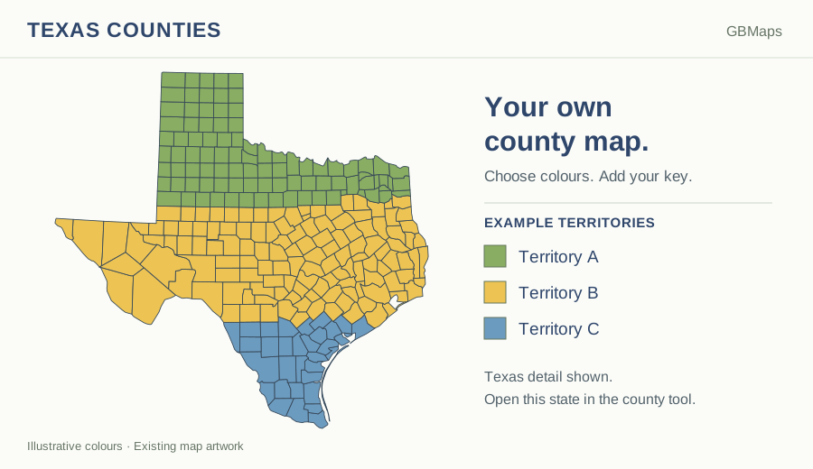
The free download
Texas County Map
A vector PDF with county outlines, main highways, towns and cities.
 View larger
 Your free PDF is ready
Use this ready-made map for a regional overview, a planning discussion or a printed reference. The vector artwork stays clear as you zoom in.
Download FREE Texas PDFPDF · County boundaries, roads and places · No account needed
Please retain the GBMaps copyright notice and check our map usage and copyright terms before publishing or redistributing artwork.
Need the editable artwork?
Get the supplied map files for design work. Available formats include PNG, PostScript, PowerPoint, SVG, EPS, PDF, Illustrator and JPG. Check the included files, current price and licence before buying.
View Texas map files & price →This is an artwork-file bundle, not access to the online colouring tool.
Or view the full-USA county artwork bundle →County territories across state lines
Build a multi-state county map
Choose up to three touching states on the USA chooser map. Load them together, colour the counties and use one title and key. Alaska can be added as a separate inset.
Choose states to combine →Try before buying. One state is £25 + VAT; buy selected states together, or unlock all 50 state county maps for £150 + VAT for 12 months. County access and ZIP-map access are separate products.
Places and county names
Show or hide county names, cities, towns and villages in Map details. Place names and dots are kept together and automatically thinned out where space is tight. Choose their colours to suit your map.
The new online state maps use Census 2025 county and equivalent boundaries. Connecticut uses its nine planning regions. The ready-made free artwork retains its original boundaries, as explained below.
Choose the right level of detail
Mapping Texas by county
Texas has a large number of counties, so grouping neighbouring areas into clear territories is often more helpful than colouring each one differently. Use the county overview to explain statewide responsibility, then switch to ZIP areas for a local delivery or customer map.
Brewster County and Pecos County are among Texas’s largest county-level areas by land area in the 2025 Census Gazetteer. A county-wide allocation can therefore be much broader than a local customer patch. Add town and city names to give your county territories local context.
- Counties
- 254US Census Bureau, 2025 Gazetteer
- Estimated residents
- 31,709,821US Census Bureau, 1 July 2025
- Square miles of land
- 261,267.85US Census Bureau, 2020 measurement
- Mapped 5-digit ZIP areas
- 1,729Areas in our separate ZIP colouring map
| What you want to do | Best place to start |
|---|---|
| Download a ready-made county and road map | Free county PDF |
| Edit the map in a design package | Texas artwork bundle |
| Colour counties and add my own key | Texas county colouring tool |
| Combine counties across state lines | Choose touching states |
Texas county names and reference list
Alphabetical reference list from the 2025 Gazetteer. Names and boundaries in older artwork may differ; this list is not a claim that the original map has been redrawn. Source: US Census Bureau, 2025 Gazetteer.
- Anderson County
- Andrews County
- Angelina County
- Aransas County
- Archer County
- Armstrong County
- Atascosa County
- Austin County
- Bailey County
- Bandera County
- Bastrop County
- Baylor County
- Bee County
- Bell County
- Bexar County
- Blanco County
- Borden County
- Bosque County
- Bowie County
- Brazoria County
- Brazos County
- Brewster County
- Briscoe County
- Brooks County
- Brown County
- Burleson County
- Burnet County
- Caldwell County
- Calhoun County
- Callahan County
- Cameron County
- Camp County
- Carson County
- Cass County
- Castro County
- Chambers County
- Cherokee County
- Childress County
- Clay County
- Cochran County
- Coke County
- Coleman County
- Collin County
- Collingsworth County
- Colorado County
- Comal County
- Comanche County
- Concho County
- Cooke County
- Coryell County
- Cottle County
- Crane County
- Crockett County
- Crosby County
- Culberson County
- Dallam County
- Dallas County
- Dawson County
- Deaf Smith County
- Delta County
- Denton County
- DeWitt County
- Dickens County
- Dimmit County
- Donley County
- Duval County
- Eastland County
- Ector County
- Edwards County
- El Paso County
- Ellis County
- Erath County
- Falls County
- Fannin County
- Fayette County
- Fisher County
- Floyd County
- Foard County
- Fort Bend County
- Franklin County
- Freestone County
- Frio County
- Gaines County
- Galveston County
- Garza County
- Gillespie County
- Glasscock County
- Goliad County
- Gonzales County
- Gray County
- Grayson County
- Gregg County
- Grimes County
- Guadalupe County
- Hale County
- Hall County
- Hamilton County
- Hansford County
- Hardeman County
- Hardin County
- Harris County
- Harrison County
- Hartley County
- Haskell County
- Hays County
- Hemphill County
- Henderson County
- Hidalgo County
- Hill County
- Hockley County
- Hood County
- Hopkins County
- Houston County
- Howard County
- Hudspeth County
- Hunt County
- Hutchinson County
- Irion County
- Jack County
- Jackson County
- Jasper County
- Jeff Davis County
- Jefferson County
- Jim Hogg County
- Jim Wells County
- Johnson County
- Jones County
- Karnes County
- Kaufman County
- Kendall County
- Kenedy County
- Kent County
- Kerr County
- Kimble County
- King County
- Kinney County
- Kleberg County
- Knox County
- La Salle County
- Lamar County
- Lamb County
- Lampasas County
- Lavaca County
- Lee County
- Leon County
- Liberty County
- Limestone County
- Lipscomb County
- Live Oak County
- Llano County
- Loving County
- Lubbock County
- Lynn County
- Madison County
- Marion County
- Martin County
- Mason County
- Matagorda County
- Maverick County
- McCulloch County
- McLennan County
- McMullen County
- Medina County
- Menard County
- Midland County
- Milam County
- Mills County
- Mitchell County
- Montague County
- Montgomery County
- Moore County
- Morris County
- Motley County
- Nacogdoches County
- Navarro County
- Newton County
- Nolan County
- Nueces County
- Ochiltree County
- Oldham County
- Orange County
- Palo Pinto County
- Panola County
- Parker County
- Parmer County
- Pecos County
- Polk County
- Potter County
- Presidio County
- Rains County
- Randall County
- Reagan County
- Real County
- Red River County
- Reeves County
- Refugio County
- Roberts County
- Robertson County
- Rockwall County
- Runnels County
- Rusk County
- Sabine County
- San Augustine County
- San Jacinto County
- San Patricio County
- San Saba County
- Schleicher County
- Scurry County
- Shackelford County
- Shelby County
- Sherman County
- Smith County
- Somervell County
- Starr County
- Stephens County
- Sterling County
- Stonewall County
- Sutton County
- Swisher County
- Tarrant County
- Taylor County
- Terrell County
- Terry County
- Throckmorton County
- Titus County
- Tom Green County
- Travis County
- Trinity County
- Tyler County
- Upshur County
- Upton County
- Uvalde County
- Val Verde County
- Van Zandt County
- Victoria County
- Walker County
- Waller County
- Ward County
- Washington County
- Webb County
- Wharton County
- Wheeler County
- Wichita County
- Wilbarger County
- Willacy County
- Williamson County
- Wilson County
- Winkler County
- Wise County
- Wood County
- Yoakum County
- Young County
- Zapata County
- Zavala County
Texas county map questions
How do I download the free Texas county map?
Use the green Download FREE PDF button on this page. No colouring-tool account is needed. The vector PDF includes county outlines, main highways, towns and cities. You can enlarge the preview first to check the detail.
How many counties does Texas have?
Texas has 254 counties in the 2025 Census Gazetteer. The alphabetical reference list below uses that source, not a new survey of the boundaries in the older map artwork. County, city and ZIP boundaries are different geographies.
Can I colour the counties and add my own key?
Yes. Open this state’s county colouring tool, choose a colour and click the counties you want to include. Add your own title and colour key to explain your sales territories, service coverage or other groups. The link opens this state on its own. You can also combine up to three touching states, with Alaska as the separate-inset exception.
Can I try the colouring tool before buying?
Yes. Load the county map and try colouring it and adding a key before buying access. Saving and downloading your finished map require the relevant map access. The free PDF on this page is a separate ready-made download.
Is the free PDF the same as the editable artwork bundle?
No. The free PDF is a ready-made vector map. The map-files purchase supplies a bundle of artwork formats for design work; follow the map-files link to check the included formats, current price and licence. Buying artwork files is separate from buying access to the online colouring tool.
What does access to the county maps cost?
One state costs £25 + VAT for 12 months. Buy your selected states together, or choose all 50 state county maps for £150 + VAT. Existing state access is excluded from the selected-state price. You can load and customise maps in trial mode before buying.
Can I use these maps for navigation or legal boundary checks?
No. These are visual reference and planning maps, not navigation, surveying or legal boundary records. A copyright year does not identify the date of the underlying boundaries. Check an authoritative source for decisions that depend on an exact boundary, or ask GBMaps about a particular area.
Need a hand? Read the map colouring help or talk to GBMaps.
Your counties. Your colours. Your map.
Show the areas that matter to your business.
Page content checked 1 October 2026 · About GBMaps · Facts are linked to their sources above.