European 2-Digit Postcode Map Download in Digital Vector Editable File Formats. All European Countries Covered and More.
European 2-Digit Postcode Map Download in Digital Vector Editable File Formats. All European Countries Covered and More.

Who are the Europe Postcode Map Files suitable for?
Graphic designers, cartography people and illustrators. The map comes as a zipped folder with various vector editable file formats included. The Layered Adobe Illustrator Europe Map is the most useful of the files included. Every single object can be edited including changing the fill colours, stroke colours, font family, font size or colour and visibility of any object. The map is very complicated with many vertices and will need a decent specification computer to work with efficiently. You should also have a basic understanding of Adobe Illustrator or Inkscape in order to edit the maps. If you require this European postcode map customising in any way or you require it printed, please get in touch.
 Files Included in the download
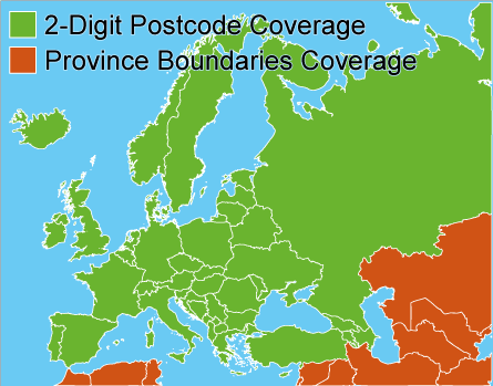
We’ve taken a small section of our whole European postcode map and cropped it to provide you with a sample download. You can see the layer structure and level of detail in the sample download if opened with Adobe Illustrator or Inkscape. We’ve included a PDF and EPS file in the download along with the illustrator file. The download will begin automatically and is approximately 4mb in size.

Some of the countries in Europe have dubious postal code systems in place. We've spent a lot of time to make this map as accurate as possible however there maybe some small inaccuracies we don't know about.
There are many sub-layers to each of the top-level layers shown in the panel below. There are too many to show in this image however they are all present and correct in the free vector map download(opposite). Our downloads are totally secure and virus and malware free however if you would prefer us to email you a sample then please get in touch and we'll be happy to help.

European Postcode Map Illustrator CC 2018 - Layers Panel
Why is our map better than the others?
We have painstakingly created this map from many different sources. We haven’t found any other 2-digit postcode map of Europe that goes down to 2 digits for ALL the countries of Europe. Other maps cover the more widely known countries but not some of the smaller ones where single digits prefixed with a zero have been used instead. Our map is different because where there are genuine 2-digit postcodes to be found, we have found them. We’ve recreated the boundaries and projected them to the World Mercator Map Projection then incorporated them into our map.
Some of the data is very rare and has been sourced by us from people local to that country and redrawn and labelled to the correct map projection.
Licensing
This is simple. Don’t re-sell the data in any form unless you’ve got permission first. Don’t make it freely available for people to download or obtain in a vector file format(e.g. PDF) without permission. If displaying sections of the map online as raster images, please ensure that www.gbmaps.com is visible in small but readable text in either corner of the image. If printing the map largescale, please ensure www.gbmaps.com is visible in readable text somewhere in the corner of the map. If in any doubt please get in touch as we’re very amenable and in 99% of cases give you permission to use the map how you want.
Disclaimer
While we have made exhaustive efforts to ensure the data shown on this map is correct, there may be occasions where it has not been possible to accurately confirm a postal codes existence and assumptions have ben made. We don’t believe the map is incorrect however if we’re told about a mistake then we will immediately amend and correct the map and re-issue it.
If you don’t need the whole of Europe you can purchase individual countries at 2 digit postal code level. Precisely the same detail as the full Europe Map with the same file formats included and the same licensing.
N.B.
We can also supply this map in a printed format as an A0(1189mm x 841mm), glossy laminated/encapsulated print.