Various different UK Health Boundaries. Including the latest ICB, APC, ICS boundary data from the NHS and Government.

Call Us Now for Help

01751 473136

NHS Integrated Care Board Maps (ICB Maps)

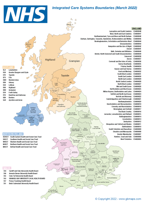
Integrated care boards (ICBs) replaced clinical commissioning groups (CCGs) in the NHS in England from 1 July 2022. Our Integrated Car Board map shows the boundaries in England as they are defined by the NHS.  There are 42 ICB’s and they are all defined accurately on in vector based maps.  You can either download a small bundle of digital files for use in Adobe Illustrator, Inkscape Powerpoint and other applications or you can use our Online Map Colouring Tool to customise your own maps and then download them as vector pdf files.

nhs integrated care board map

NHS Integrated Care Systems Maps (ICS Maps)

Integrated Care Systems are very similar to Integrated Care Boards with a few small changes.  Mainly where a small number of ICB’s have been split into 2 or more ICS’s. If you need an ICS map rather than an ICB map, you know what you need. Our ICS maps are delivered in the same file formats as our ICB maps and can also be customised using our online map customization tools. We’d advise giving our online tools a try-out before buying and downloading the editable files. We developed the tool to erradicate the need form alternative editing software.

integrated care systems ics map

We've built an online mapping tool for you to customise our NHS Boundary Maps Online here:

Call or message us today to talk about your bespoke projects. Tel 01751 473136 or Contact Form

Area Prescribing Committee Maps (APC Maps)

Area Prescribing Committee (APC) boundaries in England are sometimes called Medicines Optimisation Committees(MOCs). We’re not in the medical industry so don’t fully understand the way the NHS does things, but we are experts when it comes to maps and mapping data. We created this map using vector polygons and regular text labels. As a download you receive a small bundle of original vector and raster editable files. Use Adobe Illustrator, PowerPoint or InkScape (or similar) software to edit these maps.  If you don’t have an editing software available then try our map colouring and customization tools. We developed theses tools over the last ten years specifically for people that don’t have access to professional graphics editing or mapping software.

area prescribing committee
The above is a raster snapshot table taken from the actual vector map.

Primary Care Network Maps (PCN Maps)

We believe this is the only map available that shows all 1,250 PCN boundaries in the UK. It is only useful for statistical and graphical purposes and not for geographical planning.  We created this map by clustering all the suppliers that make up each PCN, then creating a centroid for each of those clusters. This provided us with 1,250 PCN centroids but no boundaries.  We then ran some fancy mapping algorithms to produce a polygon map to cover the whole of England. We then labelled and produce the final vector artwork, exported numerous file formats and that’s the bundle you receive.  It will be available in our map colouring tool suite soon.

primary care network boundary map
Above is a raster screenshot taken from the actual vector editable map.

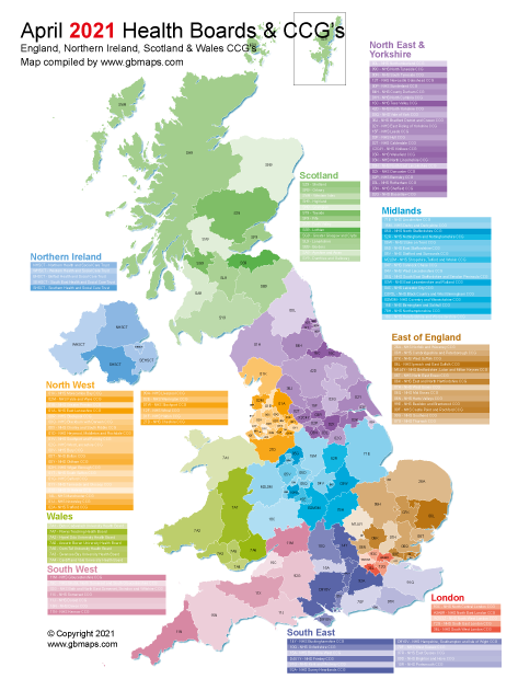
Health Boards & CCG Maps. (replaced with ICB's & ICS's)

There are 5 Individual Health and Social Care Trusts (HSCT’s) in Northern Ireland which are included on the map as individual editable polygons.
The 7 Welsh University Health Boards boundaries are shown as individual adjacent editable polygons with their corresponding 3 letter code.
The 14 regional Scottish Health Boards are shown on the map and labelled with the name of the board and the corresponding 3 digit code.
After the latest adjustments to the boundaries in February 2022 there are 135 Clinical Commissioning Groups in England. All of the polygons are labelled with the 3 digit code of the CCG and in the table by the side of the map is the actual name of the CCG along with the 3 letter code.

uk nhs ccg map
The above is a snapshot table taken from the actual map.

A0 (841mm x 1189mm) Glossy laminated Map Prints

Nearly all our maps are bespoke and custom designed however clients sometimes need an off-the-shelf map print for their wall.  The most popular map we supply in a physical form is a glossy laminated (encapsulated back and front) A0(A-zero) 841mm x 1189mm Portrait format.  We use the same specialist printing company we’ve used for over 10 years and will guarantee the quality of the printing and laminating. We can do other sizes but these depend on the level of detail shown on the map.  The more detail the larger the print needed.  Our A0 glossy laminated prints cost £60.00(zero vat). The artwork or type of map you need printing on the map is priced separately.

encapsulated map print rolled
Photo of the corner of a laminated/encapsulated map.
POSTERS - Printed on high quality 180gsm paper then glossy laminated/encapsulated front and back. Delivered rolled in a tube.
 
  Laminated Non-Laminated Poster Prints
Size Cost Cost
A3 £24.00 £9.90
A2 £35.00 £14.30
A1 £46.00 £30.28
A0 £62.50 £44.00
     
 
£6 single additional charge per delivery address.

Call or message us today to talk about your project. Tel 01751 473136 or Contact Form