FREE NHS ICB MAPS · EAST OF ENGLAND
Central East ICB map
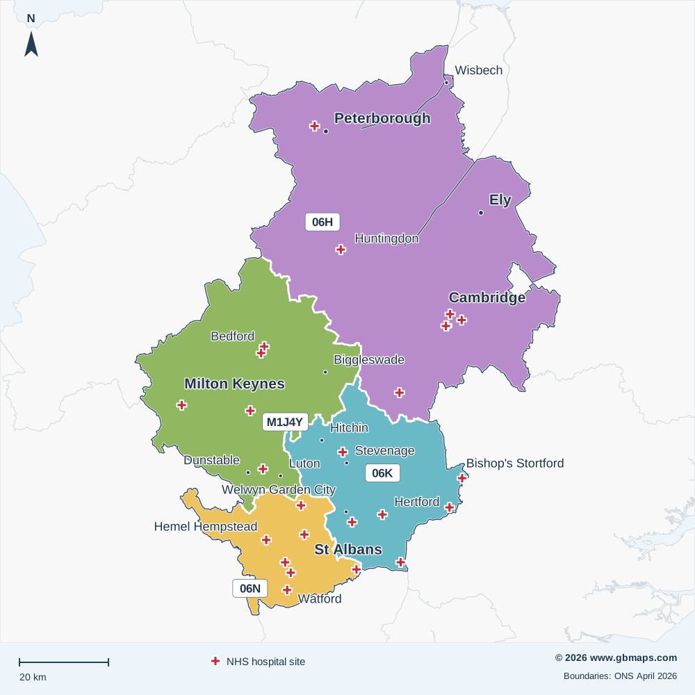
Explore the Central East ICB map, including Cambridge, Peterborough, Milton Keynes and St Albans. View the April 2026 boundary, local Sub-ICB areas and NHS hospital locations, or download the free vector PDF.
Established in April 2026 from all or parts of the former ICB areas listed below.
Bedfordshire, Luton and Milton Keynes ICB · Cambridgeshire and Peterborough ICB · Hertfordshire and West Essex ICB
Inside Central East ICB
The Central East Integrated Care Board (ICB) boundary covers approximately 6,643 km² in the East of England NHS region, extending roughly 128 km north to south and 96 km east to west.
Its 4 Sub-ICB locations show the local divisions within the ICB. The checked hospital directory includes 26 NHS trust or care-trust sites within the outline. The primary care extract records 76 PCNs associated with this ICB and 265 distinct GP practice codes.
Postal coverage reaches into 139 postcode districts and 499 postcode sectors. PE28, MK45, PE7, PE19, MK42 have the largest numbers of current postcode locations allocated to this ICB in the dataset. Explore the main postcode areas, NHS hospitals and local street maps below.
- Mapped area
- 6,643 km²
- Sub-ICB areas
- 4
- NHS hospital records
- 26
- Primary care networks
- 76
Explore other free ICB maps
36 current ICBsPrevious ICB areas Before April 2026
NHS hospitals on the map
26 named NHS trust or care-trust hospital records are shown. Private operators are excluded; sites sharing a location may have a single cross.
View the NHS hospital names and postcodes 26
- Addenbrooke'sCB2 0QQ
- Bedford Hospital North WingMK40 2NS
- Bedford Hospital South WingMK42 9DJ
- Brookfields HospitalCB1 3DF
- Capio Rivers HospitalCM21 0HH
- Cheshunt Community HospitalEN8 8XN
- Fulbourn HospitalCB21 5EF
- Harpenden Memorial HospitalAL5 4TA
- Hemel Hempstead HospitalHP2 4AD
- Hertford County HospitalSG14 1LP
- Herts & Essex HospitalCM23 5JH
- Hinchingbrooke HospitalPE29 6NT
- Langley House Community HospitalWD25 9FG
- Lister HospitalSG1 4AB
- Luton and Dunstable HospitalLU4 0DZ
- Milton Keynes HospitalMK6 5LD
- New QEII HospitalAL7 4HQ
- Peterborough City HospitalPE3 9GZ
- Potters Bar Community HospitalEN6 2RY
- Rosie HospitalCB2 0QQ
- Royal Papworth HospitalCB2 0AY
- Royston HospitalSG8 9EN
- St Albans City HospitalAL3 5PN
- Steppingley HospitalMK45 1AB
- Watford General HospitalWD18 0HB
- West Hertfordshire Hospitals Therapy UnitWD5 0PA

MAKE THE MAP YOUR OWN
Colour and customise your ICB map
Highlight ICB areas, add place markers and labels, and build a map key for your report or presentation.
See the map assistant add a hospital marker and coloured drive-time areas in this example.
Open the ICB colouring toolMap sources and useful limits
Boundaries: ONS ICB and Sub-ICB locations, April 2026. Outlines are simplified for display; place and postcode matches use the original boundaries.
Hospital names come from the supplied hospital directory, matched to active NHS Organisation Data Service records on 13 November 2026. Only sites associated with NHS trusts or care trusts are included. This is a selection of hospital locations, not a list of current clinical services or commissioning relationships.
PCN count: the supplied 2026 primary care extract. Main postcode areas: the six largest areas with at least 2% of the ICB’s located current postcodes in the November 2026 dataset. A postcode area name does not mean its namesake town is inside the ICB.
Place names: Ordnance Survey. Contains OS data © Crown copyright and database right 2026. Contains Royal Mail data © Royal Mail copyright and database right 2026. Contains National Statistics data © Crown copyright and database right 2026. Map artwork © GBMaps.com.