FREE NHS ICB MAPS · NORTH EAST AND YORKSHIRE
North East and North Cumbria ICB map
Explore the North East and North Cumbria ICB map, including Newcastle upon Tyne, Sunderland, Durham and Carlisle. View the April 2026 boundary, local Sub-ICB areas and NHS hospital locations, or download the free vector PDF.
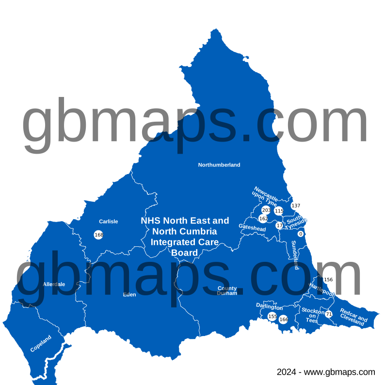
Inside North East and North Cumbria ICB
The North East and North Cumbria Integrated Care Board (ICB) boundary covers approximately 13,642 km² in the North East and Yorkshire NHS region, extending roughly 171 km north to south and 184 km east to west.
Its 8 Sub-ICB locations show the local divisions within the ICB. The checked hospital directory includes 55 NHS trust or care-trust sites within the outline. The primary care extract records 67 PCNs associated with this ICB and 338 distinct GP practice codes.
Postal coverage reaches into 162 postcode districts and 535 postcode sectors. NE61, DL1, DH8, DH1, CA14 have the largest numbers of current postcode locations allocated to this ICB in the dataset. Explore the main postcode areas, NHS hospitals and local street maps below.
- Mapped area
- 13,642 km²
- Sub-ICB areas
- 8
- NHS hospital records
- 55
- Primary care networks
- 67
Explore other free ICB maps
36 current ICBsPrevious ICB areas Before April 2026
NHS hospitals on the map
55 named NHS trust or care-trust hospital records are shown. Private operators are excluded; sites sharing a location may have a single cross.
View the NHS hospital names and postcodes 55
- Alston (Ruth Lancaster James) Community HospitalCA9 3QT
- Auckland Park Hospital, Bishop AucklandDL14 6AE
- Bensham HospitalNE8 4YL
- Berwick InfirmaryTD15 1LT
- Bishop Auckland HospitalDL14 6AD
- Blyth Community HospitalNE24 1DX
- Chester Le Street HospitalDH3 3AT
- Cockermouth Community HospitalCA13 9HT
- Cumberland InfirmaryCA2 7HY
- Darlington Memorial HospitalDL3 6HX
- Durham Community HospitalDH1 5AJ
- East Cleveland HospitalTS12 2FF
- FerndeneNE42 5PB
- Freeman HospitalNE7 7DN
- Guisborough General HospitalTS14 6HZ
- Haltwhistle War Memorial HospitalNE49 9AJ
- Hexham General HospitalNE46 1QJ
- Horn Hall HospitalDL13 2JR
- Hundens Lane Day Hospital - DarlingtonDL1 1JE
- Keswick (Mary Hewetson) Community HospitalCA12 5PH
- Maryport Victoria Cottage HospitalCA15 8EJ
- Monkton Hall HospitalNE32 5NN
- Monkwearmouth HospitalSR5 1NB
- Morpeth Cottage HospitalNE61 2BT
- New Richardson HospitalDL12 8HT
- Newcastle Dental HospitalNE2 4AZ
- Newcastle Hospitals @ CramlingtonNE23 6UL
- North Tyneside General HospitalNE29 8NH
- Northumbria Healthcare NHS Foundation TrustNE27 0QJ
- Northumbria Specialist Emergency Care HospitalNE23 6NZ
- Palmer Community HospitalNE32 3UX
- Penrith HospitalCA11 8HX
- Primrose Hill HospitalNE32 5HA
- Queen Elizabeth HospitalNE9 6SX
- Redcar Primary Care HospitalTS10 4NW
- Roseberry Park HospitalTS4 3AF
- Rothbury Community HospitalNE65 7RW
- Sedgefield Community HospitalTS21 3EE
- Shotley Bridge HospitalDH8 0NB
- South Tyneside District HospitalNE34 0PL
- St George's ParkNE61 2NU
- St Nicholas HospitalNE3 3XT
- Tees, Esk, Wear Valley NHS Trust (Durham)DL2 2TS
- The James Cook University HospitalTS4 3BW
- The Royal Victoria InfirmaryNE1 4LP
- University Hospital Of HartlepoolTS24 9AH
- University Hospital Of North DurhamDH1 5TW
- University Hospital Of North TeesTS19 8PE
- Walkergate ParkNE6 4QD
- Wansbeck General HospitalNE63 9JJ
- Weardale HospitalDL13 2JR
- West Cumberland HospitalCA28 8JG
- West Lane Hospital, MiddlesbroughTS5 4EE
- West Park Hospital, DarlingtonDL2 2TS
- Wigton Community HospitalCA7 9DD

MAKE THE MAP YOUR OWN
Colour and customise your ICB map
Highlight ICB areas, add place markers and labels, and build a map key for your report or presentation.
See the map assistant add a hospital marker and coloured drive-time areas in this example.
Open the ICB colouring toolMap sources and useful limits
Boundaries: ONS ICB and Sub-ICB locations, April 2026. Outlines are simplified for display; place and postcode matches use the original boundaries.
Hospital names come from the supplied hospital directory, matched to active NHS Organisation Data Service records on 13 November 2026. Only sites associated with NHS trusts or care trusts are included. This is a selection of hospital locations, not a list of current clinical services or commissioning relationships.
PCN count: the supplied 2026 primary care extract. Main postcode areas: the six largest areas with at least 2% of the ICB’s located current postcodes in the November 2026 dataset. A postcode area name does not mean its namesake town is inside the ICB.
Place names: Ordnance Survey. Contains OS data © Crown copyright and database right 2026. Contains Royal Mail data © Royal Mail copyright and database right 2026. Contains National Statistics data © Crown copyright and database right 2026. Map artwork © GBMaps.com.