FREE NHS ICB MAPS · EAST OF ENGLAND
Norfolk and Suffolk ICB map
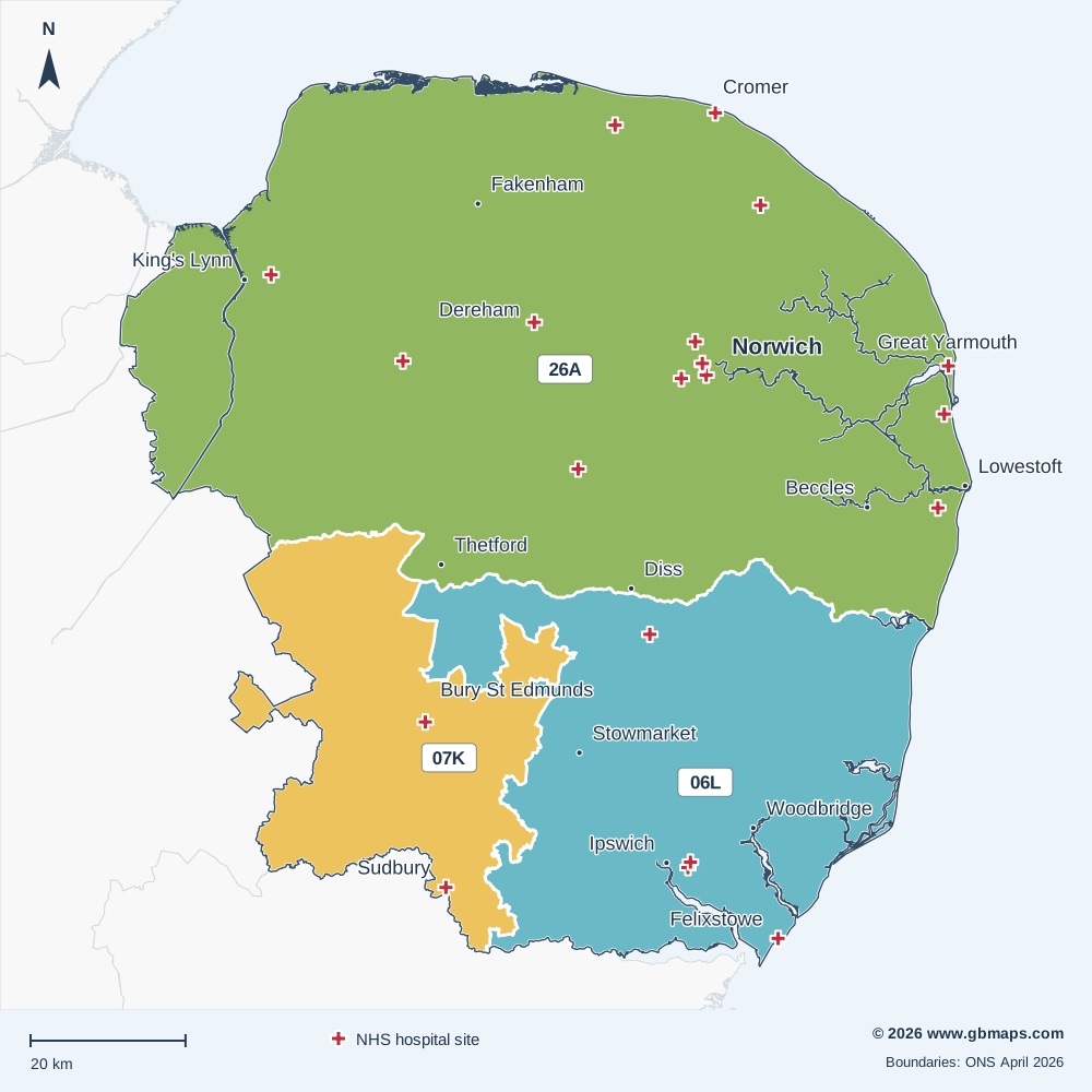
Explore the Norfolk and Suffolk ICB map, including Norwich, Ipswich, Great Yarmouth and Lowestoft. View the April 2026 boundary, local Sub-ICB areas and NHS hospital locations, or download the free vector PDF.
Established in April 2026 from all or parts of the former ICB areas listed below.
Inside Norfolk and Suffolk ICB
The Norfolk and Suffolk Integrated Care Board (ICB) boundary covers approximately 9,185 km² in the East of England NHS region, extending roughly 116 km north to south and 110 km east to west.
Its 3 Sub-ICB locations show the local divisions within the ICB. The checked hospital directory includes 22 NHS trust or care-trust sites within the outline. The primary care extract records 35 PCNs associated with this ICB and 162 distinct GP practice codes.
Postal coverage reaches into 90 postcode districts and 285 postcode sectors. IP14, CO10, PE30, NR31, IP13 have the largest numbers of current postcode locations allocated to this ICB in the dataset. Explore the main postcode areas, NHS hospitals and local street maps below.
- Mapped area
- 9,185 km²
- Sub-ICB areas
- 3
- NHS hospital records
- 22
- Primary care networks
- 35
Explore other free ICB maps
36 current ICBsPrevious ICB areas Before April 2026
NHS hospitals on the map
22 named NHS trust or care-trust hospital records are shown. Private operators are excluded; sites sharing a location may have a single cross.
View the NHS hospital names and postcodes 22
- Bickley Day HospitalNR17 2QE
- Carlton CourtNR33 8AG
- Colman HospitalNR2 2PJ
- Cromer and District HospitalNR27 0BQ
- Dereham HospitalNR19 2EX
- Felixstowe HospitalIP11 7HJ
- Foxhall House, IpswichIP3 8LS
- Hartismere HospitalIP23 7BH
- Ipswich HospitalIP4 5PD
- James Paget University HospitalNR31 6LA
- Julian HospitalNR2 3TD
- Kelling HospitalNR25 6QA
- Norfolk and Norwich University HospitalNR4 7UY
- North Walsham HospitalNR28 9AP
- Northgate Hospital, Gt YarmouthNR30 1BU
- Norwich Community HospitalNR2 3TU
- Peddars Centre, Hellesdon HospitalNR6 5BE
- St Clements Hospital, IpswichIP3 8LS
- St. Leonards HospitalCO10 2RQ
- Swaffham Community HospitalPE37 7HL
- The Queen Elizabeth HospitalPE30 4ET
- West Suffolk HospitalIP33 2QZ

MAKE THE MAP YOUR OWN
Colour and customise your ICB map
Highlight ICB areas, add place markers and labels, and build a map key for your report or presentation.
See the map assistant add a hospital marker and coloured drive-time areas in this example.
Open the ICB colouring toolMap sources and useful limits
Boundaries: ONS ICB and Sub-ICB locations, April 2026. Outlines are simplified for display; place and postcode matches use the original boundaries.
Hospital names come from the supplied hospital directory, matched to active NHS Organisation Data Service records on 13 November 2026. Only sites associated with NHS trusts or care trusts are included. This is a selection of hospital locations, not a list of current clinical services or commissioning relationships.
PCN count: the supplied 2026 primary care extract. Main postcode areas: the six largest areas with at least 2% of the ICB’s located current postcodes in the November 2026 dataset. A postcode area name does not mean its namesake town is inside the ICB.
Place names: Ordnance Survey. Contains OS data © Crown copyright and database right 2026. Contains Royal Mail data © Royal Mail copyright and database right 2026. Contains National Statistics data © Crown copyright and database right 2026. Map artwork © GBMaps.com.