FREE NHS ICB MAPS · SOUTH EAST
Surrey and Sussex ICB map
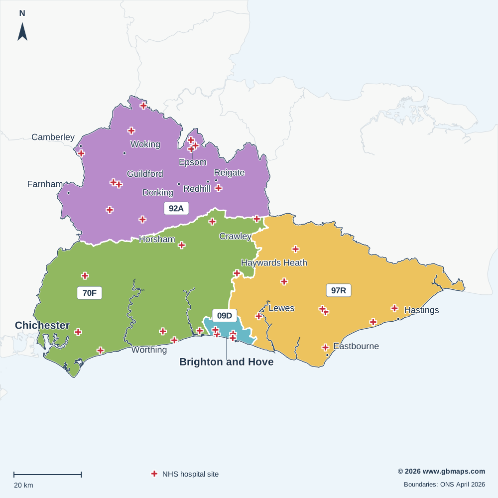
Explore the Surrey and Sussex ICB map, including Brighton and Hove, Chichester, Guildford and Woking. View the April 2026 boundary, local Sub-ICB areas and NHS hospital locations, or download the free vector PDF.
Established in April 2026 from all or parts of the former ICB areas listed below.
Inside Surrey and Sussex ICB
The Surrey and Sussex Integrated Care Board (ICB) boundary covers approximately 5,457 km² in the South East NHS region, extending roughly 84 km north to south and 128 km east to west.
Its 4 Sub-ICB locations show the local divisions within the ICB. The checked hospital directory includes 37 NHS trust or care-trust sites within the outline. The primary care extract records 71 PCNs associated with this ICB and 266 distinct GP practice codes.
Postal coverage reaches into 154 postcode districts and 502 postcode sectors. RH10, BN2, BN1, BN3, RH12 have the largest numbers of current postcode locations allocated to this ICB in the dataset. Explore the main postcode areas, NHS hospitals and local street maps below.
- Mapped area
- 5,457 km²
- Sub-ICB areas
- 4
- NHS hospital records
- 37
- Primary care networks
- 71
Explore other free ICB maps
36 current ICBsPrevious ICB areas Before April 2026
NHS hospitals on the map
37 named NHS trust or care-trust hospital records are shown. Private operators are excluded; sites sharing a location may have a single cross.
View the NHS hospital names and postcodes 37
- Aldrington CentreBN3 4AG
- Amberstone HospitalBN27 4HU
- Ashford HospitalTW15 3AA
- Bexhill HospitalTN40 2DZ
- Bognor Regis War Memorial HospitalPO22 9PP
- Brighton General HospitalBN2 3EW
- ChalkhillRH16 4NQ
- Conquest HospitalTN37 7RD
- Cranleigh Village HospitalGU6 8AE
- Crowborough War Memorial Hospital - Sussex Community NHS Foundation TrustTN6 1HB
- East Surrey HospitalRH1 5RH
- Eastbourne District General HospitalBN21 2UD
- Epsom HospitalKT18 7EG
- Farnham Road HospitalGU2 7LX
- Frimley Park HospitalGU16 7UJ
- Horsham HospitalRH12 2DR
- Langley Green HospitalRH11 7SE
- Lewes Victoria HospitalBN7 1PE
- MeadowfieldBN13 3EP
- Midhurst Community HospitalGU29 9AW
- Milford HospitalGU7 1UF
- Mill View HospitalBN3 7HY
- Princess Royal HospitalRH16 4EX
- Queen Victoria Hospital (East Grinstead)RH19 3DZ
- Royal Alexandra Children's HospitalBN2 5BE
- Royal Surrey County HospitalGU2 7XX
- Royal Sussex County HospitalBN2 5BE
- Southlands HospitalBN43 6TQ
- St Peter's HospitalKT16 0PZ
- St Richard's HospitalPO19 6SE
- Sussex Eye HospitalBN2 5BF
- Sussex Orthopaedic Treatment CentreRH16 4EY
- The Hellingly CentreBN27 4EP
- The Old Cottage HospitalKT17 4BL
- Uckfield HospitalTN22 5AW
- West Park HospitalKT19 8QJ
- Worthing HospitalBN11 2DH

MAKE THE MAP YOUR OWN
Colour and customise your ICB map
Highlight ICB areas, add place markers and labels, and build a map key for your report or presentation.
See the map assistant add a hospital marker and coloured drive-time areas in this example.
Open the ICB colouring toolMap sources and useful limits
Boundaries: ONS ICB and Sub-ICB locations, April 2026. Outlines are simplified for display; place and postcode matches use the original boundaries.
Hospital names come from the supplied hospital directory, matched to active NHS Organisation Data Service records on 13 November 2026. Only sites associated with NHS trusts or care trusts are included. This is a selection of hospital locations, not a list of current clinical services or commissioning relationships.
PCN count: the supplied 2026 primary care extract. Main postcode areas: the six largest areas with at least 2% of the ICB’s located current postcodes in the November 2026 dataset. A postcode area name does not mean its namesake town is inside the ICB.
Place names: Ordnance Survey. Contains OS data © Crown copyright and database right 2026. Contains Royal Mail data © Royal Mail copyright and database right 2026. Contains National Statistics data © Crown copyright and database right 2026. Map artwork © GBMaps.com.