Free Tunbridge Wells PDF Map
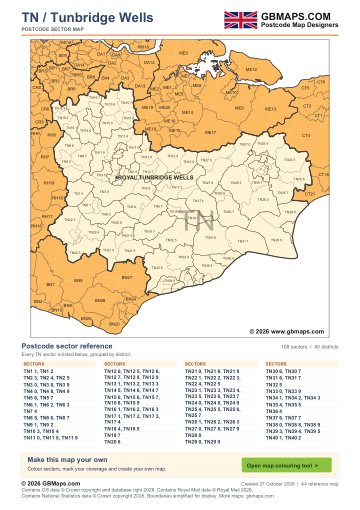
- Full TN postcode-area coverage
- PDF with GBMaps branding
- Includes a map colouring tool link
PDF
FreePDF download
For non-commercial use
Tunbridge Wells postcode sector maps · Free PDF and complete map bundle
Welcome back
Access your saved maps and downloads.
Need help accessing your account? Contact GBMaps.
TUNBRIDGE WELLS POSTCODE SECTOR MAP DOWNLOADS
See the 108 postcode sector boundaries within the Tunbridge Wells (TN) postcode area. Sectors divide districts into smaller areas for more detailed territory planning. Download the branded PDF free, or choose the complete bundle with a clean PDF, editable SVG and PNG, JPG and GIF images.
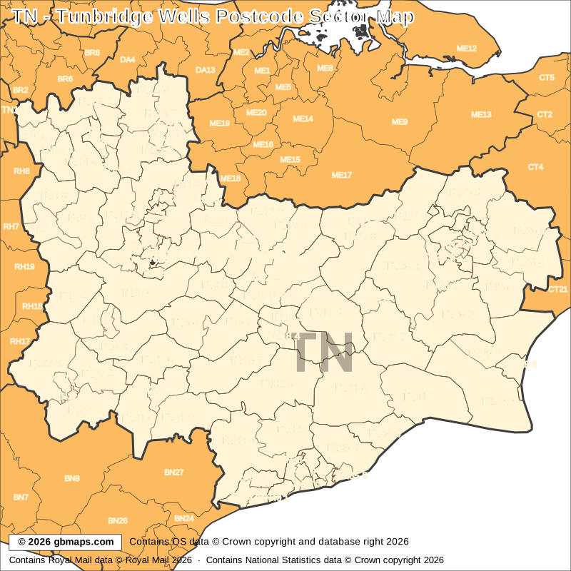
Explore the 108 mapped postcode sectors in the TN postcode area. Download the free Tunbridge Wells postcode sector map as a PDF, or choose the complete map bundle with a clean PDF, editable SVG and PNG, JPG and GIF images.
FreePDF download
For non-commercial use

£12including VAT
£10 + £2 VAT · One-off payment
The free PDF needs no email, account or payment. The bundle includes all five formats in one ZIP. Required map-data copyright credits are retained in both versions.

POSTCODE SECTOR COLOURING TOOL
See TN postcode sectors divided into 4 example territories, then use the online colouring tool to build a map for your sales or delivery areas.
Open the sector map colouring toolTN POSTCODE SECTORS AND PLACES
These 89 sectors each introduce at least one named place or locality not already shown in this directory. The complete map contains 108 sectors. Names are matched to sectors and grouped by shared outward code.
| Sector | Local places |
|---|---|
| TN1 postcode sectors | |
| TN1 1 | Royal Tunbridge Wells |
| TN2 postcode sectors | |
| TN2 4 | Pembury |
| TN3 postcode sectors | |
| TN3 0 | Rusthall, Bidborough, Fordcombe, Langton Green, Speldhurst |
| TN3 8 | Lamberhurst, The Down |
| TN3 9 | Groombridge, Bells Yew Green, Blackham, Eridge Green, Frant, Ashurst |
| TN4 postcode sectors | |
| TN4 0 | Southborough |
| TN5 postcode sectors | |
| TN5 6 | Best Beech Hill, Cousley Wood, Durgates, Tidebrook, Wadhurst |
| TN5 7 | Ticehurst, Flimwell, Stonegate, Three Leg Cross |
| TN6 postcode sectors | |
| TN6 1 | Crowborough, Friar's Gate |
| TN6 2 | Steel Cross |
| TN6 3 | Argos Hill, Boarshead, Greenhill, Jarvis Brook, Mark Cross |
| TN7 postcode sectors | |
| TN7 4 | Upper Hartfield, Coleman's Hatch, Hartfield, Withyham |
| TN8 postcode sectors | |
| TN8 5 | Edenbridge, Markbeech, Marsh Green |
| TN8 6 | Crockham Hill, Four Elms, Marlpit Hill |
| TN8 7 | Cowden, Bough Beech, Chiddingstone, Hever |
| TN9 postcode sectors | |
| TN9 1 | Tonbridge |
| TN10 postcode sectors | |
| TN10 4 | Higham Wood |
| TN11 postcode sectors | |
| TN11 0 | Hadlow, Crockhurst Street, Golden Green, Tudeley |
| TN11 8 | Leigh, Chiddingstone Causeway, Penshurst |
| TN11 9 | Dunk's Green, Hildenborough, Shipbourne |
| TN12 postcode sectors | |
| TN12 0 | Staplehurst, Cross-At-Hand, Hawkenbury |
| TN12 5 | East Peckham, Hale Street |
| TN12 6 | Paddock Wood, Beltring, Capel, Five Oak Green, Whetsted |
| TN12 7 | Matfield, Brenchley, Kipping's Cross |
| TN12 8 | Horsmonden |
| TN12 9 | Marden, Chainhurst, Claygate, Collier Street, Marden Thorn, Milebush |
| TN13 postcode sectors | |
| TN13 1 | Sevenoaks |
| TN13 2 | Dunton Green, Riverhead |
| TN14 postcode sectors | |
| TN14 5 | Otford |
| TN14 6 | Sevenoaks Weald, Chevening, Ide Hill, Sundridge, Whitley Row |
| TN14 7 | Knockholt Pound, Cudham, Horns Green, Badgers Mount, Halstead, Knockholt |
| TN15 postcode sectors | |
| TN15 0 | Ivy Hatch, Plaxtol, Seal, Stone Street, Underriver |
| TN15 6 | West Kingsdown, Heaverham, Kemsing |
| TN15 7 | Wrotham, Ash, Fairseat, Ridley, Stansted, Wrotham Heath |
| TN15 8 | Borough Green, Claygate Cross, Crouch, Platt |
| TN15 9 | Ightham |
| TN16 postcode sectors | |
| TN16 1 | Westerham, Brasted, Brasted Chart, Toy's Hill |
| TN16 2 | Tatsfield |
| TN16 3 | Biggin Hill |
| TN17 postcode sectors | |
| TN17 1 | Goudhurst, Curtisden Green |
| TN17 2 | Cranbrook, Cranbrook Common, Frittenden, Hartley, Iden Green, Kilndown |
| TN17 4 | Benenden, East End, Rolvenden, Rolvenden Layne |
| TN18 postcode sectors | |
| TN18 4 | Hawkhurst, High Street, The Moor |
| TN18 5 | Sandhurst, Four Throws, Gill's Green, Linkhill, Newenden |
| TN19 postcode sectors | |
| TN19 7 | Burwash, Burwash Common, Burwash Weald, Etchingham, Hurst Green, Silver Hill |
| Sector | Local places |
|---|---|
| TN20 postcode sectors | |
| TN20 6 | Mayfield, Butcher's Cross, Coggins Mill, Five Ashes |
| TN21 postcode sectors | |
| TN21 0 | Heathfield, Burlow, Cross In Hand, Foxhunt Green, Horam, Little London |
| TN21 8 | Broad Oak |
| TN21 9 | Chapel Cross, Cade Street, Dallington, Punnett's Town, Rushlake Green, Three Cups Corner |
| TN22 postcode sectors | |
| TN22 1 | Uckfield, Ringles Cross |
| TN22 2 | Maresfield |
| TN22 3 | Nutley, Fairwarp, Fletching |
| TN22 4 | Buxted, Hadlow Down, High Hurstwood |
| TN22 5 | Blackboys, Framfield, Isfield, Little Horsted |
| TN23 postcode sectors | |
| TN23 1 | Ashford |
| TN23 3 | Great Chart, Kingsnorth, Park Farm |
| TN24 postcode sectors | |
| TN24 0 | Sevington, Willesborough Lees |
| TN24 9 | Kennington |
| TN25 postcode sectors | |
| TN25 4 | Bilting, Boughton Aluph, Boughton Lees, Challock, Potters Corner |
| TN25 5 | Wye, Bodsham, Brabourne, Brook, Elmsted, Hassell Street |
| TN25 6 | Brabourne Lees, Lymbridge Green, Mersham, Sellindge, Smeeth, Stanford |
| TN25 7 | Aldington, Aldington Frith, Bilsington, Bonnington, Cheeseman's Green |
| TN26 postcode sectors | |
| TN26 1 | Shadoxhurst, Hothfield |
| TN26 2 | Ham Street, Appledore, Bromley Green, Hamstreet, Kenardington, Orlestone |
| TN26 3 | Woodchurch, Bethersden, Hengherst, High Halden, Shirkoak |
| TN27 postcode sectors | |
| TN27 0 | Charing, Charing Heath, Little Chart, Pluckley, Pluckley Thorne, Westwell Leacon |
| TN27 8 | Biddenden, Curteis' Corner, Haffenden Quarter, Maltman's Hill, Smarden, Standen |
| TN27 9 | Headcorn, Egerton, Egerton Forstal, Potter's Forstal |
| TN28 postcode sectors | |
| TN28 8 | New Romney, Greatstone-On-Sea, Littlestone-On-Sea |
| TN29 postcode sectors | |
| TN29 0 | St Mary's Bay, Burmarsh, Dymchurch, Ivychurch, Newchurch, Snave |
| TN29 9 | Lydd, Brenzett, Brookland, Lydd-On-Sea, Old Romney, Snargate |
| TN30 postcode sectors | |
| TN30 6 | Tenterden, St Michaels |
| TN30 7 | Leigh Green, Reading Street, Small Hythe, Stone In Oxney, The Stocks |
| TN31 postcode sectors | |
| TN31 6 | Northiam, Beckley, Brede, Broadland Row, Four Oaks |
| TN31 7 | Rye, Camber, East Guldeford, Iden, Playden, Rye Foreign |
| TN32 postcode sectors | |
| TN32 5 | Robertsbridge, Bodiam, Brightling, Cripp's Corner, Ewhurst Green, John's Cross |
| TN33 postcode sectors | |
| TN33 0 | Battle, Sedlescombe, Telham, Whatlington |
| TN33 9 | Ninfield, Catsfield, Crowhurst, Henley's Down, Hooe, Hooe Common |
| TN34 postcode sectors | |
| TN34 1 | Hastings |
| TN35 postcode sectors | |
| TN35 4 | Westfield, Cliff End, Fairlight, Fairlight Cove, Guestling Green, Pett |
| TN35 5 | Ore |
| TN36 postcode sectors | |
| TN36 4 | Winchelsea, Icklesham, Winchelsea Beach |
| TN37 postcode sectors | |
| TN37 7 | Baldslow |
| TN38 postcode sectors | |
| TN38 0 | St Leonards |
| TN38 8 | Bulverhythe |
| TN38 9 | Hollington |
| TN39 postcode sectors | |
| TN39 3 | Bexhill |
| TN39 4 | Cooden |
| TN39 5 | Lunsford's Cross, Sidley |
This is a place finder, not a list of every sector or address. A name appears once even when it spans several sectors. Use a current full postcode to check an address.
The free PDF is for non-commercial use and includes GBMaps branding and a map colouring tool link. The paid bundle includes a commercial-use licence, without promotional watermarks or tool links. Required map-data and GBMaps copyright credits remain. Email us about commercial use Map licence terms · Digital delivery and returns.