Free Chelmsford PDF Map
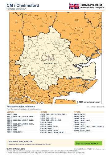
- Full CM postcode-area coverage
- PDF with GBMaps branding
- Includes a map colouring tool link
PDF
FreePDF download
For non-commercial use
Chelmsford postcode sector maps · Free PDF and complete map bundle
Welcome back
Access your saved maps and downloads.
Need help accessing your account? Contact GBMaps.
CHELMSFORD POSTCODE SECTOR MAP DOWNLOADS
See the 81 postcode sector boundaries within the Chelmsford (CM) postcode area. Sectors divide districts into smaller areas for more detailed territory planning. Download the branded PDF free, or choose the complete bundle with a clean PDF, editable SVG and PNG, JPG and GIF images.
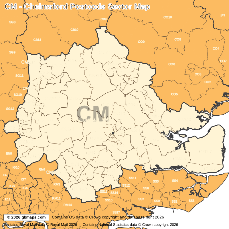
Explore the 81 mapped postcode sectors in the CM postcode area. Download the free Chelmsford postcode sector map as a PDF, or choose the complete map bundle with a clean PDF, editable SVG and PNG, JPG and GIF images.
FreePDF download
For non-commercial use
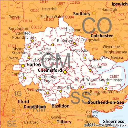
£12including VAT
£10 + £2 VAT · One-off payment
The free PDF needs no email, account or payment. The bundle includes all five formats in one ZIP. Required map-data copyright credits are retained in both versions.

POSTCODE SECTOR COLOURING TOOL
See CM postcode sectors divided into 4 example territories, then use the online colouring tool to build a map for your sales or delivery areas.
Open the sector map colouring toolCM POSTCODE SECTORS AND PLACES
These 63 sectors each introduce at least one named place or locality not already shown in this directory. The complete map contains 81 sectors. Names are matched to sectors and grouped by shared outward code.
| Sector | Local places |
|---|---|
| CM0 postcode sectors | |
| CM0 7 | Southminster, Asheldham, Bradwell On Sea, Dengie, Ramsey Island, St Lawrence |
| CM0 8 | Burnham-On-Crouch, Montsale, Ostend, Stoneyhills |
| CM1 postcode sectors | |
| CM1 1 | Chelmsford |
| CM1 3 | Writtle, Cooksmill Green, Edney Common, Loves Green |
| CM1 4 | Boyton Cross, Chalk End, Chignall Smealy, Chignall St James, Good Easter |
| CM1 7 | Broomfield |
| CM2 postcode sectors | |
| CM2 7 | Howe Green, Sandon |
| CM2 8 | Galleywood, West Hanningfield, Widford |
| CM2 9 | Great Baddow |
| CM3 postcode sectors | |
| CM3 1 | Great Leighs, Broad's Green, Ford End, Great Waltham, Hartford End, Howe Street |
| CM3 2 | Hatfield Peverel, Crix, Fairstead, Fuller Street, Gamble's Green, Nounsley |
| CM3 3 | Boreham, Little Waltham |
| CM3 4 | Danbury, Bicknacre, Little Baddow |
| CM3 5 | South Woodham Ferrers |
| CM3 6 | Maylandsea, Althorne, Cock Clarks, Cold Norton, Great Canney, Hazeleigh |
| CM3 8 | East Hanningfield, Rettendon, Rettendon Place, South Hanningfield, Woodham Ferrers |
| CM4 postcode sectors | |
| CM4 0 | Ingatestone, Beggar Hill, Blackmore, Fryerning, Mill Green, Nine Ashes |
| CM4 9 | Stock, Heybridge, Margaretting |
| CM5 postcode sectors | |
| CM5 0 | Chipping Ongar, Abbess Roding, Beauchamp Roding, Berners Roding, Bobbingworth, Clatterford End |
| CM5 9 | Greensted, High Ongar, Little End, Norton Mandeville, Stanford Rivers |
| CM6 postcode sectors | |
| CM6 1 | Great Dunmow, Aythorpe Roding, Bacon End, Bishop's Green, Great Canfield, High Roding |
| CM6 2 | Thaxted, Broxted, Cherry Green, Chickney, Churchend, Cutlers Green |
| CM6 3 | Felsted, Bannister Green, Bardfield End Green, Barnston, Bran End, Duck End |
| CM7 postcode sectors | |
| CM7 1 | Braintree |
| CM7 4 | Great Bardfield, Blackmore End, Cornish Hall End, Finchingfield, Little Bardfield |
| CM7 5 | Bardfield Saling, Beazley End, Bocking Churchstreet, Church End, Great Saling |
| CM7 9 | Bocking |
| CM8 postcode sectors | |
| CM8 1 | Witham, Chipping Hill, Faulkbourne, White Notley |
| CM8 3 | Silver End, Great Braxted, Little Braxted, Rivenhall, Rivenhall End, Wickham Bishops |
| CM9 postcode sectors | |
| CM9 4 | Heybridge Basin, Langford |
| CM9 5 | Maldon |
| CM9 6 | Mundon, Ulting, Woodham Mortimer, Woodham Walter |
| Sector | Local places |
|---|---|
| CM9 postcode sectors (continued) | |
| CM9 8 | Tollesbury, Broad Street Green, Goldhanger, Great Totham, Little Totham, Salcott |
| CM11 postcode sectors | |
| CM11 1 | Billericay, Downham, Ramsden Bellhouse, Ramsden Heath |
| CM11 2 | Crays Hill, Great Burstead, South Green |
| CM12 postcode sectors | |
| CM12 9 | Little Burstead |
| CM13 postcode sectors | |
| CM13 1 | Brentwood, Hutton |
| CM13 3 | Herongate, Childerditch, Dunton Wayletts, Great Warley, Ingrave, Little Warley |
| CM14 postcode sectors | |
| CM14 5 | Brook Street, Coxtie Green, Kelvedon Hatch, Navestock Side, South Weald |
| CM15 postcode sectors | |
| CM15 0 | Doddinghurst, Mountnessing, Stondon Massey, Wyatt's Green |
| CM15 8 | Shenfield |
| CM15 9 | Pilgrims Hatch |
| CM16 postcode sectors | |
| CM16 4 | Epping |
| CM16 6 | North Weald, Epping Green, Epping Upland, North Weald Bassett, Thornwood Common, Tyler's Green |
| CM16 7 | Theydon Bois, Fiddlers Hamlet |
| CM17 postcode sectors | |
| CM17 0 | Harlow, Churchgate Street, Matching, Matching Green, Matching Tye, Threshers Bush |
| CM17 9 | Foster Street, Hastingwood |
| CM18 postcode sectors | |
| CM18 7 | Potter Street |
| CM19 postcode sectors | |
| CM19 5 | Great Parndon, Roydon |
| CM20 postcode sectors | |
| CM20 2 | Eastwick, Gilston |
| CM21 postcode sectors | |
| CM21 0 | Sawbridgeworth, Allen's Green, High Wych |
| CM21 9 | Lower Sheering |
| CM22 postcode sectors | |
| CM22 6 | Takeley, Bamber's Green, Elsenham, Henham, Hope End Green, Molehill Green |
| CM22 7 | Hatfield Heath, Bedlar's Green, Great Hallingbury, Hatfield Broad Oak, Little Hallingbury, Sheering |
| CM23 postcode sectors | |
| CM23 1 | Manuden, Berden, Farnham, Farnham Green, Hazel End |
| CM23 2 | Bishop's Stortford |
| CM23 4 | Spellbrook |
| CM23 5 | Birchanger |
| CM24 postcode sectors | |
| CM24 1 | London Stansted Airport |
| CM24 8 | Stansted Mountfitchet |
| CM77 postcode sectors | |
| CM77 6 | Rayne |
| CM77 7 | Great Notley |
| CM77 8 | Black Notley, Bradwell, Cressing, Pattiswick, Stisted, Tye Green |
This is a place finder, not a list of every sector or address. A name appears once even when it spans several sectors. Use a current full postcode to check an address.
The free PDF is for non-commercial use and includes GBMaps branding and a map colouring tool link. The paid bundle includes a commercial-use licence, without promotional watermarks or tool links. Required map-data and GBMaps copyright credits remain. Email us about commercial use Map licence terms · Digital delivery and returns.