
East Midlands 4-Digit postcode sector map
The East Midlands of England is divided up into 11 different postcode areas. Each postcode area is divided up unto numerous smaller districts. You can download a vector based pdf map of each of the individual postcode areas of the East Midlands showing the areas and districts including labels by clicking on the links down the right hand side of this page.
>> Go Back to FULL UK Postcode Map

 DN Doncaster
 S Sheffield
 DE Derby
 NG Nottingham
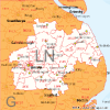 LN Lincoln
 LE Leicester
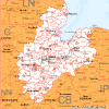 PE Peterborough
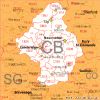 CB Cambridge
 IP Ipswich
 NR Norwich
 CO Colchester