FREE DONCASTER POSTCODE SECTOR MAP
DN – Doncaster Postcode Sector Map 104 mapped sectors · DN1 1 to DN41 8
Explore the 104 mapped postcode sectors in the DN postcode area. The map labels sectors; the directory highlights those with distinct sector-matched places and localities.
Download the Doncaster postcode sector map
Orange sector artwork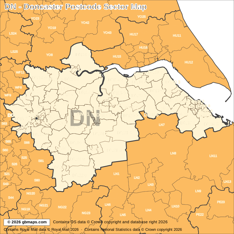
Free editable vector postcode map downloads
Also available as free postcode map images

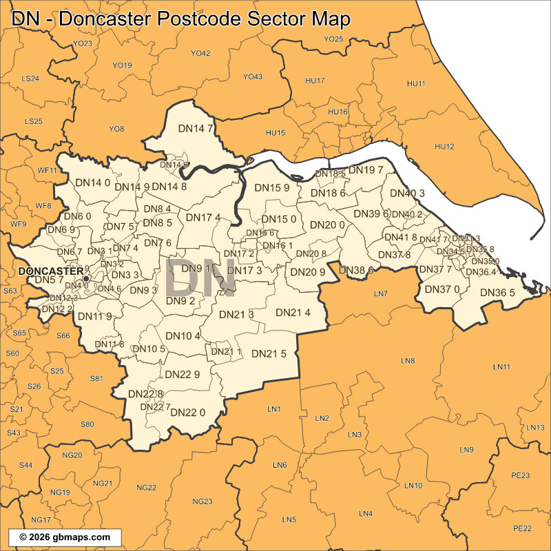
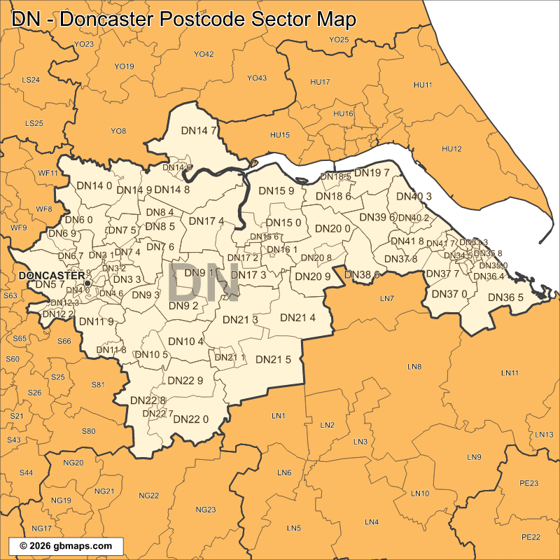
PDF and SVG remain sharp at any size. PNG, JPG and GIF are 800-pixel images. Check the map credits before reuse.

POSTCODE SECTOR COLOURING TOOL
Make your own Doncaster sector map
See DN postcode sectors divided into 4 example territories, then use the online colouring tool to build a map for your sales or delivery areas.
Open the sector map colouring toolDN POSTCODE SECTORS AND PLACES
DN postcode sector directory
These 72 sectors each introduce at least one named place or locality not already shown in this directory. The complete map contains 104 sectors. Names are matched to sectors and grouped by shared outward code.
| Sector | Local places |
|---|---|
| DN1 postcode sectors | |
| DN1 1 | Doncaster |
| DN3 postcode sectors | |
| DN3 1 | Barnby Dun, Kirk Sandall |
| DN3 2 | Edenthorpe |
| DN3 3 | Armthorpe, Branton, Old Cantley |
| DN4 postcode sectors | |
| DN4 6 | Bessacarr |
| DN4 8 | Warmsworth |
| DN5 postcode sectors | |
| DN5 0 | Bentley, Arksey, Toll Bar |
| DN5 7 | Sprotbrough, Barnburgh, Brodsworth, Cadeby, Clayton, Harlington |
| DN6 postcode sectors | |
| DN6 0 | Askern, Fenwick, Moss, Thorpe In Balne |
| DN6 7 | Adwick Le Street, Hampole, Highfields |
| DN6 8 | Carcroft, Skellow |
| DN6 9 | Norton, Burghwallis, Campsall, Sutton, Walden Stubbs, Womersley |
| DN7 postcode sectors | |
| DN7 4 | Hatfield |
| DN7 5 | Stainforth, Braithwaite, Fishlake, Kirk Bramwith |
| DN7 6 | Dunscroft, Dunsville, Hatfield Woodhouse |
| DN8 postcode sectors | |
| DN8 4 | Moorends |
| DN8 5 | Thorne, Sandtoft |
| DN9 postcode sectors | |
| DN9 1 | Epworth, Beltoft, Belton, Low Burnham, Owston Ferry, Westgate |
| DN9 2 | Westwoodside, East Lound, Graizelound, Haxey, Wroot |
| DN9 3 | Hayfield Green, Auckley, Blaxton, Finningley |
| DN10 postcode sectors | |
| DN10 4 | Misterton, Beckingham, Gringley On The Hill, Walkeringham, West Stockwith |
| DN10 5 | Everton, Mattersey, Wiseton |
| DN10 6 | Bawtry, Austerfield, Misson, Scaftworth, Scrooby |
| DN11 postcode sectors | |
| DN11 0 | Rossington, New Rossington |
| DN11 8 | Harworth, Bircotes, Styrrup |
| DN11 9 | Tickhill, Loversall, Wadworth |
| DN12 postcode sectors | |
| DN12 1 | New Edlington |
| DN12 2 | Conisbrough |
| DN12 4 | Old Denaby |
| DN14 postcode sectors | |
| DN14 0 | Eggborough, Gowdall, Pollington, Balne, Beal, Great Heck |
| DN14 5 | Goole, Hook |
| DN14 7 | Howden, Asselby, Balkholme, Barmby On The Marsh, Blacktoft, Brind |
| DN14 8 | Rawcliffe, Adlingfleet, Airmyn, Ousefleet, Rawcliffe Bridge, Reedness |
| DN14 9 | Snaith, Sykehouse, East Cowick, West Cowick, Carlton |
| DN15 postcode sectors | |
| DN15 0 | Appleby, High Risby, Low Risby, Roxby, Santon |
| DN15 6 | Scunthorpe |
| DN15 8 | Crosby, Flixborough, Flixborough Stather, Gunness |
| DN15 9 | Winterton, Alkborough, Burton Upon Stather, Coleby, Normanby, Thealby |
| Sector | Local places |
|---|---|
| DN16 postcode sectors | |
| DN16 1 | Brumby |
| DN16 3 | Ashby, Bottesford |
| DN17 postcode sectors | |
| DN17 2 | Yaddlethorpe |
| DN17 3 | Messingham, Susworth, Althorpe, Burringham, Derrythorpe, East Butterwick |
| DN17 4 | Crowle, Amcotts, Ealand, Eastoft, Fockerby, Garthorpe |
| DN18 postcode sectors | |
| DN18 5 | Barton-Upon-Humber, Humber Bridge |
| DN18 6 | Burnham, Ferriby Sluice, Horkstow, South Ferriby |
| DN19 postcode sectors | |
| DN19 7 | Barrow Upon Humber, Goxhill, Goxhill Haven, New Holland, South End |
| DN20 postcode sectors | |
| DN20 0 | Broughton, Bonby, Elsham, Saxby All Saints, Worlaby, Wressle |
| DN20 8 | Brigg, Wrawby |
| DN20 9 | Hibaldstow, Cadney, Scawby |
| DN21 postcode sectors | |
| DN21 1 | Gainsborough |
| DN21 3 | Scotter, Blyton, East Ferry, East Stockwith, Laughton, Morton |
| DN21 4 | Kirton In Lindsey, Blyborough, Brandy Wharf, Grayingham, Northorpe, Snitterby |
| DN21 5 | Lea, Aisby, Corringham, Fillingham, Gate Burton, Glentworth |
| DN22 postcode sectors | |
| DN22 0 | North Leverton, Cottam, East Drayton, Eaton, Gamston, Grove |
| DN22 6 | Retford |
| DN22 8 | Ranskill, Babworth, Barnby Moor, Bothamsall, Elkesley, Haughton |
| DN22 9 | Clarborough, Bole, Clayworth, Hayton, North Wheatley, Saundby |
| DN31 postcode sectors | |
| DN31 1 | Grimsby |
| DN33 postcode sectors | |
| DN33 1 | Bradley |
| DN35 postcode sectors | |
| DN35 0 | Cleethorpes |
| DN36 postcode sectors | |
| DN36 4 | New Waltham, Humberston, Scartho |
| DN36 5 | Holton Le Clay, Eskham, Grainsby, Ludborough, Marshchapel, North Cotes |
| DN37 postcode sectors | |
| DN37 0 | Waltham, Thorganby, Ashby Cum Fenby, Barnoldby Le Beck, Beelsby, Brigsley |
| DN37 7 | Laceby, Aylesby, Irby Upon Humber |
| DN37 8 | Great Limber, Riby |
| DN37 9 | Great Coates |
| DN38 postcode sectors | |
| DN38 6 | Barnetby Le Wold, Bigby, Grasby, Searby, Melton Ross |
| DN39 postcode sectors | |
| DN39 6 | Ulceby, Croxton, Kirmington, Thornton Curtis, Wootton |
| DN40 postcode sectors | |
| DN40 1 | Immingham |
| DN40 3 | South Killingholme, Habrough, East Halton, North Killingholme |
| DN41 postcode sectors | |
| DN41 7 | Healing |
| DN41 8 | Keelby, Brocklesby, Stallingborough |
This is a place finder, not a list of every sector or address. A name appears once even when it spans several sectors. Use a current full postcode to check an address.
Looking for another postcode area?
Our maps are free for non-commercial use. Commercial use requires a licence for a small one-off charge. Please retain all supplied copyright notices. The GBMaps copyright notice must appear on the map itself in every format; vector maps (PDF and SVG) must also display the Ordnance Survey, Royal Mail and other supplied data acknowledgements. Email us about commercial use.