FREE NHS ICB MAPS · LONDON
West and North London ICB map
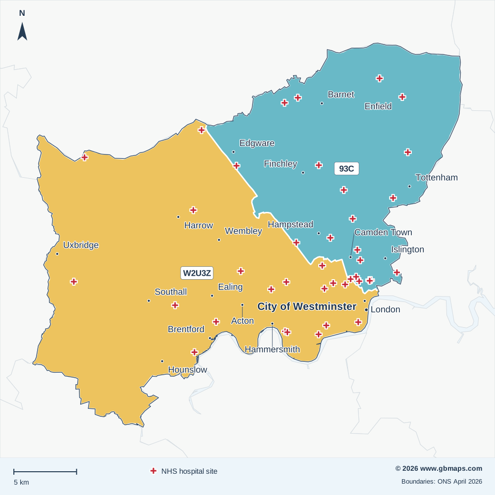
Explore the West and North London ICB map, including London, City of Westminster, Harrow and Wembley. View the April 2026 boundary, Sub-ICB coverage and NHS hospital locations, or download the free vector PDF.
Established in April 2026 from all or parts of the former ICB areas listed below.
Inside West and North London ICB
The West and North London Integrated Care Board (ICB) boundary covers approximately 606 km² in the London NHS region, extending roughly 31 km north to south and 34 km east to west.
Its 2 Sub-ICB locations show the local divisions within the ICB. The checked hospital directory includes 44 NHS trust or care-trust sites within the outline. The primary care extract records 80 PCNs associated with this ICB and 516 distinct GP practice codes.
Postal coverage reaches into 163 postcode districts and 656 postcode sectors. NW10, NW1, N1, SW6, NW9 have the largest numbers of current postcode locations allocated to this ICB in the dataset. Explore the main postcode areas, NHS hospitals and local street maps below.
- Mapped area
- 606 km²
- Sub-ICB areas
- 2
- NHS hospital records
- 44
- Primary care networks
- 80
Explore other free ICB maps
36 current ICBsPrevious ICB areas Before April 2026
NHS hospitals on the map
44 named NHS trust or care-trust hospital records are shown. Private operators are excluded; sites sharing a location may have a single cross.
View the NHS hospital names and postcodes 44
- Barnet HospitalEN5 3DJ
- Camden Mews Day HospitalNW1 9DB
- Central Middlesex HospitalNW10 7NS
- Charing Cross HospitalW6 8RF
- Chase Farm HospitalEN2 8JL
- Chelsea and Westminster HospitalSW10 9NH
- Clayponds Rehabilitation HospitalW5 4RN
- Ealing HospitalUB1 3HW
- Edgware Community HospitalHA8 0AD
- Finchley Memorial HospitalN12 0JE
- Fordwych Road Day HospitalNW2 3TL
- Great Ormond Street HospitalWC1N 3JH
- Hadley Wood HospitalEN5 5TS
- Hammersmith & Fulham Mental Health UnitW6 8NF
- Hammersmith HospitalW12 0HS
- Hillingdon HospitalUB8 3NN
- Hospital For Tropical DiseasesWC1E 6JD
- Hospital Of St John & St ElizabethNW8 9NH
- Moorfields Eye Hospital (City Road)EC1V 2PD
- Mount Vernon HospitalHA6 2RN
- National Hospital For Neurology and Neurosurgery, Queen SquareWC1N 3BG
- North Middlesex University HospitalN18 1QX
- Northwick Park HospitalHA1 3UJ
- Northwood & Pinner Community HospitalHA6 2RN
- Queen Charlotte's & Chelsea HospitalW12 0HS
- Royal Free HospitalNW3 2QG
- Royal National ENT and Eastman Dental HospitalsWC1E 6DG
- Royal National Orthopaedic Hospital (Bolsover Street)W1W 5AQ
- St Andrews CourtEN1 3SY
- St Charles Hospital, Mental Health UnitW10 6DZ
- St Lukes Woodside HospitalN10 3HU
- St Mark's HospitalHA1 3UJ
- St Mary's Hospital (HQ)W2 1NY
- St Pancras HospitalNW1 0PE
- St. Ann's HospitalN15 3TH
- The Gordon HospitalSW1V 2RH
- The Royal London Hospital For Integrated MedicineWC1N 3HR
- The Royal Marsden Hospital (London)SW3 6JJ
- The Royal National Orthopaedic Hospital (Stanmore)HA7 4LP
- The Whittington HospitalN19 5NF
- University College HospitalNW1 2BU
- University College Hospital at Westmoreland StreetW1G 8PH
- West Middlesex University HospitalTW7 6AF
- Western Eye HospitalNW1 5QH

MAKE THE MAP YOUR OWN
Colour and customise your ICB map
Highlight ICB areas, add place markers and labels, and build a map key for your report or presentation.
See the map assistant add a hospital marker and coloured drive-time areas in this example.
Open the ICB colouring toolMap sources and useful limits
Boundaries: ONS ICB and Sub-ICB locations, April 2026. Outlines are simplified for display; place and postcode matches use the original boundaries.
Hospital names come from the supplied hospital directory, matched to active NHS Organisation Data Service records on 13 November 2026. Only sites associated with NHS trusts or care trusts are included. This is a selection of hospital locations, not a list of current clinical services or commissioning relationships.
PCN count: the supplied 2026 primary care extract. Main postcode areas: the six largest areas with at least 2% of the ICB’s located current postcodes in the November 2026 dataset. A postcode area name does not mean its namesake town is inside the ICB.
Place names: Ordnance Survey. Contains OS data © Crown copyright and database right 2026. Contains Royal Mail data © Royal Mail copyright and database right 2026. Contains National Statistics data © Crown copyright and database right 2026. Map artwork © GBMaps.com.