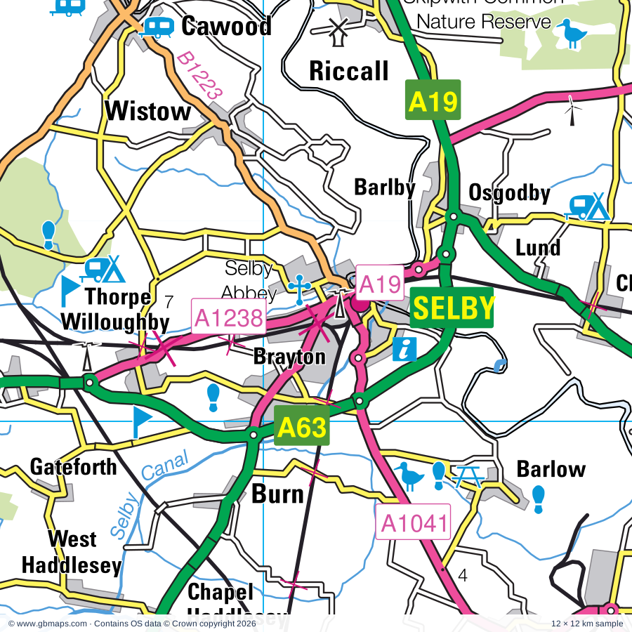
Selby & Goole regional road map. Full 60 × 60 km PDF, SVG and Illustrator files, with a free PDF sample.

GBMAPS.COM

Selby & Goole Regional Road Map

Call Us Now for Help01751 473136

GREAT BRITAIN ROAD ATLAS · 1:250,000 RY-01S

Selby & the lower Ouse

Explore the full 60 × 60 km Selby & Goole regional road map at 1:250,000, covering Knottingley, Pontefract, Castleford, Hemsworth, Normanton. Compare the complete coverage below; a detailed PDF sample is available free.

SELBY & THE LOWER OUSEREGIONAL ROAD MAP
60 × 60 km · Full map previewDownload the free SVG ↓

INSIDE THE FULL 60 × 60 KM MAP

Explore the Selby & Goole map area

1:250,000 cartography

Towns, villages & places

More mapped places (292)

Roads across this sheet

M1, M18, M62, M180, M621, A1(M), A18, A19, A58, A58(M), A60, A61, A62, A63, A64, A64(M), A65, A161, A162, A163, A168, A614, A618, A628

More road numbers

A629, A630, A631, A633, A634, A635, A636, A637, A638, A639, A642, A643, A644, A645, A647, A649, A650, A651, A652, A653, A654, A655, A656, A657, A658, A659, A660, A661, A1036, A1041, A1079, A1146, A1237, A1238, A1246, A6021, A6022, A6023, A6029, A6032, A6102, A6109, A6110, A6120, A6123, A6133, A6135, A6178, A6182, A6186, A6195, A6201, A6539, B1217, B1220, B1222, B1223, B1224, B1228, B1230, B1246, B1396, B1403, B6045, B6060, B6066, B6067, B6076, B6077, B6082, B6086, B6087, B6088, B6089, B6090, B6091, B6092, B6093, B6094, B6096, B6097, B6098, B6099, B6100, B6106, B6115, B6116, B6117, B6118, B6122, B6123, B6124, B6125, B6126, B6127, B6128, B6129, B6131, B6132, B6133, B6134, B6135, B6136, B6137, B6152, B6154, B6155, B6156, B6157, B6159, B6161, B6164, B6273, B6376, B6378, B6389, B6409, B6410, B6411, B6421, B6422, B6427, B6428, B6449, B6451, B6462, B6463, B6474, B6475, B6481, B6546

Rivers & waterways

Abbey Brook, Aire & Calder Navigation, Barnsley Canal (disused), Calder & Hebble Navigation, Canal (disused), Chesterfield Canal, Cock Beck, Dutch River, Elsecar Canal (disused), Leeds & Liverpool Canal, New Junction Canal, Pocklington Canal

More waterways

River Aire, River Calder, River Dearne, River Derwent, River Don, River Dun Navigation, River Foulness, River Idle, River Loxley, River Ouse, River Rother, River Ryton, River Torne, River Washburn, River Went, River Wharfe, Selby Canal, Sheffield & Keadby Canal, Sheffield & South Yorkshire Navigation, Sheffield & Tinsley Canal, Stainforth & Keadby Canal, The Porter or Little Don River

Landmarks & landscape

Abbey House Museum, Anglers Country Park, Armley Mills Museum, Bagshaw Museum, Barlow Common Nature Reserve, Belton, Birdwell Lodge Craft Centre, Bramham Park, Bramham Park Gardens, Bretton Country Park, Brodsworth Hall and Gardens, Broomhill Flash Nature Reserve, PEAK DISTRICT NATIONAL PARK

More named features

Campsall Country Park, Cannon Hall Country Park, Cannon Hall Farm, Cannon Hall House & Museum, Carlton Towers, Castleford Museum, Cawthorne Museum, Charlotte's Jersey Ice Cream Parlour, Clifton Park Museum, Conisbrough Castle, Conisbrough Castle and Visitor Centre, Cusworth Country Park, Delta Force Paintball Leeds (Leewood), Denaby Ings Nature Reserve, Dewsbury Minster Heritage Centre, Dewsbury Museum, Diggerland (Yorkshire), Doncaster Museum & Art Gallery, Doncaster Aeroventure, Doncaster Racecourse, Elsecar Industrial Heritage Centre, Elsecar Steam Railway, Epworth Old Rectory, Fairburn Ings Nature Reserve, Fairburn Ings Visitor Centre, Fitzwilliam Country Park, Glissing Centre, Wakefield Museum, Golden Acre Park and Gardens, Goole Museum and Art Gallery, Harewood House, Harewood House Bird Garden, Harewood House and Garden, Haxey Nature Reserve, Haxey Reserve, Highfields Country Park, Home Farm, Horsforth Village Museum, Howden Church, Howell Wood Country Park, King's Wood, Kirklees Light Railway, Kirkstall Abbey, Leeds Cathedral, Leeds Metropolitan University Gallery, Leeds City Art Gallery, Lotherton Hall, Lotherton Hall Deer Park, Lotherton Hall Bird Garden, Lotherton Hall Formal Gardens, Lower Derwent Valley National Nature Reserve, Magna, Maltby Low Common, Meanwood Valley Urban Farm, Melton Wood Country Park, Middleton Park Visitor Centre, Middleton Railway, Monk Bretton Priory, Monument, Moravian Museum, Museum of South Yorkshire Life, National Coal Mining Museum for England, Newmillerdam Country Park, Nostell Priory, Oakwell Hall, Oakwell Hall Country Park, Old Moor Wetlands Centre, Phillis Harvey Horse & Donkey Trust, Phoenix Park, Ponderosa Rural Therapeutic Centre & Rare Breeds Farm, Pontefract Castle, Pontefract Museum, Pontefract Racecourse, Potteric Carr Nature Reserve, Pugneys Country Park, Rabbit Ings Country Park, Rodley Nature Reserve, Roundhay Park, Royal Armouries Museum, Leeds Museum Discovery Centre, Leeds City Museum, Sandal Castle, Sandal Castle (Remains of), Sandall Beat Wood Nature Reserve, Sandtoft Transport Centre, Selby Abbey, Skipwith Common Nature Reserve, South Yorkshire Transport Museum, Sprotbrough Flash, St Aldan's Nature Reserve Point & Visitor Centre, Stanley Marsh Local Nature Reserve, Steeton Hall Gatehouse, Stillingfleet Lodge Gardens, Stockeld Park, Temple Newsam Country Park, Temple Newsam House, Thackray Medical Museum, The Cathedral Church of All Saints, The Hepworth Wakefield, The Real Aeroplane Co Ltd, The Red House Museum, The Waterways Museum, Thorpe Marsh Nature Reserve, Thrybergh Country Park, Thrybergh Country Park Nature Reserve, Thrybergh Country Park Visitor Centre, Thwaite Mills Industrial Museum, Tropical World, Visitor Centre, Wentworth Castle, Wentworth Castle Gardens, Westwood Country Park, Wetherby Racecourse, Wheldrake Ings Nature Reserve, Wingfield Farm, Worsbrough Country Park, Worsbrough Mill Museum, Wortley Top Forge Museum, Xscape (Castleford), York Racecourse, Yorkshire Air Museum, Yorkshire Sculpture Park, Yorkshire Wildlife Centre

Local authority & parish coverage

Wholly or partly within the full map rectangle. These boundaries are coverage information, not additional artwork layers.

  • Barnsley DistrictPartly within
  • Bassetlaw DistrictPartly within
  • Bradford DistrictPartly within
  • Doncaster DistrictWholly within
  • East Riding of YorkshirePartly within
  • Kirklees DistrictPartly within
  • Leeds DistrictPartly within
  • North LincolnshirePartly within
  • North YorkshirePartly within
  • Rotherham DistrictPartly within
  • Sheffield DistrictPartly within
  • Wakefield DistrictWholly within
  • West Lindsey DistrictPartly within
  • YorkPartly within
Wards & electoral divisions 186 areas
  • Ackworth, North Elmsall & Upton Ward
  • Adel & Wharfedale Ward
  • Adwick le Street & Carcroft Ward
  • Airedale & Ferry Fryston Ward
  • Almondbury Ward (part)
  • Altofts & Whitwood Ward
  • Alwoodley Ward
  • Ardsley & Robin Hood Ward
  • Armley Ward
  • Armthorpe Ward
  • Athersley & New Lodge Ward
  • Axholme Central Ward (part)
  • Axholme North Ward (part)
  • Axholme South Ward (part)
  • Balby South Ward
  • Batley East Ward
  • Batley West Ward
  • Beckingham Ward (part)
  • Beeston & Holbeck Ward
  • Bentley Ward
  • Bessacarr Ward
  • Birstall & Birkenshaw Ward (part)
  • Bishopthorpe Ward
  • Blyth Ward (part)
  • Boston Castle Ward (part)
  • Bramley & Ravenfield Ward
  • Bramley & Stanningley Ward
  • Brinsworth Ward (part)
  • Burmantofts & Richmond Hill Ward
  • Burngreave Ward (part)
  • Calverley & Farsley Ward (part)
  • Castleford Central & Glasshoughton Ward
  • Central Ward
  • Chapel Allerton Ward
  • Clayworth Ward (part)
  • Cleckheaton Ward (part)
  • Conisbrough Ward
  • Copmanthorpe Ward
  • Crofton, Ryhill & Walton Ward
  • Cross Gates & Whinmoor Ward
  • Cudworth Ward
  • Dalton & Thrybergh Ward
  • Darfield & Great Houghton Ward
  • Darnall Ward (part)
  • Darton East Ward
  • Darton West Ward
  • Dearne North Ward
  • Dearne South Ward
  • Denby Dale Ward (part)
  • Dewsbury East Ward
  • Dewsbury South Ward
  • Dewsbury West Ward
  • Dinnington Ward (part)
  • Dodworth, Stainborough & Tankersley Ward
  • Dringhouses & Woodthorpe Ward (part)
  • East Ecclesfield Ward
  • Edenthorpe & Kirk Sandall Ward
  • Edlington & Warmsworth Ward
  • Everton Ward (part)
  • Farnley & Wortley Ward
  • Featherstone Ward
  • Finningley Ward
  • Firth Park Ward
  • Fishergate Ward (part)
  • Fulford & Heslington Ward (part)
  • Garforth & Swillington Ward
  • Gipton & Harehills Ward
  • Goole North Ward
  • Goole South Ward
  • Greasbrough Ward
  • Guiseley & Rawdon Ward (part)
  • Harewood Ward
  • Harworth Ward
  • Hatfield Ward
  • Headingley & Hyde Park Ward
  • Heckmondwike Ward (part)
  • Hellaby & Maltby West Ward
  • Hemsworth Ward
  • Hexthorpe & Balby North Ward
  • Hillsborough Ward (part)
  • Holme Wood & Bierley Ward (part)
  • Hoober Ward
  • Horbury & South Ossett Ward
  • Horsforth Ward (part)
  • Howden Ward
  • Howdenshire Ward (part)
  • Hoyland Milton Ward
  • Hull Road Ward (part)
  • Hunslet & Riverside Ward
  • Idle & Thackley Ward (part)
  • Keppel Ward
  • Killingbeck & Seacroft Ward
  • Kilnhurst & Swinton East Ward
  • Kingstone Ward
  • Kippax & Methley Ward
  • Kirkburton Ward (part)
  • Kirkstall Ward
  • Knottingley & Ferrybridge Ward
  • Little London & Woodhouse Ward
  • Liversedge & Gomersal Ward (part)
  • Maltby East Ward (part)
  • Mexborough Ward
  • Micklegate Ward (part)
  • Middleton Park Ward
  • Mirfield Ward (part)
  • Misterton Ward
  • Monk Bretton Ward
  • Moortown Ward
  • Morley North Ward
  • Morley South Ward
  • Normanton Ward
  • North East Ward
  • Norton & Askern Ward
  • Old Town Ward
  • Osbaldwick & Derwent Ward (part)
  • Ossett Ward
  • Otley & Yeadon Ward (part)
  • Penistone East Ward
  • Penistone West Ward (part)
  • Pocklington Provincial Ward (part)
  • Pontefract North Ward
  • Pontefract South Ward
  • Pudsey Ward (part)
  • Ranskill Ward (part)
  • Rawmarsh East Ward
  • Rawmarsh West Ward
  • Rockingham Ward
  • Roman Ridge Ward
  • Rossington & Bawtry Ward
  • Rotherham East Ward
  • Rotherham West Ward
  • Rothwell Ward
  • Roundhay Ward
  • Royston Ward
  • Rural West York Ward (part)
  • Scotter and Blyton Ward (part)
  • Shiregreen & Brightside Ward
  • Sitwell Ward (part)
  • Snaith, Airmyn, Rawcliffe and Marshland Ward (part)
  • South Elmsall & South Kirkby Ward
  • Southey Ward
  • Sprotbrough Ward
  • Stainforth & Barnby Dun Ward
  • Stairfoot Ward
  • Stanley & Outwood East Ward
  • Stannington Ward (part)
  • Stocksbridge & Upper Don Ward (part)
  • Swinton Rockingham Ward
  • Temple Newsam Ward
  • Thorne & Moorends Ward
  • Thurcroft & Wickersley South Ward (part)
  • Tickhill & Wadsworth Ward
  • Town Ward
  • Wakefield East Ward
  • Wakefield North Ward
  • Wakefield Rural Ward
  • Wakefield South Ward
  • Wakefield West Ward
  • Wath Ward
  • Weetwood Ward
  • West Ecclesfield Ward
  • Westfield Ward (part)
  • Wetherby Ward (part)
  • Wheatley Hills & Intake Ward
  • Wheldrake Ward
  • Wickersley North Ward
  • Wolds Weighton Ward (part)
  • Wombwell Ward
  • Worsbrough Ward
  • Wrenthorpe & Outwood West Ward
  • Appleton Roebuck & Church Fenton ED
  • Barlby & Riccall ED
  • Brayton & Barlow ED
  • Camblesforth & Carlton ED
  • Cawood & Escrick ED
  • Cliffe & North Duffield ED
  • Monk Fryston & South Milford ED
  • Osgoldcross ED
  • Ouseburn ED (part)
  • Selby East ED
  • Selby West ED
  • Sherburn in Elmet ED
  • Spofforth with Lower Wharfedale & Tockwith ED (part)
  • Tadcaster ED
  • Thorpe Willoughby & Hambleton ED
  • Washburn & Birstwith ED (part)
Civil parishes & communities 311 areas
  • Aberford CP
  • Acaster Malbis CP
  • Acaster Selby CP
  • Ackworth CP
  • Adwick upon Dearne CP
  • Airmyn CP
  • Allerthorpe CP
  • Allerton Bywater CP
  • Alwoodley CP
  • Appleton Roebuck CP
  • Armthorpe CP
  • Arthington CP
  • Askern CP
  • Askham Bryan CP (part)
  • Askham Richard CP
  • Asselby CP
  • Auckley CP
  • Austerfield CP
  • Austhorpe CP
  • Badsworth CP
  • Balne CP
  • Bardsey cum Rigton CP
  • Barkston Ash CP
  • Barlby with Osgodby CP
  • Barlow CP
  • Barmby Moor CP (part)
  • Barmby on the Marsh CP
  • Barnburgh CP
  • Barnby Dun with Kirk Sandall CP
  • Barwick in Elmet and Scholes CP
  • Bawtry CP
  • Beal CP
  • Beckingham CP (part)
  • Belton CP (part)
  • Bielby CP (part)
  • Biggin CP
  • Bilbrough CP
  • Billingley CP
  • Bilton-in-Ainsty with Bickerton CP (part)
  • Birkin CP
  • Bishopthorpe CP
  • Blaxton CP
  • Blyth CP (part)
  • Blyton CP (part)
  • Bolton Percy CP
  • Boston Spa CP
  • Bradfield CP (part)
  • Braithwell CP
  • Bramham cum Oglethorpe CP
  • Bramhope CP
  • Bramley CP
  • Brampton Bierlow CP
  • Brayton CP
  • Brinsworth CP (part)
  • Brodsworth CP
  • Brotherton CP
  • Bubwith CP
  • Burghwallis CP
  • Burn CP
  • Burton Salmon CP
  • Byram cum Sutton CP
  • Cadeby CP
  • Camblesforth CP
  • Cantley CP
  • Carlton CP
  • Carlton CP
  • Castley CP
  • Catterton CP
  • Cawood CP
  • Cawthorne CP
  • Chapel Haddlesey CP
  • Chevet CP
  • Church Fenton CP
  • Clayton with Frickley CP
  • Cliffe CP
  • Clifford CP
  • Collingham CP
  • Colton CP
  • Conisbrough Parks CP
  • Copmanthorpe CP
  • Cottingwith CP
  • Cridling Stubbs CP
  • Crigglestone CP
  • Crofton CP
  • Crowle and Ealand CP (part)
  • Dalton CP
  • Darrington CP
  • Deighton CP
  • Denaby CP
  • Denby Dale CP (part)
  • Drax CP
  • Drighlington CP
  • Dunford CP (part)
  • Dunnington CP (part)
  • East Hardwick CP
  • East Keswick CP
  • East Stockwith CP (part)
  • Eastoft CP (part)
  • Eastrington CP (part)
  • Ecclesfield CP
  • Edenthorpe CP
  • Edlington CP
  • Eggborough CP
  • Ellerton CP
  • Elvington CP
  • Epworth CP (part)
  • Escrick CP
  • Everingham CP (part)
  • Everton CP (part)
  • Fairburn CP
  • Farnley CP (part)
  • Featherstone CP
  • Fenwick CP
  • Finningley CP
  • Fishlake CP
  • Foggathorpe CP
  • Fulford CP
  • Gateforth CP
  • Gildersome CP
  • Goole CP
  • Goole Fields CP
  • Gowdall CP
  • Great Houghton CP
  • Great and Little Preston CP
  • Grimston CP
  • Gringley on the Hill CP (part)
  • Gunthwaite and Ingbirchworth CP
  • Hambleton CP
  • Hampole CP
  • Harewood CP
  • Harworth Bircotes CP
  • Hatfield CP
  • Havercroft with Cold Hiendley CP
  • Haxey CP (part)
  • Healaugh CP
  • Heck CP
  • Hellaby CP
  • Hemingbrough CP
  • Hemsworth CP
  • Hensall CP
  • Heslington CP (part)
  • Hessle and Hill Top CP
  • Hickleton CP
  • High Hoyland CP
  • High Melton CP
  • Hillam CP
  • Hirst Courtney CP
  • Holme upon Spalding Moor CP (part)
  • Hook CP
  • Hooton Levitt CP
  • Hooton Pagnell CP
  • Hooton Roberts CP
  • Horsforth CP
  • Howden CP
  • Huddleston with Newthorpe CP
  • Hunshelf CP
  • Huntwick with Foulby and Nostell CP
  • Kearby with Netherby CP
  • Kelfield CP
  • Kellington CP
  • Kexby CP (part)
  • Kilpin CP (part)
  • Kippax CP
  • Kirk Bramwith CP
  • Kirk Deighton CP (part)
  • Kirk Smeaton CP
  • Kirkburton CP (part)
  • Kirkby Overblow CP (part)
  • Kirkby Wharfe with North Milford CP
  • Langsett CP (part)
  • Laughton-en-le-Morthen CP (part)
  • Laxton CP (part)
  • Lead CP
  • Leathley CP
  • Ledsham CP
  • Lindley CP (part)
  • Little Fenton CP
  • Little Houghton CP
  • Little Smeaton CP
  • Long Drax CP
  • Long Marston CP (part)
  • Lotherton cum Aberford CP
  • Loversall CP
  • Maltby CP (part)
  • Marr CP
  • Mattersey CP (part)
  • Melbourne CP
  • Micklefield CP
  • Mirfield CP (part)
  • Misson CP
  • Misterton CP
  • Monk Fryston CP
  • Morley CP
  • Morton CP (part)
  • Moss CP
  • Naburn CP
  • Newall with Clifton CP (part)
  • Newland CP
  • Newland with Woodhouse Moor CP
  • Newton Kyme cum Toulston CP
  • Newton on Derwent CP (part)
  • Normanton and Altofts CP
  • North Duffield CP
  • North Rigton CP (part)
  • Norton CP
  • Norwood CP (part)
  • Notton CP
  • Otley CP (part)
  • Owston CP
  • Owston Ferry CP (part)
  • Oxspring CP
  • Oxton CP
  • Parlington CP
  • Penistone CP
  • Pocklington CP (part)
  • Pollington CP
  • Pool CP
  • Ravenfield CP
  • Rawcliffe CP
  • Rawdon CP (part)
  • Reedness CP (part)
  • Riccall CP
  • Rossington CP
  • Rufforth with Knapton CP (part)
  • Ryhill CP
  • Ryther cum Ossendyke CP
  • Saxton with Scarthingwell CP
  • Scaftworth CP
  • Scarcroft CP
  • Scrooby CP (part)
  • Seaton Ross CP
  • Selby CP
  • Shadwell CP
  • Shafton CP
  • Sharlston CP
  • Sherburn in Elmet CP
  • Sicklinghall CP
  • Silkstone CP
  • Sitlington CP
  • Skipwith CP
  • Snaith and Cowick CP
  • South Elmsall CP
  • South Hiendley CP
  • South Kirkby and Moorthorpe CP
  • South Milford CP
  • Spaldington CP (part)
  • Spofforth with Stockeld CP (part)
  • Sprotbrough and Cusworth CP
  • Stainborough CP
  • Stainburn CP (part)
  • Stainforth CP
  • Stainton CP
  • Stapleton CP
  • Steeton CP
  • Stillingfleet CP
  • Stocksbridge CP
  • Stubbs Walden CP
  • Sturton Grange CP
  • Stutton with Hazlewood CP
  • Styrrup with Oldcotes CP (part)
  • Sutton upon Derwent CP
  • Swillington CP
  • Swinefleet CP
  • Sykehouse CP
  • Tadcaster CP
  • Tankersley CP
  • Temple Hirst CP
  • Thorganby CP
  • Thorne CP
  • Thorner CP
  • Thornton CP
  • Thorp Arch CP
  • Thorpe Audlin CP
  • Thorpe Willoughby CP
  • Thorpe in Balne CP
  • Thrybergh CP
  • Thurcroft CP (part)
  • Thurgoland CP
  • Tickhill CP
  • Towton CP
  • Twin Rivers CP (part)
  • Ulleskelf CP
  • Upton and North Elmsall CP
  • Wadworth CP
  • Walkeringham CP (part)
  • Walkerith CP
  • Walton CP
  • Walton CP
  • Warmfield cum Heath CP
  • Warmsworth CP
  • Weeton CP
  • Wentbridge CP
  • Wentworth CP
  • West Bretton CP
  • West Haddlesey CP
  • West Hardwick CP
  • West Stockwith CP
  • Wetherby CP (part)
  • Wheldrake CP
  • Whiston CP (part)
  • Whitley CP
  • Wickersley CP (part)
  • Wighill CP
  • Wiseton CP (part)
  • Wistow CP
  • Womersley CP
  • Woolley CP
  • Wortley CP
  • Wothersome CP
  • Wressle CP
  • Wroot CP

Source: the GBMaps road atlas, OS Boundary-Line and postcode mapping datasets. Source editions are being checked for publication. Unmarked boundary names are wholly within the sheet; “part” means the map edge crosses the area.

Place lists are selected from the map source, not a complete gazetteer. Named features describe the cartography; visitor facilities and opening status are not verified. The free sample covers only 12 × 12 km of this larger sheet.

INSIDE YOUR DOWNLOAD

A proper road map, in useful formats

Road classifications, towns and villages, railways, rivers, landscape detail and tourist symbols, brought together in the GBMaps regional road atlas style.

PDF filePDFSVG fileSVGAdobe Illustrator AI fileAi

PDF for the finished map. SVG and layered Illustrator artwork for adapting colours, adding your own information and preparing designs.

THE FINISHED SHEET

Designed for print and presentation

Map coverage
60 × 60 km
Sample coverage
12 × 12 km
Print layout
A3 landscape · enlarged 1:250k cartography
Sheet furniture
Border, scale bar, key & north arrow

A few useful details

What changes when I select another square?

Select a surrounding square to bring it into the centre and reveal the maps around it. Each square is a different 60 × 60 km map. The preview, free sample and selected download change together. Neighbouring sheets overlap by 30 km so you can choose the coverage that suits you.

Is the free sample a vector map?

The on-page detail is an SVG. The free download is a separate 12 × 12 km PDF with a link to the full map. Please retain its copyright credits and product link when sharing it.

Can I buy a larger combined map?

These downloads are individual ready-made sheets. Contact GBMaps if you need a larger combined area.

FREE PDF SAMPLE

Your free map sample

Your free 12 × 12 km sample includes a link back to this map, so you can return for the full area whenever you need it.

Download free PDF sample ↓

Get your Selby & Goole map

Map download bundle

£24.00including VATOne payment

Pay securely

One payment. Your map stays open.

Your map download

Your map files

Preparing your download…

Checking your private download link…

Your map downloads

Already bought a map?

Find the downloads from your purchases.

Enter the email address you used at checkout. We’ll email you a private link to your available map downloads.