Preston regional road map. Full 60 × 60 km PDF, SVG and Illustrator files, with a free PDF sample.

GBMAPS.COM

Preston Regional Road Map

Call Us Now for Help01751 473136

GREAT BRITAIN ROAD ATLAS · 1:250,000 GB-360-0420

Preston & surrounding area

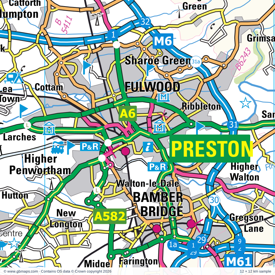
Explore the full 60 × 60 km Preston regional road map at 1:250,000, covering Preston, Manchester, Liverpool, Leyland, Horwich. Compare the complete coverage below; a detailed PDF sample is available free.

PRESTON & SURROUNDING AREAREGIONAL ROAD MAP
60 × 60 km · Full map previewDownload the free SVG ↓

INSIDE THE FULL 60 × 60 KM MAP

Explore the Preston map area

1:250,000 cartography

Towns, villages & places

More mapped places (213)

Roads across this sheet

M6, M55, M57, M58, M60, M61, M62, M65, M66, M602, A6, A34, A41, A49, A50, A56, A57, A57(M), A58, A59, A62, A506, A507, A526

More road numbers

A551, A554, A560, A565, A566, A567, A569, A570, A571, A572, A573, A574, A575, A576, A577, A578, A579, A580, A581, A582, A583, A584, A585, A586, A587, A588, A599, A626, A627(M), A635, A640, A646, A662, A663, A664, A665, A666, A667, A669, A671, A673, A674, A675, A676, A677, A678, A679, A680, A681, A682, A5014, A5027, A5028, A5030, A5036, A5038, A5039, A5040, A5044, A5046, A5047, A5048, A5049, A5050, A5053, A5054, A5055, A5056, A5058, A5062, A5063, A5066, A5067, A5068, A5071, A5072, A5073, A5079, A5080, A5081, A5082, A5083, A5085, A5088, A5089, A5090, A5098, A5099, A5103, A5106, A5139, A5145, A5147, A5181, A5184, A5185, A5186, A5207, A5208, A5209, A5230, A5267, A5758, A6010, A6027, A6041, A6042, A6044, A6045, A6046, A6047, A6053, A6060, A6061, A6062, A6063, A6066, A6068, A6077, A6078, A6099, A6104, A6114, A6119, A6143, A6144, A6145, A6185, B545, B5093, B5095, B5117, B5124, B5142, B5143, B5145, B5158, B5165, B5166, B5167, B5169, B5178, B5179, B5186, B5187, B5188, B5189, B5192, B5193, B5194, B5195, B5197, B5198, B5199, B5200, B5201, B5202, B5203, B5204, B5205, B5206, B5207, B5208, B5209, B5210, B5211, B5212, B5213, B5214, B5215, B5217, B5218, B5219, B5224, B5228, B5229, B5230, B5231, B5232, B5233, B5235, B5236, B5237, B5238, B5239, B5240, B5241, B5242, B5243, B5244, B5245, B5246, B5247, B5248, B5249, B5250, B5251, B5252, B5253, B5254, B5256, B5257, B5258, B5259, B5260, B5261, B5262, B5263, B5264, B5265, B5266, B5267, B5268, B5269, B5270, B5272, B5276, B5280, B5293, B5311, B5312, B5318, B5319, B5320, B5339, B5375, B5376, B5377, B5390, B5397, B5407, B5408, B5409, B5410, B5411, B5412, B5413, B5419, B5421, B5422, B5424, B5439, B5471, B6130, B6167, B6178, B6180, B6186, B6187, B6189, B6195, B6196, B6198, B6199, B6202, B6203, B6204, B6205, B6206, B6207, B6208, B6209, B6212, B6213, B6214, B6215, B6216, B6218, B6219, B6221, B6222, B6223, B6224, B6226, B6227, B6228, B6229, B6230, B6231, B6232, B6234, B6235, B6236, B6237, B6238, B6239, B6240, B6241, B6242, B6243, B6244, B6245, B6246, B6247, B6248, B6249, B6250, B6251, B6252, B6258, B6266, B6292, B6377, B6383, B6391, B6393, B6402, B6430, B6434, B6447, B6452, B6469, B6472, B6473, B6478, B6527, B6535, B6536
Rivers & waterways

Ashton Canal, Bridgewater Canal, Canal, Lancaster Canal, Leeds & Liverpool Canal, Leeds & Liverpool Canal (Walton Summit Branch), Manchester Ship Canal, Manchester, Bolton & Bury Canal (disused), Manchester, Bolton and Bury Canal (disused), Millennium Ribble Link, River Alt, River Brock

More waterways

River Calder, River Darwen, River Douglas, River Hodder, River Irwell, River Mersey, River Ribble, River Roch, River Tame, River Wyre, River Yarrow, Rochdale Canal, Sabden Brook, Tosside Beck

Landmarks & landscape

Abbey, Acorn Venture Urban Farm, Aintree Racecourse, Animal World, Astley Green Colliery Museum, Astley Hall, Bacup Museum, Bancroft Mill, Bath House, Beacon Country Park, Beacon Fell Country Park, Beacon Fell Country Park Visitor Centre

More named features

Belle Vue Stadium, Blackburn Cathedral, Blackleach Country Park & Visitor Centre, Blackpool Pleasure Beach, Blackpool Tower, Blackpool Tramway, Blackpool Zoo, Boggart Hole Clough Visitor Centre, Bolton Aquarium, Bolton Museum, Art Gallery, Aquarium, Botanic Gardens Museum, British Lawnmower Museum, Brockholes Visitor Centre, Browsholme Hall, Burrs Country Park, Chipping Wild Boar Park, Chorlton Water Park, Chorlton Water Sports, Chorlton Water Park (Fishing), City of Manchester Stadium, Egerton Narrow Boats, The Manchester Evening News Arena, Chetham's Library, National Cycling Centre, Clifton Country Park, Clifton Country Park Visitor Centre, Wet Earth Colliery, Clitheroe Castle, Clitheroe Castle Museum, Clock Face Country Park, Clough Head Visitor Centre, Cobble Hey Farm and Gardens, Cromwells Bridge, Croxteth Country Park, Croxteth Hall, Croxteth Home Farm, Jungle Parc Activity Centre, Cuerden Valley Park, Dewlay Cheese, East Lancashire Railway, Eccles Farm Craft Centre, Esplanade Arts and Heritage Centre, Touchstones Rochdale, Farmer Parrs Rare Breeds Farm, Farmer Ted's Farm Park, Fletcher Moss Botanical and Parsonage Gardens, Foulridge Wharf, Freeport Outlet Village, Gallery of English Costume, Gawthorpe Hall, Go Ape Rivington, Goodshaw Chapel, Gulliver's (Warrington), Haigh Country Park, Hall, Hall i'th Wood, Harris Museum and Art Gallery, The Football Museum Deepdale Preston, Yeomanry and County Museum, Haworth Art Galleries, Haydock Park Racecourse, Healey Dell Nature Reserve, Heaton Hall, Heaton Park, Heaton Park Animal Centre, Heaton Park Tram Museum, Helmshore Textile Museum, Hoghton Tower, Horwich Heritage Centre, Imperial War Museum North, Jacinta Trawler Museum, Jumbles Country Park, Knowsley Hall, Knowsley Safari Park, Lancashire Fusiliers Regimental Museum, Bury Art Gallery and Museum, Bury Transport Museum, Lancaster Park Animal Farm, Leisure Lakes, Lewes Garden Nature Reserve, Lewis Textile Museum & Blackburn Museum & Art Gallery, Liverpool FC Museum and Tour Centre, Liverpool Museum, Western Approaches Museum, Conservation Centre, Planetarium, Victoria Gallery and Museum, Liverpool-Maritime Mercantile City (World Heritage Site), Longton Brickcroft Nature Reserve, Longton Brickcroft Nature Reserve Visitor Centre, Lytham Hall, Lytham St Anne's Local Nature Reserve, Manchester C of E Cathedral, Manchester City Art Gallery, Museum of Science & Industry, The Pump House (Peoples History Museum), Manchester Swimming Complex, Manchester United Museum, Ordsall Hall Museum, Marsh Mill, Marshside Nature Reserve, Martin Mere Nature Reserve, Megabowl Bowling Alley, Mere Sands Wood Nature Reserve, Mersey Valley Visitor Centre, Cloverfield Riding Centre, Metropolitan Cathedral, Liverpool Cathedral, Moses Gate Country Park, Mrs Dowsons Ice Cream, Museum of Queen's Lancashire, Museum of Transport, Manchester Jewish Museum, Urbis, National Wildflower Centre, Nelson Pit Visitor Centre, New Pleasureland, North West Museum of Road Transport, World of Glass, Orrell Water Park, Oswaldtwistle Mills, Peel Tower, Pennington Flash Country Park, Pennington Flash Country Park Visitor Centre, Perch Rock (Beauty Spot), Planet Earth Centre, Platform 4 Model Transport Museum, Platform Gallery, Pleasington Nature Reserve, Prescot Museum, Queen Street Mill, Ramsbottom Heritage Gallery, Ribble Discovery Centre, Fairhaven Lake, Ribble Steam Railway, Ribchester Roman Museum, Rice Lane City Farm, Rimrose Valley Country Park, Risley Moss Nature Park, Rivington Country Park, Rixton Claypits Nature Reserve, Rochdale Pioneers Museum, Greater Manchester Fire Service Museum, Roddlesworth Visitor Centre, Rossendale Museum, Rufford Old Hall, Sale Water Park, Salford Art Gallery and Museum, Viewpoint Photography Gallery, Samlesbury Hall, Sankey Valley Country Park Visitor Centre, Sankey Valley Park, Sawley Abbey, Smithhills Open Farm, Smithills Country Park, Smithills Hall, South Ribble Museum and Exhibition Centre, The British Commercial Vehicle Museum, Southport Model Railway Village, Spaceport, Stadt Moers Country Park, Stonyhurst College, Stonyhurst College Garden, Story of Scouting Museum, Sunnyhurst Wood Visitor Centre, Textile Museum, The Corgi Heritage Centre, The Dolls House and Fleetwood Museum, The Last Drop Village, The Manchester Museum, Pankhurst Centre, Whitworth Art Gallery, The Singing Ringing Tree, The Theatre Organ Heritage Centre, The Walker, FACT, University of Liverpool Art Gallery, Open Eye Gallery, The Way We Were Heritage Centre, Opie's Museum of Memories, Wigan Life, The Weavers Triangle Visitor Centre, The West Lancashire Light Railway, The Whitworth Museum, Three Sisters Racing Circuit, Tower, Towneley Hall, Trafford Park Heritage Centre, HMS Bronington, The Lowry, Turton Tower, Visitor Centre, Walley Abbey Visitor Centre, Warrington Indoor Tennis Centre, Water Ski Centre, Weavers Cottage, Lamberts Mill Footwear Museum, Wellybobs, Whalley Abbey Gatehouse, Wigan Pier, Windmill Farm (Animal Farm), Windmill Museum, Lytham Lifeboat Museum, Lytham Heritage Centre, Witton Park Country Park, Worden Park, Wyre Estuary Country Park, Wyreside Ecology Centre, Yarrow Valley Park Country Park, Yarrow Valley Visitor Centre

Local authority & parish coverage

Wholly or partly within the full map rectangle. These boundaries are coverage information, not additional artwork layers.

  • Blackburn with DarwenWholly within
  • BlackpoolPartly within
  • Bolton DistrictWholly within
  • Burnley DistrictPartly within
  • Bury DistrictWholly within
  • Calderdale DistrictPartly within
  • Chorley DistrictWholly within
  • Fylde DistrictPartly within
  • Hyndburn DistrictWholly within
  • Knowsley DistrictPartly within
  • Lancaster DistrictPartly within
  • Liverpool DistrictPartly within
  • Manchester DistrictPartly within
  • North YorkshirePartly within
  • Oldham DistrictPartly within
  • Pendle DistrictPartly within
  • Preston DistrictWholly within
  • Ribble Valley DistrictPartly within
  • Rochdale DistrictPartly within
  • Rossendale DistrictPartly within
  • Salford DistrictWholly within
  • Sefton DistrictPartly within
  • South Ribble DistrictWholly within
  • St. Helens DistrictPartly within
  • Stockport DistrictPartly within
  • Tameside DistrictPartly within
  • Trafford DistrictPartly within
  • WarringtonPartly within
  • West Lancashire DistrictPartly within
  • Wigan DistrictWholly within
  • Wirral DistrictPartly within
  • Wyre DistrictPartly within
Wards & electoral divisions 502 areas
  • Abram Ward
  • Adlington & Anderton Ward
  • Ainsdale Ward (part)
  • Aintree & Maghull South Ward
  • Alston & Hothersall Ward
  • Altham Ward
  • Anchorsholme Ward
  • Ancoats & Beswick Ward
  • Anfield Ward
  • Ansdell & Fairhaven Ward
  • Ardwick Ward
  • Ashton Ward
  • Ashton Ward
  • Ashton upon Mersey Ward
  • Ashton-in-Makerfield South Ward
  • Aspull, New Springs & Whelley Ward
  • Astley Bridge Ward
  • Astley Ward
  • Atherton North Ward
  • Atherton South & Lilford Ward
  • Audenshaw Ward (part)
  • Audley & Queen's Park Ward
  • Aughton & Holborn Ward
  • Bacup Ward
  • Balderstone & Kirkholt Ward (part)
  • Bamber Bridge East Ward
  • Bamber Bridge West Ward
  • Bamford Ward
  • Bank Hall Ward
  • Barnfield Ward
  • Barnoldswick Ward (part)
  • Barrowford & Pendleside Ward
  • Barton & Winton Ward
  • Bastwell & Daisyfield Ward
  • Baxenden Ward
  • Besses Ward
  • Bewsey & Whitecross Ward (part)
  • Bidston and St. James Ward (part)
  • Billinge & Beardwood Ward
  • Billinge & Seneley Green Ward
  • Billington & Langho Ward
  • Birchwood Ward
  • Birkdale Ward
  • Bispham Ward
  • Blackbrook Ward
  • Blackburn Central Ward
  • Blackburn South & Lower Darwen Ward
  • Blackburn South East Ward
  • Blackfriars & Trinity Ward
  • Bloomfield Ward (part)
  • Blundellsands Ward (part)
  • Bold & Lea Green Ward (part)
  • Boothstown & Ellenbrook Ward
  • Bootle East Ward
  • Bootle West Ward
  • Boulsworth & Foulridge Ward (part)
  • Bourne Ward
  • Bowdon Ward (part)
  • Bowland Ward (part)
  • Bradley Ward
  • Bradshaw Ward
  • Breck Ward
  • Breightmet Ward
  • Briercliffe Ward (part)
  • Brierfield East & Clover Hill Ward
  • Brierfield West & Reedley Ward
  • Brinnington & Stockport Central Ward (part)
  • Britannia & Lee Mill Ward
  • Broad Oak Ward
  • Broadfield Ward
  • Broadgreen Ward
  • Broadheath Ward (part)
  • Brock with Catterall Ward
  • Brockhall & Dinckley Ward
  • Bromley Cross Ward
  • Brookfield Ward
  • Brooklands Ward (part)
  • Brooklands Ward
  • Broughton Ward
  • Brownlow Hill Ward
  • Brunshaw Ward
  • Brunswick Ward
  • Bryn with Ashton-in-Makerfield North Ward
  • Bucklow-St. Martins Ward
  • Buckshaw & Whittle Ward
  • Buckshaw & Worden Ward
  • Burnage Ward
  • Burscough Bridge & Rufford Ward
  • Burscough Town Ward
  • Burtonwood & Winwick Ward
  • Bury East Ward
  • Bury West Ward
  • Cadishead & Lower Irlam Ward
  • Cadley Ward
  • Calder Ward
  • Cambridge Ward (part)
  • Canning Ward (part)
  • Carleton Ward
  • Carnegie Ward (part)
  • Castleton Ward (part)
  • Central Rochdale Ward (part)
  • Central Ward
  • Chadderton Central Ward (part)
  • Chadderton North Ward (part)
  • Chadderton South Ward (part)
  • Chapelford & Old Hall Ward (part)
  • Charlestown Ward
  • Charnock Ward
  • Chatburn Ward
  • Cheadle East & Cheadle Hulme North Ward (part)
  • Cheetham Ward
  • Cherryfield Ward
  • Childwall Ward (part)
  • Chipping Ward (part)
  • Chorley East Ward
  • Chorley North & Astley Ward
  • Chorley North East Ward
  • Chorley North West Ward
  • Chorley South East & Heath Charnock Ward
  • Chorley South West Ward
  • Chorlton Park Ward
  • Chorlton Ward
  • Church Ward
  • City Centre North Ward (part)
  • City Centre South Ward (part)
  • City Centre Ward
  • Claremont Ward
  • Claremont Ward (part)
  • Clayton & Openshaw Ward (part)
  • Clayton East, Brindle & Hoghton Ward
  • Clayton West & Cuerden Ward
  • Clayton-le-Dale & Salesbury Ward
  • Clayton-le-Moors Ward
  • Cleveleys Park Ward
  • Clifton Ward
  • Cliviger with Worsthorne Ward (part)
  • Clubmoor East Ward
  • Clubmoor West Ward
  • Coal Clough with Deerplay Ward
  • Coppull Ward
  • County Ward
  • Coupe Green & Gregson Lane Ward
  • Croston, Mawdesley & Euxton South Ward
  • Croxteth Country Park Ward
  • Croxteth Ward
  • Crumpsall Ward
  • Culcheth, Glazebury & Croft Ward
  • Daneshouse with Stoneyholme Ward
  • Darwen East Ward
  • Darwen South Ward
  • Darwen West Ward
  • Davyhulme Ward
  • Deansgate Ward
  • Deepdale Ward
  • Denton West Ward (part)
  • Derby & Thornley Ward
  • Didsbury East Ward (part)
  • Didsbury West Ward
  • Dilworth Ward
  • Douglas Ward
  • Droylsden East Ward (part)
  • Droylsden West Ward (part)
  • Duke's Ward (part)
  • Earby & Coates Ward (part)
  • Earnshaw Bridge Ward
  • East Middleton Ward
  • East Whalley, Read & Simonstone Ward
  • Eccles Ward
  • Eccleston Ward
  • Eccleston, Heskin & Charnock Richard Ward
  • Edge Hill Ward (part)
  • Edgeley Ward (part)
  • Edisford & Low Moor Ward
  • Ellel Ward (part)
  • Elton Ward
  • Euxton Ward
  • Everton East Ward
  • Everton North Ward
  • Everton West Ward
  • Ewood Ward
  • Failsworth East Ward (part)
  • Failsworth West Ward (part)
  • Fallowfield Ward
  • Farington East Ward
  • Farington West Ward
  • Farnworth North Ward
  • Farnworth South Ward
  • Fazakerley East Ward
  • Fazakerley North Ward
  • Fazakerley West Ward
  • Fence & Higham Ward
  • Fishwick & Frenchwood Ward
  • Flixton Ward
  • Ford Ward
  • Formby East Ward (part)
  • Formby West Ward (part)
  • Freckleton Village Ward
  • Gannow Ward
  • Garrison Ward
  • Garstang Ward
  • Gawthorpe Ward
  • Gisburn & Rimington Ward (part)
  • Golborne & Lowton West Ward
  • Goodshaw & Cribden Ward
  • Gorse Hill & Cornbrook Ward
  • Gorton & Abbey Hey Ward (part)
  • Great Crosby Ward
  • Great Eccleston Ward
  • Great Lever Ward
  • Great Sankey North & Whittle Hall Ward (part)
  • Greenfield & Eden Ward
  • Greenlands Ward
  • Greyfriars Ward
  • Halliwell Ward
  • Hambleton & Stalmine Ward
  • Hapton with Park Ward
  • Hardhorn with High Cross Ward
  • Hareholme & Waterfoot Ward
  • Harpurhey Ward
  • Haslingden Ward
  • Hawes Side Ward
  • Haydock Ward
  • Healey Ward (part)
  • Heaton, Lostock & Chew Moor Ward
  • Heatons North Ward
  • Heatons South Ward (part)
  • Helmshore Ward
  • Heyhouses Ward
  • Higher Blackley Ward
  • Higher Irlam & Peel Green Ward
  • Highfield Ward
  • Hindley Green Ward
  • Hindley Ward
  • Holyrood Ward
  • Hoole Ward
  • Hopwood Hall Ward
  • Horwich North Ward
  • Horwich South & Blackrod Ward
  • Howick & Priory Ward
  • Hulme Ward
  • Hulton Ward
  • Huncoat Ward
  • Hurst Green & Whitewell Ward (part)
  • Immanuel Ward
  • Ince Ward
  • Ingol & Cottam Ward
  • Ingthorpe Ward
  • Jubilee Ward
  • Kearsley Ward
  • Kensington & Fairfield Ward
  • Kersal & Broughton Park Ward
  • Kew Ward
  • Kilgrimol Ward (part)
  • Kilnhouse Ward
  • Kirkdale East Ward
  • Kirkdale West Ward
  • Kirkham Ward
  • Knotty Ash & Dovecot Park Ward
  • Lanehead Ward
  • Layton Ward
  • Lea & Larches Ward
  • Leigh Central & Higher Folds Ward
  • Leigh South Ward
  • Leigh West Ward
  • Levenshulme Ward
  • Leyland Central Ward
  • Liscard Ward (part)
  • Litherland Ward
  • Little Harwood & Whitebirk Ward
  • Little Hulton Ward
  • Little Lever & Darcy Lever Ward
  • Littlemoor Ward
  • Livesey with Pleasington Ward
  • Longford Ward
  • Longholme Ward
  • Longsight Ward
  • Longton & Hutton West Ward
  • Lostock & Barton Ward
  • Lostock Hall Ward
  • Lowton East Ward
  • Lydiate & Maghull West Ward
  • Lytham East Ward
  • Lytham West Ward
  • Maghull East Ward
  • Manor Ward
  • Marsden & Southfield Ward (part)
  • Marsh Mill Ward
  • Marton Ward
  • Medlar-with-Wesham Ward
  • Mellor Ward
  • Meols Ward
  • Middleforth Ward
  • Miles Platting & Newton Heath Ward
  • Milkstone & Deeplish Ward (part)
  • Mill Hill & Moorgate Ward
  • Milnshaw Ward
  • Moorside Ward
  • Moss Bank Ward
  • Moss Side Ward
  • Moss Side Ward
  • Moston Ward
  • Mount Ward
  • Netherton North Ward
  • Netherton South & Orrell Ward
  • Netherton Ward
  • New Brighton Ward (part)
  • New Longton & Hutton East Ward
  • Newton-le-Willows East Ward
  • Newton-le-Willows West Ward
  • Norbreck Ward
  • Norden Ward
  • Norris Green Ward
  • North Heywood Ward
  • North Manor Ward
  • North Meols & Hesketh Bank Ward (part)
  • North Middleton Ward (part)
  • Northenden Ward (part)
  • Northwood Ward
  • Norwood Ward
  • Old Moat Ward
  • Old Skelmersdale Ward
  • Old Swan East Ward
  • Old Swan West Ward
  • Old Trafford Ward
  • Ordsall Ward
  • Orford Ward (part)
  • Ormskirk East Ward
  • Ormskirk West Ward
  • Orrell Park Ward
  • Orrell Ward
  • Overton Ward
  • Page Moss Ward
  • Park Ward
  • Park Ward
  • Park Ward
  • Parr Ward
  • Peasley Cross & Fingerpost Ward
  • Peel Ward
  • Pemberton Ward
  • Pendlebury & Clifton Ward
  • Pendleton & Charlestown Ward
  • Pharos Ward (part)
  • Pheasant's Wood Ward
  • Piccadilly Ward
  • Pilkington Park Ward
  • Pilling Ward (part)
  • Plungington Ward
  • Poplars & Hulme Ward (part)
  • Poulton North Ward (part)
  • Poulton South Ward (part)
  • Preesall Ward (part)
  • Prescot North Ward
  • Prescot South Ward
  • Preston Rural East Ward
  • Preston Rural North Ward
  • Primrose Ward
  • Quays Ward
  • Queens Park & Central Ward
  • Queensgate Ward
  • Radcliffe East Ward
  • Radcliffe North & Ainsworth Ward
  • Radcliffe West Ward
  • Rainford Ward
  • Rainhill Ward (part)
  • Ramsbottom Ward
  • Reddish North Ward (part)
  • Reddish South Ward (part)
  • Redvales Ward
  • Ribbleton Ward
  • Ribchester Ward
  • Rishton Ward
  • Rixton & Woolston Ward (part)
  • Roby Ward (part)
  • Roe Lee Ward
  • Rosegrove with Lowerhouse Ward
  • Rosehill with Burnley Wood Ward
  • Rossall Ward
  • Royton North Ward (part)
  • Rumworth Ward
  • Rural East Fylde Ward
  • Rural North East Ward
  • Rural North Fylde Ward
  • Rural South Ward
  • Rural West Ward
  • Rusholme Ward
  • Sabden Ward
  • Sale Central Ward
  • Sale Moor Ward
  • Salthill Ward
  • Samlesbury & Walton Ward
  • Sandfield Park Ward
  • Seacombe Ward (part)
  • Sedgley Ward
  • Seven Stars Ward
  • Sharoe Green Ward
  • Shear Brow & Corporation Park Ward
  • Shevington Ward
  • Shevington with Lower Ground & Moor Ward
  • Skelmersdale North Ward
  • Skelmersdale South Ward
  • Smithdown Ward (part)
  • Smithills Ward
  • South Middleton Ward
  • Spotland & Falinge Ward
  • Spring Hill Ward
  • Squires Gate Ward (part)
  • St Mary's Ward
  • St. Ambrose Ward
  • St. Andrew's Ward
  • St. Gabriels Ward (part)
  • St. Helens Town Centre Ward
  • St. Mary's Ward
  • St. Matthew's Ward
  • St. Michaels Ward
  • St. Oswald's Ward
  • Staining Ward
  • Stanah Ward
  • Standish with Langtree Ward
  • Stanley Ward
  • Stockbridge Ward
  • Stoneycroft Ward
  • Stretford & Humphrey Park Ward
  • Sutton North West Ward
  • Sutton South East Ward
  • Swanside Ward
  • Swinton & Wardley Ward
  • Swinton Park Ward
  • Talbot Ward (part)
  • Tanhouse & Skelmersdale Town Centre Ward
  • Tarleton Village Ward
  • Thatto Heath Ward
  • Thornton & Hightown Ward (part)
  • Timperley North Ward (part)
  • Tithebarn Ward
  • Todmorden West Ward (part)
  • Tonge with the Haulgh Ward
  • Tottington Ward
  • Trinity Ward
  • Tuebrook Breckside Park Ward
  • Tuebrook Larkhill Ward
  • Tyldesley & Mosley Common Ward
  • Tyldesley Ward
  • Unsworth Ward
  • Up Holland Ward
  • Urmston Ward
  • Vauxhall Ward
  • Victoria & Norcross Ward
  • Victoria Ward
  • Vivary Bridge Ward
  • Waddington, Bashall Eaves & Mitton Ward
  • Walkden North Ward
  • Walkden South Ward
  • Wallasey Ward (part)
  • Walton Ward
  • Walton-le-Dale East Ward
  • Walton-le-Dale West Ward
  • Warbreck Ward (part)
  • Wardle, Shore & West Littleborough Ward (part)
  • Warren Ward (part)
  • Warton Ward
  • Waterfront North Ward
  • Waterfront South Ward (part)
  • Waterloo Ward
  • Waterloo Ward (part)
  • Waterside & Horsfield Ward (part)
  • Wavertree Garden Suburb Ward (part)
  • Wavertree Village Ward (part)
  • Weaste & Seedley Ward
  • Wensley Fold Ward
  • West Bradford & Grindleton Ward (part)
  • West Derby Deysbrook Ward
  • West Derby Leyfield Ward
  • West Derby Muirhead Ward
  • West Heywood Ward
  • West Middleton Ward
  • West Park Ward
  • West Pennine Ward
  • Westbrook Ward (part)
  • Westhoughton North & Hunger Hill Ward
  • Westhoughton South Ward
  • Whalley & Painter Wood Ward
  • Whalley Nethertown Ward
  • Whalley Range Ward
  • Whiston & Cronton Ward (part)
  • Whitefield & Walverden Ward
  • Whitefield Ward
  • Whitewell & Stacksteads Ward
  • Whittlefield with Ightenhill Ward
  • Whitworth Ward (part)
  • Wigan Central Ward
  • Wigan West Ward
  • Wilpshire & Ramsgreave Ward
  • Windle Ward
  • Winstanley Ward
  • Wiswell & Barrow Ward
  • Withington Ward
  • Worsley & Westwood Park Ward
  • Worsley Mesnes Ward
  • Wrea Green with Westby Ward
  • Wyresdale Ward (part)
  • Yew Tree Ward
  • Skipton West & West Craven ED (part)
Civil parishes & communities 223 areas
  • Adlington CP
  • Aighton, Bailey and Chaigley CP
  • Aintree Village CP
  • Altham CP
  • Anderton CP
  • Anglezarke CP
  • Ansdell CP
  • Astley Village CP
  • Aughton CP
  • Balderstone CP
  • Barley-with-Wheatley Booth CP
  • Barnacre-with-Bonds CP
  • Barnoldswick CP (part)
  • Barrow CP
  • Barrowford CP
  • Barton CP
  • Bashall Eaves CP
  • Bickerstaffe CP
  • Billinge Chapel End CP
  • Billington and Langho CP
  • Birchwood CP
  • Bispham CP
  • Blacko CP
  • Blackrod CP
  • Bleasdale CP (part)
  • Bold CP (part)
  • Bolton-by-Bowland CP (part)
  • Bowland Forest High CP (part)
  • Bowland Forest Low CP (part)
  • Bowland-with-Leagram CP
  • Bretherton CP
  • Briercliffe CP (part)
  • Brierfield CP
  • Brindle CP
  • Broughton CP
  • Bryning-with-Warton CP
  • Burscough CP
  • Burtonwood and Westbrook CP (part)
  • Cabus CP
  • Carrington CP
  • Catterall CP
  • Charnock Richard CP
  • Chatburn CP
  • Chipping CP
  • Claughton CP
  • Clayton-le-Dale CP
  • Clayton-le-Woods CP
  • Clitheroe CP
  • Cliviger CP (part)
  • Cockerham CP (part)
  • Colne CP (part)
  • Coppull CP
  • Croft CP
  • Croston CP
  • Cuerdale CP
  • Cuerden CP
  • Culcheth and Glazebury CP
  • Dalton CP
  • Darwen CP
  • Dinckley CP
  • Downham CP
  • Downholland CP
  • Dunham Massey CP (part)
  • Dunnockshaw CP
  • Dutton CP
  • Earby CP (part)
  • Eccleshill CP
  • Eccleston CP
  • Eccleston CP
  • Elswick CP
  • Euxton CP
  • Farington CP
  • Fleetwood CP (part)
  • Formby CP (part)
  • Forton CP (part)
  • Foulridge CP (part)
  • Freckleton CP
  • Garstang CP
  • Gisburn CP
  • Goldshaw Booth CP
  • Goosnargh CP
  • Great Altcar CP
  • Great Eccleston CP
  • Great Mitton CP
  • Great Sankey CP (part)
  • Greenhalgh-with-Thistleton CP
  • Grimsargh CP
  • Grindleton CP (part)
  • Habergham Eaves CP
  • Haigh CP
  • Haighton CP
  • Halsall CP
  • Hambleton CP
  • Hapton CP
  • Heapey CP
  • Heath Charnock CP
  • Hesketh-with-Becconsall CP
  • Heskin CP
  • Higham-with-West Close Booth CP
  • Hightown CP (part)
  • Hilldale CP
  • Hoghton CP
  • Horton CP (part)
  • Horwich CP
  • Hothersall CP
  • Hutton CP
  • Ightenhill CP
  • Ince Blundell CP (part)
  • Ingol and Tanterton CP
  • Inskip-with-Sowerby CP
  • Kelbrook and Sough CP (part)
  • Kirkham CP
  • Kirkland CP
  • Knowsley CP
  • Lathom CP
  • Lathom South CP
  • Lea CP
  • Little Altcar CP (part)
  • Little Eccleston-with-Larbreck CP
  • Little Hoole CP
  • Little Mitton CP
  • Livesey CP
  • Longridge CP
  • Longton CP
  • Lydiate CP
  • Lytham CP
  • Maghull CP
  • Martons Both CP (part)
  • Mawdesley CP
  • Mearley CP
  • Medlar-with-Wesham CP
  • Melling CP
  • Mellor CP
  • Middop CP
  • Much Hoole CP
  • Myerscough and Bilsborrow CP
  • Nateby CP
  • Nelson CP (part)
  • Nether Wyresdale CP (part)
  • Newburgh CP
  • Newton CP (part)
  • Newton-with-Clifton CP
  • North Meols CP (part)
  • North Turton CP
  • Old Laund Booth CP
  • Osbaldeston CP
  • Out Rawcliffe CP
  • Over Wyresdale CP (part)
  • Padiham CP
  • Parbold CP
  • Partington CP
  • Paythorne CP (part)
  • Pendleton CP
  • Penwortham CP
  • Pilling CP (part)
  • Pleasington CP
  • Poulton-with-Fearnhead CP (part)
  • Preesall CP (part)
  • Prescot CP
  • Rainford CP
  • Rainhill CP (part)
  • Ramsgreave CP
  • Read CP
  • Reedley Hallows CP
  • Ribby-with-Wrea CP
  • Ribchester CP
  • Rimington CP
  • Rivington CP
  • Rixton-with-Glazebrook CP (part)
  • Roughlee Booth CP
  • Rufford CP
  • Sabden CP
  • Saint Anne's on the Sea CP (part)
  • Salesbury CP
  • Salterforth CP (part)
  • Samlesbury CP
  • Sawley CP
  • Scarisbrick CP
  • Sefton CP
  • Seneley Green CP
  • Shevington CP
  • Simonstone CP
  • Simonswood CP
  • Singleton CP
  • Staining CP
  • Stalmine-with-Staynall CP
  • Tarleton CP
  • Thornley-with-Wheatley CP
  • Thornton CP
  • Thornton in Craven CP (part)
  • Tockholes CP
  • Todmorden CP (part)
  • Trawden Forest CP (part)
  • Treales, Roseacre and Wharles CP
  • Twiston CP
  • Ulnes Walton CP
  • Up Holland CP
  • Upper Rawcliffe-with-Tarnacre CP
  • Waddington CP
  • Warburton CP (part)
  • Weeton-with-Preese CP
  • West Bradford CP
  • Westby-with-Plumptons CP
  • Westhoughton CP
  • Whalley CP
  • Wheelton CP
  • Whiston CP (part)
  • Whittingham CP
  • Whittle-le-Woods CP
  • Whitworth CP (part)
  • Wilpshire CP
  • Windle CP
  • Winmarleigh CP
  • Winwick CP
  • Wiswell CP
  • Withnell CP
  • Woodplumpton CP
  • Woolston CP (part)
  • Worsthorne-with-Hurstwood CP (part)
  • Worston CP
  • Worthington CP
  • Wrightington CP
  • Yate and Pickup Bank CP

Source: the GBMaps road atlas, OS Boundary-Line and postcode mapping datasets. Source editions are being checked for publication. Unmarked boundary names are wholly within the sheet; “part” means the map edge crosses the area.

Place lists are selected from the map source, not a complete gazetteer. Named features describe the cartography; visitor facilities and opening status are not verified. The free sample covers only 12 × 12 km of this larger sheet.

INSIDE YOUR DOWNLOAD

A proper road map, in useful formats

Road classifications, towns and villages, railways, rivers, landscape detail and tourist symbols, brought together in the GBMaps regional road atlas style.

PDF filePDFSVG fileSVGAdobe Illustrator AI fileAi

PDF for the finished map. SVG and layered Illustrator artwork for adapting colours, adding your own information and preparing designs.

THE FINISHED SHEET

Designed for print and presentation

Map coverage
60 × 60 km
Sample coverage
12 × 12 km
Print layout
A3 landscape · enlarged 1:250k cartography
Sheet furniture
Border, scale bar, key & north arrow

A few useful details

What changes when I select another square?

Select a surrounding square to bring it into the centre and reveal the maps around it. Each square is a different 60 × 60 km map. The preview, free sample and selected download change together. Neighbouring sheets overlap by 30 km so you can choose the coverage that suits you.

Is the free sample a vector map?

The on-page detail is an SVG. The free download is a separate 12 × 12 km PDF with a link to the full map. Please retain its copyright credits and product link when sharing it.

Can I buy a larger combined map?

These downloads are individual ready-made sheets. Contact GBMaps if you need a larger combined area.

FREE PDF SAMPLE

Your free map sample

Your free 12 × 12 km sample includes a link back to this map, so you can return for the full area whenever you need it.

Download free PDF sample ↓

Get your Preston map

Map download bundle

£24.00including VATOne payment

Pay securely

One payment. Your map stays open.

Your map download

Your map files

Preparing your download…

Checking your private download link…

Your map downloads

Already bought a map?

Find the downloads from your purchases.

Enter the email address you used at checkout. We’ll email you a private link to your available map downloads.