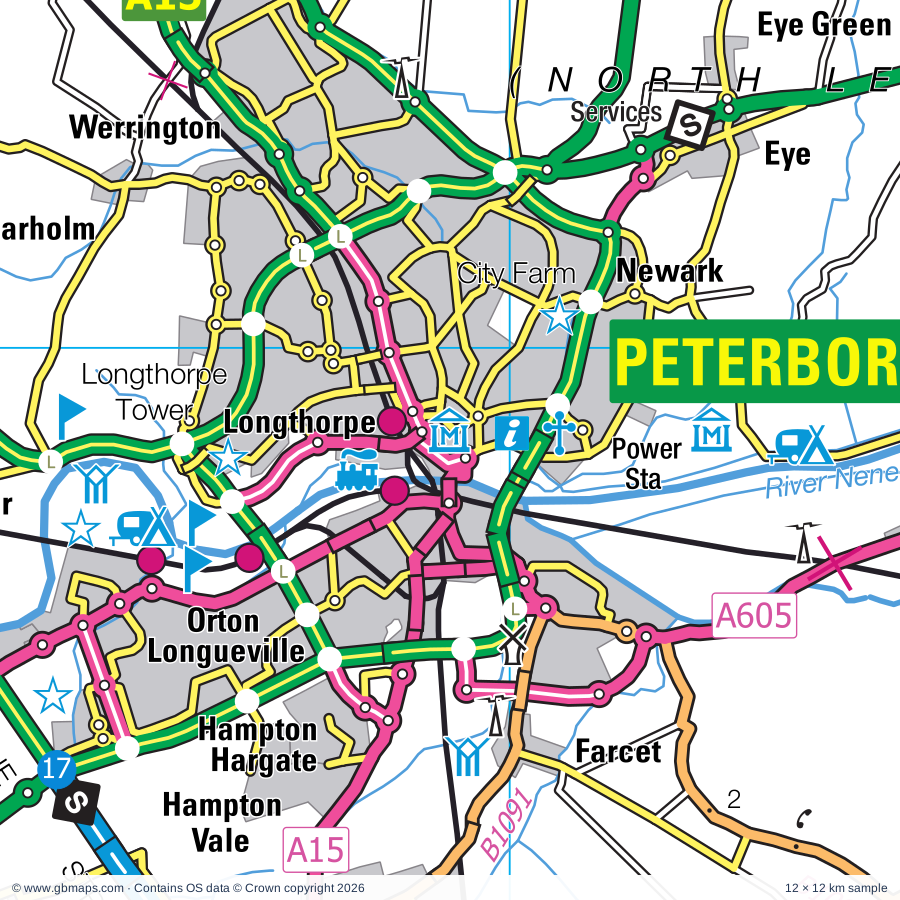
Peterborough regional road map. Full 60 × 60 km PDF, SVG and Illustrator files, with a free PDF sample.

GBMAPS.COM

Peterborough Regional Road Map

Call Us Now for Help01751 473136

GREAT BRITAIN ROAD ATLAS · 1:250,000 GB-510-0300

Peterborough & surrounding area

Explore the full 60 × 60 km Peterborough regional road map at 1:250,000, covering Stamford, Oundle, Crowland, Bourne, Uppingham. Compare the complete coverage below; a detailed PDF sample is available free.

PETERBOROUGH & SURROUNDING AREAREGIONAL ROAD MAP
60 × 60 km · Full map previewDownload the free SVG ↓

INSIDE THE FULL 60 × 60 KM MAP

Explore the Peterborough map area

1:250,000 cartography

Towns, villages & places

More mapped places (295)
  • Sutton
  • Ailsworth
  • Stibbington
  • Sibson
  • Wansford
  • Castor
  • Southorpe
  • Thornhaugh
  • Yarwell
  • Ufford
  • Nassington
  • Marholm
  • Wittering
  • Chesterton
  • Barnack
  • Ashton
  • Helpston
  • Bainton
  • Elton
  • Pilsgate
  • Etton
  • Fotheringhay
  • Tallington
  • Glinton
  • Haddon
  • Maxey
  • Woodnewton
  • Uffington
  • Wothorpe
  • Warmington
  • Morborne
  • Peakirk
  • Northborough
  • King's Cliffe
  • Tansor
  • Cotterstock
  • Collyweston
  • Barholm
  • Folksworth
  • Duddington
  • Southwick
  • Yaxley
  • Tinwell
  • Farcet
  • Belmesthorpe
  • Greatford
  • Newborough
  • Lutton
  • Stilton
  • Tixover
  • Frognall
  • Glapthorn
  • Caldecote
  • Ashton
  • Ryhall
  • Langtoft
  • Ketton
  • Denton
  • Eye
  • Polebrook
  • Braceborough
  • Great Casterton
  • Eye Green
  • Essendine
  • Wilsthorpe
  • Baston
  • Wakerley
  • Tickencote
  • Armston
  • Hemington
  • Glatton
  • Carlby
  • Bulwick
  • Holme
  • Barrowden
  • Laxton
  • Barnwell
  • Conington
  • Manthorpe
  • Deenethorpe
  • Hop Pole
  • Normanton
  • Thurlby
  • Thurning
  • Deene
  • Northorpe
  • Pickworth
  • Empingham
  • Morcott
  • North Side
  • Toft
  • Pilton
  • Sawtry
  • Pondersbridge
  • Edith Weston
  • Wigsthorpe
  • Little Gidding
  • Careby
  • Lound
  • Harringworth
  • Thorney
  • Wadenhoe
  • Achurch
  • Pilton
  • Winwick
  • Tongue End
  • Eastrea
  • Lyndon
  • Whitwell
  • Seaton
  • Little Bytham
  • Clopton
  • Weldon
  • Glaston
  • Aldwincle
  • Hamerton
  • Clipsham
  • Coates
  • Exton
  • Gretton
  • Thorpe by Water
  • Wing
  • Coppingford
  • Brigstock
  • Dowsdale
  • Twenty
  • Castle Bytham
  • Bisbrooke
  • Creeton
  • Titchmarsh
  • Stretton
  • Eldernell
  • Cawthorpe
  • Woodwalton
  • Sudborough
  • Edenham
  • Manton
  • Dyke
  • Greetham
  • Stanion
  • Lyddington
  • Upton
  • Lowick
  • Preston
  • Upwood
  • Egleton
  • Grimsthorpe
  • Turves
  • Buckworth
  • Brington
  • Caldecott
  • Ayston
  • Swinstead
  • Islip
  • Cottesmore
  • Morton
  • Cowbit
  • Hanthorpe
  • Elsthorpe
  • Molesworth
  • Stoke Dry
  • Burley
  • Bury
  • Bythorn
  • Rockingham
  • Wennington
  • Pode Hole
  • Barham
  • Ridlington
  • Stainfield
  • Holbeach Drove
  • Swayfield
  • Haconby
  • Keyston
  • Slipton
  • Alconbury
  • Denford
  • Brooke
  • Barrow
  • Thistleton
  • South Witham
  • Woolley
  • Wistow
  • Great Easton
  • Benwick
  • Gedney Hill
  • Twywell
  • Stockerston
  • Woodford
  • Bulby
  • Pinchbeck West
  • Wardley
  • Birkholme
  • Corby Glen
  • Catworth
  • Geddington
  • Throckenholt
  • Barleythorpe
  • Dunsby
  • Ashwell
  • Bringhurst
  • Ringstead
  • Spaldwick
  • Cottingham
  • Newton
  • Irnham
  • Rippingale
  • Northgate
  • Langham
  • Middleton
  • Hawthorpe
  • Drayton
  • Allexton
  • Murrow
  • Parson Drove
  • Teigh
  • Gunby
  • Broughton
  • Easton
  • Weekley
  • Warkton
  • Ellington
  • Warboys
  • Pinchbeck
  • Horninghold
  • Guyhirn
  • Colsterworth
  • Covington
  • Dowsby
  • Keisby
  • Graby
  • Westry
  • Blaston
  • Stainby
  • Hargrave
  • Ring's End
  • Pipewell
  • Fenton
  • Sewstern
  • Old Hurst
  • Cold Overton
  • Medbourne
  • Bitchfield
  • Wilbarston
  • Rushton
  • Knossington
  • Westby
  • Stanwick
  • Brampton
  • Doddington
  • Wymondham
  • Weston
  • Bassingthorpe
  • Easton
  • Buckminster
  • Moulton
  • Risegate
  • Surfleet
  • Woodhurst
  • Pidley
  • Skillington
  • Stoke Rochford
  • Houghton
  • Whaplode
  • Finedon
  • Coston
  • Loosegate
  • Rothwell
  • Isham
  • Garthorpe
  • Somersham
  • Saxby
  • Stapleford
  • Sproxton
  • Pytchley
  • Loddington
  • Holbeach
  • Orton
  • Freeby
  • Broughton
  • Colne
  • Saltby
  • Wyville
  • Orlingbury
  • Bluntisham
  • Needingworth
  • Stonesby
  • Fleet
  • Holywell
  • Earith
  • Fleet Hargate
  • Over
  • Walgrave
  • Hannington
  • Branston

Roads across this sheet

A1(M), A6, A14(M), A15, A16, A17, A43, A141, A142, A151, A152, A427, A509, A510, A605, A606, A607, A1096, A1123, A1139, A1175, A1179, A1198, A1260

More road numbers

A4086, A4300, A5028, A6003, A6013, A6014, A6098, A6116, A6118, A6121, A6900, B571, B574, B575, B576, B640, B641, B645, B660, B662, B663, B664, B668, B669, B670, B671, B672, B676, B1040, B1043, B1044, B1050, B1081, B1086, B1089, B1090, B1091, B1092, B1093, B1095, B1096, B1098, B1162, B1165, B1166, B1167, B1168, B1172, B1173, B1176, B1177, B1180, B1187, B1193, B1356, B1357, B1381, B1390, B1397, B1443, B1514, B1515, B1524, B1525, B5323, B5348, B6403, B6481

Rivers & waterways

Canal (disused), Cross Drain, East Glen River, Eye Brook, Forty Foot or Vermuden's Drain, Harper's Brook, King's Dike, New Bedford River or Hundred Foot Drain, New River, North Drove Drain, Old Bedford River, River Chater

More waterways

River Devon, River Eye, River Glen, River Great Ouse, River Gwash, River Ise, River Nene, River Nene ( old course ), River Welland, River Witham, South Drove Drain, South Forty Foot Drain, South Holland Main Drain, Twenty Foot River, Vernatt's Drain, West Glen River, Whaplode River, Whittlesey Dike

Landmarks & landscape

Abbey (remains of), Abbey Farm Solar Farm, Aversley Wood Nature Reserve, Ayscoughfee Hall, Ayscoughfee Hall, Gordon Boswell Romany Museum, Barnack Hills & Holes-BNR Nature Reserve, Barnsdale Gardens, Barnwell Country Park, Baytree Owl Centre, Fun Farm (Spalding), Bede House, Birchgrove Bulb Museum, Blacked-Out Britain War Museum, The Cromwell Museum

More named features

Boughton House, Brampton Wood Nature Reserve, Brooklands Farm Solar Farm, Browne's Hospital, Burghley House, Castle, Castor Hanglands National Nature Reserve, Chatteris Museum, Countryside Park, Cross, Crown Lakes Country, Croxton Park, Deene Park, Drayton House, Drought Garden and Arboretum, East Of England Showground, Easton Walled Gardens, Egleton Nature Reserve, Eleanor Cross, Elton Hall, Elton Hall and Garden, Fermyn Woods Country Park, Ferry Meadows Country Park, Ferry Meadows Visitor Centre, Five Archer's Nature Reserve, Flag Fen Museum, Fotheringhay Castle, Glendon Hall, Grays Honey Farm, Grimsthorpe Castle, Grimsthorpe Castle and Garden, Grimsthorpe Garden, Hamerton Zoo Park, Heritage Centre, Highgate Farm, Hinchingbrooke Country Park, Hinchingbrooke Country Park Visitor Centre, Hinchingbrooke House, Holme Fen National Nature Reserve, Holme Fen Posts lowest GB land point at 2.75m below sea level, Houghton Mill, Huntingdon Racecourse, Kirby Hall, Lattersey Nature Reserve, Lilford Hall, Longthorpe Tower, Lyveden New Bield, Manor House Museum, Maze In Maize, Melbourn Brothers Brewery, Stamford Arts Centre, Monks Wood Nature Reserve, Moulton Windmill, Museum of Technology, Nene Valley Railway, Nene Washes Nature Reserve (RSPB Reserve), New Ark Adventure Playground & City Farm, Oakham Castle, Oakham Castle (remains of), Oundle Museum, Peterborough Cathedral, Peterborough Museum and Art Gallery, Railworld Museum, Pigeons Farm, Pinchbeck Engine Museum of Land Drainage, Pingle Wood Cutting Nature Reserve, Prebendal Manor House, Priest's House, Ramsey Abbey Gatehouse, Ramsey Rural Museum, Rockingham Castle, Rockingham Castle and Gardens, Rockingham Motor Speedway Circuit, Rookery Farm Solar Farm, Rothwell Arts and Heritage Centre, Rushton Triangular Lodge, Ruston Triangular Lodge, Rutland County Museum, Rutland Falconry & Owl Centre, Rutland Open Air Theatre, Rutland Railway Museum, Rutland Water (North) Nature Reserve, Rutland Water Visitor Centre, Indoor Rock Climbing, Sacrewell Farm & Country Centre, Solar Farm, South Witham Nature Reserve, Southorpe Paddock Nature Reserve, Southwick Hall, St Ives Bridge Chapel, Stamford Castle, Stanwick Lakes Visitor Centre, Tallington Lakes Leisure Park, The Limekiln, The Lodge Visitor Centre, The Manor Gardens, The Norris Museum, The Pottery, The Raptor Foundation, Thorney Heritage Museum, Tolethorpe Hall, Trinity Bridge, Visitor Centre, Washbrook Farm Motocross Track, Weldon Woodland Country Park, West Lodge Rural Centre, Whittlesey Museum, Wicksteed Park, Wing Maze, Woodwalton Fen Nature Reserve, Woolsthorpe Manor (Birthplace of Newton), Wymondham Windmill
Local authority & parish coverage

Wholly or partly within the full map rectangle. These boundaries are coverage information, not additional artwork layers.

  • BedfordPartly within
  • City of PeterboroughWholly within
  • East Cambridgeshire DistrictPartly within
  • Fenland DistrictPartly within
  • Harborough DistrictPartly within
  • Huntingdonshire DistrictPartly within
  • Melton DistrictPartly within
  • North NorthamptonshirePartly within
  • RutlandPartly within
  • South Cambridgeshire DistrictPartly within
  • South Holland DistrictPartly within
  • South Kesteven DistrictPartly within
  • West NorthamptonshirePartly within
Wards & electoral divisions 140 areas
  • Alconbury Ward (part)
  • Aveland Ward (part)
  • Avondale Grange Ward
  • Barleythorpe Ward
  • Barnack Ward
  • Barton Seagrave & Burton Latimer Ward
  • Belvoir Ward (part)
  • Billesdon & Tilton Ward (part)
  • Bourne Austerby Ward
  • Bourne East Ward
  • Bourne West Ward
  • Brampton Ward (part)
  • Braunston & Martinsthorpe Ward (part)
  • Bretton Ward
  • Casewick Ward
  • Castle Ward
  • Central Ward
  • Chatteris North & Manea Ward (part)
  • Chatteris South Ward (part)
  • Corby West Ward
  • Cottesmore Ward
  • Crowland and Deeping St. Nicholas Ward
  • Croxton Kerrial Ward (part)
  • Deeping St. James Ward
  • Desborough Ward (part)
  • Doddington & Wimblington Ward (part)
  • Dogsthorpe Ward
  • Dole Wood Ward
  • Donington, Quadring and Gosberton Ward (part)
  • Earls Barton Ward (part)
  • East Ward
  • Elm & Christchurch Ward (part)
  • Exton Ward
  • Eye, Thorney & Newborough Ward
  • Fenstanton Ward (part)
  • Finedon Ward (part)
  • Fleet Ward (part)
  • Fletton & Stanground Ward
  • Fletton & Woodston Ward
  • Geddington & Stanion Ward
  • Gedney Ward (part)
  • Glen Ward
  • Glinton & Castor Ward
  • Godmanchester & Hemingford Abbots Ward (part)
  • Great Staughton Ward (part)
  • Greetham Ward
  • Gretton & Weldon Ward
  • Gunthorpe Ward
  • Haddenham Ward (part)
  • Hampton Vale Ward
  • Hargate & Hempsted Ward
  • Hatton Park Ward (part)
  • Hemingford Grey & Houghton Ward (part)
  • Higham Ferrers Ward (part)
  • Holbeach Hurn Ward (part)
  • Holbeach Town Ward
  • Holywell-cum-Needingworth Ward
  • Huntingdon East Ward
  • Huntingdon North Ward
  • Irthlingborough Ward (part)
  • Isaac Newton Ward (part)
  • Ise Ward
  • Kettering Central Ward
  • Kettering North Ward
  • Ketton Ward
  • Kimbolton Ward (part)
  • Kingswood Ward
  • Langham Ward
  • Leverington & Wisbech Rural Ward (part)
  • Lincrest Ward (part)
  • Lloyds & Corby Village Ward
  • Long Sutton Ward (part)
  • Lyddington Ward
  • March West & Benwick Ward (part)
  • Market & West Deeping Ward
  • Morton Ward
  • Moulton, Weston and Cowbit Ward (part)
  • Nevill Ward (part)
  • Normanton Ward
  • North Ward
  • Oakham North East Ward
  • Oakham North West Ward
  • Oakham South Ward
  • Oakley Ward
  • Orton Longueville Ward
  • Orton Waterville Ward
  • Oundle Ward
  • Over & Willingham Ward (part)
  • Park Ward
  • Parson Drove & Wisbech St. Mary Ward (part)
  • Paston & Walton Ward
  • Pinchbeck and Surfleet Ward (part)
  • Pipers Hill Ward
  • Ramsey Ward
  • Raunds Ward (part)
  • Ravensthorpe Ward
  • Riseley Ward (part)
  • Rothwell & Mawsley Ward (part)
  • Rural North East Ward (part)
  • Ryhall & Casterton Ward
  • Sawtry Ward
  • Somerby Ward (part)
  • Somersham Ward
  • Spalding Castle Ward
  • Spalding Monks House Ward
  • Spalding St. John's Ward
  • Spalding St. Mary's Ward
  • Spalding St. Paul's Ward
  • Spalding Wygate Ward
  • St. Ives East Ward
  • St. Ives South Ward (part)
  • St. Ives West Ward
  • St. Michael Ward
  • St. Peter Ward
  • Stamford All Saints Ward
  • Stamford St. George's Ward
  • Stamford St. John's Ward
  • Stamford St. Mary's Ward
  • Stanground South Ward
  • Stilton, Folksworth & Washingley Ward
  • Sutton Ward (part)
  • Swavesey Ward (part)
  • The Saints Ward (part)
  • The Stukeleys Ward
  • Thrapston Ward
  • Uppingham Ward
  • Victoria Ward (part)
  • Waltham-on-the-Wolds Ward (part)
  • Warboys Ward
  • Werrington Ward
  • West Ward
  • Whaplode and Holbeach St. John's Ward (part)
  • Whissendine Ward (part)
  • Whittlesey East & Villages Ward
  • Whittlesey Lattersey Ward
  • Whittlesey North West Ward
  • Whittlesey South Ward
  • Wittering Ward
  • Wymondham Ward (part)
  • Yaxley Ward
Civil parishes & communities 358 areas
  • Abbots Ripton CP
  • Ailsworth CP
  • Alconbury CP
  • Alconbury Weston CP
  • Aldwincle CP
  • Allexton CP
  • Alwalton CP
  • Apethorpe CP
  • Ashley CP (part)
  • Ashton CP
  • Ashwell CP
  • Aslackby and Laughton CP (part)
  • Ayston CP
  • Bainton CP
  • Barham and Woolley CP
  • Barholm and Stowe CP
  • Barleythorpe CP
  • Barnack CP
  • Barnwell CP
  • Barrow CP
  • Barrowden CP
  • Barton Seagrave CP
  • Baston CP
  • Beaumont Chase CP
  • Belton-in-Rutland CP (part)
  • Benefield CP
  • Benwick CP
  • Bisbrooke CP
  • Bitchfield and Bassingthorpe CP (part)
  • Blaston CP (part)
  • Blatherwycke CP
  • Bluntisham CP
  • Boothby Pagnell CP (part)
  • Borough Fen CP
  • Bourne CP
  • Braceborough and Wilsthorpe CP
  • Brampton Ash CP (part)
  • Brampton CP (part)
  • Braunston-in-Rutland CP
  • Bretton CP
  • Brigstock CP
  • Bringhurst CP
  • Brington and Molesworth CP
  • Brooke CP
  • Broughton CP
  • Broughton CP
  • Buckminster CP
  • Buckworth CP
  • Bulwick CP
  • Burley CP
  • Burton Coggles CP
  • Burton Latimer CP
  • Bury CP
  • Bythorn and Keyston CP
  • Caldecott CP
  • Careby Aunby and Holywell CP
  • Carlby CP
  • Castle Bytham CP
  • Castor CP
  • Catworth CP
  • Chatteris CP (part)
  • Chelveston cum Caldecott CP (part)
  • Chesterton CP
  • Clipsham CP
  • Clopton CP
  • Collyweston CP
  • Colne CP
  • Colsterworth CP
  • Conington CP
  • Corby CP
  • Corby Glen CP
  • Cotterstock CP
  • Cottesmore CP
  • Cottingham CP
  • Counthorpe and Creeton CP
  • Covington CP (part)
  • Cowbit CP
  • Cranford CP
  • Cransley CP
  • Crowland CP
  • Croxton Kerrial CP (part)
  • Dean and Shelton CP (part)
  • Deene CP
  • Deenethorpe CP
  • Deeping Gate CP
  • Deeping St. James CP
  • Deeping St. Nicholas CP
  • Denford CP
  • Denton CP (part)
  • Denton and Caldecote CP
  • Desborough CP (part)
  • Doddington CP (part)
  • Dowsby CP (part)
  • Drayton CP
  • Duddington-with-Fineshade CP
  • Dunsby CP
  • Earith CP
  • East Carlton CP
  • East Norton CP (part)
  • Easton CP (part)
  • Easton CP
  • Easton on the Hill CP
  • Eaton CP (part)
  • Edenham CP
  • Edith Weston CP
  • Egleton CP
  • Ellington CP (part)
  • Elm CP (part)
  • Elton CP
  • Empingham CP
  • Essendine CP
  • Etton CP
  • Exton and Horn CP
  • Eye CP
  • Farcet CP
  • Fen Drayton CP (part)
  • Fenstanton CP (part)
  • Finedon CP (part)
  • Fleet CP (part)
  • Folksworth and Washingley CP
  • Fotheringhay CP
  • Freeby CP (part)
  • Garthorpe CP
  • Geddington CP
  • Gedney CP (part)
  • Gedney Hill CP
  • Glapthorn CP
  • Glaston CP
  • Glatton CP
  • Glinton CP
  • Godmanchester CP (part)
  • Gorefield CP (part)
  • Gosberton CP (part)
  • Grafton Underwood CP
  • Great Addington CP
  • Great Casterton CP
  • Great Easton CP
  • Great Gidding CP
  • Great Harrowden CP (part)
  • Great Ponton CP (part)
  • Greatford CP
  • Greetham CP
  • Gretton CP
  • Gunby and Stainby CP
  • Gunthorpe CP
  • Haconby CP
  • Haddenham CP (part)
  • Haddon CP
  • Hallaton CP (part)
  • Hambleton CP
  • Hamerton and Steeple Gidding CP
  • Hampton Hargate and Vale CP
  • Hannington CP (part)
  • Hardwick CP (part)
  • Hargrave CP (part)
  • Harringworth CP
  • Helpston CP
  • Hemingford Abbots CP (part)
  • Hemingford Grey CP (part)
  • Hemington CP
  • Higham Ferrers CP (part)
  • Holbeach CP (part)
  • Holcot CP (part)
  • Holme CP
  • Holywell-cum-Needingworth CP
  • Horninghold CP (part)
  • Houghton and Wyton CP
  • Huntingdon CP
  • Ingoldsby CP (part)
  • Irnham CP
  • Irthlingborough CP (part)
  • Isham CP
  • Islip CP
  • Kettering Town CP
  • Ketton CP
  • Kimbolton CP (part)
  • King's Cliffe CP
  • Kings Ripton CP
  • Kirkby Underwood CP
  • Knossington and Cold Overton CP (part)
  • Langham CP
  • Langtoft CP
  • Launde CP (part)
  • Laxton CP
  • Leighfield CP
  • Leighton CP
  • Lenton Keisby and Osgodby CP (part)
  • Lilford-cum-Wigsthorpe CP
  • Little Addington CP
  • Little Bytham CP
  • Little Casterton CP
  • Little Gidding CP
  • Little Harrowden CP
  • Little Stanion CP
  • Loddington CP (part)
  • Loddington CP (part)
  • Long Sutton CP (part)
  • Lowick CP
  • Luddington CP
  • Lutton CP
  • Lyddington CP
  • Lyndon CP
  • Manea CP (part)
  • Manton CP
  • March CP (part)
  • Marholm CP
  • Market Deeping CP
  • Market Overton CP
  • Martinsthorpe CP
  • Mawsley CP
  • Maxey CP
  • Medbourne CP (part)
  • Middleton CP
  • Morborne CP
  • Morcott CP
  • Morton & Hanthorpe CP
  • Nassington CP
  • Nevill Holt CP
  • Newborough CP
  • Newton and Little Oakley CP
  • Newton-in-the-Isle CP (part)
  • Normanton CP
  • North Luffenham CP
  • North Witham CP
  • Northborough CP
  • Oakham CP
  • Old CP (part)
  • Old Hurst CP
  • Old Weston CP
  • Orlingbury CP
  • Orton CP (part)
  • Orton Longueville CP
  • Orton Waterville CP
  • Oundle CP
  • Over CP (part)
  • Owston and Newbold CP (part)
  • Parson Drove CP (part)
  • Peakirk CP
  • Pickworth CP
  • Pidley cum Fenton CP
  • Pilton CP
  • Pilton CP
  • Pinchbeck CP
  • Pointon and Sempringham CP (part)
  • Polebrook CP
  • Preston CP
  • Pytchley CP
  • Ramsey CP
  • Raunds CP
  • Ridlington CP
  • Ringstead CP
  • Rippingale CP
  • Rockingham CP
  • Rothwell CP (part)
  • Rushton CP
  • Ryhall CP
  • Sawtry CP
  • Seaton CP
  • Sibson-cum-Stibbington CP
  • Skillington CP
  • Somerby CP (part)
  • Somersham CP
  • South Luffenham CP
  • South Witham CP
  • Southorpe CP
  • Southwick CP
  • Spaldwick CP (part)
  • Sproxton CP
  • St. Ives CP (part)
  • St. Martin's Without CP
  • Stamford CP
  • Stanion CP
  • Stanwick CP (part)
  • Stilton CP
  • Stockerston CP
  • Stoke Albany CP (part)
  • Stoke Doyle CP
  • Stoke Dry CP
  • Stoke Rochford CP
  • Stow Longa CP (part)
  • Stretton CP
  • Sudborough CP
  • Surfleet CP (part)
  • Sutton CP (part)
  • Sutton CP
  • Sutton St. Edmund CP
  • Sutton St. James CP (part)
  • Swavesey CP (part)
  • Swayfield CP
  • Swinstead CP
  • Sywell CP (part)
  • Tallington CP
  • Tansor CP
  • Teigh CP
  • The Moultons CP (part)
  • The Stukeleys CP
  • Thistleton CP
  • Thorney CP
  • Thornhaugh CP
  • Thorpe Achurch CP
  • Thorpe By Water CP
  • Thorpe Malsor CP
  • Thrapston CP
  • Thurlby CP
  • Thurning CP
  • Tickencote CP
  • Tilbrook CP (part)
  • Tinwell CP
  • Titchmarsh CP
  • Tixover CP
  • Toft with Lound and Manthorpe CP
  • Twywell CP
  • Tydd St. Giles CP (part)
  • Uffington CP
  • Ufford CP
  • Uppingham CP
  • Upton CP
  • Upton and Coppingford CP
  • Upwood and the Raveleys CP
  • Wadenhoe CP
  • Wakerley CP
  • Walgrave CP (part)
  • Waltham on the Wolds and Thorpe Arnold CP (part)
  • Wansford CP
  • Warboys CP
  • Wardley CP
  • Warkton CP
  • Warmington CP
  • Water Newton CP
  • Weekley CP
  • Weldon CP
  • Wellingborough CP (part)
  • West Deeping CP
  • Weston CP (part)
  • Whaplode CP (part)
  • Whissendine CP (part)
  • Whittlesey CP
  • Whitwell CP
  • Wilbarston CP (part)
  • Willingham CP (part)
  • Wimblington CP (part)
  • Wing CP
  • Winwick CP
  • Wisbech St. Mary CP (part)
  • Wistow CP
  • Witham on the Hill CP
  • Withcote CP (part)
  • Wittering CP
  • Wood Walton CP
  • Woodford CP
  • Woodhurst CP
  • Woodnewton CP
  • Wothorpe CP
  • Wymondham CP
  • Wyton-on-the-Hill CP
  • Wyville cum Hungerton CP (part)
  • Yarwell CP
  • Yaxley CP

Source: the GBMaps road atlas, OS Boundary-Line and postcode mapping datasets. Source editions are being checked for publication. Unmarked boundary names are wholly within the sheet; “part” means the map edge crosses the area.

Place lists are selected from the map source, not a complete gazetteer. Named features describe the cartography; visitor facilities and opening status are not verified. The free sample covers only 12 × 12 km of this larger sheet.

INSIDE YOUR DOWNLOAD

A proper road map, in useful formats

Road classifications, towns and villages, railways, rivers, landscape detail and tourist symbols, brought together in the GBMaps regional road atlas style.

PDF filePDFSVG fileSVGAdobe Illustrator AI fileAi

PDF for the finished map. SVG and layered Illustrator artwork for adapting colours, adding your own information and preparing designs.

THE FINISHED SHEET

Designed for print and presentation

Map coverage
60 × 60 km
Sample coverage
12 × 12 km
Print layout
A3 landscape · enlarged 1:250k cartography
Sheet furniture
Border, scale bar, key & north arrow

A few useful details

What changes when I select another square?

Select a surrounding square to bring it into the centre and reveal the maps around it. Each square is a different 60 × 60 km map. The preview, free sample and selected download change together. Neighbouring sheets overlap by 30 km so you can choose the coverage that suits you.

Is the free sample a vector map?

The on-page detail is an SVG. The free download is a separate 12 × 12 km PDF with a link to the full map. Please retain its copyright credits and product link when sharing it.

Can I buy a larger combined map?

These downloads are individual ready-made sheets. Contact GBMaps if you need a larger combined area.

FREE PDF SAMPLE

Your free map sample

Your free 12 × 12 km sample includes a link back to this map, so you can return for the full area whenever you need it.

Download free PDF sample ↓

Get your Peterborough map

Map download bundle

£24.00including VATOne payment

Pay securely

One payment. Your map stays open.

Your map download

Your map files

Preparing your download…

Checking your private download link…

Your map downloads

Already bought a map?

Find the downloads from your purchases.

Enter the email address you used at checkout. We’ll email you a private link to your available map downloads.