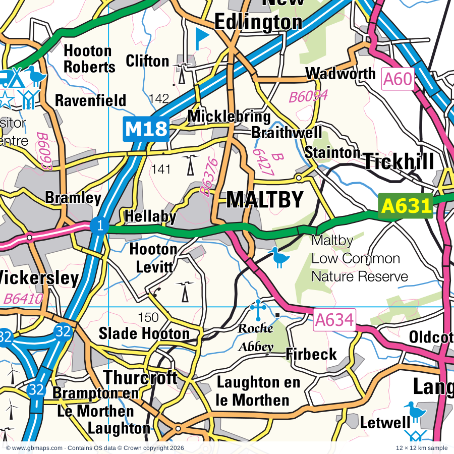
Maltby regional road map. Full 60 × 60 km PDF, SVG and Illustrator files, with a free PDF sample.

GBMAPS.COM

Maltby Regional Road Map

Call Us Now for Help01751 473136

GREAT BRITAIN ROAD ATLAS · 1:250,000 RY-31

Maltby & surrounding area

Explore the full 60 × 60 km Maltby regional road map at 1:250,000, covering Maltby, Rotherham, Conisbrough, Rawmarsh, Mexborough. Compare the complete coverage below; a detailed PDF sample is available free.

MALTBY & SURROUNDING AREAREGIONAL ROAD MAP
60 × 60 km · Full map previewDownload the free SVG ↓

INSIDE THE FULL 60 × 60 KM MAP

Explore the Maltby map area

1:250,000 cartography

Towns, villages & places

More mapped places (313)

Roads across this sheet

M1, M18, M180, A1(M), A6, A18, A19, A38, A57, A60, A61, A161, A614, A615, A616, A617, A618, A619, A620, A621, A623, A625, A628, A629

More road numbers

A630, A631, A632, A633, A634, A635, A636, A637, A638, A639, A642, A644, A645, A655, A1146, A6009, A6013, A6020, A6021, A6022, A6023, A6075, A6101, A6102, A6109, A6117, A6123, A6133, A6135, A6175, A6178, A6182, A6186, A6187, A6191, A6192, A6195, A6201, B1164, B1220, B1396, B1403, B5055, B5056, B5057, B6001, B6012, B6014, B6024, B6025, B6026, B6028, B6030, B6031, B6032, B6033, B6034, B6035, B6036, B6038, B6039, B6040, B6041, B6042, B6043, B6044, B6045, B6048, B6050, B6051, B6052, B6053, B6054, B6056, B6057, B6058, B6059, B6060, B6063, B6064, B6065, B6066, B6067, B6068, B6069, B6070, B6071, B6073, B6074, B6075, B6076, B6077, B6079, B6080, B6081, B6082, B6083, B6085, B6086, B6087, B6088, B6089, B6090, B6091, B6092, B6093, B6094, B6096, B6097, B6098, B6099, B6100, B6106, B6115, B6116, B6117, B6118, B6128, B6131, B6132, B6135, B6150, B6158, B6200, B6253, B6273, B6375, B6376, B6378, B6387, B6388, B6389, B6407, B6408, B6410, B6411, B6417, B6418, B6419, B6420, B6421, B6422, B6425, B6427, B6428, B6449, B6461, B6462, B6463, B6474, B6475, B6521, B6533, B6537, B6546, B6547

Rivers & waterways

Abbey Brook, Aire & Calder Navigation, Barnsley Canal (disused), Calder & Hebble Navigation, Canal (disused), Chesterfield Canal, Dutch River, Elsecar Canal (disused), New Junction Canal, River Amber, River Calder, River Dearne

More waterways

River Derwent, River Don, River Dun Navigation, River Idle, River Loxley, River Maun, River Meden, River Noe, River Poulter, River Rother, River Ryton, River Sheaf, River Torne, River Went, River Wye, Sheffield & Keadby Canal, Sheffield & South Yorkshire Navigation, Sheffield & Tinsley Canal, Stainforth & Keadby Canal, The Porter or Little Don River

Landmarks & landscape

Abbeydale Industrial Museum, Amen Corner (Karting), Anglers Country Park, Aston Pottery, Barrow Hill Roundhouse, Bassetlaw Museum & Percy Laws Memorial Gallery, Beauchief Abbey (remains of), Belton, Beth Shalom Holocaust Visitor Centre, Birdwell Lodge Craft Centre, Bishops House Museum, Bolsover Castle, PEAK DISTRICT NATIONAL PARK

More named features

Bretton Country Park, Brodsworth Hall and Gardens, Broomhill Flash Nature Reserve, Campsall Country Park, Cannon Hall Country Park, Cannon Hall Farm, Cannon Hall House & Museum, Caudwell's Mill, Cawthorne Museum, Charlotte's Jersey Ice Cream Parlour, Chatsworth House, Chesterfield Museum and Art Gallery, City Museum and Art Gallery, Kelham Island Industrial Museum, Sheffield Fire and Police Museum, Sheffield Traditional Heritage Museum, Clifton Park Museum, Clowne Linear Park, Clumber Park, Clumber Park & Visitor Centre, Conisbrough Castle, Conisbrough Castle and Visitor Centre, Creswell Crags Museum and Archaeology Park, Creswell Crags Visitor Centre, Cusworth Country Park, Daneshill Lakes Nature Reserve, Delta Force Paintball Leeds (Leewood), Denaby Ings Nature Reserve, Doncaster Museum & Art Gallery, Doncaster Aeroventure, Doncaster Racecourse, Dukes Wood Oil Museum, Dyscarr Wood Nature Reserve, Eaton and Gamston Wood Nature Reserve, Elsecar Industrial Heritage Centre, Elsecar Steam Railway, Epworth Old Rectory, Eyam Hall, Eyam Hall Craft Centre, Eyam Moor Stone Circle, Eyam Museum, Eyan Hall, Fitzwilliam Country Park, Grassmoor Country Park, Graves Art Gallery, Millennium Galleries, Site Gallery, Sheffield Winter Gardens, Graves Park Animal Farm, Haddon Hall, Hardwick Hall, Hardwick Hall Country Park, Hardwick Old Hall (remains of), Hardwick Park Visitor Centre, Haxey Nature Reserve, Haxey Reserve, Heeley City Farm, Highfields Country Park, Hob Hurst's House, Howell Wood Country Park, Idle Valley Nature Reserve, King's Wood, Kirklees Light Railway, Langold Country Park, Langwith Whaley Thorns Heritage Centre, Laxton Heritage Museum, Longshaw Estate, Longshaw Estate Visitor Centre, Magna, Making It, Maltby Low Common, Mansfield Museum, Matlock Farm Park, Mattersey Priory, Melton Wood Country Park, Monk Bretton Priory, Monument, Mr Straw's House, Museum Of Dolls & Bygone Childhood, Museum of South Yorkshire Life, National Coal Mining Museum for England, Newmillerdam Country Park, Nine Ladies (Stone Circle), North Leverton Windmill, Nostell Priory, Old Hall, Old Moor Wetlands Centre, Peak Railway, Phoenix Park, Poolsbrook Country Park, Potteric Carr Nature Reserve, Poulter Country Park, Pugneys Country Park, Rabbit Ings Country Park, Redhouse Stables Working Carriage Museum, Renishaw Hall, Renishaw Hall Gardens, Ridgeway Craft Centre, Roche Abbey, Rother Valley Country Park Nature Reserve, Rother Valley Country Park Visitor Centre, Rufford Abbey, Rufford Country Park, Rufford Mill, Sandal Castle, Sandal Castle (Remains of), Sandall Beat Wood Nature Reserve, Sandtoft Transport Centre, Sheffield Botanical Gardens, Sheffield Cathedral, St Marie's Cathedral, Sheffield Manor Lodge and Turret House, Sherwood Forest Art and Craft Centre, Sherwood Forest Country Park, Sherwood Forest Farm Park & Miniature Railway, Sherwood Heath Nature Reserve, Sherwood Pines Forest Park, Sherwood Pines Go Ape, South Yorkshire Transport Museum, Sprotbrough Flash, Stainsby Mill, Sundown Adventureland, Sutton Scarsdale Hall, Tapton Lock Visitor Centre, Teversal Visitor Centre, The Old House Museum, The Queen's Royal Lancers and Nott'shire Yeomanry Museum, The Revolution House Museum, The Round Building, The Walks Of Life Heritage Centre, Museum of the Horse, Thoresby Gallery, Thoresby Hall, Thorpe Marsh Nature Reserve, Thrybergh Country Park, Thrybergh Country Park Nature Reserve, Thrybergh Country Park Visitor Centre, Treswell Wood Nature Reserve, Tropical Butterfly House and Wildlife Centre, Turner Museum of Glass, Tuxford Windmill, Ulley Country Park and Visitor Centre, Visitor Centre, Welbeck Abbey, Wentworth Castle, Wentworth Castle Gardens, Westwood Country Park, Wetlands Animal Park, Wingfield Farm, Winster Market House, Worksop Priory, Worsbrough Country Park, Worsbrough Mill Museum, Wortley Top Forge Museum, Yorkshire Sculpture Park, Yorkshire Wildlife Centre

Local authority & parish coverage

Wholly or partly within the full map rectangle. These boundaries are coverage information, not additional artwork layers.

  • Ashfield DistrictPartly within
  • Barnsley DistrictPartly within
  • Bassetlaw DistrictPartly within
  • Bolsover DistrictPartly within
  • Chesterfield DistrictWholly within
  • Derbyshire Dales DistrictPartly within
  • Doncaster DistrictWholly within
  • East Riding of YorkshirePartly within
  • High Peak DistrictPartly within
  • Kirklees DistrictPartly within
  • Mansfield DistrictPartly within
  • Newark and Sherwood DistrictPartly within
  • North East Derbyshire DistrictPartly within
  • North LincolnshirePartly within
  • North YorkshirePartly within
  • Rotherham DistrictWholly within
  • Sheffield DistrictPartly within
  • Wakefield DistrictPartly within
  • West Lindsey DistrictPartly within
Wards & electoral divisions 258 areas
  • Ackworth, North Elmsall & Upton Ward (part)
  • Adwick le Street & Carcroft Ward
  • Almondbury Ward (part)
  • Anston & Woodsetts Ward
  • Armthorpe Ward
  • Ashover Ward (part)
  • Aston & Todwick Ward
  • Athersley & New Lodge Ward
  • Aughton & Swallownest Ward
  • Ault Hucknall Ward
  • Axholme Central Ward (part)
  • Axholme North Ward (part)
  • Axholme South Ward (part)
  • Bakewell Ward (part)
  • Balby South Ward
  • Bancroft Ward
  • Barlborough Ward
  • Barlow & Holmesfield Ward
  • Beauchief & Greenhill Ward
  • Beckingham Ward (part)
  • Beighton Ward
  • Bentley Ward
  • Bessacarr Ward
  • Bilsthorpe Ward (part)
  • Birley Ward
  • Blackwell Ward (part)
  • Blyth Ward
  • Bolsover East Ward
  • Bolsover North & Shuttlewood Ward
  • Bolsover South Ward
  • Bonsall & Winster Ward (part)
  • Boston Castle Ward
  • Boughton Ward
  • Bradwell Ward (part)
  • Bramley & Ravenfield Ward
  • Brampton & Walton Ward
  • Brampton East & Boythorpe Ward
  • Brampton West & Loundsley Green Ward
  • Brick Kiln Ward
  • Brimington North Ward
  • Brimington South Ward
  • Brinsworth Ward
  • Brockwell Ward
  • Broomhill & Sharrow Vale Ward
  • Burngreave Ward
  • Calver & Longstone Ward (part)
  • Carlton Ward
  • Carr Bank Ward
  • Carsic Ward (part)
  • Central Ward
  • Central Ward
  • Chatsworth Ward
  • City Ward
  • Clay Cross North Ward
  • Clay Cross South Ward
  • Clayworth Ward
  • Clowne East Ward
  • Clowne West Ward
  • Coal Aston Ward
  • Conisbrough Ward
  • Crofton, Ryhill & Walton Ward
  • Crookes & Crosspool Ward
  • Cudworth Ward
  • Dalton & Thrybergh Ward
  • Darfield & Great Houghton Ward
  • Darley Dale Ward
  • Darnall Ward
  • Darton East Ward
  • Darton West Ward
  • Dearne North Ward
  • Dearne South Ward
  • Denby Dale Ward (part)
  • Dewsbury South Ward (part)
  • Dewsbury West Ward (part)
  • Dinnington Ward
  • Dodworth, Stainborough & Tankersley Ward
  • Dore & Totley Ward
  • Dronfield North Ward
  • Dronfield South Ward
  • Dronfield Woodhouse Ward
  • Dunston Ward
  • Eakring Ward
  • East Ecclesfield Ward
  • East Markham Ward
  • East Retford East Ward
  • East Retford North Ward
  • East Retford South Ward
  • East Retford West Ward
  • Ecclesall Ward
  • Eckington North Ward
  • Eckington South & Renishaw Ward
  • Edenthorpe & Kirk Sandall Ward
  • Edlington & Warmsworth Ward
  • Edwinstowe & Clipstone Ward
  • Elmton-with-Creswell Ward
  • Everton Ward
  • Featherstone Ward (part)
  • Finningley Ward
  • Firth Park Ward
  • Fulwood Ward
  • Gleadless Valley Ward
  • Gosforth Valley Ward
  • Grange Farm Ward (part)
  • Grassmoor Ward
  • Graves Park Ward
  • Greasbrough Ward
  • Harworth Ward
  • Hasland Ward
  • Hatfield Ward
  • Hathersage Ward (part)
  • Hellaby & Maltby West Ward
  • Hemsworth Ward
  • Hexthorpe & Balby North Ward
  • Hillsborough Ward
  • Holly Forest Town Ward
  • Holmewood & Heath Ward
  • Hoober Ward
  • Hope Valley Ward (part)
  • Horbury & South Ossett Ward (part)
  • Hornby Ward
  • Hoyland Milton Ward
  • Huthwaite & Brierley Ward (part)
  • Keppel Ward
  • Killamarsh East Ward
  • Killamarsh West Ward
  • Kilnhurst & Swinton East Ward
  • Kings Walk Ward (part)
  • Kingstone Ward
  • Kingsway Forest Town Ward
  • Kirkburton Ward (part)
  • Langold Ward
  • Langwith Ward
  • Linacre Ward
  • Ling Forest Ward (part)
  • Maltby East Ward
  • Manor Castle Ward
  • Manor Ward
  • Market Warsop Ward
  • Matlock East & Tansley Ward (part)
  • Matlock West Ward (part)
  • Maun Valley Forest Town Ward
  • Meden Ward
  • Mexborough Ward
  • Mill Lane Ward
  • Mirfield Ward (part)
  • Misterton Ward
  • Monk Bretton Ward
  • Mosborough Ward
  • Muskham Ward (part)
  • Nether Edge & Sharrow Ward
  • Netherfield Ward
  • Newlands Forest Town Ward
  • Normanton Ward (part)
  • North East Ward
  • North Wingfield Central Ward
  • Norton & Askern Ward
  • Oak Tree Ward (part)
  • Oakham Ward (part)
  • Old Town Ward
  • Ollerton Ward
  • Ossett Ward (part)
  • Park & Arbourthorne Ward
  • Park Hall Ward
  • Penistone East Ward
  • Penistone West Ward (part)
  • Penniment Ward
  • Pilsley & Morton Ward (part)
  • Pleasley Ward
  • Pontefract South Ward (part)
  • Racecourse Ward
  • Rainworth North & Rufford Ward (part)
  • Rampton Ward (part)
  • Ranskill Ward
  • Rawmarsh East Ward
  • Rawmarsh West Ward
  • Richmond Ward
  • Ridgeway & Marsh Lane Ward
  • Rock Hill Ward
  • Rockingham Ward
  • Roman Ridge Ward
  • Rossington & Bawtry Ward
  • Rother Vale Ward
  • Rother Ward
  • Rotherham East Ward
  • Rotherham West Ward
  • Royston Ward
  • Rufford Ward
  • Scotter and Blyton Ward (part)
  • Sherwood Ward
  • Shirebrook North Ward
  • Shirebrook South Ward
  • Shiregreen & Brightside Ward
  • Shirland Ward (part)
  • Sitwell Ward
  • Skegby Ward (part)
  • Snaith, Airmyn, Rawcliffe and Marshland Ward (part)
  • South Elmsall & South Kirkby Ward
  • Southey Ward
  • Southwell Ward (part)
  • Southwell Ward (part)
  • Spire Ward
  • Sprotbrough Ward
  • Stainforth & Barnby Dun Ward
  • Stairfoot Ward
  • Stannington Ward (part)
  • Stanton Hill & Teversal Ward
  • Staveley Central Ward
  • Staveley North Ward
  • Staveley South Ward
  • Stocksbridge & Upper Don Ward (part)
  • Sturton Ward (part)
  • Sutton Central & New Cross Ward (part)
  • Sutton Ward
  • Sutton Ward
  • Sutton-on-Trent Ward (part)
  • Swinton Rockingham Ward
  • The Dales Ward (part)
  • Thompsons Ward (part)
  • Thorne & Moorends Ward
  • Thurcroft & Wickersley South Ward
  • Tibshelf Ward (part)
  • Tickhill & Wadsworth Ward
  • Town Ward
  • Tupton Ward
  • Tuxford and Trent Ward (part)
  • Unstone Ward
  • Vale Ward
  • Wainwright Ward
  • Wakefield East Ward (part)
  • Wakefield Rural Ward
  • Wakefield South Ward
  • Wakefield West Ward (part)
  • Wales Ward
  • Walkley Ward
  • Walton Ward
  • Warsop Carrs Ward
  • Wath Ward
  • Welbeck Ward
  • West Bank Ward
  • West Ecclesfield Ward
  • Wheatley Hills & Intake Ward
  • Whittington Moor Ward
  • Whittington Ward
  • Whitwell Ward
  • Wickersley North Ward
  • Wingerworth Ward
  • Wombwell Ward
  • Woodhouse Ward
  • Worksop East Ward
  • Worksop North East Ward
  • Worksop North Ward
  • Worksop North West Ward
  • Worksop South East Ward
  • Worksop South Ward
  • Worsbrough Ward
  • Yeoman Hill Ward
  • Youlgrave Ward (part)
  • Osgoldcross ED (part)
Civil parishes & communities 325 areas
  • Abney and Abney Grange CP (part)
  • Ackworth CP
  • Adwick upon Dearne CP
  • Armthorpe CP
  • Ashford in the Water CP (part)
  • Ashover CP (part)
  • Askern CP
  • Askham CP
  • Aston cum Aughton CP
  • Auckley CP
  • Ault Hucknall CP
  • Austerfield CP
  • Babworth CP
  • Badsworth CP
  • Bakewell CP (part)
  • Balne CP (part)
  • Bamford CP (part)
  • Barlborough CP
  • Barlow CP
  • Barnburgh CP
  • Barnby Dun with Kirk Sandall CP
  • Barnby Moor CP
  • Baslow and Bubnell CP
  • Bathley CP (part)
  • Bawtry CP
  • Beckingham CP (part)
  • Beeley CP
  • Belton CP (part)
  • Bevercotes CP
  • Billingley CP
  • Bilsthorpe CP (part)
  • Birchover CP
  • Blackwell CP (part)
  • Blaxton CP
  • Blyth CP
  • Blyton CP (part)
  • Bole CP (part)
  • Bothamsall CP
  • Brackenfield CP (part)
  • Bradfield CP (part)
  • Braithwell CP
  • Bramley CP
  • Brampton Bierlow CP
  • Brampton CP
  • Brimington CP
  • Brinsworth CP
  • Brodsworth CP
  • Brough and Shatton CP (part)
  • Burghwallis CP
  • Cadeby CP
  • Calow CP
  • Calver CP
  • Cantley CP
  • Carburton CP
  • Carlton in Lindrick CP
  • Carlton-on-Trent CP (part)
  • Catcliffe CP
  • Caunton CP (part)
  • Cawthorne CP
  • Chatsworth CP
  • Chevet CP
  • Clarborough and Welham CP
  • Clay Cross CP
  • Clayton with Frickley CP
  • Clayworth CP
  • Clipstone CP
  • Clowne CP
  • Clumber and Hardwick CP
  • Conisbrough Parks CP
  • Crigglestone CP
  • Crofton CP
  • Cromwell CP (part)
  • Crowle and Ealand CP (part)
  • Curbar CP
  • Dalton CP
  • Darley Dale CP
  • Darlton CP
  • Darrington CP (part)
  • Denaby CP
  • Denby Dale CP (part)
  • Derwent CP (part)
  • Dinnington St. John's CP
  • Dronfield CP
  • Dunford CP (part)
  • Dunham-on-Trent CP (part)
  • Eakring CP
  • East Drayton CP
  • East Hardwick CP
  • East Markham CP
  • East Stockwith CP (part)
  • Eastoft CP (part)
  • Eaton CP
  • Ecclesfield CP
  • Eckington CP
  • Edensor CP
  • Edenthorpe CP
  • Edlington CP
  • Edwinstowe CP
  • Egmanton CP
  • Elkesley CP
  • Elmton with Creswell CP
  • Elton CP (part)
  • Epworth CP (part)
  • Everton CP
  • Eyam CP (part)
  • Featherstone CP (part)
  • Fenwick CP
  • Finningley CP
  • Firbeck CP
  • Fishlake CP
  • Fledborough CP (part)
  • Foolow CP (part)
  • Froggatt CP
  • Gamston CP
  • Gildingwells CP
  • Glapwell CP
  • Goole Fields CP (part)
  • Grassmoor, Hasland and Winsick CP
  • Grassthorpe CP (part)
  • Gratton CP (part)
  • Great Houghton CP
  • Great Longstone CP (part)
  • Grindleford CP
  • Gringley on the Hill CP
  • Grove CP
  • Gunthwaite and Ingbirchworth CP
  • Hampole CP
  • Harthill CP
  • Harthill with Woodall CP
  • Harworth Bircotes CP
  • Hassop CP
  • Hatfield CP
  • Hathersage CP
  • Haughton CP
  • Havercroft with Cold Hiendley CP
  • Haxey CP (part)
  • Hayton CP
  • Headon cum Upton CP
  • Heath and Holmewood CP
  • Heck CP (part)
  • Hellaby CP
  • Hemsworth CP
  • Hessle and Hill Top CP
  • Hickleton CP
  • High Hoyland CP
  • High Melton CP
  • Highlow CP
  • Hockerton CP (part)
  • Hodsock CP
  • Hodthorpe and Belph CP
  • Holmesfield CP
  • Holymoorside and Walton CP
  • Hooton Levitt CP
  • Hooton Pagnell CP
  • Hooton Roberts CP
  • Hunshelf CP
  • Huntwick with Foulby and Nostell CP (part)
  • Kersall CP
  • Killamarsh CP
  • Kings Clipstone CP
  • Kirk Bramwith CP
  • Kirk Smeaton CP
  • Kirkburton CP (part)
  • Kirklington CP (part)
  • Kirton CP
  • Kneesall CP
  • Laneham CP (part)
  • Langsett CP (part)
  • Langwith CP
  • Laughton-en-le-Morthen CP
  • Laxton and Moorhouse CP
  • Letwell CP
  • Little Houghton CP
  • Little Smeaton CP
  • Lound CP
  • Loversall CP
  • Maltby CP
  • Maplebeck CP (part)
  • Marnham CP (part)
  • Marr CP
  • Matlock Town CP (part)
  • Mattersey CP
  • Middleton and Smerrill CP (part)
  • Mirfield CP (part)
  • Misson CP
  • Misterton CP
  • Morton CP (part)
  • Morton CP (part)
  • Moss CP
  • Nether Haddon CP
  • Nether Langwith CP
  • Normanton on Trent CP (part)
  • North Leverton with Habblesthorpe CP (part)
  • North Muskham CP (part)
  • North Wingfield CP
  • North and South Anston CP
  • North and South Wheatley CP
  • Northwood and Tinkersley CP
  • Norton CP
  • Norton, Cuckney, Holbeck and Welbeck CP
  • Norwell CP
  • Notton CP
  • Offerton CP
  • Old Bolsover CP
  • Ollerton and Boughton CP
  • Ompton CP
  • Orgreave CP
  • Ossington CP
  • Over Haddon CP (part)
  • Owston CP
  • Owston Ferry CP (part)
  • Oxspring CP
  • Penistone CP
  • Perlethorpe cum Budby CP
  • Pilsley CP
  • Pilsley CP
  • Pleasley CP
  • Pollington CP (part)
  • Ragnall CP (part)
  • Rainworth CP (part)
  • Rampton and Woodbeck CP (part)
  • Ranskill CP
  • Ravenfield CP
  • Rawcliffe CP (part)
  • Reedness CP (part)
  • Rhodesia CP
  • Rossington CP
  • Rowland CP
  • Rowsley CP
  • Rufford CP (part)
  • Ryhill CP
  • Saundby CP (part)
  • Scaftworth CP
  • Scarcliffe CP
  • Scrooby CP
  • Shafton CP
  • Sharlston CP (part)
  • Shirebrook CP
  • Shireoaks CP
  • Shirland and Higham CP (part)
  • Silkstone CP
  • Sitlington CP
  • Snaith and Cowick CP (part)
  • South Darley CP (part)
  • South Elmsall CP
  • South Hiendley CP
  • South Kirkby and Moorthorpe CP
  • South Leverton CP (part)
  • Sprotbrough and Cusworth CP
  • Stainborough CP
  • Stainforth CP
  • Stainton CP
  • Stanton CP
  • Stapleton CP (part)
  • Staveley CP
  • Stocksbridge CP
  • Stokeham CP
  • Stoney Middleton CP (part)
  • Stretton CP (part)
  • Stubbs Walden CP
  • Sturton Le Steeple CP (part)
  • Styrrup with Oldcotes CP
  • Sutton CP
  • Sutton cum Duckmanton CP
  • Sutton-on-Trent CP (part)
  • Swinefleet CP (part)
  • Sykehouse CP
  • Tankersley CP
  • Tansley CP (part)
  • Temple Normanton CP
  • Thorne CP
  • Thornhill CP (part)
  • Thorpe Audlin CP
  • Thorpe Salvin CP
  • Thorpe in Balne CP
  • Thrybergh CP
  • Thurcroft CP
  • Thurgoland CP
  • Tibshelf CP (part)
  • Tickhill CP
  • Todwick CP
  • Torworth CP
  • Treeton CP
  • Treswell CP (part)
  • Tupton CP
  • Tuxford CP
  • Twin Rivers CP (part)
  • Ulley CP
  • Unstone CP
  • Upton and North Elmsall CP
  • Wadworth CP
  • Wales CP
  • Walesby CP
  • Walkeringham CP (part)
  • Walkerith CP
  • Wallingwells CP
  • Walton CP
  • Warmfield cum Heath CP (part)
  • Warmsworth CP
  • Warsop CP
  • Waverley CP
  • Wellow CP
  • Wentbridge CP
  • Wentworth CP
  • West Bretton CP
  • West Burton CP (part)
  • West Drayton CP
  • West Hardwick CP
  • West Markham CP
  • West Stockwith CP
  • Weston CP
  • Whiston CP
  • Whitley CP (part)
  • Whitwell CP
  • Wickersley CP
  • Wingerworth CP
  • Winkburn CP (part)
  • Winster CP (part)
  • Wiseton CP
  • Womersley CP (part)
  • Woodsetts CP
  • Woolley CP
  • Wortley CP
  • Wroot CP
  • Youlgreave CP (part)

Source: the GBMaps road atlas, OS Boundary-Line and postcode mapping datasets. Source editions are being checked for publication. Unmarked boundary names are wholly within the sheet; “part” means the map edge crosses the area.

Place lists are selected from the map source, not a complete gazetteer. Named features describe the cartography; visitor facilities and opening status are not verified. The free sample covers only 12 × 12 km of this larger sheet.

INSIDE YOUR DOWNLOAD

A proper road map, in useful formats

Road classifications, towns and villages, railways, rivers, landscape detail and tourist symbols, brought together in the GBMaps regional road atlas style.

PDF filePDFSVG fileSVGAdobe Illustrator AI fileAi

PDF for the finished map. SVG and layered Illustrator artwork for adapting colours, adding your own information and preparing designs.

THE FINISHED SHEET

Designed for print and presentation

Map coverage
60 × 60 km
Sample coverage
12 × 12 km
Print layout
A3 landscape · enlarged 1:250k cartography
Sheet furniture
Border, scale bar, key & north arrow

A few useful details

What changes when I select another square?

Select a surrounding square to bring it into the centre and reveal the maps around it. Each square is a different 60 × 60 km map. The preview, free sample and selected download change together. Neighbouring sheets overlap by 30 km so you can choose the coverage that suits you.

Is the free sample a vector map?

The on-page detail is an SVG. The free download is a separate 12 × 12 km PDF with a link to the full map. Please retain its copyright credits and product link when sharing it.

Can I buy a larger combined map?

These downloads are individual ready-made sheets. Contact GBMaps if you need a larger combined area.

FREE PDF SAMPLE

Your free map sample

Your free 12 × 12 km sample includes a link back to this map, so you can return for the full area whenever you need it.

Download free PDF sample ↓

Get your Maltby map

Map download bundle

£24.00including VATOne payment

Pay securely

One payment. Your map stays open.

Your map download

Your map files

Preparing your download…

Checking your private download link…

Your map downloads

Already bought a map?

Find the downloads from your purchases.

Enter the email address you used at checkout. We’ll email you a private link to your available map downloads.