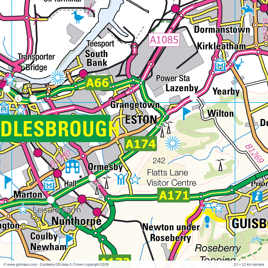
Eston regional road map. Full 60 × 60 km PDF, SVG and Illustrator files, with a free PDF sample.

GBMAPS.COM

Eston Regional Road Map

Call Us Now for Help01751 473136

GREAT BRITAIN ROAD ATLAS · 1:250,000 RY-35

Eston & surrounding area

Explore the full 60 × 60 km Eston regional road map at 1:250,000, covering Middlesbrough, Eston, Guisborough, On-Tees, Stockton-. Compare the complete coverage below; a detailed PDF sample is available free.

ESTON & SURROUNDING AREAREGIONAL ROAD MAP
60 × 60 km · Full map previewDownload the free SVG ↓

INSIDE THE FULL 60 × 60 KM MAP

Explore the Eston map area

1:250,000 cartography

Towns, villages & places

More mapped places (209)
  • Masham
  • Seamer
  • Newby
  • Tanton
  • Stokesley
  • Hilton
  • Thornton
  • Stainton
  • Maltby
  • Great Busby
  • Kirkby
  • Crathorne
  • Potto
  • Kirklevington
  • Faceby
  • Whorlton
  • Easby
  • Swainby
  • Picton
  • Egglescliffe
  • Aislaby
  • Battersby
  • Eston
  • Urra
  • Kildale
  • Grangetown
  • Chop Gate
  • Lazenby
  • Elton
  • Welbury
  • Wilton
  • Long Newton
  • Osmotherley
  • Dunsdale
  • Hornby
  • Girsby
  • Deighton
  • Yearby
  • Ellerbeck
  • Kirkleatham
  • Thimbleby
  • Sockburn
  • Low Dinsdale
  • Charltons
  • Carlton
  • Redmarshall
  • Wolviston
  • Commondale
  • Upleatham
  • Cockayne
  • New Marske
  • Westerdale
  • Sadberge
  • Neasham
  • Whitton
  • Boosbeck
  • Lovesome Hill
  • Over Silton
  • Greatham
  • Bishopton
  • Eryholme
  • Nether Silton
  • Hutton Bonville
  • Stanghow
  • Stillington
  • Birkby
  • Brompton
  • Lingdale
  • Wynyard
  • Castleton
  • Kepwick
  • Moorsholm
  • Barmpton
  • Foxton
  • Cowesby
  • Ainthorpe
  • Danby
  • Church Houses
  • Elstob
  • Romanby
  • Liverton
  • Borrowby
  • Streetlam
  • Elwick
  • Knayton
  • Brafferton
  • Boltby
  • Upsall
  • Skinningrove
  • Mordon
  • Stapleton
  • Houlsyke
  • Warlaby
  • Street
  • Old Byland
  • Whitwell
  • Thrintoft
  • Thorgill
  • Hart
  • Cleasby
  • Felixkirk
  • Sheraton
  • Easington
  • Bradbury
  • Carlton
  • Thirlby
  • Rievaulx
  • Fishburn
  • Newton Morrell
  • Lealholm
  • Uckerby
  • Kirkby Fleetham
  • Scruton
  • Scorton
  • Roxby
  • Scawton
  • Moulton
  • Barton
  • Gillamoor
  • Fadmoor
  • Little Fencote
  • Trimdon
  • Boulby
  • Borrowby
  • Pockley
  • Maunby
  • Middleton Tyas
  • Glaisdale
  • Heighington
  • Manfield
  • Gatenby
  • Walworth
  • Catterick
  • Rushyford
  • Hesleden
  • Blackhall Rocks
  • Redworth
  • Chilton
  • Leeming Bar
  • Leeming
  • Deaf Hill
  • Sowerby
  • Ugthorpe
  • Staithes
  • Piercebridge
  • Beadlam
  • Denton
  • Middridge
  • Nawton
  • Bagby
  • Londonderry
  • Spaunton
  • Lastingham
  • Hinderwell
  • Ellerby
  • Sandhutton
  • Port Mulgrave
  • Hackforth
  • Pickhill
  • Sproxton
  • Kelloe
  • Skeeby
  • Cornforth
  • Exelby
  • Langthorne
  • Wombleton
  • Theakston
  • Coxhoe
  • Burneston
  • Harome
  • Aiskew
  • Wheatley Hill
  • Keldholme
  • Tunstall
  • Sinderby
  • Hornby
  • Cassop
  • Middlestone
  • Thornley
  • Coundon
  • Carthorpe
  • Bildershaw
  • Howe
  • Cropton
  • Great Edstone
  • Kirklington
  • Bowburn
  • Arrathorne
  • Sinnington
  • Hett
  • Stape
  • Burrill
  • Cowling
  • Snape
  • Muscoates
  • Marton
  • Croxdale
  • Wrelton
  • Well
  • Aislaby
  • Byers Green
  • Salton
  • Nosterfield
  • Normanby
  • Thirn
  • Middleton
  • Newfield
  • Brancepeth
  • Oakenshaw

Roads across this sheet

A1(M), A19, A61, A66, A66(M), A67, A68, A135, A139, A167, A168, A169, A170, A171, A172, A173, A174, A177, A178, A179, A181, A617, A684, A688

More road numbers

A689, A690, A1027, A1032, A1042, A1043, A1044, A1046, A1049, A1053, A1085, A1086, A1130, A1150, A1185, A1305, A6055, A6072, A6108, A6136, B1257, B1263, B1264, B1265, B1266, B1268, B1269, B1272, B1274, B1275, B1276, B1277, B1278, B1279, B1280, B1281, B1292, B1333, B1365, B1366, B1376, B1380, B1448, B1513, B6267, B6268, B6271, B6272, B6275, B6279, B6280, B6282, B6284, B6285, B6287, B6288, B6291, B6300, B6443, B6444, B6541

Rivers & waterways

Cod Beck, Costa Beck, Hodge Beck, River Browney, River Dove, River Esk, River Gaunless, River Leven, River Riccal, River Rye, River Seph, River Seven

More waterways

River Skerne, River Swale, River Tees, River Ure, River Wear, River Wiske

Landmarks & landscape

Adventure Activity Centre, Auckland Castle, Auckland Castle Deer House, Beck Isle Museum of Rural Life, Bedale Hall Museum, Billingham Beck Valley Country Park, Billingham Beck Valley Nature Reserve, Billingham Beck Valley Visitor Centre, Bishop Auckland Discovery Centre, Black Sheep Brewery Visitor Centre, Theakston Brewery Visitor Centre, Masham Art Gallery, Blackhall Roaks Nature Reserve, Butterfly World, NORTH YORK MOORS NATIONAL PARK

More named features

Captain Cook's Birthplace Museum, Captain Cook's Monument, Captain Cook's Museum, Captain Cooks and Staithes Heritage Centre, Castle Eden Dene Nature Reserve, Catterick Racecourse, Cawthorne Roman Camps, Charlton's Pond Nature Reserve, Cow Close Nature Reserve, Cowpen Bewley Woodland Country Park, Cowpen Nature Reserve, Craft Centre, Croft Motor Racing Circuit, Cropton Brewery and Visitor Centre, Darlington Railway Centre and Museum, Dorman Museum, Duncombe Park, Endeavour, Dovecot Arts Centre, Errington Wood, Falconry UK Birds of Prey Centre, Flamingo Land, Flatts Lane Visitor Centre, Flatts Lane Woodland Country Park, Gisborough Priory, Guisborough Forest Visitor Centre, Guisborough Museum, Hardwick Hall Country Park & Visitor Centre, Hartlepool Power Station Visitor Centre, Hartlepool's Maritime Experience, Gray Art Gallery, Art Gallery, Hazel Grove Nature Reserve, Headland Rocks and Fossil Forest Nature Reserve, Helmsley Castle, Helmsley Walled Garden, Hob Hole, Hurworth Burn and Crookfoot Reservoir Nature Reserve, International Centre for Birds of Prey, Keldy Castle, Kilburn White Horse, Kilburn White Horse (Hill Figure), Kiplin Hall, Kiplin Hall and Gardens, Kirkleatham Old Hall Museum, Kirkleatham Owl Centre, Locomotion: The National Railway Museum at Shildon, Lord Stones Country Park, MIMA (Middlesbrough Institute of Modern Art), Marfield Nature Reserve, Millennium Stone, Monk Park Farm Visitor Centre, Monument, Mount Grace Priory, Museum of Hartlepool, Heugh Battery, Newham Grange Leisure Farm, North Yorkshire Moors Railway, Nunnington Hall, Ormesby Hall, Osgodby Hall, Pickering Castle, Piercebridge Roman Bridge, Preston Park Museum, ROMAN CAMP, Ralph Crosses, Redcar Racecourse, Rievaulx Abbey, Rievaulx Terrace and Temples, Rosa Shafto Nature Reserve, Ryedale Folk Museum, Saltburn Gill Nature Reserve, Saltburn Valley Woodland Centre, Saltburn's Inclined Tramway, Sedgefield Racecourse, Sion Hill Hall, Snape Castle, Spout House (The Original Sun Inn), Summerhill Country Park, Summerhill Visitor Centre, Sutton Bank National Park Centre, Tees Barrage, Tees Cottage Water Pumping and Steam Museum, The Big Sheep & Little Cow Farm, The Moors National Park Centre, The RNLI Zetland Lifeboat Museum, Thirsk Museum, The World of James Herriot, Thirsk Racecourse, Thorpe Perrow Aboretum, Thorpe Wood Nature Reserve, Thrislington Nature Reserve, Timothy Hackworth Museum, Tom Leonard Mining Museum, Transporter Bridge and Visitor Centre, Tweddle Childrens Animal Farm, Wain Stones, Wheatley Hill Heritage Centre, Whitworth Hall Country Park, Wingate Quarry, Wynyard Woodland Country Park, Wynyard Woodland Visitor Centre, Wynyard Planetarium and Observatory
Local authority & parish coverage

Wholly or partly within the full map rectangle. These boundaries are coverage information, not additional artwork layers.

  • County DurhamPartly within
  • DarlingtonPartly within
  • HartlepoolWholly within
  • MiddlesbroughWholly within
  • North YorkshirePartly within
  • Redcar and ClevelandWholly within
  • Stockton-on-TeesWholly within
Wards & electoral divisions 153 areas
  • Acklam Ward
  • Ayresome Ward
  • Bank Top & Lascelles Ward
  • Belmont Ward
  • Berwick Hills & Pallister Ward
  • Billingham Central Ward
  • Billingham East Ward
  • Billingham North Ward
  • Billingham South Ward
  • Billingham West & Wolviston Ward
  • Bishopsgarth & Elm Tree Ward
  • Brambles & Thorntree Ward
  • Brinkburn & Faverdale Ward
  • Brotton Ward
  • Burn Valley Ward
  • Central Ward
  • Coatham Ward
  • Cockerton Ward
  • College Ward
  • Coulby Newham Ward
  • De Bruce Ward
  • Dormanstown Ward
  • Eaglescliffe East Ward
  • Eaglescliffe West Ward
  • Eastbourne Ward
  • Eston Ward
  • Fairfield Ward
  • Fens & Greatham Ward
  • Foggy Furze Ward
  • Grangefield Ward
  • Grangetown Ward
  • Guisborough Ward
  • Hardwick & Salters Lane Ward
  • Harrowgate Hill Ward
  • Hart Ward
  • Hartburn Ward
  • Haughton & Springfield Ward
  • Headland & Harbour Ward
  • Heighington & Coniscliffe Ward (part)
  • Hemlington Ward
  • Hummersknott Ward
  • Hurworth Ward
  • Hutton Ward
  • Ingleby Barwick North Ward
  • Ingleby Barwick South Ward
  • Kader Ward
  • Kirkleatham Ward
  • Ladgate Ward
  • Linthorpe Ward
  • Lockwood Ward
  • Loftus Ward
  • Longbeck Ward
  • Longlands & Beechwood Ward
  • Mandale & Victoria Ward
  • Manor House Ward
  • Marton East Ward
  • Marton West Ward
  • Mowden Ward
  • Newcomen Ward
  • Newport Ward
  • Newtown Ward
  • Normanby Ward
  • North Ormesby Ward
  • North Road Ward
  • Northern Parishes Ward
  • Northgate Ward
  • Norton Central Ward
  • Norton North Ward
  • Norton South Ward
  • Nunthorpe Ward
  • Ormesby Ward
  • Park East Ward
  • Park End & Beckfield Ward
  • Park Ward
  • Park West Ward
  • Pierremont Ward
  • Red Hall & Lingfield Ward
  • Ropner Ward
  • Roseworth Ward
  • Rossmere Ward
  • Rural West Ward
  • Sadberge & Middleton St. George Ward
  • Saltburn Ward
  • Seaton Ward
  • Skelton East Ward
  • Skelton West Ward
  • South Bank Ward
  • Southern Villages Ward
  • St. Germain's Ward
  • Stainsby Hill Ward
  • Stainton & Thornton Ward
  • Stephenson Ward
  • Stockton Town Centre Ward
  • Teesville Ward
  • Throston Ward
  • Trimdon Ward
  • Victoria Ward
  • Village Ward
  • West Dyke Ward
  • Wheatlands Ward
  • Whinfield Ward
  • Yarm Ward
  • Zetland Ward
  • Aiskew & Leeming ED
  • Amotherby & Ampleforth ED (part)
  • Aycliffe North & Middridge ED
  • Aycliffe South ED
  • Bedale ED (part)
  • Bishop Auckland ED (part)
  • Blackhalls & Hesledens ED (part)
  • Bowburn & Coxhoe ED (part)
  • Brandon ED (part)
  • Castle Eden & Passfield ED (part)
  • Catterick Village & Brompton-on-Swale ED (part)
  • Chilton ED
  • Danby & Mulgrave ED (part)
  • Deerness ED (part)
  • Easington & Shotton ED (part)
  • Elvet, Gilesgate & Shincliffe ED (part)
  • Esk Valley & Coast ED (part)
  • Evenwood ED (part)
  • Ferryhill ED
  • Great Ayton ED
  • Helmsley & Sinnington ED (part)
  • Hillside & Raskelf ED (part)
  • Hipswell & Colburn ED (part)
  • Horden & Dene House ED (part)
  • Hutton Rudby & Osmotherley ED
  • Kirkbymoorside & Dales ED (part)
  • Leyburn & Middleham ED (part)
  • Lower Teesdale ED (part)
  • Masham & Fountains ED (part)
  • Morton-on-Swale & Appleton Wiske ED
  • Neville's Cross ED (part)
  • North Richmondshire ED (part)
  • Northallerton North & Brompton ED
  • Northallerton South ED
  • Peterlee ED (part)
  • Pickering ED (part)
  • Romanby ED
  • Scotton & Lower Wensleydale ED (part)
  • Sedgefield ED
  • Shildon & Dene Valley ED
  • Sowerby & Topcliffe ED (part)
  • Spennymoor ED (part)
  • Stokesley ED
  • Thirsk ED (part)
  • Thornley & Wheatley Hill ED (part)
  • Trimdon & Wingate ED
  • Tudhoe ED
  • Wathvale & Bishop Monkton ED (part)
  • West Auckland ED (part)
  • Willington & Hunwick ED (part)
Civil parishes & communities 335 areas
  • Ainderby Miers with Holtby CP
  • Ainderby Quernhow CP (part)
  • Ainderby Steeple CP
  • Aiskew and Leeming Bar CP
  • Aislaby CP
  • Aislaby CP
  • Akebar CP (part)
  • Aldbrough CP (part)
  • Ampleforth CP (part)
  • Appleton East and West CP
  • Appleton Wiske CP
  • Appleton-le-Moors CP
  • Archdeacon Newton CP
  • Arrathorne CP (part)
  • Bagby CP (part)
  • Baldersby CP (part)
  • Balk CP (part)
  • Barmpton CP
  • Barton CP
  • Barugh (Great and Little) CP (part)
  • Beadlam CP
  • Bedale CP
  • Billingham CP
  • Bilsdale Midcable CP
  • Birkby CP
  • Bishop Auckland CP (part)
  • Bishop Middleham CP
  • Bishopton CP
  • Bolam CP (part)
  • Boltby CP
  • Bolton-on-Swale CP
  • Borrowby CP
  • Borrowby CP
  • Bradbury and the Isle CP
  • Brafferton CP
  • Brancepeth CP (part)
  • Brandon and Byshottles CP (part)
  • Bransdale CP
  • Brawby CP (part)
  • Brierton CP
  • Brompton CP
  • Brompton-on-Swale CP
  • Brough with St. Giles CP
  • Burneston CP
  • Burrill with Cowling CP
  • Burton-on-Yore CP (part)
  • Byland with Wass CP (part)
  • Carlton CP
  • Carlton CP
  • Carlton Miniott CP (part)
  • Carthorpe CP
  • Cassop-cum-Quarrington CP (part)
  • Castle Eden CP (part)
  • Castlelevington CP
  • Catterick CP
  • Chilton CP
  • City of Durham CP (part)
  • Claxton CP
  • Cleasby CP
  • Cliffe CP (part)
  • Clifton-on-Yore CP
  • Coatham Mundeville CP
  • Colburn CP (part)
  • Cold Kirby CP
  • Commondale CP
  • Cornforth CP
  • Cotcliffe CP
  • Cowesby CP
  • Coxhoe CP
  • Crakehall CP
  • Crathorne CP
  • Croft-on-Tees CP
  • Cropton CP
  • Crosby CP
  • Croxdale and Hett CP
  • Dalton Piercy CP
  • Dalton-on-Tees CP
  • Danby CP
  • Danby Wiske with Lazenby CP
  • Deighton CP
  • Dene Valley CP
  • Denton CP
  • Easby CP
  • Easby CP (part)
  • East Cowton CP
  • East Harlsey CP
  • East Rounton CP
  • East Tanfield CP (part)
  • East Witton CP (part)
  • East and West Newbiggin CP
  • Edstone CP
  • Egglescliffe CP
  • Egton CP (part)
  • Eldon CP
  • Ellerbeck CP
  • Ellerby CP (part)
  • Ellerton-on-Swale CP
  • Ellington High and Low CP (part)
  • Elton CP
  • Elwick CP
  • Eryholme CP
  • Etherley CP (part)
  • Exelby, Leeming and Londonderry CP
  • Faceby CP
  • Fadmoor CP
  • Farndale East CP
  • Farndale West CP
  • Fearby CP (part)
  • Felixkirk CP
  • Ferryhill CP
  • Firby CP
  • Fishburn CP
  • Gainford CP (part)
  • Gatenby CP
  • Gillamoor CP
  • Gilling with Hartforth and Sedbury CP (part)
  • Girsby CP
  • Glaisdale CP
  • Great Aycliffe CP
  • Great Ayton CP
  • Great Burdon CP
  • Great Busby CP
  • Great Langton CP
  • Great Smeaton CP
  • Great Stainton CP
  • Great and Little Broughton CP
  • Greater Willington CP (part)
  • Greatham CP
  • Grindon and Thorpe Thewles CP
  • Guisborough CP
  • Hackforth CP
  • Harome CP
  • Hart CP
  • Hartoft CP
  • Hawnby CP
  • Headland CP
  • Heighington CP
  • Helmsley CP
  • High Coniscliffe CP
  • High Worsall CP
  • Hilton CP
  • Hinderwell CP (part)
  • Holme CP
  • Hood Grange CP
  • Hornby CP
  • Hornby CP
  • Houghton Le Side CP
  • Howe CP (part)
  • Howgrave CP (part)
  • Hunton CP (part)
  • Hurworth CP
  • Hutton Bonville CP
  • Hutton Henry and Station Town CP
  • Hutton Mulgrave CP (part)
  • Hutton Rudby CP
  • Hutton-le-Hole CP
  • Ingleby Arncliffe CP
  • Ingleby Barwick CP
  • Ingleby Greenhow CP
  • Kelloe CP
  • Kepwick CP
  • Kilburn High and Low CP (part)
  • Kildale CP
  • Killerby CP
  • Killerby CP (part)
  • Kiplin CP
  • Kirby Knowle CP
  • Kirby Misperton CP (part)
  • Kirby Sigston CP
  • Kirby Wiske CP
  • Kirkby CP
  • Kirkby Fleetham with Fencote CP
  • Kirkbymoorside CP
  • Kirklevington CP
  • Kirklington-cum-Upsland CP (part)
  • Knayton with Brawith CP
  • Landmoth-cum-Catto CP
  • Langthorne CP
  • Lastingham CP
  • Leake CP
  • Little Ayton CP
  • Little Busby CP
  • Little Langton CP
  • Little Smeaton CP
  • Little Stainton CP
  • Lockwood CP
  • Loftus CP
  • Longnewton CP
  • Low Coniscliffe and Merrybent CP
  • Low Worsall CP
  • Maltby CP
  • Manfield CP
  • Marton CP
  • Masham CP (part)
  • Maunby CP
  • Melsonby CP (part)
  • Mickleby CP (part)
  • Middleton CP
  • Middleton Quernhow CP (part)
  • Middleton St. George CP
  • Middleton Tyas CP (part)
  • Middleton-on-Leven CP
  • Middridge CP
  • Monk Hesleden CP (part)
  • Mordon CP
  • Morton Palms CP
  • Morton-on-Swale CP
  • Moulton CP
  • Nawton CP
  • Neasham CP
  • Nesbitt CP
  • Nether Silton CP
  • Newby CP
  • Newby Wiske CP
  • Newsham CP
  • Newsham with Breckenbrough CP
  • Newton Bewley CP
  • Newton CP (part)
  • Newton Morrell CP
  • Newton Mulgrave CP
  • Newton-le-Willows CP (part)
  • Normanby CP
  • North Cowton CP
  • North Kilvington CP
  • North Otterington CP
  • Northallerton CP
  • Nunnington CP (part)
  • Nunthorpe CP
  • Old Byland and Scawton CP
  • Oldstead CP (part)
  • Osmotherley CP
  • Oswaldkirk CP (part)
  • Over Dinsdale CP
  • Over Silton CP
  • Patrick Brompton CP
  • Peterlee CP (part)
  • Pickering CP (part)
  • Pickhill with Roxby CP
  • Picton CP
  • Piercebridge CP (part)
  • Pockley CP
  • Potto CP
  • Preston-on-Tees CP
  • Rand Grange CP
  • Redmarshall CP
  • Rievaulx CP
  • Romanby CP
  • Rookwith CP (part)
  • Rosedale East Side CP
  • Rosedale West Side CP
  • Roxby CP
  • Rudby CP
  • Sadberge CP
  • Saltburn, Marske and New Marske CP
  • Salton CP (part)
  • Sandhutton CP
  • Scorton CP
  • Scruton CP
  • Seamer CP
  • Sedgefield CP
  • Sexhow CP
  • Shadforth CP (part)
  • Sheraton with Hulam CP
  • Shildon CP
  • Shincliffe CP (part)
  • Shotton CP (part)
  • Sinderby CP
  • Sinnington CP
  • Skeeby CP (part)
  • Skelton and Brotton CP
  • Skipton-on-Swale CP (part)
  • Skutterskelfe CP
  • Snape with Thorp CP
  • South Cowton CP
  • South Kilvington CP
  • South Otterington CP
  • Sowerby CP (part)
  • Sowerby-under-Cotcliffe CP
  • Spaunton CP
  • Spennymoor CP
  • Sproxton CP (part)
  • Stainton and Thornton CP
  • Stanwick St. John CP (part)
  • Stape CP (part)
  • Stapleton CP
  • Stillington and Whitton CP
  • Stokesley CP
  • Stonegrave CP (part)
  • Summerhouse CP (part)
  • Sutton-under-Whitestonecliffe CP
  • Swainby with Allerthorpe CP
  • Swinton with Warthermarske CP (part)
  • Theakston CP
  • Thimbleby CP
  • Thirkleby High and Low with Osgodby CP (part)
  • Thirlby CP
  • Thirn CP
  • Thirsk CP
  • Thornaby CP
  • Thornbrough CP
  • Thornley CP (part)
  • Thornton Watlass CP
  • Thornton-le-Beans CP
  • Thornton-le-Moor CP
  • Thornton-le-Street CP
  • Thrintoft CP
  • Trimdon CP
  • Trimdon Foundry CP
  • Tunstall CP (part)
  • Uckerby CP
  • Ugthorpe CP (part)
  • Upsall CP
  • Walworth CP
  • Warlaby CP
  • Welburn CP
  • Welbury CP
  • Well CP (part)
  • West Harlsey CP
  • West Rounton CP
  • West Tanfield CP (part)
  • Westerdale CP
  • Wheatley Hill CP
  • Whessoe CP
  • Whitwell CP
  • Whorlton CP
  • Windlestone CP
  • Wingate CP
  • Winton, Stank and Hallikeld CP
  • Wolviston CP
  • Wombleton CP
  • Wrelton CP
  • Wynyard CP
  • Wynyard CP
  • Yafforth CP
  • Yarm CP

Source: the GBMaps road atlas, OS Boundary-Line and postcode mapping datasets. Source editions are being checked for publication. Unmarked boundary names are wholly within the sheet; “part” means the map edge crosses the area.

Place lists are selected from the map source, not a complete gazetteer. Named features describe the cartography; visitor facilities and opening status are not verified. The free sample covers only 12 × 12 km of this larger sheet.

INSIDE YOUR DOWNLOAD

A proper road map, in useful formats

Road classifications, towns and villages, railways, rivers, landscape detail and tourist symbols, brought together in the GBMaps regional road atlas style.

PDF filePDFSVG fileSVGAdobe Illustrator AI fileAi

PDF for the finished map. SVG and layered Illustrator artwork for adapting colours, adding your own information and preparing designs.

THE FINISHED SHEET

Designed for print and presentation

Map coverage
60 × 60 km
Sample coverage
12 × 12 km
Print layout
A3 landscape · enlarged 1:250k cartography
Sheet furniture
Border, scale bar, key & north arrow

A few useful details

What changes when I select another square?

Select a surrounding square to bring it into the centre and reveal the maps around it. Each square is a different 60 × 60 km map. The preview, free sample and selected download change together. Neighbouring sheets overlap by 30 km so you can choose the coverage that suits you.

Is the free sample a vector map?

The on-page detail is an SVG. The free download is a separate 12 × 12 km PDF with a link to the full map. Please retain its copyright credits and product link when sharing it.

Can I buy a larger combined map?

These downloads are individual ready-made sheets. Contact GBMaps if you need a larger combined area.

FREE PDF SAMPLE

Your free map sample

Your free 12 × 12 km sample includes a link back to this map, so you can return for the full area whenever you need it.

Download free PDF sample ↓

Get your Eston map

Map download bundle

£24.00including VATOne payment

Pay securely

One payment. Your map stays open.

Your map download

Your map files

Preparing your download…

Checking your private download link…

Your map downloads

Already bought a map?

Find the downloads from your purchases.

Enter the email address you used at checkout. We’ll email you a private link to your available map downloads.