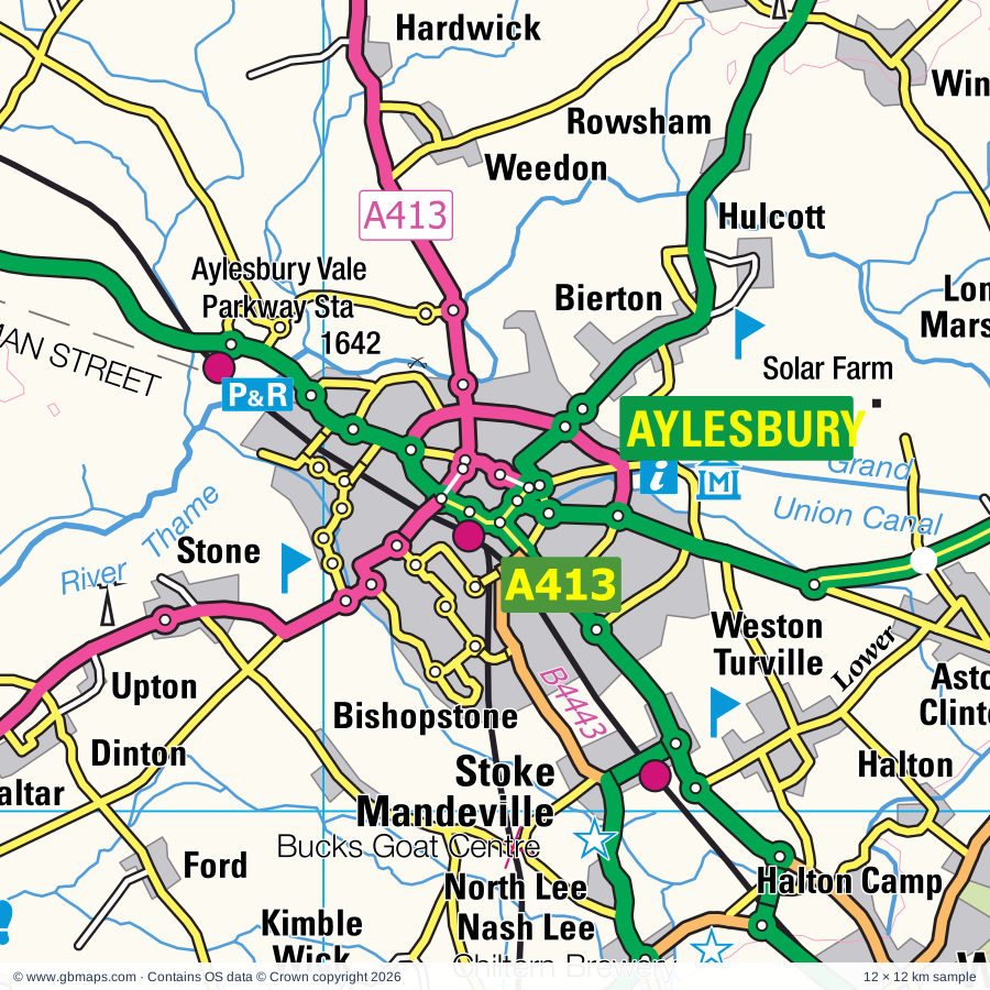
Aylesbury regional road map. Full 60 × 60 km PDF, SVG and Illustrator files, with a free PDF sample.

GBMAPS.COM

Aylesbury Regional Road Map

Call Us Now for Help01751 473136

GREAT BRITAIN ROAD ATLAS · 1:250,000 GB-480-0210

Aylesbury & surrounding area

Explore the full 60 × 60 km Aylesbury regional road map at 1:250,000, covering Wendover, Thame, Tring, Winslow, Chesham. Compare the complete coverage below; a detailed PDF sample is available free.

AYLESBURY & SURROUNDING AREAREGIONAL ROAD MAP
60 × 60 km · Full map previewDownload the free SVG ↓

INSIDE THE FULL 60 × 60 KM MAP

Explore the Aylesbury map area

1:250,000 cartography

Towns, villages & places

More mapped places (322)
  • Woburn Sands
  • Maidenhead
  • Didcot
  • Flitwick
  • Brackley
  • Ampthill
  • Bishopstone
  • Ford
  • Stone
  • North Lee
  • Upton
  • Dinton
  • Little Kimble
  • Owlswick
  • Meadle
  • Gibraltar
  • Nash Lee
  • Aston Sandford
  • Ellesborough
  • Askett
  • Longwick
  • Ilmer
  • Whiteleaf
  • Cuddington
  • Haddenham
  • Kingsey
  • Bierton
  • Lower Winchendon
  • Halton
  • Pitch Green
  • Forty Green
  • Bledlow
  • Dunsmore
  • Towersey
  • Saunderton
  • Weedon
  • Henton
  • Chearsley
  • Hulcott
  • Waddesdon
  • Buckland
  • Hardwick
  • Rowsham
  • Puttenham
  • Emmington
  • Chinnor
  • Lacey Green
  • Ashendon
  • Pitchcott
  • Westcott
  • Sydenham
  • Speen
  • Whitchurch
  • Easington
  • Wilstone
  • Chilton
  • St Leonards
  • Wingrave
  • Oving
  • Quainton
  • Crowell
  • Prestwood
  • Moreton
  • Hastoe
  • Creslow
  • Dorton
  • Radnage
  • Marsworth
  • Cublington
  • Bradenham
  • Cholesbury
  • Postcombe
  • South Heath
  • The City
  • Shabbington
  • Naphill
  • Tetsworth
  • Wigginton
  • Kingswood
  • Cheddington
  • Stokenchurch
  • Dunton
  • Chartridge
  • Mentmore
  • Adwell
  • Pitstone
  • Lewknor
  • Hoggeston
  • Wing
  • Brill
  • Asheridge
  • Ickford
  • Granborough
  • Bellingdon
  • Horton
  • Downley
  • Tiddington
  • Ivinghoe
  • Burcott
  • Piddington
  • Ledburn
  • Ludgershall
  • Botolph Claydon
  • Worminghall
  • Oakley
  • Milton Common
  • Aldbury
  • Stewkley
  • Waterstock
  • Ibstone
  • Hazlemere
  • Slapton
  • Edgcott
  • Swanbourne
  • Shirburn
  • Piddington
  • Waterperry
  • Pyrton
  • Boarstall
  • Great Haseley
  • Little Haseley
  • Calvert
  • Northend
  • Mursley
  • Easington
  • Ringshall
  • Billington
  • Soulbury
  • Lye Green
  • Fingest
  • Turville
  • Charndon
  • Addington
  • Frieth
  • Edlesborough
  • Botley
  • Cuxham
  • Orchard Leigh
  • Holton
  • Greenfield
  • Dagnall
  • Skirmett
  • Blackthorn
  • Wheatley
  • Hudnall
  • Coleshill
  • Chalgrove
  • Adstock
  • Cuddesdon
  • Twyford
  • Pishill
  • Bragenham
  • Ambrosden
  • Poundon
  • Loudwater
  • Eggington
  • Denton
  • Stanbridge
  • Nettleden
  • Hillesden
  • Totternhoe
  • Stonor
  • Padbury
  • Murcott
  • Bovingdon
  • Whipsnade
  • Maidensgrove
  • Stadhampton
  • Holywell
  • Studham
  • Tilsworth
  • Beckley
  • Launton
  • Latimer
  • Garsington
  • Newington
  • Fencott
  • Horspath
  • Flaunden
  • Chiselhampton
  • Hambleden
  • Merton
  • Fawley
  • Godington
  • Water End
  • Roke
  • Hockliffe
  • Nash
  • Ewelme
  • Whaddon
  • Jockey End
  • Thornborough
  • Kensworth
  • Gawcott
  • Greenlands
  • Chenies
  • Wooburn
  • Battlesden
  • Potsgrove
  • Chetwode
  • Nettlebed
  • Oddington
  • Jordans
  • Tebworth
  • Noke
  • Bisham
  • Benson
  • Chipperfield
  • Wendlebury
  • Wingfield
  • Aston
  • Bix
  • Warborough
  • Marsh Baldon
  • Elsfield
  • Medmenham
  • Remenham
  • Nuffield
  • Thornton
  • Cookham
  • Sarratt
  • Hurley
  • Commonwood
  • Caversfield
  • Woodeaton
  • Shillingford
  • Chesterton
  • Berinsfield
  • Bow Brickhill
  • Markyate
  • Highmoor
  • Bucks Hill
  • Tingewick
  • Radclive
  • Rucklers Lane
  • Dorchester
  • Beachampton
  • Fringford
  • Burcot
  • Islip
  • Crowmarsh Gifford
  • Bainton
  • Caddington
  • Finmere
  • Flamstead
  • Greys Green
  • Chackmore
  • Toddington
  • Leckhampstead
  • Fancott
  • Hethe
  • Chalton
  • Calverton
  • Bucknell
  • Hedgerley
  • Kennington
  • Akeley
  • Harpsden
  • Wavendon
  • Stoke Lyne
  • Hunton Bridge
  • Cottisford
  • Hardwick
  • Radley
  • Taplow
  • Wicken
  • Ipsden
  • North Stoke
  • Tingrith
  • Bedmond
  • Bletchingdon
  • Mixbury
  • Shalstone
  • Ardley
  • Bayworth
  • Dadford
  • Harlington
  • Westbury
  • Ridgmont
  • Fulmer
  • Juniper Hill
  • Cholsey
  • Harefield
  • Woodcote
  • Salford
  • Westoning
  • Caulcott
  • Culham
  • Streatley
  • Evenley
  • Steppingley
  • South Stoke
  • Sharpenhoe
  • Denham
  • Cray's Pond
  • Moulsford
  • Fritwell
  • Turweston
  • Eastbury
  • Lidlington
  • Northwood
  • Croughton
  • Souldern
  • Whitfield
  • Goring
  • Pulloxhill
  • Greenfield
  • Streatley
  • Millbrook
  • Blewbury
  • Uxbridge
  • Flitton
  • Upton
  • Aynho
  • Iver
  • Charlton
  • Maulden
  • Silsoe
  • Newbottle
  • Yiewsley
  • Farthinghoe
  • Clophill

Roads across this sheet

M1, M4, M25, M40, A4, A6, A40, A41, A308, A321, A329, A355, A404, A404(M), A405, A408, A411, A412, A413, A414, A415, A416, A417, A418

More road numbers

A420, A421, A422, A423, A437, A505, A507, A509, A1081, A4007, A4010, A4012, A4020, A4074, A4094, A4095, A4125, A4128, A4129, A4130, A4142, A4144, A4145, A4146, A4147, A4154, A4155, A4156, A4157, A4158, A4165, A4180, A4183, A4251, A4421, A5120, A5130, A5183, A5228, B416, B430, B465, B466, B467, B469, B470, B471, B474, B480, B481, B482, B483, B485, B486, B487, B488, B489, B530, B579, B655, B3026, B3027, B3028, B4009, B4011, B4012, B4015, B4016, B4027, B4030, B4031, B4032, B4033, B4034, B4100, B4150, B4440, B4441, B4442, B4443, B4444, B4445, B4447, B4493, B4495, B4505, B4506, B4526, B4540, B4541, B4635

Rivers & waterways

Abbey Stream, Back Water, Clifton Cut, Colne Brook, Culham Cut, Fray's River, Grand Union Canal, Grand Union Canal (Slough Arm), Grand Union Canal (Wendover Arm), Grand Union Canal (disused), Jubilee River, Oxford Canal

More waterways

River Cherwell, River Chess, River Colne, River Flit, River Gade, River Great Ouse, River Lea or Lee, River Misbourne, River Ouzel or Lovat, River Ray, River Thame, River Thames, River Thames or Isis

Landmarks & landscape

Abingdon Abbey, Amersham Museum, Ascott House, Ascott House and Gardens, Ashmolean, Museum of Natural History, Modern Art, Museum of Oxford, Bate Collection, Pitt Rivers Museum, BT, The Oxford Story, History of Science, Ashridge College, Ashridge Visitor Centre, Aston Rowant, Aynho Park, Battle of Britain Bunker, Bayhurst Wood Country Park, Bekonscot Model Village

More named features

Berkhamsted Castle, Bernwood Forest Nature Reserve, Bishops Wood Country Park, Black Park Country Park Visitor Centre, Bledlow Cross (Hill Figure), Bletchley Park, Boarstall Duck Decoy, Boarstall Tower, Brill Windmill, Buckinghamshire County Museum, Buckinghamshire Railway Centre, Bucks Goat Centre, Burnham Beeches Nature Reserve, Calvert Jubilee Nature Reserve, Chapel, Chenies Manor House, Chesham Museums Project, Chiltern Brewery, Chiltern Open Air Museum, Chiltern Valley Winery & Brewery, Chilterns Gateway Centre, Chinnor Hill Nature Reserve, Cholsey and Wallingford Railway, Christchurch Cathedral, Church Wood Nature Reserve, Claydon House, Cliveden, Coln Valley Visitor Centre, Courthouse, Craft Centre, De Grey Mausoleum, Denham Country Park, Didcot Railway Centre, Dorchester Abbey Museum, Dunstable Downs Country Park, Flitton Moor Nature Reserve, Flitwick Moor Nature Reserve, Ford End Watermill, Frogmore Paper Mill, Go Ape Black Park, Go Ape Wendover, Go Ape Woburn, Greys Court, Gulliver's (Milton Keynes), Haddenham Museum, Hampden's Monument, Harcourt Aboretum and Garden, Harry Potter World, Herb Farm and Maze, Horrocks Wood Nature Reserve, Houghton House (remains of), Hughenden Manor, Icknield Line Steam Railway, Island Farm Donkey Sanctuary, John Dony Field Centre, Kingston Blount Point to Point Racecourse, Lacey Green Windmill, Lake Farm County Park, Langley Park Country Park, Leighton Buzzard Light Railway, Little Wittenham Nature Reserve, Long Crendon Courthouse, Luton Museum & Art Gallery, Maharajah's Well, Marsworth Reservoir Nature Reserve, Mead Open Farm, Merlin's Wood Nature Reserve, Milton's Cottage, Model Farm, Museum, Nether Winchendon House, Nuffield Place, Odds Farm Park, Old Gaol Museum, Old Kiln, Oxford & Buckinghamshire Light Infantry Museum, Oxford Castle, Oxford University Botanic Gardens, Pann Mill, Spring Garden Arts Centre, Pendon Museum, Pitstone Windmill, Quainton Windmill, Radcliffe Camera, Oxford Castle, River and Rowing Museum, Roald Dahl Museum And Story Centre, Rowles Solar Farm, Ruislip Common Miniature Railway, Rushmere Country Park, Rycote Chapel, Shotover Country Park, Snakes and Ladders, Solar Farm, St James' Lake Nature Reserve, St Tiggywinkles, Stanley Spencer Gallery Museum, Stockgrove Country Park, Stockley Country Park, Stockwood Discovery Centre, Stonor House, Stowe House, Stowe Landscape Gardens, Stowe School, Sundon Hills Country Park, Ten Acre Wood Nature Reserve, The National Bowl, Three Rivers Museum of Local History, Thrift Farm Park, Tiddenfoot Wildlife Park, Toddington Manor, Totternhoe Knolls Nature Reserve, Tring Brewery, Waddesdon Manor, Waddesdon Manor and Garden, Wallingford Museum, Walter Rothschild Zoological Museum, Walton Hall, Warburg Nature Reserve, Waterperry Gardens, Watlington Hill, West Wycombe Park, West Wycombe Village and Hill, Whipsnade White Lion (Hill Figure), Whiteleaf Cross (Hill Figure), Wilstone Reservoir Nature Reserve, Woburn Abbey, Woburn Heritage Centre, Woburn Safari Park, Woodside Farm & Wild Fowl Park, Wrest Park, Wycombe Museum, Xscape (Milton Keynes), ZSL Whipsnade Zoo
Local authority & parish coverage

Wholly or partly within the full map rectangle. These boundaries are coverage information, not additional artwork layers.

  • BuckinghamshirePartly within
  • Central BedfordshirePartly within
  • Cherwell DistrictPartly within
  • Dacorum DistrictWholly within
  • Ealing London BoroPartly within
  • Hillingdon London BoroPartly within
  • LutonPartly within
  • Milton KeynesPartly within
  • North Hertfordshire DistrictPartly within
  • Oxford DistrictPartly within
  • SloughPartly within
  • South Oxfordshire DistrictPartly within
  • St. Albans DistrictPartly within
  • Three Rivers DistrictPartly within
  • Vale of White Horse DistrictPartly within
  • Watford DistrictPartly within
  • West BerkshirePartly within
  • West NorthamptonshirePartly within
  • Windsor and MaidenheadPartly within
  • WokinghamPartly within
Wards & electoral divisions 271 areas
  • Abbey Ward
  • Abbots Langley & Bedmond Ward (part)
  • Abingdon Abbey Northcourt Ward (part)
  • Abingdon Dunmore Ward (part)
  • Abingdon Peachcroft Ward
  • Adeyfield East Ward
  • Adeyfield West Ward
  • Aldbury and Wigginton Ward
  • Amersham & Chesham Bois Ward
  • Ampthill Ward (part)
  • Apsley and Corner Hall Ward
  • Ashridge Ward
  • Aspley & Woburn Ward
  • Aston Clinton & Weston Turville Ward
  • Aylesbury East Ward
  • Aylesbury North Ward
  • Aylesbury North West Ward
  • Aylesbury South East Ward
  • Aylesbury South West Ward
  • Aylesbury West Ward
  • Barnfield Ward
  • Barton & Sandhills Ward
  • Barton-le-Clay & Silsoe Ward (part)
  • Basildon Ward (part)
  • Baylis & Salt Hill Ward
  • Beaconsfield Ward
  • Beech Hill Ward
  • Belmont Ward
  • Belmore Ward (part)
  • Bennetts End Ward
  • Benson & Crowmarsh Ward
  • Berinsfield Ward
  • Berkhamsted Castle Ward
  • Berkhamsted East Ward
  • Berkhamsted West Ward
  • Berryfields, Buckingham Park & Watermead Ward
  • Bicester East Ward
  • Bicester North & Caversfield Ward
  • Bicester South & Ambrosden Ward
  • Bicester West Ward
  • Bierton, Kingsbrook & Wing Ward
  • Biscot Ward
  • Bisham & Cookham Ward
  • Blackbird Leys Ward
  • Bletchley Park & Fenny Stratford Ward
  • Bletchley South Ward
  • Bletchley West Ward
  • Blewbury & Harwell Ward (part)
  • Booker & Cressex Ward
  • Botley & Sunningwell Ward (part)
  • Bovingdon, Flaunden and Chipperfield Ward
  • Boxmoor Ward
  • Boyn Hill Ward (part)
  • Brackley Ward
  • Bradwell Ward (part)
  • Bramingham Ward
  • Britwell Ward
  • Broughton & Moulsoe Ward (part)
  • Buckingham Ward (part)
  • Burnham Ward (part)
  • Caddington Ward (part)
  • Campbell Park & Willen Ward (part)
  • Carfax & Jericho Ward
  • Castlefield & Oakridge Ward
  • Central Milton Keynes Ward
  • Central Ward
  • Chalfont St. Giles & Little Chalfont Ward
  • Chalfont St. Peter Ward
  • Chalgrove Ward
  • Challney Ward
  • Chalvey Ward (part)
  • Charville Ward (part)
  • Chaulden and Warners End Ward
  • Chesham North Ward
  • Chesham South Ward
  • Chiltern Villages Ward
  • Chinnor Ward
  • Cholsey Ward (part)
  • Chorleywood North & Sarratt Ward
  • Chorleywood South & Maple Cross Ward
  • Churchill Ward
  • Cippenham Green Ward
  • Cippenham Manor Ward (part)
  • Cippenham Village Ward (part)
  • Colham & Cowley Ward
  • Cowley Ward
  • Cox Green Ward (part)
  • Cranfield & Marston Moretaine Ward (part)
  • Cumnor Ward (part)
  • Cutteslowe & Sunnymead Ward (part)
  • Dallow Ward
  • Danesborough Ward
  • Deanshanger & Paulerspury Ward (part)
  • Deddington Ward (part)
  • Dickinsons Ward
  • Didcot North East Ward
  • Didcot South Ward
  • Didcot West Ward
  • Disraeli Ward
  • Donnington Ward
  • Downley Ward
  • Dunstable Central Ward
  • Dunstable East Ward
  • Dunstable North Ward
  • Dunstable South Ward
  • Dunstable West Ward
  • Durrants Ward
  • Eastcote Ward (part)
  • Eaton Bray Ward
  • Elliman Ward
  • Farley Ward
  • Farnham Ward
  • Farnhams & Stoke Poges Ward (part)
  • Flackwell Heath & The Wooburns Ward
  • Flitwick Ward
  • Forest Hill & Holton Ward
  • Fringford & Heyfords Ward (part)
  • Furze Platt Ward
  • Furzton Ward
  • Gade Valley Ward
  • Gadebridge Ward
  • Garsington & Horspath Ward
  • Gerrards Cross & Denham Ward
  • Goring Ward (part)
  • Great Linford Ward (part)
  • Grendon Underwood & The Claydons Ward
  • Grovehill Ward
  • Haddenham & Stone Ward
  • Harefield Village Ward
  • Harpenden North & Rural Ward (part)
  • Haseley Brook Ward
  • Hayes Town Ward (part)
  • Haymill Ward
  • Hazlemere Ward
  • Headington Hill & Northway Ward
  • Headington Ward
  • Heath & Reach Ward
  • Hemel Hempstead Town Ward
  • Henley-on-Thames Ward
  • High Town Ward (part)
  • Highfield Ward
  • Hillingdon East Ward (part)
  • Hillingdon West Ward
  • Hinksey Park Ward
  • Holywell Ward (part)
  • Holywell Ward
  • Horwood Ward
  • Houghton Conquest & Haynes Ward (part)
  • Houghton Regis East Ward
  • Houghton Regis West Ward
  • Hurley & Walthams Ward (part)
  • Ickenham & South Harefield Ward
  • Iver Ward (part)
  • Ivinghoe Ward
  • Kennington & Radley Ward
  • Kidlington East Ward (part)
  • Kidlington West Ward (part)
  • Kidmore End & Whitchurch Ward (part)
  • Kings Langley Ward
  • Langley Meads Ward (part)
  • Langley St. Mary's Ward (part)
  • Launton & Otmoor Ward (part)
  • Leagrave Ward
  • Leavesden Ward (part)
  • Leggatts Ward (part)
  • Leighton-Linslade North Ward
  • Leighton-Linslade South Ward
  • Leighton-Linslade West Ward
  • Leverstock Green Ward
  • Lewsey Ward
  • Littlemore Ward
  • Long Crendon Ward
  • Lye Valley Ward
  • Manor Park & Stoke Ward
  • Marlow Ward
  • Marsh & Micklefield Ward
  • Marston Ward
  • Meppershall & Shillington Ward (part)
  • Middleton Cheney Ward (part)
  • Moor Park & Eastbury Ward (part)
  • Nascot Ward (part)
  • Nash Mills Ward
  • Newton Longville Ward
  • Northborough & Lynch Hill Valley Ward
  • Northchurch Ward
  • Northfield Brook Ward
  • Northolt West End Ward (part)
  • Northwell Ward
  • Northwood Hills Ward (part)
  • Northwood Ward (part)
  • Offa Ward (part)
  • Oldfield Ward (part)
  • Osney & St Thomas Ward (part)
  • Ouzel Valley Ward
  • Oxhey Hall & Hayling Ward (part)
  • Park Ward (part)
  • Penn & Mill End Ward
  • Penn, Tylers Green & Loudwater Ward
  • Pinkneys Green Ward
  • Poets Ward
  • Princes Risborough Ward
  • Quainton Ward
  • Quarry & Risinghurst Ward
  • Redbourn Ward (part)
  • Rickmansworth Town Ward
  • Ridgeway East Ward
  • Ridgeway Ward (part)
  • Ridgeway West Ward
  • Riverside Ward
  • Rose Hill & Iffley Ward
  • Round Green Ward (part)
  • Ruislip Manor Ward (part)
  • Ruislip Ward (part)
  • Rural South Northamptonshire Ward (part)
  • Saints Ward
  • Sandford & the Wittenhams Ward (part)
  • Sands Ward
  • Shefford Ward (part)
  • Slough Central Ward (part)
  • Sonning Common Ward (part)
  • South Oxhey Ward (part)
  • South Ruislip Ward (part)
  • South Ward (part)
  • St. Clement's Ward
  • St. Mary's Ward
  • St. Mary's Ward
  • St. Stephen Ward (part)
  • Stanborough Ward (part)
  • Stony Stratford Ward (part)
  • Stopsley Ward (part)
  • Summertown Ward (part)
  • Sundon Park Ward
  • Sutton Courtenay Ward (part)
  • Tattenhoe Ward
  • Temple Cowley Ward
  • Terriers & Amersham Hill Ward
  • Thame Ward
  • Thames Ward (part)
  • The Missendens Ward
  • Toddington Ward (part)
  • Totteridge & Bowerdean Ward
  • Tring Central Ward
  • Tring East Ward
  • Tring West and Rural Ward
  • Upton Lea Ward (part)
  • Uxbridge Ward
  • Vauxhall Ward (part)
  • Verulam Ward (part)
  • Vicarage Ward (part)
  • Waddesdon Ward
  • Wallingford Ward
  • Walton Manor Ward
  • Walton Ward
  • Watling Ward
  • Watling Ward
  • Watlington Ward
  • Wendover, Halton & Stoke Mandeville Ward
  • West Drayton Ward (part)
  • West Wycombe & Lane End Ward
  • Westoning, Flitton & Greenfield Ward
  • Wexham Court Ward
  • Wheatley Ward
  • Winslow Ward
  • Wolvercote Ward (part)
  • Wolverton Ward (part)
  • Wood End Ward (part)
  • Woodcote & Rotherfield Ward
  • Woodhall Farm Ward
  • Woodside Ward (part)
  • Woughton & Fishermead Ward
  • Yiewsley Ward (part)
Civil parishes & communities 453 areas
  • Abbey Hill CP
  • Abbots Langley CP (part)
  • Abingdon on Thames CP (part)
  • Addington CP
  • Adstock CP
  • Adwell CP
  • Akeley CP
  • Aldbury CP
  • Aldworth CP (part)
  • Ambrosden CP
  • Amersham CP
  • Ampthill CP
  • Appleford-on-Thames CP
  • Ardley CP
  • Arncott CP
  • Ashendon CP
  • Ashley Green CP
  • Aspley Guise CP
  • Aspley Heath CP
  • Aston Abbotts CP
  • Aston Clinton CP
  • Aston Rowant CP
  • Aston Sandford CP
  • Aston Tirrold CP
  • Aston Upthorpe CP
  • Aylesbury CP
  • Aynho CP (part)
  • Barton Hartshorn CP
  • Barton-le-Clay CP (part)
  • Batchworth CP (part)
  • Battlesden CP
  • Beachampton CP
  • Beaconsfield CP
  • Beckley and Stowood CP
  • Benson CP
  • Berinsfield CP
  • Berkhamsted CP
  • Berrick Salome CP
  • Berryfields CP
  • Bicester CP
  • Biddlesden CP (part)
  • Bierton CP
  • Billington CP
  • Binfield Heath CP (part)
  • Bisham CP
  • Bix and Assendon CP
  • Blackbird Leys CP
  • Blackthorn CP
  • Bledlow-cum-Saunderton CP
  • Bletchingdon CP (part)
  • Bletchley and Fenny Stratford CP
  • Blewbury CP (part)
  • Boarstall CP
  • Botley and North Hinksey CP (part)
  • Bovingdon CP
  • Bow Brickhill CP
  • Brackley CP
  • Bradenham CP
  • Bradwell CP (part)
  • Bray CP (part)
  • Brightwell Baldwin CP
  • Brightwell-cum-Sotwell CP
  • Brill CP
  • Britwell CP
  • Britwell Salome CP
  • Brogborough CP (part)
  • Broughton Hamlet CP
  • Broughton and Milton Keynes CP (part)
  • Buckingham CP
  • Buckingham Park CP
  • Buckland CP
  • Bucknell CP
  • Burnham CP (part)
  • Caddington CP
  • Calvert Green CP
  • Calverton CP
  • Campbell Park CP (part)
  • Campton and Chicksands CP (part)
  • Caversfield CP
  • Central Milton Keynes CP (part)
  • Chalfont St. Giles CP
  • Chalfont St. Peter CP
  • Chalgrave CP
  • Chalgrove CP
  • Chalton CP
  • Charlton-on-Otmoor CP
  • Charndon CP
  • Chartridge CP
  • Chearsley CP
  • Checkendon CP
  • Cheddington CP
  • Chenies CP
  • Chepping Wycombe CP
  • Chesham Bois CP
  • Chesham CP
  • Chesterton CP
  • Chetwode CP
  • Chilton CP
  • Chinnor CP
  • Chipperfield CP
  • Cholesbury-cum-St. Leonards CP
  • Cholsey CP
  • Chorleywood CP
  • Clifton Hampden CP
  • Clophill CP (part)
  • Coldharbour CP
  • Coleshill CP
  • Compton CP (part)
  • Cookham CP
  • Cottisford CP
  • Cox Green CP (part)
  • Cranfield CP (part)
  • Creslow CP
  • Croughton CP
  • Crowell CP
  • Crowmarsh CP
  • Croxley Green CP
  • Cublington CP
  • Cuddesdon and Denton CP
  • Cuddington CP
  • Culham CP (part)
  • Cumnor CP (part)
  • Cuxham with Easington CP
  • Deanshanger CP (part)
  • Denham CP
  • Didcot CP
  • Dinton-with-Ford and Upton CP
  • Dorchester CP
  • Dorney CP (part)
  • Dorton CP
  • Downley CP
  • Drayton Beauchamp CP
  • Drayton Parslow CP
  • Drayton St. Leonard CP
  • Dunstable CP
  • Dunton CP
  • East Claydon CP
  • East Hagbourne CP
  • East Ilsley CP (part)
  • Eaton Bray CP
  • Edgcott CP
  • Edlesborough CP
  • Eggington CP
  • Ellesborough CP
  • Elsfield CP
  • Evenley CP
  • Eversholt CP
  • Ewelme CP
  • Fairfields CP
  • Farnham Royal CP
  • Farthinghoe CP (part)
  • Fawley CP
  • Fencott and Murcott CP
  • Finmere CP
  • Flamstead CP
  • Flaunden CP
  • Fleet Marston CP
  • Flitton and Greenfield CP
  • Flitwick CP
  • Forest Hill with Shotover CP
  • Foscott CP
  • Fringford CP
  • Fritwell CP
  • Fulmer CP
  • Garsington CP
  • Gawcott with Lenborough CP
  • Gerrards Cross CP
  • Godington CP
  • Goring Heath CP (part)
  • Goring-on-Thames CP (part)
  • Gosford and Water Eaton CP (part)
  • Granborough CP
  • Gravenhurst CP (part)
  • Great Brickhill CP
  • Great Gaddesden CP
  • Great Haseley CP
  • Great Horwood CP
  • Great Linford CP (part)
  • Great Marlow CP
  • Great Milton CP
  • Great Missenden CP
  • Great and Little Hampden CP
  • Great and Little Kimble cum Marsh CP
  • Greatworth and Halse CP (part)
  • Grendon Underwood CP
  • Haddenham CP
  • Halton CP
  • Hambleden CP
  • Hampton Gay and Poyle CP (part)
  • Hardwick CP
  • Hardwick with Tusmore CP
  • Harlington CP
  • Harpenden Rural CP (part)
  • Harpsden CP (part)
  • Harwell CP (part)
  • Haynes CP (part)
  • Hazlemere CP
  • Heath and Reach CP
  • Hedgerley CP
  • Hedsor CP
  • Henley-on-Thames CP
  • Hethe CP
  • Hexton CP (part)
  • Heyford Park CP
  • Highmoor CP
  • Hillesden CP
  • Hinton-in-the-Hedges CP
  • Hockliffe CP
  • Hoggeston CP
  • Hogshaw CP
  • Holton CP
  • Horspath CP
  • Horton-cum-Studley CP
  • Houghton Conquest CP (part)
  • Houghton Regis CP
  • Hughenden CP
  • Hulcote and Salford CP (part)
  • Hulcott CP
  • Hurley CP (part)
  • Husborne Crawley CP
  • Hyde CP (part)
  • Ibstone CP
  • Ickford CP
  • Ipsden CP
  • Islip CP
  • Iver CP (part)
  • Ivinghoe CP
  • Kennington CP
  • Kensworth CP
  • Kents Hill and Monkston CP
  • Kidlington CP (part)
  • Kidmore End CP (part)
  • Kings Langley CP
  • Kings Sutton CP (part)
  • Kingsbrook CP
  • Kingsey CP
  • Kingswood CP
  • Kirtlington CP (part)
  • Lacey Green CP
  • Lane End CP
  • Latimer and Ley Hill CP
  • Launton CP
  • Leckhampstead CP (part)
  • Leighton-Linslade CP
  • Lewknor CP
  • Lidlington CP (part)
  • Lilley CP (part)
  • Lillingstone Dayrell with Luffield Abbey CP (part)
  • Lillingstone Lovell CP (part)
  • Little Brickhill CP
  • Little Chalfont CP
  • Little Gaddesden CP
  • Little Horwood CP
  • Little Marlow CP
  • Little Milton CP
  • Little Missenden CP
  • Little Wittenham CP
  • Littlemore CP
  • Long Crendon CP
  • Long Wittenham CP
  • Longwick-cum-Ilmer CP
  • Loughton & Great Holm CP
  • Lower Heyford CP (part)
  • Ludgershall CP
  • Maids Moreton CP
  • Markyate CP
  • Marlow Bottom CP
  • Marlow CP
  • Marsh Baldon CP
  • Marsh Gibbon CP
  • Marston Moreteyne CP (part)
  • Marsworth CP
  • Maulden CP (part)
  • Medmenham CP
  • Mentmore CP
  • Merton CP
  • Middle Claydon CP
  • Middleton Cheney CP (part)
  • Middleton Stoney CP
  • Millbrook CP (part)
  • Milton Bryan CP
  • Mixbury CP
  • Moulsford CP
  • Moulsoe CP (part)
  • Mursley CP
  • Nash CP
  • Nash Mills CP
  • Nether Winchendon CP
  • Nettlebed CP
  • Nettleden with Potten End CP
  • Newbottle CP
  • Newington CP
  • Newton Longville CP
  • Newton Purcell with Shelswell CP
  • Noke CP
  • North Marston CP
  • North Moreton CP
  • Northchurch CP
  • Nuffield CP
  • Nuneham Courtenay CP
  • Oakley CP
  • Oddington CP
  • Old Marston CP
  • Old Stratford CP (part)
  • Old Woughton CP
  • Oving CP
  • Padbury CP
  • Penn CP
  • Piddington CP
  • Piddington and Wheeler End CP
  • Pishill with Stonor CP
  • Pitchcott CP
  • Pitstone CP
  • Potsgrove CP
  • Poundon CP
  • Preston Bissett CP
  • Princes Risborough CP
  • Pulloxhill CP
  • Pyrton CP
  • Quainton CP
  • Radclive-cum-Chackmore CP
  • Radley CP
  • Radnage CP
  • Radstone CP (part)
  • Redbourn CP (part)
  • Remenham CP
  • Ridgmont CP
  • Risinghurst and Sandhills CP
  • Rotherfield Greys CP
  • Rotherfield Peppard CP
  • Sandford-on-Thames CP
  • Sarratt CP
  • Seer Green CP
  • Shabbington CP
  • Shalstone CP (part)
  • Shenley Brook End CP
  • Shenley Church End CP
  • Shillington CP (part)
  • Shiplake CP (part)
  • Shirburn CP
  • Silsoe CP
  • Simpson and Ashland CP
  • Slapton CP
  • Slip End CP
  • Somerton CP (part)
  • Sonning Common CP (part)
  • Soulbury CP
  • Souldern CP (part)
  • South Hinksey CP (part)
  • South Moreton CP
  • South Stoke CP
  • St. Michael CP (part)
  • St. Stephen CP (part)
  • Stadhampton CP
  • Stanbridge CP
  • Stanton St. John CP
  • Stantonbury CP (part)
  • Steeple Claydon CP
  • Steppingley CP
  • Stewkley CP
  • Stoke Hammond CP
  • Stoke Lyne CP
  • Stoke Mandeville CP
  • Stoke Poges CP
  • Stoke Row CP
  • Stoke Talmage CP
  • Stokenchurch CP
  • Stone with Bishopstone and Hartwell CP
  • Stony Stratford CP (part)
  • Stowe CP (part)
  • Stratton Audley CP
  • Streatley CP (part)
  • Streatley CP (part)
  • Studham CP
  • Sundon CP
  • Sunningwell CP (part)
  • Sutton Courtenay CP (part)
  • Swanbourne CP
  • Swyncombe CP
  • Sydenham CP
  • Syresham CP (part)
  • Taplow CP (part)
  • Tetsworth CP
  • Thame CP
  • The Lee CP
  • Thornborough CP
  • Thornton CP
  • Tiddington-with-Albury CP
  • Tilsworth CP
  • Tingewick CP
  • Tingrith CP
  • Toddington CP
  • Toot Baldon CP
  • Totternhoe CP
  • Towersey CP
  • Tring CP
  • Tring Rural CP
  • Turville CP
  • Turweston CP
  • Twyford CP
  • Upper Heyford CP (part)
  • Upper Winchendon CP
  • Upton CP (part)
  • Waddesdon CP
  • Wallingford CP
  • Walton CP
  • Warborough CP
  • Wargrave CP (part)
  • Warkworth CP (part)
  • Water Stratford CP
  • Watermead CP
  • Waterperry with Thomley CP
  • Waterstock CP
  • Watford Rural CP (part)
  • Watlington CP
  • Wavendon CP
  • Weedon CP
  • Wendlebury CP
  • Wendover CP
  • West Bletchley CP
  • West Hagbourne CP (part)
  • West Wycombe CP
  • Westbury CP
  • Westcott CP
  • Western Valley CP (part)
  • Weston Turville CP
  • Weston-on-the-Green CP
  • Westoning CP
  • Wexham CP (part)
  • Wexham Court CP
  • Whaddon CP
  • Wheatfield CP
  • Wheatley CP
  • Whipsnade CP
  • Whitchurch CP
  • White Waltham CP (part)
  • Whitehouse CP
  • Whitfield CP (part)
  • Wicken CP (part)
  • Wigginton CP
  • Wing CP
  • Wingrave with Rowsham CP
  • Winslow CP
  • Woburn CP
  • Woburn Sands CP
  • Wolverton and Greenleys CP (part)
  • Wooburn CP
  • Woodcote CP
  • Woodeaton CP
  • Woodham CP
  • Worminghall CP
  • Wotton Underwood CP
  • Woughton CP

Source: the GBMaps road atlas, OS Boundary-Line and postcode mapping datasets. Source editions are being checked for publication. Unmarked boundary names are wholly within the sheet; “part” means the map edge crosses the area.

Place lists are selected from the map source, not a complete gazetteer. Named features describe the cartography; visitor facilities and opening status are not verified. The free sample covers only 12 × 12 km of this larger sheet.

INSIDE YOUR DOWNLOAD

A proper road map, in useful formats

Road classifications, towns and villages, railways, rivers, landscape detail and tourist symbols, brought together in the GBMaps regional road atlas style.

PDF filePDFSVG fileSVGAdobe Illustrator AI fileAi

PDF for the finished map. SVG and layered Illustrator artwork for adapting colours, adding your own information and preparing designs.

THE FINISHED SHEET

Designed for print and presentation

Map coverage
60 × 60 km
Sample coverage
12 × 12 km
Print layout
A3 landscape · enlarged 1:250k cartography
Sheet furniture
Border, scale bar, key & north arrow

A few useful details

What changes when I select another square?

Select a surrounding square to bring it into the centre and reveal the maps around it. Each square is a different 60 × 60 km map. The preview, free sample and selected download change together. Neighbouring sheets overlap by 30 km so you can choose the coverage that suits you.

Is the free sample a vector map?

The on-page detail is an SVG. The free download is a separate 12 × 12 km PDF with a link to the full map. Please retain its copyright credits and product link when sharing it.

Can I buy a larger combined map?

These downloads are individual ready-made sheets. Contact GBMaps if you need a larger combined area.

FREE PDF SAMPLE

Your free map sample

Your free 12 × 12 km sample includes a link back to this map, so you can return for the full area whenever you need it.

Download free PDF sample ↓

Get your Aylesbury map

Map download bundle

£24.00including VATOne payment

Pay securely

One payment. Your map stays open.

Your map download

Your map files

Preparing your download…

Checking your private download link…

Your map downloads

Already bought a map?

Find the downloads from your purchases.

Enter the email address you used at checkout. We’ll email you a private link to your available map downloads.