Free Birmingham PDF Map
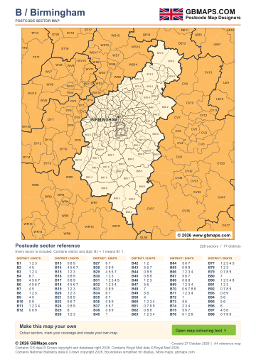
- Full B postcode-area coverage
- PDF with GBMaps branding
- Includes a map colouring tool link
PDF
FreePDF download
For non-commercial use
Birmingham postcode sector maps · Free PDF and complete map bundle
Welcome back
Access your saved maps and downloads.
Need help accessing your account? Contact GBMaps.
BIRMINGHAM POSTCODE SECTOR MAP DOWNLOADS
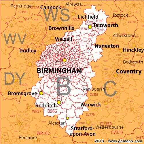
See the 228 postcode sector boundaries within the Birmingham (B) postcode area. Sectors divide districts into smaller areas for more detailed territory planning. Download the branded PDF free, or choose the complete bundle with a clean PDF, editable SVG and PNG, JPG and GIF images.
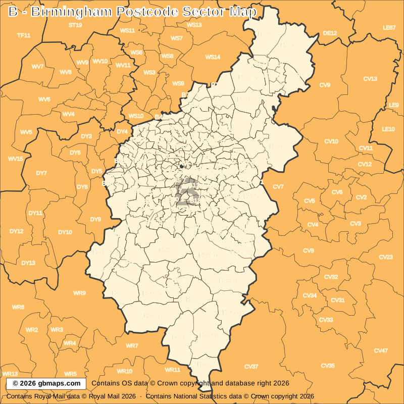
Explore the 228 mapped postcode sectors in the B postcode area. Download the free Birmingham postcode sector map as a PDF, or choose the complete map bundle with a clean PDF, editable SVG and PNG, JPG and GIF images.
FreePDF download
For non-commercial use
£12including VAT
£10 + £2 VAT · One-off payment
The free PDF needs no email, account or payment. The bundle includes all five formats in one ZIP. Required map-data copyright credits are retained in both versions.

POSTCODE SECTOR COLOURING TOOL
See B postcode sectors divided into 4 example territories, then use the online colouring tool to build a map for your sales or delivery areas.
Open the sector map colouring toolB POSTCODE SECTORS AND PLACES
These 117 sectors each introduce at least one named place or locality not already shown in this directory. The complete map contains 228 sectors. Names are matched to sectors and grouped by shared outward code.
| Sector | Local places |
|---|---|
| B1 postcode sectors | |
| B1 1 | Central Birmingham |
| B5 postcode sectors | |
| B5 7 | Edgbaston |
| B6 postcode sectors | |
| B6 4 | Aston |
| B6 6 | Witton |
| B7 postcode sectors | |
| B7 4 | Nechells |
| B8 postcode sectors | |
| B8 1 | Washwood Heath |
| B8 2 | Hodge Hill |
| B9 postcode sectors | |
| B9 4 | Bordesley |
| B11 postcode sectors | |
| B11 1 | Sparkbrook |
| B11 2 | Acocks Green |
| B11 4 | Sparkhill |
| B12 postcode sectors | |
| B12 9 | Balsall Heath |
| B13 postcode sectors | |
| B13 0 | Billesley, Springfield |
| B13 8 | Moseley |
| B14 postcode sectors | |
| B14 4 | Warstock |
| B14 6 | Brandwood |
| B14 7 | King's Heath |
| B15 postcode sectors | |
| B15 3 | Chad Valley |
| B16 postcode sectors | |
| B16 0 | Winson Green |
| B17 postcode sectors | |
| B17 0 | Harbourne |
| B17 8 | Quinton |
| B17 9 | Harborne |
| B18 postcode sectors | |
| B18 5 | Lozells |
| B20 postcode sectors | |
| B20 1 | Handsworth |
| B23 postcode sectors | |
| B23 5 | Erdington, Short Heath |
| B23 7 | Stockland Green, Gravelly Hill |
| B24 postcode sectors | |
| B24 0 | Tyburn |
| B25 postcode sectors | |
| B25 8 | Yardley |
| B26 postcode sectors | |
| B26 2 | Lyndon Green |
| B26 3 | Sheldon, Elmdon |
| B27 postcode sectors | |
| B27 7 | Acock's Green |
| B28 postcode sectors | |
| B28 0 | Hall Green |
| B29 postcode sectors | |
| B29 4 | Weoley Castle |
| B29 6 | Selly Oak |
| B30 postcode sectors | |
| B30 1 | Bournville |
| B30 2 | Stirchley |
| B30 3 | King's Norton |
| B31 postcode sectors | |
| B31 2 | Northfield, Longbridge |
| B31 3 | Kings Norton |
| B32 postcode sectors | |
| B32 3 | Bartley Green, Woodgate Valley |
| B32 4 | Woodgate, Frankley |
| B33 postcode sectors | |
| B33 0 | Stetchford, Tile Cross |
| B34 postcode sectors | |
| B34 7 | Castle Bromwich |
| B37 postcode sectors | |
| B37 5 | Chelmsley Wood |
| B37 7 | Marston Green |
| B38 postcode sectors | |
| B38 0 | Birmingham |
| B40 postcode sectors | |
| B40 1 | National Exhibition Centre |
| B42 postcode sectors | |
| B42 1 | Perry Barr |
| B42 2 | Great Barr |
| B43 postcode sectors | |
| B43 5 | Hamstead |
| B43 7 | Pheasey |
| B44 postcode sectors | |
| B44 0 | Kingstanding |
| B44 8 | Old Oscott |
| B45 postcode sectors | |
| B45 8 | Barnt Green, Cofton Hackett, Lickey |
| B45 9 | Rubery |
| B46 postcode sectors | |
| B46 1 | Coleshill, Cole End, Water Orton |
| B46 2 | Shustoke, Church End, Hoggrill's End, Maxstoke, Nether Whitacre, Over Whitacre |
| B47 postcode sectors | |
| B47 5 | Hollywood |
| B47 6 | Wythall |
| B48 postcode sectors | |
| B48 7 | Alvechurch, Hopwood, Rowney Green, Weatheroak Hill |
| Sector | Local places |
|---|---|
| B49 postcode sectors | |
| B49 5 | Alcester, Arrow, Coughton, Dunnington, King's Coughton, Cookhill |
| B49 6 | Alne End, Ardens Grafton, Exhall, Great Alne |
| B50 postcode sectors | |
| B50 4 | Bidford-On-Avon, Barton, Broom, Marlcliff |
| B60 postcode sectors | |
| B60 1 | Catshill, Blackwell, Lickey End, Marlbrook |
| B60 2 | Bromsgrove, Aston Fields |
| B60 3 | Tardebigge, Tutnall |
| B60 4 | Stoke Wharf, Hanbury, Stoke Heath, Stoke Prior, Woolmere Green |
| B61 postcode sectors | |
| B61 0 | Upper Catshill |
| B61 7 | Upton Warren |
| B61 9 | Fairfield, Bournheath, Dodford |
| B62 postcode sectors | |
| B62 0 | Halesowen, Illey, Romsley |
| B62 9 | Blackheath |
| B64 postcode sectors | |
| B64 5 | Rowley Regis |
| B64 7 | Cradley Heath |
| B66 postcode sectors | |
| B66 1 | Smethwick |
| B67 postcode sectors | |
| B67 5 | Warley |
| B68 postcode sectors | |
| B68 0 | Brandhall |
| B68 8 | Langley Green |
| B69 postcode sectors | |
| B69 1 | Oldbury |
| B69 4 | Langley |
| B70 postcode sectors | |
| B70 0 | West Bromwich |
| B72 postcode sectors | |
| B72 1 | Sutton Coldfield, Royal Sutton Coldfield, Wylde Green |
| B73 postcode sectors | |
| B73 5 | New Oscott |
| B74 postcode sectors | |
| B74 2 | Mere Green |
| B74 3 | Streetly, Little Aston |
| B74 4 | Four Oaks |
| B75 postcode sectors | |
| B75 6 | Roughley |
| B76 postcode sectors | |
| B76 0 | Lea Marston, Marston |
| B76 1 | Walmley |
| B76 9 | Minworth, Curdworth, Over Green, Wishaw |
| B77 postcode sectors | |
| B77 1 | Tamworth, Dosthill, Kettlebrook |
| B77 4 | Amington |
| B77 5 | Wilnecote |
| B78 postcode sectors | |
| B78 1 | Dordon, Polesworth |
| B78 2 | Kingsbury, Middleton |
| B78 3 | Fazeley, Bonehill, Drayton Bassett, Hints, Hopwas, Two Gates |
| B79 postcode sectors | |
| B79 0 | Warton, Clifton Campville, Thorpe Constantine, Alvecote, Newton Regis, No Man's Heath |
| B79 9 | Edingale, Elford, Harlaston, Haunton, Wigginton |
| B80 postcode sectors | |
| B80 7 | Studley, Mappleborough Green, Morton Bagot |
| B90 postcode sectors | |
| B90 1 | Dickens Heath, Whitlock's End, Major's Green |
| B90 2 | Shirley |
| B90 4 | Cheswick Green, Monkspath |
| B91 postcode sectors | |
| B91 1 | Solihull |
| B91 2 | Elmdon Heath |
| B92 postcode sectors | |
| B92 0 | Hampton In Arden, Barston, Bickenhill, Eastcote |
| B92 7 | Olton |
| B93 postcode sectors | |
| B93 0 | Dorridge, Chadwick End, Knowle, Baddesley Clinton |
| B93 9 | Bentley Heath, Copt Heath |
| B94 postcode sectors | |
| B94 5 | Tanworth-In-Arden, Earlswood, Lapworth, Nuthurst, Portway, Terry's Green |
| B94 6 | Hockley Heath, Kingswood |
| B95 postcode sectors | |
| B95 5 | Henley-In-Arden, Lowsonford, Oldberrow, Preston Bagot, Preston Green, Ullenhall |
| B95 6 | Wootton Wawen, Aston Cantlow, Edstone, Little Alne, Newnham |
| B96 postcode sectors | |
| B96 6 | Astwood Bank, Sambourne, Bradley Green, Feckenham, Holberrow Green, New End |
| B97 postcode sectors | |
| B97 4 | Redditch |
| B97 5 | Crabbs Cross, Ham Green, Headless Cross, Hunt End, Upper Bentley |
| B98 postcode sectors | |
| B98 0 | Winyates |
| B98 9 | Beoley, Holt End |
This is a place finder, not a list of every sector or address. A name appears once even when it spans several sectors. Use a current full postcode to check an address.
The free PDF is for non-commercial use and includes GBMaps branding and a map colouring tool link. The paid bundle includes a commercial-use licence, without promotional watermarks or tool links. Required map-data and GBMaps copyright credits remain. Email us about commercial use Map licence terms · Digital delivery and returns.