Whitworth regional road map. Full 60 × 60 km PDF, SVG and Illustrator files, with a free PDF sample.

GBMAPS.COM

Whitworth Regional Road Map

Call Us Now for Help01751 473136

GREAT BRITAIN ROAD ATLAS · 1:250,000 RY-12

Whitworth & surrounding area

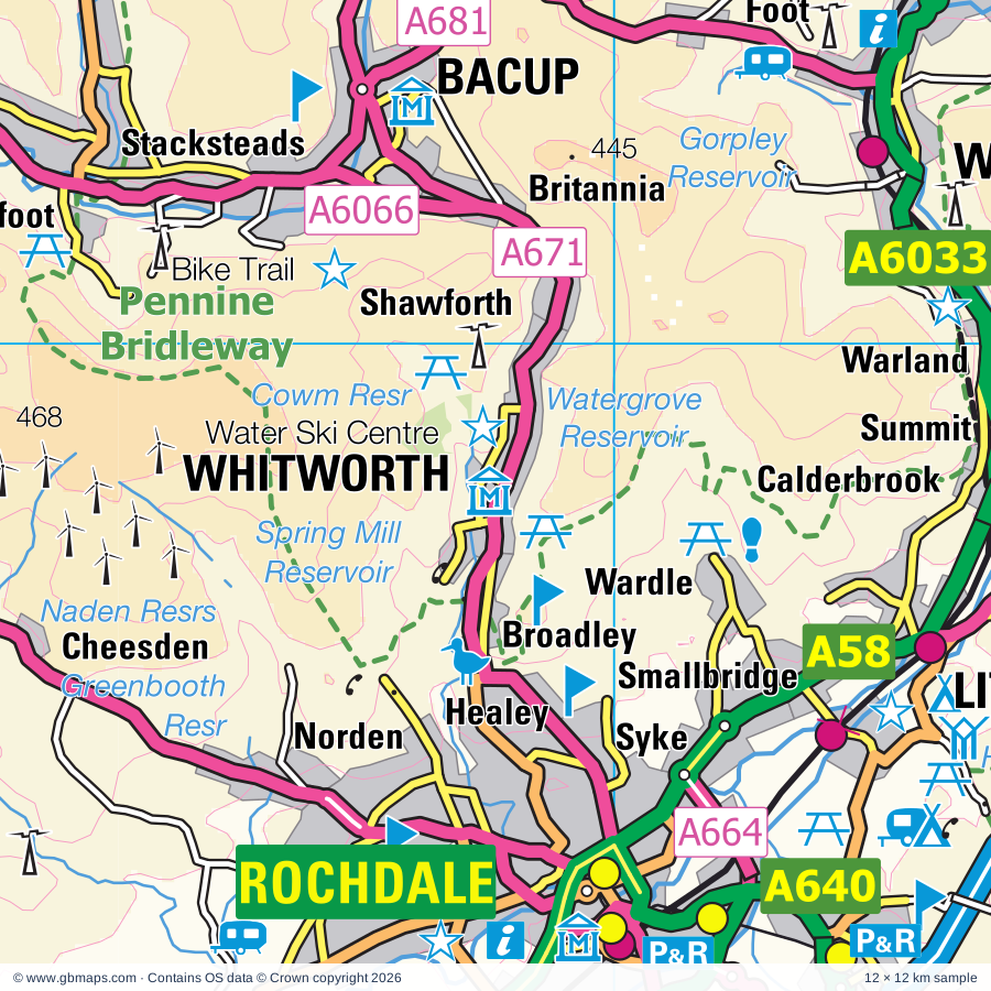
Explore the full 60 × 60 km Whitworth regional road map at 1:250,000, covering Whitworth, Bacup, Littleborough, Todmorden, Rochdale. Compare the complete coverage below; a detailed PDF sample is available free.

WHITWORTH & SURROUNDING AREAREGIONAL ROAD MAP
60 × 60 km · Full map previewDownload the free SVG ↓

INSIDE THE FULL 60 × 60 KM MAP

Explore the Whitworth map area

1:250,000 cartography

Towns, villages & places

More mapped places (232)

Roads across this sheet

M6, M60, M61, M62, M65, M66, M67, M602, M606, A6, A34, A49, A50, A56, A57, A57(M), A58, A59, A62, A65, A560, A572, A573, A574

More road numbers

A575, A576, A577, A578, A579, A580, A616, A624, A626, A627, A627(M), A628, A629, A635, A638, A640, A641, A642, A643, A644, A646, A647, A649, A650, A651, A657, A658, A659, A660, A662, A663, A664, A665, A666, A667, A669, A670, A671, A672, A673, A674, A675, A676, A677, A678, A679, A680, A681, A682, A5014, A5063, A5066, A5067, A5079, A5081, A5082, A5103, A5145, A5181, A5184, A5185, A5186, A6010, A6016, A6017, A6018, A6024, A6025, A6026, A6027, A6033, A6034, A6035, A6036, A6037, A6038, A6041, A6042, A6043, A6044, A6045, A6046, A6047, A6048, A6050, A6052, A6053, A6060, A6061, A6062, A6066, A6068, A6077, A6078, A6099, A6104, A6107, A6114, A6119, A6131, A6139, A6140, A6142, A6143, A6144, A6145, A6176, A6177, A6181, A6185, A6193, B5093, B5095, B5117, B5158, B5165, B5166, B5167, B5169, B5207, B5210, B5211, B5212, B5213, B5214, B5215, B5217, B5218, B5219, B5224, B5228, B5229, B5230, B5231, B5232, B5235, B5236, B5237, B5238, B5239, B5256, B5269, B5311, B5320, B5397, B5408, B5465, B5471, B6104, B6105, B6106, B6107, B6108, B6109, B6110, B6111, B6112, B6113, B6114, B6116, B6118, B6119, B6120, B6121, B6130, B6138, B6141, B6142, B6143, B6144, B6145, B6146, B6147, B6149, B6151, B6153, B6160, B6167, B6169, B6170, B6172, B6174, B6175, B6176, B6177, B6178, B6180, B6186, B6187, B6189, B6190, B6191, B6192, B6194, B6195, B6196, B6197, B6198, B6199, B6202, B6203, B6204, B6205, B6206, B6207, B6208, B6209, B6212, B6213, B6214, B6215, B6216, B6218, B6219, B6221, B6222, B6223, B6224, B6225, B6226, B6227, B6230, B6231, B6232, B6234, B6235, B6236, B6237, B6238, B6239, B6240, B6243, B6244, B6245, B6246, B6247, B6248, B6249, B6250, B6251, B6252, B6265, B6266, B6269, B6292, B6377, B6379, B6380, B6381, B6382, B6383, B6390, B6391, B6393, B6402, B6429, B6431, B6432, B6433, B6434, B6445, B6447, B6452, B6468, B6469, B6472, B6473, B6477, B6478, B6527, B6535, B6536
Rivers & waterways

Abbey Brook, Arnfield Brook, Ashton Canal, Bridgewater Canal, Calder & Hebble Navigation, Canal, Hebden Water, Huddersfield Broad Canal, Huddersfield Narrow Canal, Leeds & Liverpool Canal, Manchester Ship Canal, Manchester, Bolton & Bury Canal (disused)

More waterways

Manchester, Bolton and Bury Canal (disused), Peak Forest Canal, River Aire, River Alport, River Ashop, River Calder, River Darwen, River Derwent, River Don, River Etherow, River Goyt, River Hodder, River Irwell, River Mersey, River Ribble, River Roch, River Tame, River Wharfe, River Worth, Rochdale Canal, Sabden Brook, Tosside Beck

Landmarks & landscape

Abbey, Aisled Barn Visitor Centre, Animal World, Astley Cheetham Art Gallery, Astley Green Colliery Museum, Bacup Museum, Baildon Craft Centre, Bancroft Mill, Bankfield Museum, Bath House, Belle Vue Stadium, Bingley Five Rise Locks, PEAK DISTRICT NATIONAL PARK

More named features

Blackburn Cathedral, Blackleach Country Park & Visitor Centre, Boggart Hole Clough Visitor Centre, Bolling Hall Museum, Bolton Aquarium, Bolton Museum, Art Gallery, Aquarium, Booth House Gallery Ceramics, Bracken Hall Countryside Centre, Shipley Glen Tramway, Bradford Cathedral, Bradford Industrial Museum & Horses at Work, Bronte Parsonage Museum, Bronte Weaving Shed, Brownhill Visitor Centre, Browsholme Hall, Burrs Country Park, Cartwright Hall Art Gallery and Museum, Centre Vale Park, Chadkirk Chapel, Chipping Wild Boar Park, Chorlton Water Park, Chorlton Water Sports, Chorlton Water Park (Fishing), City of Manchester Stadium, Egerton Narrow Boats, The Manchester Evening News Arena, Chetham's Library, National Cycling Centre, Cliffe Castle, Keighley Bus Museum, Clifton Country Park, Clifton Country Park Visitor Centre, Wet Earth Colliery, Clitheroe Castle, Clitheroe Castle Museum, Close Gate Bridge, Clough Head Visitor Centre, Colne Valley Museum, Copper Dragon Brewery Visitor Centre, Crimsworth Dean, Cromwells Bridge, Daisy Nook Country Park, Dean Clough Gallery, Square Chapel Centre for the Arts, Piece Hall Arts Gallery, Earby Museum Of Mines, East Lancashire Railway, East Riddlesden Hall, Esplanade Arts and Heritage Centre, Touchstones Rochdale, Etherow Country Park, Eureka The Museum for Children, Fletcher Moss Botanical and Parsonage Gardens, Foulridge Wharf, Gallery of English Costume, Garden, Gawthorpe Hall, Go Ape Rivington, Goodshaw Chapel, Haigh Country Park, Hall, Hall i'th Wood, Hardcastle Crags, Haworth Art Galleries, Healey Dell Nature Reserve, Heaton Hall, Heaton Park, Heaton Park Animal Centre, Heaton Park Tram Museum, Helmshore Textile Museum, Heptonstall, Higher & Lower Holme House Woods, Historic Milestones, Hoghton Tower, Hollingworth Lake Activity Centre, Hollingworth Lake Country Park, Hollingworth Nature Reserve, Horton Bank Country Park, Horwich Heritage Centre, Imperial War Museum North, John Howarth Visitor Centre, Jumbles Country Park, Keighley & Worth Valley Railway, Lancashire Fusiliers Regimental Museum, Bury Art Gallery and Museum, Bury Transport Museum, Lancaster Park Animal Farm, Lewes Garden Nature Reserve, Lewis Textile Museum & Blackburn Museum & Art Gallery, Littleborough Coach House Heritage Centre, Lower Higham Visitor Centre, Lumb Hole Waterfall, Manchester C of E Cathedral, Manchester City Art Gallery, Museum of Science & Industry, The Pump House (Peoples History Museum), Manchester Swimming Complex, Manchester United Museum, Ordsall Hall Museum, Manor Heath Park Garden, Manor House Museum (Ilkley Manor House), Megabowl Bowling Alley, Mersey Valley Visitor Centre, Cloverfield Riding Centre, Moses Gate Country Park, Mrs Dowsons Ice Cream, Museum of Transport, Manchester Jewish Museum, Urbis, National Media Museum, Nelson Pit Visitor Centre, Ogden Water Country Park, Ogden Water Visitor Centre, Oldham Art Gallery and Museum, Oswaldtwistle Mills, Park Bridge Heritage Centre, Peel Tower, Penistone Hill Country Park, Pennington Flash Country Park, Pennington Flash Country Park Visitor Centre, Planet Earth Centre, Platform 4 Model Transport Museum, Platform Gallery, Pleasington Nature Reserve, Portland Basin Museum, The Museum of the Manchesters, Queen Street Mill, ROMAN FORT, Railway Carriage Museum, Ramsbottom Heritage Gallery, Reddish Vale Country Park, Reddish Vale Farm, Ribchester Roman Museum, Risley Moss Nature Park, Rivington Country Park, Rixton Claypits Nature Reserve, Rochdale Pioneers Museum, Greater Manchester Fire Service Museum, Roddlesworth Visitor Centre, Rossendale Museum, Saddleworth Museum & Art Gallery, Sale Water Park, Salford Art Gallery and Museum, Viewpoint Photography Gallery, Saltaire (World Heritage Site), Samlesbury Hall, Sawley Abbey, Shibden Hall, Shibden Park, Smith Art Gallery, Smithhills Open Farm, Smithills Country Park, Smithills Hall, Stalybridge Country Park, Standedge Visitor Centre, Steam Train Museum, Stonyhurst College, Stonyhurst College Garden, Stoodley Pike Monument, Sunnyhurst Wood Visitor Centre, Tandle Hill Country Park, Textile Museum, The Corgi Heritage Centre, The Last Drop Village, The Last of the Summer Wine Exhibition, The Manchester Museum, Pankhurst Centre, Whitworth Art Gallery, The Museum of Hatting, Stockport Air Raid Shelters, Stockport Heritage Centre, The Singing Ringing Tree, The Theatre Organ Heritage Centre, The Weavers Triangle Visitor Centre, The Whitworth Museum, Thornton Hall Farm, Throstle Nest Pottery, Tolson Museum, Tower, Towneley Hall, Trafford Park Heritage Centre, HMS Bronington, The Lowry, Turton Tower, Upper Derwent Reservoirs, Victoria Tower, Visitor & Canal Centre, Visitor Centre, Walley Abbey Visitor Centre, Warrington Indoor Tennis Centre, Water Ski Centre, Weavers Cottage, Lamberts Mill Footwear Museum, Wellybobs, Werneth Low Country Park Visitor Centre, Whalley Abbey Gatehouse, Witton Park Country Park, Woodbank Park Nature Reserve, Wycoller Country Park, Yorkshire Craft Centre

Local authority & parish coverage

Wholly or partly within the full map rectangle. These boundaries are coverage information, not additional artwork layers.

  • Barnsley DistrictPartly within
  • Blackburn with DarwenWholly within
  • Bolton DistrictPartly within
  • Bradford DistrictPartly within
  • Burnley DistrictWholly within
  • Bury DistrictWholly within
  • Calderdale DistrictWholly within
  • Chorley DistrictPartly within
  • High Peak DistrictPartly within
  • Hyndburn DistrictWholly within
  • Kirklees DistrictPartly within
  • Leeds DistrictPartly within
  • Manchester DistrictPartly within
  • North YorkshirePartly within
  • Oldham DistrictWholly within
  • Pendle DistrictPartly within
  • Preston DistrictPartly within
  • Ribble Valley DistrictPartly within
  • Rochdale DistrictWholly within
  • Rossendale DistrictWholly within
  • Salford DistrictWholly within
  • Sheffield DistrictPartly within
  • South Ribble DistrictPartly within
  • St. Helens DistrictPartly within
  • Stockport DistrictPartly within
  • Tameside DistrictWholly within
  • Trafford DistrictPartly within
  • WarringtonPartly within
  • Wigan DistrictPartly within
Wards & electoral divisions 395 areas
  • Abram Ward (part)
  • Adlington & Anderton Ward (part)
  • Airedale Ward (part)
  • Alexandra Ward
  • Almondbury Ward (part)
  • Alston & Hothersall Ward (part)
  • Altham Ward
  • Ancoats & Beswick Ward
  • Ardwick Ward
  • Ashbrow Ward
  • Ashton Hurst Ward
  • Ashton St. Michael's Ward
  • Ashton Waterloo Ward
  • Ashton upon Mersey Ward
  • Aspull, New Springs & Whelley Ward (part)
  • Astley Bridge Ward
  • Astley Ward
  • Atherton North Ward
  • Atherton South & Lilford Ward
  • Audenshaw Ward
  • Audley & Queen's Park Ward
  • Bacup Ward
  • Baildon Ward
  • Balderstone & Kirkholt Ward
  • Bamford Ward
  • Bank Hall Ward
  • Barnfield Ward
  • Barnoldswick Ward (part)
  • Barrowford & Pendleside Ward
  • Barton & Winton Ward
  • Bastwell & Daisyfield Ward
  • Baxenden Ward
  • Besses Ward
  • Bewsey & Whitecross Ward (part)
  • Billinge & Beardwood Ward
  • Billington & Langho Ward
  • Bingley East Ward
  • Bingley West Ward
  • Birchwood Ward
  • Birstall & Birkenshaw Ward (part)
  • Blackburn Central Ward
  • Blackburn South & Lower Darwen Ward
  • Blackburn South East Ward
  • Blackfriars & Trinity Ward
  • Bolton & Undercliffe Ward
  • Boothstown & Ellenbrook Ward
  • Boulsworth & Foulridge Ward
  • Bowdon Ward (part)
  • Bowland Ward (part)
  • Bowling & Barkerend Ward
  • Bradford Moor Ward
  • Bradley Ward
  • Bradshaw Ward
  • Bredbury & Woodley Ward
  • Bredbury Green & Romiley Ward (part)
  • Breightmet Ward
  • Briercliffe Ward
  • Brierfield East & Clover Hill Ward
  • Brierfield West & Reedley Ward
  • Brighouse Ward
  • Brinnington & Stockport Central Ward (part)
  • Britannia & Lee Mill Ward
  • Broadheath Ward (part)
  • Brockhall & Dinckley Ward
  • Bromley Cross Ward
  • Brooklands Ward (part)
  • Brooklands Ward
  • Broughton Ward
  • Brunshaw Ward
  • Bucklow-St. Martins Ward
  • Burnage Ward
  • Burtonwood & Winwick Ward (part)
  • Bury East Ward
  • Bury West Ward
  • Cadishead & Lower Irlam Ward
  • Calverley & Farsley Ward (part)
  • Castleton Ward
  • Central Rochdale Ward
  • Central Ward
  • Chadderton Central Ward
  • Chadderton North Ward
  • Chadderton South Ward
  • Charlestown Ward
  • Chatburn Ward
  • Cheadle East & Cheadle Hulme North Ward (part)
  • Cheetham Ward
  • Chipping Ward (part)
  • Chorley East Ward (part)
  • Chorley North & Astley Ward (part)
  • Chorley North East Ward (part)
  • Chorley South East & Heath Charnock Ward (part)
  • Chorlton Park Ward
  • Chorlton Ward
  • Church Ward
  • City Ward
  • Claremont Ward
  • Clayton & Fairweather Green Ward
  • Clayton & Openshaw Ward
  • Clayton East, Brindle & Hoghton Ward (part)
  • Clayton-le-Dale & Salesbury Ward
  • Clayton-le-Moors Ward
  • Cleckheaton Ward (part)
  • Cliviger with Worsthorne Ward
  • Coal Clough with Deerplay Ward
  • Coldhurst Ward
  • Colne Valley East Ward
  • Colne Valley West Ward
  • Coupe Green & Gregson Lane Ward (part)
  • Crompton Ward
  • Crosland Moor Ward
  • Crumpsall Ward
  • Culcheth, Glazebury & Croft Ward
  • Dalton Ward
  • Daneshouse with Stoneyholme Ward
  • Darwen East Ward
  • Darwen South Ward
  • Darwen West Ward
  • Davyhulme Ward
  • Deansgate Ward
  • Denby Dale Ward (part)
  • Denton North East Ward
  • Denton South Ward
  • Denton West Ward
  • Derby & Thornley Ward (part)
  • Didsbury East Ward (part)
  • Didsbury West Ward
  • Dilworth Ward
  • Dinting Ward
  • Droylsden East Ward
  • Droylsden West Ward
  • Dukinfield Stalybridge Ward
  • Dukinfield Ward
  • Earby & Coates Ward
  • East Middleton Ward
  • East Whalley, Read & Simonstone Ward
  • Eccles Ward
  • Eccleshill Ward
  • Edgeley Ward (part)
  • Edisford & Low Moor Ward
  • Elland Ward
  • Elton Ward
  • Ewood Ward
  • Failsworth East Ward
  • Failsworth West Ward
  • Fallowfield Ward
  • Farnworth North Ward
  • Farnworth South Ward
  • Fence & Higham Ward
  • Flixton Ward
  • Gamesley Ward
  • Gannow Ward
  • Gawthorpe Ward
  • Gisburn & Rimington Ward (part)
  • Golborne & Lowton West Ward (part)
  • Goodshaw & Cribden Ward
  • Gorse Hill & Cornbrook Ward
  • Gorton & Abbey Hey Ward
  • Great Horton Ward
  • Great Lever Ward
  • Greenfield & Eden Ward
  • Greenhead Ward
  • Greetland Ward
  • Guiseley & Rawdon Ward (part)
  • Hadfield North Ward
  • Hadfield South Ward
  • Halifax Town Ward
  • Halliwell Ward
  • Hapton with Park Ward
  • Hareholme & Waterfoot Ward
  • Harpurhey Ward
  • Haslingden Ward
  • Hayfield Ward (part)
  • Healey Ward
  • Heaton & Frizinghall Ward
  • Heaton, Lostock & Chew Moor Ward
  • Heatons North Ward
  • Heatons South Ward (part)
  • Hebden Bridge & Todmorden East Ward
  • Heckmondwike Ward (part)
  • Helmshore Ward
  • Higher Blackley Ward
  • Higher Irlam & Peel Green Ward
  • Hindley Green Ward
  • Hindley Ward
  • Hipperholme & Lightcliffe Ward
  • Hollinwood Ward
  • Holme Valley North Ward
  • Holme Valley South Ward
  • Holme Wood & Bierley Ward (part)
  • Holyrood Ward
  • Hope Valley Ward (part)
  • Hopwood Hall Ward
  • Horsforth Ward (part)
  • Horwich North Ward
  • Horwich South & Blackrod Ward (part)
  • Howard Town Ward
  • Hulme Ward
  • Hulton Ward
  • Huncoat Ward
  • Hurst Green & Whitewell Ward (part)
  • Hyde Godley Ward
  • Hyde Newton Ward
  • Hyde Werneth Ward
  • Idle & Thackley Ward (part)
  • Ilkley & Addingham Ward (part)
  • Illingworth & Mixenden Ward
  • Immanuel Ward
  • Ince Ward (part)
  • Kearsley Ward
  • Keighley Central Ward
  • Keighley East Ward
  • Keighley West Ward
  • Kersal & Broughton Park Ward
  • Kingsway Ward
  • Kirkburton Ward (part)
  • Lanehead Ward
  • Leigh Central & Higher Folds Ward
  • Leigh South Ward
  • Leigh West Ward
  • Levenshulme Ward
  • Lindley Ward
  • Little Harwood & Whitebirk Ward
  • Little Horton Ward
  • Little Hulton Ward
  • Little Lever & Darcy Lever Ward
  • Littleborough Lakeside Ward
  • Littlemoor Ward
  • Liversedge & Gomersal Ward (part)
  • Livesey with Pleasington Ward
  • Longdendale Ward
  • Longford Ward
  • Longholme Ward
  • Longsight Ward
  • Lostock & Barton Ward
  • Lowton East Ward
  • Luddendenfoot Ward
  • Manningham Ward
  • Manor Ward (part)
  • Manor Ward
  • Marple North Ward (part)
  • Marsden & Southfield Ward
  • Medlock Vale Ward
  • Mellor Ward
  • Miles Platting & Newton Heath Ward
  • Milkstone & Deeplish Ward
  • Mill Hill & Moorgate Ward
  • Milnrow & Newhey Ward
  • Milnshaw Ward
  • Mirfield Ward (part)
  • Moorside Ward
  • Moss Side Ward
  • Mossley Ward
  • Moston Ward
  • Netherton & Newsome Ward
  • Netherton Ward
  • Newton-le-Willows East Ward (part)
  • Norden Ward
  • North Heywood Ward
  • North Manor Ward
  • North Middleton Ward
  • Northenden Ward (part)
  • Northowram & Shelf Ward
  • Old Glossop Ward
  • Old Moat Ward
  • Old Trafford Ward
  • Ordsall Ward
  • Orford Ward (part)
  • Otley & Yeadon Ward (part)
  • Ovenden Ward
  • Overton Ward
  • Padfield Ward
  • Park Ward
  • Peel Ward
  • Pendlebury & Clifton Ward
  • Pendleton & Charlestown Ward
  • Penistone West Ward (part)
  • Piccadilly Ward
  • Pilkington Park Ward
  • Poplars & Hulme Ward (part)
  • Poulton North Ward (part)
  • Poulton South Ward (part)
  • Preston Rural East Ward (part)
  • Primrose Ward
  • Pudsey Ward (part)
  • Quays Ward
  • Queens Park & Central Ward
  • Queensbury Ward
  • Queensgate Ward
  • Radcliffe East Ward
  • Radcliffe North & Ainsworth Ward
  • Radcliffe West Ward
  • Ramsbottom Ward
  • Rastrick Ward
  • Reddish North Ward
  • Reddish South Ward
  • Redvales Ward
  • Ribchester Ward
  • Rishton Ward
  • Rixton & Woolston Ward (part)
  • Roe Lee Ward
  • Rosegrove with Lowerhouse Ward
  • Rosehill with Burnley Wood Ward
  • Royds Ward
  • Royton North Ward
  • Royton South Ward
  • Rumworth Ward
  • Rusholme Ward
  • Ryburn Ward
  • Sabden Ward
  • Saddleworth North Ward
  • Saddleworth South Ward
  • Saddleworth West & Lees Ward
  • Sale Central Ward
  • Sale Moor Ward
  • Salterhebble, Southowram & Skircoat Green Ward
  • Salthill Ward
  • Samlesbury & Walton Ward (part)
  • Sedgley Ward
  • Sett Ward (part)
  • Shaw Ward
  • Shear Brow & Corporation Park Ward
  • Shipley Ward
  • Simmondley Ward
  • Smallbridge & Firgrove Ward
  • Smithills Ward
  • South Middleton Ward
  • Sowerby Bridge Ward
  • Spotland & Falinge Ward
  • Spring Hill Ward
  • St Mary's Ward
  • St. Andrew's Ward
  • St. James' Ward
  • St. John's Ward
  • St. Mary's Ward
  • St. Mary's Ward
  • St. Oswald's Ward
  • St. Peter's Ward
  • Stalybridge North Ward
  • Stalybridge South Ward
  • Stannington Ward (part)
  • Stocksbridge & Upper Don Ward (part)
  • Stretford & Humphrey Park Ward
  • Swinton & Wardley Ward
  • Swinton Park Ward
  • Thornton & Allerton Ward
  • Timperley North Ward (part)
  • Tintwistle Ward
  • Todmorden West Ward
  • Toller Ward
  • Tonge with the Haulgh Ward
  • Tottington Ward
  • Trinity Ward
  • Tyldesley & Mosley Common Ward
  • Unsworth Ward
  • Urmston Ward
  • Vivary Bridge Ward
  • Waddington, Bashall Eaves & Mitton Ward
  • Wainhouse Ward
  • Walkden North Ward
  • Walkden South Ward
  • Wardle, Shore & West Littleborough Ward
  • Warley Ward
  • Waterhead Ward
  • Waterside & Horsfield Ward
  • Weaste & Seedley Ward
  • Wensley Fold Ward
  • Werneth Ward
  • West Bradford & Grindleton Ward (part)
  • West Heywood Ward
  • West Middleton Ward
  • West Pennine Ward
  • Westhoughton North & Hunger Hill Ward
  • Westhoughton South Ward
  • Whalley & Painter Wood Ward
  • Whalley Nethertown Ward
  • Whalley Range Ward
  • Wharfedale Ward
  • Whitefield & Walverden Ward
  • Whitewell & Stacksteads Ward
  • Whitfield Ward
  • Whittlefield with Ightenhill Ward
  • Whitworth Ward
  • Wibsey & Odsal Ward
  • Wilpshire & Ramsgreave Ward
  • Windhill & Wrose Ward
  • Wiswell & Barrow Ward
  • Withington Ward
  • Worsley & Westwood Park Ward
  • Worth Valley Ward
  • Wyke Ward
  • Aire Valley ED (part)
  • Glusburn, Cross Hills & Sutton-in-Craven ED
  • Skipton East & South ED (part)
  • Skipton West & West Craven ED (part)
  • Washburn & Birstwith ED (part)
Civil parishes & communities 179 areas
  • Addingham CP (part)
  • Adlington CP (part)
  • Aighton, Bailey and Chaigley CP
  • Altham CP
  • Anderton CP
  • Anglezarke CP
  • Askwith CP (part)
  • Baildon CP
  • Balderstone CP
  • Barley-with-Wheatley Booth CP
  • Barnoldswick CP (part)
  • Barrow CP
  • Barrowford CP
  • Bashall Eaves CP
  • Billington and Langho CP
  • Bingley CP
  • Birchwood CP
  • Blacko CP
  • Blackrod CP (part)
  • Blackshaw CP
  • Bolton-by-Bowland CP (part)
  • Bowland Forest High CP (part)
  • Bowland Forest Low CP (part)
  • Bowland-with-Leagram CP
  • Bradfield CP (part)
  • Bradleys Both CP (part)
  • Briercliffe CP
  • Brierfield CP
  • Brindle CP (part)
  • Broughton CP (part)
  • Burley CP
  • Carleton CP (part)
  • Carrington CP
  • Charlesworth CP
  • Chatburn CP
  • Chipping CP (part)
  • Chisworth CP
  • Clayton CP
  • Clayton-le-Dale CP
  • Clitheroe CP
  • Cliviger CP
  • Colne CP
  • Cononley CP
  • Cowling CP
  • Croft CP
  • Cross Roads CP
  • Culcheth and Glazebury CP
  • Cullingworth CP
  • Darwen CP
  • Denby Dale CP (part)
  • Denholme CP
  • Denton CP (part)
  • Derwent CP (part)
  • Dinckley CP
  • Downham CP
  • Dunford CP (part)
  • Dunham Massey CP (part)
  • Dunnockshaw CP
  • Dutton CP
  • Earby CP
  • Eccleshill CP
  • Elslack CP (part)
  • Erringden CP
  • Farnhill CP
  • Farnley CP (part)
  • Foulridge CP
  • Gisburn CP
  • Glusburn and Cross Hills CP
  • Goldshaw Booth CP
  • Great Mitton CP
  • Grimsargh CP (part)
  • Grindleton CP (part)
  • Habergham Eaves CP
  • Haigh CP (part)
  • Hapton CP
  • Harden CP
  • Haworth and Stanbury CP
  • Hayfield CP (part)
  • Heapey CP (part)
  • Heath Charnock CP (part)
  • Hebden Royd CP
  • Heptonstall CP
  • Higham-with-West Close Booth CP
  • Hoghton CP (part)
  • Holme Valley CP
  • Hope Woodlands CP (part)
  • Horton CP (part)
  • Horwich CP
  • Hothersall CP
  • Ightenhill CP
  • Ilkley CP
  • Keighley CP
  • Kelbrook and Sough CP
  • Kildwick CP
  • Kirkburton CP (part)
  • Laneshaw Bridge CP
  • Langsett CP (part)
  • Little Mitton CP
  • Livesey CP
  • Longridge CP (part)
  • Lothersdale CP
  • Martons Both CP (part)
  • Mearley CP
  • Mellor CP
  • Meltham CP
  • Menston CP
  • Middleton CP (part)
  • Middop CP
  • Mirfield CP (part)
  • Mossley CP
  • Nelson CP
  • Nesfield with Langbar CP (part)
  • New Mills CP (part)
  • Newall with Clifton CP (part)
  • Newton CP (part)
  • North Turton CP
  • Old Laund Booth CP
  • Osbaldeston CP
  • Otley CP (part)
  • Oxenhope CP
  • Padiham CP
  • Partington CP
  • Paythorne CP (part)
  • Pendleton CP
  • Pleasington CP
  • Poulton-with-Fearnhead CP (part)
  • Ramsgreave CP
  • Rawdon CP (part)
  • Read CP
  • Reedley Hallows CP
  • Ribchester CP
  • Rimington CP
  • Ripponden CP
  • Rivington CP
  • Rixton-with-Glazebrook CP (part)
  • Roughlee Booth CP
  • Sabden CP
  • Saddleworth CP
  • Salesbury CP
  • Salterforth CP
  • Samlesbury CP (part)
  • Sandy Lane CP
  • Sawley CP
  • Shaw and Crompton CP
  • Shipley CP
  • Silsden CP (part)
  • Simonstone CP
  • Skipton CP (part)
  • Stainland and District CP
  • Steeton with Eastburn CP
  • Sutton CP
  • Thornley-with-Wheatley CP (part)
  • Thornton in Craven CP (part)
  • Tintwistle CP
  • Tockholes CP
  • Todmorden CP
  • Trawden Forest CP
  • Trident CP
  • Twiston CP
  • Waddington CP
  • Wadsworth CP
  • Warburton CP (part)
  • West Bradford CP
  • Westhoughton CP
  • Weston CP (part)
  • Whalley CP
  • Wheelton CP
  • Whittingham CP (part)
  • Whitworth CP
  • Wilpshire CP
  • Wilsden CP
  • Winwick CP (part)
  • Wiswell CP
  • Withnell CP
  • Woolston CP (part)
  • Worsthorne-with-Hurstwood CP
  • Worston CP
  • Wrose CP
  • Yate and Pickup Bank CP

Source: the GBMaps road atlas, OS Boundary-Line and postcode mapping datasets. Source editions are being checked for publication. Unmarked boundary names are wholly within the sheet; “part” means the map edge crosses the area.

Place lists are selected from the map source, not a complete gazetteer. Named features describe the cartography; visitor facilities and opening status are not verified. The free sample covers only 12 × 12 km of this larger sheet.

INSIDE YOUR DOWNLOAD

A proper road map, in useful formats

Road classifications, towns and villages, railways, rivers, landscape detail and tourist symbols, brought together in the GBMaps regional road atlas style.

PDF filePDFSVG fileSVGAdobe Illustrator AI fileAi

PDF for the finished map. SVG and layered Illustrator artwork for adapting colours, adding your own information and preparing designs.

THE FINISHED SHEET

Designed for print and presentation

Map coverage
60 × 60 km
Sample coverage
12 × 12 km
Print layout
A3 landscape · enlarged 1:250k cartography
Sheet furniture
Border, scale bar, key & north arrow

A few useful details

What changes when I select another square?

Select a surrounding square to bring it into the centre and reveal the maps around it. Each square is a different 60 × 60 km map. The preview, free sample and selected download change together. Neighbouring sheets overlap by 30 km so you can choose the coverage that suits you.

Is the free sample a vector map?

The on-page detail is an SVG. The free download is a separate 12 × 12 km PDF with a link to the full map. Please retain its copyright credits and product link when sharing it.

Can I buy a larger combined map?

These downloads are individual ready-made sheets. Contact GBMaps if you need a larger combined area.

FREE PDF SAMPLE

Your free map sample

Your free 12 × 12 km sample includes a link back to this map, so you can return for the full area whenever you need it.

Download free PDF sample ↓

Get your Whitworth map

Map download bundle

£24.00including VATOne payment

Pay securely

One payment. Your map stays open.

Your map download

Your map files

Preparing your download…

Checking your private download link…

Your map downloads

Already bought a map?

Find the downloads from your purchases.

Enter the email address you used at checkout. We’ll email you a private link to your available map downloads.