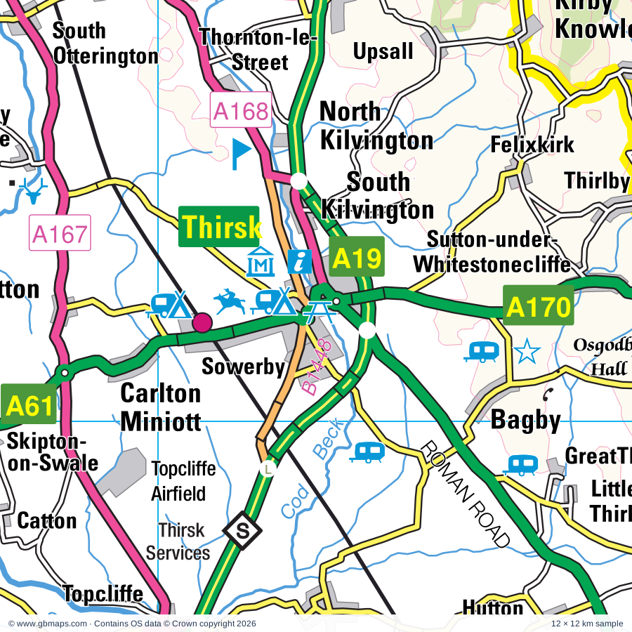
Thirsk & Easingwold regional road map. Full 60 × 60 km PDF, SVG and Illustrator files, with a free PDF sample.

GBMAPS.COM

Thirsk & Easingwold Regional Road Map

Call Us Now for Help01751 473136

GREAT BRITAIN ROAD ATLAS · 1:250,000 RY-01N

Thirsk & the Vale of York

Explore the full 60 × 60 km Thirsk & Easingwold regional road map at 1:250,000, covering Northallerton, Ripon, Knaresborough, Malton, Harrogate. Compare the complete coverage below; a detailed PDF sample is available free.

THIRSK & THE VALE OF YORKREGIONAL ROAD MAP
60 × 60 km · Full map previewDownload the free SVG ↓

INSIDE THE FULL 60 × 60 KM MAP

Explore the Thirsk & Easingwold map area

1:250,000 cartography

Towns, villages & places

More mapped places (275)
  • Coxwold
  • Thormanby
  • Husthwaite
  • Wass
  • Felixkirk
  • Scawton
  • Sessay
  • Boltby
  • Sowerby
  • Oulston
  • Old Byland
  • Dalton
  • Ampleforth
  • Upsall
  • Raskelf
  • Rievaulx
  • Fawdington
  • Yearsley
  • Knayton
  • Cowesby
  • Cundall
  • Topcliffe
  • Asenby
  • Crayke
  • Kepwick
  • Sproxton
  • Brafferton
  • Borrowby
  • Brandsby
  • Helperby
  • Sandhutton
  • Oswaldkirk
  • Carlton
  • Catton
  • Nether Silton
  • Tholthorpe
  • Dishforth
  • Rainton
  • Stearsby
  • Over Silton
  • Howe
  • Flawith
  • Coulton
  • Alne
  • Baldersby
  • Stillington
  • Cawton
  • Harome
  • Pockley
  • Sinderby
  • Skewsby
  • Huby
  • Tollerton
  • Pickhill
  • Stonegrave
  • Marton-le-Moor
  • Beadlam
  • Maunby
  • Thimbleby
  • Nawton
  • Whenby
  • Melmerby
  • Youlton
  • Langthorpe
  • Aldborough
  • Nunnington
  • Scackleton
  • Aldwark
  • Farlington
  • Hovingham
  • Wombleton
  • Osmotherley
  • Wath
  • Ellerbeck
  • Kirklington
  • Copt Hewick
  • Minskip
  • Grafton
  • Great Ouseburn
  • Roecliffe
  • Muscoates
  • Warlaby
  • Marton
  • Sharow
  • Gatenby
  • Bridge Hewick
  • Romanby
  • Terrington
  • Fryton
  • Carthorpe
  • Burneston
  • Little Ouseburn
  • Fadmoor
  • Theakston
  • Slingsby
  • Brompton
  • Chop Gate
  • Littlethorpe
  • Gillamoor
  • Thornborough
  • Great Edstone
  • Ganthorpe
  • Londonderry
  • Salton
  • Swainby
  • Exelby
  • Keldholme
  • Shipton
  • Cockayne
  • Arkendale
  • Staveley
  • Thrintoft
  • Nosterfield
  • Leeming
  • Beningbrough
  • Whorlton
  • Whixley
  • Coneysthorpe
  • Faceby
  • Urra
  • West Tanfield
  • Brawby
  • Scruton
  • Strensall
  • Butterwick
  • Ferrensby
  • Well
  • Coneythorpe
  • Marton
  • Leeming Bar
  • Bulmer
  • Normanby
  • Wigginton
  • Snape
  • Potto
  • Lovesome Hill
  • Church Houses
  • Mickley
  • Spaunton
  • Flaxby
  • Skelton
  • Welbury
  • Aiskew
  • Azerley
  • Great Barugh
  • Farnham
  • Flaxton
  • Foston
  • Deighton
  • Towthorpe
  • Sinnington
  • Little Habton
  • Lastingham
  • Little Fencote
  • Hutton Bonville
  • Earswick
  • Markington
  • Aldfield
  • Great Busby
  • Galphay
  • Amotherby
  • Brearton
  • Little Barugh
  • Kirkby Fleetham
  • Kirkby
  • Cattal
  • Winksley
  • Thorgill
  • Goldsborough
  • Hessay
  • Swinton
  • Streetlam
  • Huntington
  • New Earswick
  • Burrill
  • Scotton
  • Grewelthorpe
  • Wrelton
  • Harton
  • Cowling
  • Langthorne
  • Hunsingore
  • High Hutton
  • Cropton
  • Claxton
  • Crambe
  • Kirkham
  • Broughton
  • Tockwith
  • Sawley
  • Laverton
  • Crathorne
  • Risplith
  • Birkby
  • Nidd
  • Aislaby
  • Rufforth
  • Cowthorpe
  • Swinton
  • Middleton
  • High Grantley
  • Picton
  • Knapton
  • Stokesley
  • Thirn
  • Ripley
  • Hackforth
  • Hornby
  • Bossall
  • Howsham
  • Westow
  • Battersby
  • Ryton
  • Whitwell
  • Easby
  • Bickerton
  • Eavestone
  • Killinghall
  • Warthill
  • Scrayingham
  • Kirklevington
  • Westerdale
  • Hornby
  • Holtby
  • Sockburn
  • Murton
  • Clint
  • Kildale
  • Catterick
  • Girsby
  • Buttercrambe
  • Stape
  • Scorton
  • Hampsthwaite
  • Kennythorpe
  • Heslington
  • Dunnington
  • Leppington
  • Tunstall
  • Langton
  • Arrathorne
  • Follifoot
  • Burythorpe
  • Leavening
  • Birstwith
  • Skirpenbeck
  • Acklam
  • Castleton
  • Uckerby
  • Eryholme
  • Street
  • Pannal
  • Summerbridge
  • Ainthorpe
  • Kexby
  • Bugthorpe
  • Moulton
  • Danby
  • Staupes
  • Beckwithshaw
  • Darley
  • Kettlesing
  • Youlthorpe
  • Houlsyke
  • Wilberfoss
  • Skeeby
  • Glaisdale
  • Middleton Tyas
  • Fangfoss
  • Lealholm
  • Bolton
  • Newton Morrell
  • Barton
  • Yapham
  • Meltonby

Roads across this sheet

A1(M), A19, A59, A61, A67, A166, A167, A168, A169, A170, A171, A172, A173, A658, A661, A684, A1036, A1079, A1237, A6040, A6055, A6108, A6136, B1224

More road numbers

B1227, B1228, B1248, B1257, B1263, B1264, B1333, B1363, B1365, B1448, B6161, B6162, B6163, B6164, B6165, B6265, B6267, B6268, B6271, B6272, B6275, B6285, B6451

Rivers & waterways

Cod Beck, Costa Beck, Hodge Beck, Milby Cut, Ripon Canal, River Derwent, River Dove, River Esk, River Laver, River Leven, River Nidd, River Ouse

More waterways

River Riccal, River Rye, River Seph, River Seven, River Swale, River Tees, River Ure, River Washburn, River Wiske

Landmarks & landscape

Adventure Activity Centre, Aldborough Museum, Aldborough Roman Town (ISVRIVM), Allerton Park, Ampleforth Abbey, Amplethorpe College, Beck Isle Museum of Rural Life, Bedale Hall Museum, Bedern Hall, Fairfax House, Grand Assembly Rooms, Merchant Taylors' Hall, St Anthony's Hall, Mansion House, Beningbrough Hall, Birchwood Museum, Bird Attraction, Bird Gardens,Sanctuaries,Birds of, NORTH YORK MOORS NATIONAL PARK

More named features

Black Sheep Brewery Visitor Centre, Theakston Brewery Visitor Centre, Masham Art Gallery, Brimham Rocks, Burton Leonard Quarries, Byland Abbey, Byland Abbey (remains of), Castle Howard, Castle Howard Arboretum, Catterick Racecourse, Cawthorne Roman Camps, Centre for Early Music, The Psychic Museum, City of Troy (Turf Maze), Clifford's Tower, Courthouse Museum, Coxwold Pottery, Craft Centre, Croft Motor Racing Circuit, Cropton Brewery and Visitor Centre, Danelaw Dark Age Village, Derwent Valley Light Railway, Duncombe Park, Eden Camp, Falconry UK Birds of Prey Centre, Flamingo Land, Fountains Abbey, Fountains Hall, Gilling Castle, Great Yorkshire Showground, Hall, Harlow Carr Botanical Garden, Helmsley Castle, Helmsley Walled Garden, Hob Hole, ISVRIVM, Impressions Gallery, York City Art Gallery, Merchant Adventurers' Hall, York Brewery Tour, York Observatory, International Centre for Birds of Prey, Keldy Castle, Kilburn White Horse, Kilburn White Horse (Hill Figure), Killinghall Moor Country Park, Kiplin Hall, Kiplin Hall and Gardens, Kirkham Priory, Kirkham Priory (remains of), Knaresborough Castle, Lightwater Valley, Littlethorpe Potteries, Lord Stones Country Park, Marfield Nature Reserve, Markenfield Hall, Marmion Tower, Marton Abbey, Millennium Stone, Monk Park Farm Visitor Centre, Moorland Wood, Mount Grace Priory, Mouseman Visitor Centre, Newburgh Priory, Newby Hall, Newby Hall & Gardens, Nidd Gorge Nature Reserve, North Yorkshire Moors Railway, Norton Conyers, Nosterfield Nature Reserve, Nunnington Hall, Osgodby Hall, Pickering Castle, Plumpton Rocks, ROMAN CAMP, Ralph Crosses, Rawcliffe Bar Country Park, Regimental Museum, Richard 111 Museum, York Dungeon, York Story, Barley Hall, Rievaulx Abbey, Rievaulx Terrace and Temples, Ripley Castle, Ripley Castle and Gardens, Ripon Cathedral, Ripon Prison & Police Museum, Workhouse Museum, The Courthouse, Ripon Racecourse, Ryedale Folk Museum, Shandy Hall, Sheriff Hutton Castle, Sion Hill Hall, Snape Castle, Spofforth Castle, Spout House (The Original Sun Inn), St Mary's Church, St William's College, Studley Hall Water Garden, Studley Park, Studley Royal & Fountains Abbey (World Heritage Site), Sutton Bank National Park Centre, Sutton Park, The Big Sheep & Little Cow Farm, The Minster, The Moors National Park Centre, The Royal Pump Room, Quilt Museum and Gallery, Thirsk Museum, The World of James Herriot, Thirsk Racecourse, Thorpe Perrow Aboretum, Thorpe Prebend House, Treasurer's House, Valley Gardens, Visitor Centre, Wain Stones, Whitwell-on-the-Hill Point to Point Racecourse, York Castle, York Cold War Bunker, York Minster, St Mary's Abbey, York Minster, Treasurer's House, Yorkshire Lavender, Yorkshire Museum of Farming, Yorkshire Museum, National Railway Museum, Bar Convent Museum, Jorvick, Micklegate Bar Museum, The Arc
Local authority & parish coverage

Wholly or partly within the full map rectangle. These boundaries are coverage information, not additional artwork layers.

  • DarlingtonPartly within
  • East Riding of YorkshirePartly within
  • Leeds DistrictPartly within
  • North YorkshirePartly within
  • Stockton-on-TeesPartly within
  • YorkPartly within
Wards & electoral divisions 74 areas
  • Acomb Ward
  • Clifton Ward
  • Dringhouses & Woodthorpe Ward (part)
  • Eaglescliffe West Ward (part)
  • Fishergate Ward (part)
  • Fulford & Heslington Ward (part)
  • Guildhall Ward
  • Haxby & Wigginton Ward
  • Heworth Ward
  • Heworth Without Ward
  • Holgate Ward
  • Hull Road Ward (part)
  • Huntington & New Earswick Ward
  • Hurworth Ward (part)
  • Micklegate Ward (part)
  • Osbaldwick & Derwent Ward (part)
  • Pocklington Provincial Ward (part)
  • Rawcliffe & Clifton Without Ward
  • Rural West York Ward (part)
  • Southern Villages Ward (part)
  • Strensall Ward
  • Westfield Ward (part)
  • Wetherby Ward (part)
  • Wolds Weighton Ward (part)
  • Aiskew & Leeming ED
  • Amotherby & Ampleforth ED (part)
  • Bedale ED (part)
  • Bilton & Nidd Gorge ED
  • Bilton Grange & New Park ED
  • Boroughbridge & Claro ED
  • Catterick Village & Brompton-on-Swale ED (part)
  • Coppice Valley & Duchy ED
  • Danby & Mulgrave ED (part)
  • Easingwold ED
  • Esk Valley & Coast ED (part)
  • Fairfax & Starbeck ED
  • Great Ayton ED (part)
  • Harlow & St Georges ED
  • Helmsley & Sinnington ED
  • High Harrogate & Kingsley ED
  • Hillside & Raskelf ED
  • Hipswell & Colburn ED (part)
  • Huby & Tollerton ED
  • Hutton Rudby & Osmotherley ED (part)
  • Killinghall, Hampsthwaite & Saltergate ED
  • Kirkbymoorside & Dales ED (part)
  • Knaresborough East ED
  • Knaresborough West ED
  • Leyburn & Middleham ED (part)
  • Malton ED (part)
  • Masham & Fountains ED (part)
  • Morton-on-Swale & Appleton Wiske ED (part)
  • North Richmondshire ED (part)
  • Northallerton North & Brompton ED
  • Northallerton South ED
  • Norton ED (part)
  • Oatlands & Pannal ED
  • Ouseburn ED (part)
  • Pateley Bridge & Nidderdale ED (part)
  • Pickering ED (part)
  • Ripon Minster & Moorside ED
  • Ripon Ure Bank & Spa ED
  • Romanby ED
  • Scotton & Lower Wensleydale ED (part)
  • Sheriff Hutton & Derwent ED (part)
  • Sowerby & Topcliffe ED
  • Spofforth with Lower Wharfedale & Tockwith ED (part)
  • Stokesley ED (part)
  • Stray, Woodlands & Hookstone ED
  • Thirsk ED
  • Thornton Dale & Wolds ED (part)
  • Valley Gardens & Central Harrogate ED
  • Washburn & Birstwith ED (part)
  • Wathvale & Bishop Monkton ED
Civil parishes & communities 466 areas
  • Acklam CP (part)
  • Ainderby Miers with Holtby CP
  • Ainderby Quernhow CP
  • Ainderby Steeple CP
  • Aiskew and Leeming Bar CP
  • Aislaby CP
  • Akebar CP (part)
  • Aldbrough CP (part)
  • Aldfield CP
  • Aldwark CP
  • Allerton Mauleverer with Hopperton CP
  • Alne CP
  • Amotherby CP
  • Ampleforth CP
  • Angram Grange CP
  • Appleton East and West CP
  • Appleton Wiske CP
  • Appleton-le-Moors CP
  • Appleton-le-Street with Easthorpe CP
  • Arkendale CP
  • Arrathorne CP (part)
  • Asenby CP
  • Askham Bryan CP (part)
  • Azerley CP
  • Bagby CP
  • Baldersby CP
  • Balk CP
  • Barmby Moor CP (part)
  • Barton CP (part)
  • Barton-le-Street CP
  • Barton-le-Willows CP
  • Barugh (Great and Little) CP
  • Beadlam CP
  • Beckwithshaw CP
  • Bedale CP
  • Beningbrough CP
  • Bilsdale Midcable CP
  • Bilton-in-Ainsty with Bickerton CP (part)
  • Birdforth CP
  • Birdsall CP (part)
  • Birkby CP
  • Birstwith CP
  • Bishop Monkton CP
  • Bishop Thornton, Shaw Mills and Warsill CP
  • Bishop Wilton CP (part)
  • Boltby CP
  • Bolton-on-Swale CP
  • Boroughbridge CP
  • Borrowby CP
  • Brafferton and Helperby CP
  • Brandsby-cum-Stearsby CP
  • Bransdale CP
  • Brawby CP
  • Brearton CP
  • Bridge Hewick CP
  • Brompton CP
  • Brompton-on-Swale CP
  • Brough with St. Giles CP
  • Broughton CP
  • Bugthorpe CP
  • Bulmer CP
  • Burneston CP
  • Burrill with Cowling CP
  • Burton Leonard CP
  • Burton-on-Yore CP
  • Burythorpe CP (part)
  • Buttercrambe with Bossall CP
  • Byland with Wass CP
  • Carlton CP
  • Carlton Husthwaite CP
  • Carlton Miniott CP
  • Carthorpe CP
  • Castlelevington CP (part)
  • Cattal CP
  • Catterick CP
  • Catton CP
  • Catton CP
  • Cawton CP
  • Claxton CP
  • Cleasby CP (part)
  • Clifton Without CP
  • Clifton-on-Yore CP
  • Clint cum Hamlets CP
  • Colburn CP (part)
  • Cold Kirby CP
  • Commondale CP (part)
  • Coneysthorpe CP
  • Coneythorpe and Clareton CP
  • Copgrove CP
  • Copt Hewick CP
  • Cotcliffe CP
  • Coulton CP
  • Cowesby CP
  • Coxwold CP
  • Crakehall CP
  • Crambe CP
  • Crathorne CP
  • Crayke CP
  • Croft-on-Tees CP (part)
  • Cropton CP
  • Crosby CP
  • Cundall with Leckby CP
  • Dacre CP (part)
  • Dalby-cum-Skewsby CP
  • Dalton CP
  • Dalton-on-Tees CP
  • Danby CP (part)
  • Danby Wiske with Lazenby CP
  • Darley and Menwith CP (part)
  • Deighton CP
  • Dishforth CP
  • Dunnington CP (part)
  • Dunsforths CP
  • Earswick CP
  • Easby CP (part)
  • Easby CP (part)
  • Easingwold CP
  • East Cowton CP
  • East Harlsey CP
  • East Rounton CP
  • East Tanfield CP
  • East Witton CP (part)
  • Eavestone CP (part)
  • Edstone CP
  • Egton CP (part)
  • Eldmire with Crakehill CP
  • Ellenthorpe CP
  • Ellerbeck CP
  • Ellerton-on-Swale CP
  • Ellington High and Low CP (part)
  • Eryholme CP (part)
  • Exelby, Leeming and Londonderry CP
  • Faceby CP
  • Fadmoor CP
  • Fangfoss CP
  • Farlington CP
  • Farndale East CP
  • Farndale West CP
  • Farnham CP
  • Farnley CP (part)
  • Fawdington CP
  • Fearby CP (part)
  • Felixkirk CP
  • Felliscliffe CP
  • Ferrensby CP
  • Fewston CP (part)
  • Firby CP
  • Flawith CP
  • Flaxby CP
  • Flaxton CP
  • Follifoot CP
  • Foston CP
  • Fryton CP
  • Full Sutton CP
  • Gate Helmsley CP
  • Gatenby CP
  • Gillamoor CP
  • Gilling East CP
  • Gilling with Hartforth and Sedbury CP (part)
  • Girsby CP
  • Givendale CP
  • Glaisdale CP (part)
  • Goldsborough CP
  • Grantley CP
  • Great Ayton CP (part)
  • Great Busby CP
  • Great Langton CP
  • Great Ouseburn CP
  • Great Ribston with Walshford CP
  • Great Smeaton CP
  • Great and Little Broughton CP
  • Green Hammerton CP
  • Grewelthorpe CP (part)
  • Grimstone CP
  • Habton CP (part)
  • Hackforth CP
  • Hampsthwaite CP
  • Harome CP
  • Harrogate CP
  • Hartoft CP
  • Harton CP
  • Hartwith cum Winsley CP (part)
  • Haverah Park CP
  • Hawnby CP
  • Haxby CP
  • Helmsley CP
  • Henderskelfe CP
  • Heslington CP (part)
  • Hessay CP
  • Heworth Without CP
  • High Worsall CP (part)
  • High and Low Bishopside CP (part)
  • Holme CP
  • Holtby CP
  • Hood Grange CP
  • Hornby CP
  • Hornby CP
  • Hovingham CP
  • Howe CP
  • Howgrave CP
  • Howsham CP
  • Huby CP
  • Humberton CP
  • Hunsingore CP
  • Huntington CP
  • Hunton CP (part)
  • Hurworth CP (part)
  • Husthwaite CP
  • Hutton Bonville CP
  • Hutton Conyers CP
  • Hutton Mulgrave CP (part)
  • Hutton Rudby CP
  • Hutton-Sessay CP
  • Hutton-le-Hole CP
  • Huttons Ambo CP
  • Ilton-cum-Pott CP (part)
  • Ingleby Arncliffe CP
  • Ingleby Greenhow CP
  • Kepwick CP
  • Kexby CP (part)
  • Kilburn High and Low CP
  • Kildale CP (part)
  • Killerby CP
  • Killinghall CP
  • Kiplin CP
  • Kirby Hall CP
  • Kirby Hill CP
  • Kirby Knowle CP
  • Kirby Misperton CP
  • Kirby Sigston CP
  • Kirby Underdale CP (part)
  • Kirby Wiske CP
  • Kirk Deighton CP (part)
  • Kirk Hammerton CP
  • Kirkby CP
  • Kirkby Fleetham with Fencote CP
  • Kirkby Malzeard CP (part)
  • Kirkby Overblow CP (part)
  • Kirkbymoorside CP
  • Kirklevington CP (part)
  • Kirklington-cum-Upsland CP
  • Knaresborough CP
  • Knayton with Brawith CP
  • Landmoth-cum-Catto CP
  • Langthorne CP
  • Langthorpe CP
  • Langton CP (part)
  • Lastingham CP
  • Laverton CP (part)
  • Leake CP
  • Leavening CP (part)
  • Lillings Ambo CP
  • Lindley CP (part)
  • Lindrick with Studley Royal and Fountains CP
  • Linton-on-Ouse CP
  • Little Ayton CP (part)
  • Little Busby CP
  • Little Langton CP
  • Little Ouseburn CP
  • Little Ribston CP
  • Little Smeaton CP
  • Littlethorpe CP
  • Long Marston CP (part)
  • Low Worsall CP (part)
  • Malton CP (part)
  • Marishes CP (part)
  • Markenfield Hall CP
  • Markington with Wallerthwaite CP
  • Marton CP
  • Marton cum Grafton CP
  • Marton-cum-Moxby CP
  • Marton-le-Moor CP
  • Masham CP
  • Maunby CP
  • Melmerby CP
  • Melsonby CP (part)
  • Middleton CP
  • Middleton Quernhow CP
  • Middleton Tyas CP (part)
  • Middleton-on-Leven CP (part)
  • Milby CP
  • Moor Monkton CP
  • Morton-on-Swale CP
  • Moulton CP
  • Murton CP
  • Myton-on-Swale CP
  • Nawton CP
  • Neasham CP (part)
  • Nether Poppleton CP
  • Nether Silton CP
  • New Earswick CP
  • Newall with Clifton CP (part)
  • Newburgh CP
  • Newby Wiske CP
  • Newby with Mulwith CP
  • Newsham CP (part)
  • Newsham with Breckenbrough CP
  • Newton CP (part)
  • Newton Morrell CP (part)
  • Newton on Derwent CP (part)
  • Newton-le-Willows CP (part)
  • Newton-on-Ouse CP
  • Nidd CP
  • Normanby CP
  • North Cowton CP
  • North Deighton CP
  • North Kilvington CP
  • North Otterington CP
  • North Rigton CP (part)
  • North Stainley with Sleningford CP
  • Northallerton CP
  • Norton Conyers CP
  • Norton-le-Clay CP
  • Norton-on-Derwent CP (part)
  • Norwood CP (part)
  • Nun Monkton CP
  • Nunnington CP
  • Old Byland and Scawton CP
  • Oldstead CP
  • Osbaldwick CP
  • Osmotherley CP
  • Oswaldkirk CP
  • Oulston CP
  • Over Dinsdale CP (part)
  • Over Silton CP
  • Overton CP
  • Pannal and Burn Bridge CP
  • Patrick Brompton CP
  • Pickering CP (part)
  • Pickhill with Roxby CP
  • Picton CP
  • Plompton CP
  • Pockley CP
  • Pocklington CP (part)
  • Potto CP
  • Rainton with Newby CP
  • Rand Grange CP
  • Raskelf CP
  • Rawcliffe CP
  • Rievaulx CP
  • Ripley CP
  • Ripon CP
  • Roecliffe CP
  • Romanby CP
  • Rookwith CP (part)
  • Rosedale East Side CP
  • Rosedale West Side CP
  • Rudby CP
  • Rufforth with Knapton CP (part)
  • Salton CP
  • Sand Hutton CP
  • Sandhutton CP
  • Sawley CP
  • Scackleton CP
  • Scorton CP
  • Scotton CP
  • Scrayingham CP
  • Scriven CP
  • Scruton CP
  • Seamer CP (part)
  • Sessay CP
  • Sexhow CP
  • Sharow CP
  • Sheriff Hutton CP
  • Shipton CP
  • Sinderby CP
  • Sinnington CP
  • Skeeby CP (part)
  • Skelding CP (part)
  • Skelton CP
  • Skelton-on-Ure CP
  • Skipton-on-Swale CP
  • Skirpenbeck CP
  • Skutterskelfe CP
  • Slingsby CP
  • Snape with Thorp CP
  • South Cowton CP
  • South Holme CP
  • South Kilvington CP
  • South Otterington CP
  • South Stainley with Cayton CP
  • Sowerby CP
  • Sowerby-under-Cotcliffe CP
  • Spaunton CP
  • Spofforth with Stockeld CP (part)
  • Sproxton CP
  • Stainburn CP (part)
  • Stamford Bridge CP
  • Stape CP (part)
  • Stapleton CP (part)
  • Staveley CP
  • Stillington CP
  • Stockton-on-the-Forest CP
  • Stokesley CP (part)
  • Stonegrave CP
  • Strensall with Towthorpe CP
  • Studley Roger CP
  • Sutton with Howgrave CP
  • Sutton-on-the-Forest CP
  • Sutton-under-Whitestonecliffe CP
  • Swainby with Allerthorpe CP
  • Swinton CP
  • Swinton with Warthermarske CP (part)
  • Terrington CP
  • Theakston CP
  • Thimbleby CP
  • Thirkleby High and Low with Osgodby CP
  • Thirlby CP
  • Thirn CP
  • Thirsk CP
  • Thixendale CP (part)
  • Tholthorpe CP
  • Thormanby CP
  • Thornbrough CP
  • Thornton Bridge CP
  • Thornton Watlass CP
  • Thornton-le-Beans CP
  • Thornton-le-Clay CP
  • Thornton-le-Moor CP
  • Thornton-le-Street CP
  • Thornton-on-the-Hill CP
  • Thornville CP
  • Thorpe Underwoods CP
  • Thrintoft CP
  • Tockwith CP
  • Tollerton CP
  • Topcliffe CP
  • Tunstall CP (part)
  • Uckerby CP
  • Ugthorpe CP (part)
  • Upper Helmsley CP
  • Upper Poppleton CP
  • Upsall CP
  • Walkingham Hill with Occaney CP
  • Warlaby CP
  • Warsill CP
  • Warthill CP
  • Wath CP
  • Welburn CP
  • Welburn CP
  • Welbury CP
  • Well CP
  • West Harlsey CP
  • West Rounton CP
  • West Tanfield CP
  • Westerdale CP
  • Westow CP
  • Westwick CP
  • Wetherby CP (part)
  • Whenby CP
  • Whitwell CP
  • Whitwell-on-the-Hill CP
  • Whixley CP
  • Whorlton CP
  • Wigginton CP
  • Wilberfoss CP
  • Wildon Grange CP
  • Wilstrop CP
  • Winksley CP
  • Winton, Stank and Hallikeld CP
  • Wombleton CP
  • Wrelton CP
  • Yafforth CP
  • Yapham CP (part)
  • Yearsley CP
  • Youlton CP

Source: the GBMaps road atlas, OS Boundary-Line and postcode mapping datasets. Source editions are being checked for publication. Unmarked boundary names are wholly within the sheet; “part” means the map edge crosses the area.

Place lists are selected from the map source, not a complete gazetteer. Named features describe the cartography; visitor facilities and opening status are not verified. The free sample covers only 12 × 12 km of this larger sheet.

INSIDE YOUR DOWNLOAD

A proper road map, in useful formats

Road classifications, towns and villages, railways, rivers, landscape detail and tourist symbols, brought together in the GBMaps regional road atlas style.

PDF filePDFSVG fileSVGAdobe Illustrator AI fileAi

PDF for the finished map. SVG and layered Illustrator artwork for adapting colours, adding your own information and preparing designs.

THE FINISHED SHEET

Designed for print and presentation

Map coverage
60 × 60 km
Sample coverage
12 × 12 km
Print layout
A3 landscape · enlarged 1:250k cartography
Sheet furniture
Border, scale bar, key & north arrow

A few useful details

What changes when I select another square?

Select a surrounding square to bring it into the centre and reveal the maps around it. Each square is a different 60 × 60 km map. The preview, free sample and selected download change together. Neighbouring sheets overlap by 30 km so you can choose the coverage that suits you.

Is the free sample a vector map?

The on-page detail is an SVG. The free download is a separate 12 × 12 km PDF with a link to the full map. Please retain its copyright credits and product link when sharing it.

Can I buy a larger combined map?

These downloads are individual ready-made sheets. Contact GBMaps if you need a larger combined area.

FREE PDF SAMPLE

Your free map sample

Your free 12 × 12 km sample includes a link back to this map, so you can return for the full area whenever you need it.

Download free PDF sample ↓

Get your Thirsk & Easingwold map

Map download bundle

£24.00including VATOne payment

Pay securely

One payment. Your map stays open.

Your map download

Your map files

Preparing your download…

Checking your private download link…

Your map downloads

Already bought a map?

Find the downloads from your purchases.

Enter the email address you used at checkout. We’ll email you a private link to your available map downloads.