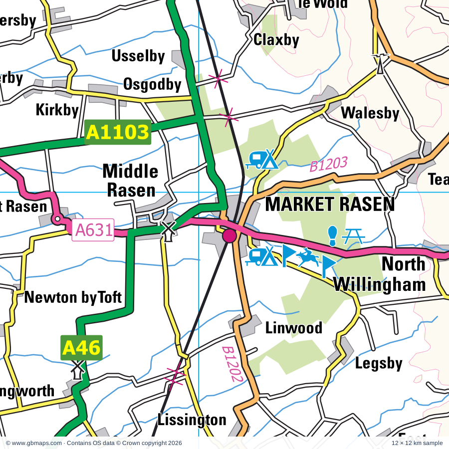
Market Rasen regional road map. Full 60 × 60 km PDF, SVG and Illustrator files, with a free PDF sample.

GBMAPS.COM

Market Rasen Regional Road Map

Call Us Now for Help01751 473136

GREAT BRITAIN ROAD ATLAS · 1:250,000 RY-51

Market Rasen & surrounding area

Explore the full 60 × 60 km Market Rasen regional road map at 1:250,000, covering Market Rasen, Brigg, Lincoln, Louth, Horncastle. Compare the complete coverage below; a detailed PDF sample is available free.

MARKET RASEN & SURROUNDING AREAREGIONAL ROAD MAP
60 × 60 km · Full map previewDownload the free SVG ↓

INSIDE THE FULL 60 × 60 KM MAP

Explore the Market Rasen map area

1:250,000 cartography

Towns, villages & places

More mapped places (283)
  • Newton by Toft
  • Toft next Newton
  • North Owersby
  • Faldingworth
  • Newtoft
  • Lissington
  • Bishopbridge
  • Friesthorpe
  • Sixhills
  • Thornton le Moor
  • Holton le Moor
  • Wickenby
  • Cold Hanworth
  • Snarford
  • Thoresway
  • Moortown
  • Hainton
  • Snelland
  • Glentham
  • Ludford
  • Nettleton
  • Spridlington
  • Rothwell
  • Brandy Wharf
  • Fulnetby
  • West Barkwith
  • Rand
  • Brookenby
  • Caistor
  • Binbrook
  • Bishop Norton
  • Croxby
  • Atterby
  • Snitterby
  • Cabourne
  • Hackthorn
  • North Kelsey
  • Panton
  • Dunholme
  • Cuxwold
  • Thorganby
  • Waddingham
  • Benniworth
  • Swinhope
  • Welton
  • Langworth
  • Scothern
  • Grasby
  • Apley
  • Swallow
  • Howsham
  • Kingthorpe
  • Kelstern
  • Sudbrooke
  • Hatton
  • Glentworth
  • Sotby
  • Hatcliffe
  • Cadney
  • Fillingham
  • Beelsby
  • Searby
  • Redbourne
  • Harpswell
  • Ingham
  • Stainfield
  • Hemswell
  • Cammeringham
  • Blyborough
  • Nettleham
  • Willoughton
  • Reepham
  • Ranby
  • Hibaldstow
  • Great Sturton
  • Grayingham
  • Brattleby
  • Stenigot
  • Bigby
  • Minting
  • Aisthorpe
  • Scampton
  • Fiskerton
  • Goulceby
  • Gautby
  • Withcall
  • Brigsley
  • Riby
  • North Carlton
  • Asterby
  • Baumber
  • South Carlton
  • Laceby
  • Grainsby
  • Ludborough
  • Scawby
  • Aylesby
  • Wrawby
  • Bardney
  • Hemingby
  • Thorpe le Fallows
  • Hallington
  • Cawkwell
  • Manton
  • Keelby
  • Washingborough
  • Utterby
  • Scamblesby
  • Branston Booths
  • Kirmington
  • Waltham
  • Raithby
  • Dovendale
  • Wispington
  • Fotherby
  • Heighington
  • Northorpe
  • Brocklesby
  • Bradley
  • Maltby
  • Bucknall
  • Heapham
  • Croxton
  • Springthorpe
  • Broxholme
  • Edlington
  • Scotton
  • Bransby
  • Aisby
  • Corringham
  • Stow
  • Tathwell
  • Willingham by Stow
  • Broughton
  • Kexby
  • Elsham
  • Canwick
  • Upton
  • Horsington
  • Wressle
  • Southrey
  • New Waltham
  • Stallingborough
  • Branston
  • Scotter
  • Healing
  • Pilham
  • Tetney
  • Belchford
  • Potterhanworth
  • Habrough
  • Fulstow
  • West Ashby
  • Thimbleby
  • Oxcombe
  • Farforth
  • Ulceby
  • Blyton
  • Keddington
  • Langton
  • Yarburgh
  • Messingham
  • Stixwould
  • Worlaby
  • Skellingthorpe
  • Haugham
  • Saxilby
  • Scotterthorpe
  • Sots Hole
  • Fulletby
  • Nocton
  • Low Toynton
  • Wootton
  • Broadholme
  • Humberston
  • Ruckland
  • Alvingham
  • Stewton
  • Laughton
  • Thornton
  • Tetney Lock
  • Bonby
  • Legbourne
  • Gate Burton
  • North Cotes
  • High Toynton
  • Dunston
  • Lea
  • Burnham
  • Brampton
  • Marton
  • Knaith
  • Marshchapel
  • Santon
  • Torksey
  • Burwell
  • Tetford
  • Salmonby
  • Eskham
  • Doddington
  • Dalderby
  • Greetham
  • Littleborough
  • Fenton
  • Muckton
  • Metheringham
  • Roughton
  • Kettlethorpe
  • Appleby
  • Susworth
  • Harby
  • Grimoldby
  • Grainthorpe
  • Thorney
  • Laughterton
  • Manby
  • Martin
  • Cottam
  • Somersby
  • Blankney
  • Low Risby
  • Ludney
  • Haltham
  • Wildsworth
  • High Risby
  • Horkstow
  • Harmston
  • White Pit
  • Eagle Moor
  • Bag Enderby
  • Owston Ferry
  • Hameringham
  • Wigsley
  • Swaby
  • Brinkhill
  • Hagworthingham
  • Coleby
  • Eagle
  • Belleau
  • Laneham
  • Harrington
  • Moorby
  • Roxby
  • Lusby
  • Haddington
  • Burringham
  • Driby
  • Derrythorpe
  • Aubourn
  • North Clifton
  • Althorpe
  • Asgarby
  • Gunness
  • Sunk Island
  • Beltoft
  • Spalford
  • Keadby
  • Miningsby
  • Flixborough
  • Hareby
  • Aswardby
  • South Clifton
  • Ragnall
  • Normanby
  • Thurlby
  • Amcotts
  • Thealby
  • Revesby
  • Sausthorpe
  • Langton
  • Swinderby
  • Coleby
  • East Kirkby
  • Girton
  • Besthorpe
  • West Keal
  • Luddington
  • Garthorpe
  • Fockerby
  • Collingham
  • Eastoft
  • Skeffling
  • Easington

Roads across this sheet

M180, M181, A15, A16, A18, A46, A57, A153, A155, A156, A157, A158, A159, A160, A161, A180, A607, A631, A1029, A1031, A1077, A1084, A1098, A1103

More road numbers

A1133, A1136, A1173, A1243, A1434, A1500, B1003, B1131, B1178, B1182, B1183, B1188, B1189, B1190, B1191, B1192, B1195, B1200, B1201, B1202, B1203, B1204, B1205, B1206, B1207, B1208, B1210, B1211, B1212, B1213, B1216, B1218, B1219, B1225, B1226, B1241, B1262, B1273, B1308, B1360, B1374, B1378, B1392, B1398, B1399, B1400, B1430, B1433, B1434, B1444, B1445, B1450, B1501, B1520

Rivers & waterways

CAR DYKE, Dales Head Dike, Fossdyke Navigation, Fossdyke Navigation Canal, Great Eau, Hobhole Drain, Land Drain, Louth Canal, New River Ancholme, North Kelsey Beck, Old River Ancholme, River Ancholme

More waterways

River Bain, River Brant, River Eau, River Freshney, River Till, River Torne, River Trent, River Witham, Stainforth & Keadby Canal, Steeping River, Timberland Delph

Landmarks & landscape

Bardney Abbey, Bardney Abbey (remains of), Bardney Heritage Centre, Barlings Abbey, Barlings Abbey (remains of), Barnovallum Gardens, Bolingbroke Castle, Bradley Woods Nature Reserve, Brandy Wharf Cider Centre, Bransby Home of Rest for Horses, Branston Solar Farm, Brumby Common

More named features

Bull Sand Fort, Cadwell Park, Caistor Arts and Heritage Centre, Chamber's Farm Wood Nature Reserve, Chamber's Farm Wood Visitor Centre, Chamber's Butterfly Garden, Cleethorpes Coast Light Railway, Cleethorpes Country Park, Covenham Reservoir Nature Reserve, Craft Centre, Doddington Hall, Doddington Hall and Garden, Ellis' Windmill, Elsham Hall Country Park, Freshney Parkway Nature Reserve, Gainsborough Old Hall, Gainsthorpe Medieval Village, Great Northern Railway, Haile Sand Fort, Hall Park Farm, Hartsholme Country Park, Hemswell Craft and Design Centre, Hewitt's Windmill, Humber Estuary Discovery Centre, Immingham Museum, Johnstones Farm Centre, Kirton Pottery, Legbourne Railway Museum, Lincoln Bishop's Old Palace, Lincoln Castle, Lincoln Cathedral, Lincolnshire Agricultural Showground, Lincolnshire Aviation Heritage Museum, Lincolnshire Road Transport Museum, Louth Museum, Normanby Park Farming Museum, Manby Showground, Market Rasen Racecourse, Meditation Centre and Japanese Garden, Motor Racing Circuit, Mount Pleasant Mill, Museum of Lincolnshire Life, New Lincoln City Museum, Museum of Rural Life, National Fishing Heritage Centre, Normanby Hall, Normanby Hall Country Park, Normanby Park Fishing Museum, National Fishing Heritage Centre, Normanby Hall, North Lincs Museum, Owston Ferry The Old Smithy and Heritage Centre, Peasam Hill Nature Reserve, Pleasure Island Theme Park, RAF Wickenby Museum, Rand Farm Park, Red Hill Nature Reserve, Rushmoor Country Park Rare Breed Poultry, Snipe Dales Country Park, Spalford Warren Nature Reserve, St Mary's Church, Stockwith Mill, Swanholme Lakes Nature Reserve, The Jungle, The Pine Woods Nature Reserve, The Pink Pig, Thornton Abbey, Time Warp Discovery Centre, Newby Centre, Tupholme Abbey, Tupholme Abbey (remains of), Waddington Aircraft Viewing Enclosure, Waltham Windmill, Whisby Nature Park, Visitor Centre, Woodhall Spa Cottage Museum
Local authority & parish coverage

Wholly or partly within the full map rectangle. These boundaries are coverage information, not additional artwork layers.

  • Bassetlaw DistrictPartly within
  • East Lindsey DistrictPartly within
  • East Riding of YorkshirePartly within
  • Lincoln DistrictWholly within
  • Newark and Sherwood DistrictPartly within
  • North East LincolnshireWholly within
  • North Kesteven DistrictPartly within
  • North LincolnshirePartly within
  • West Lindsey DistrictPartly within
Wards & electoral divisions 113 areas
  • Abbey Ward
  • Ashby Central Ward
  • Ashby Lakeside Ward
  • Axholme Central Ward (part)
  • Axholme North Ward (part)
  • Axholme South Ward (part)
  • Bardney Ward
  • Barton Ward (part)
  • Bassingham Rural Ward (part)
  • Beckingham Ward (part)
  • Billinghay Rural Ward (part)
  • Binbrook Ward
  • Birchwood Ward
  • Bottesford Ward
  • Boultham Ward
  • Bracebridge Heath Ward
  • Branston Ward
  • Brigg & Wolds Ward (part)
  • Broughton & Scawby Ward
  • Brumby Ward
  • Burringham & Gunness Ward
  • Burton upon Stather & Winterton Ward (part)
  • Caistor and Yarborough Ward
  • Carholme Ward
  • Castle Ward
  • Cherry Willingham Ward
  • Collingham Ward (part)
  • Coningsby & Mareham Ward (part)
  • Croft Baker Ward
  • Crosby & Park Ward
  • Dunholme and Welton Ward
  • East Marsh Ward
  • Ferry Ward (part)
  • Freshney Ward
  • Friskney Ward (part)
  • Frodingham Ward
  • Fulstow Ward
  • Gainsborough East Ward
  • Gainsborough North Ward
  • Gainsborough South-West Ward
  • Glebe Ward
  • Grimoldby Ward (part)
  • Hagworthingham Ward (part)
  • Halton Holegate Ward (part)
  • Hartsholme Ward
  • Haverstoe Ward
  • Heighington & Washingborough Ward
  • Hemswell Ward
  • Heneage Ward
  • Holton-le-Clay & North Thoresby Ward
  • Horncastle Ward
  • Humberston and New Waltham Ward
  • Hykeham Central Ward
  • Hykeham Fosse Ward
  • Hykeham Memorial Ward
  • Immingham Ward
  • Kelsey Wold Ward
  • Kingsway with Lincoln Gardens Ward
  • Lea Ward
  • Legbourne Ward (part)
  • Market Rasen Ward
  • Marshchapel & Somercotes Ward (part)
  • Messingham Ward
  • Metheringham Rural Ward (part)
  • Minster Ward
  • Moorland Ward
  • Muskham Ward (part)
  • Navenby & Brant Broughton Ward (part)
  • Nettleham Ward
  • North Holme Ward
  • Park Ward
  • Park Ward
  • Priory & St. James' Ward
  • Rampton Ward (part)
  • Ridge Ward
  • Roughton Ward
  • Saxilby Ward
  • Scampton Ward
  • Scartho Ward
  • Scotter and Blyton Ward (part)
  • Sibsey & Stickney Ward (part)
  • Sidney Sussex Ward
  • Skellingthorpe & Eagle Ward
  • Snaith, Airmyn, Rawcliffe and Marshland Ward (part)
  • South East Holderness Ward (part)
  • South Ward
  • South West Holderness Ward (part)
  • Spilsby Ward (part)
  • St. Margaret's Ward
  • St. Mary's Ward
  • St. Michael's Ward
  • Stow Ward
  • Sturton Ward (part)
  • Sudbrooke Ward
  • Sutton-on-Trent Ward (part)
  • Tetford & Donington Ward
  • Tetney Ward
  • Torksey Ward
  • Town Ward
  • Trinity Ward
  • Tuxford and Trent Ward (part)
  • Waddingham and Spital Ward
  • Waddington Rural Ward (part)
  • Waltham Ward
  • West Marsh Ward
  • Witham St. Hughs & Swinderby Ward
  • Witham Ward
  • Withern & Theddlethorpe Ward (part)
  • Wold View Ward
  • Wolds Ward
  • Woodhall Spa Ward (part)
  • Wragby Ward
  • Yarborough Ward
Civil parishes & communities 398 areas
  • Aisthorpe CP
  • Alkborough CP (part)
  • Alvingham CP
  • Amcotts CP
  • Apley CP
  • Appleby CP
  • Ashby Parkland CP
  • Ashby cum Fenby CP
  • Asterby CP
  • Aswardby CP
  • Aubourn with Haddington CP
  • Authorpe CP (part)
  • Aylesby CP
  • Bardney CP
  • Barlings CP
  • Barnetby Le Wold CP
  • Barnoldby Le Beck CP
  • Barrow upon Humber CP (part)
  • Barton CP (part)
  • Bassingham CP (part)
  • Baumber CP
  • Beckingham CP (part)
  • Beelsby CP
  • Belchford CP
  • Belleau CP (part)
  • Belton CP (part)
  • Benniworth CP
  • Besthorpe CP
  • Bigby CP
  • Binbrook CP
  • Bishop Norton CP
  • Blankney CP (part)
  • Blyborough CP
  • Blyton CP (part)
  • Bole CP (part)
  • Bolingbroke CP
  • Bonby CP
  • Boothby Graffoe CP (part)
  • Bottesford CP
  • Bracebridge Heath CP
  • Brackenborough with Little Grimsby CP
  • Bradley CP
  • Brampton CP
  • Branston and Mere CP
  • Brattleby CP
  • Brigg CP
  • Brigsley CP
  • Brinkhill CP
  • Broadholme CP
  • Brocklesby CP
  • Brookenby CP
  • Broughton CP
  • Broxholme CP
  • Bucknall CP
  • Bullington CP
  • Burgh on Bain CP
  • Burringham CP
  • Burton CP
  • Burton upon Stather CP
  • Burwell CP
  • Buslingthorpe CP
  • Cabourne CP
  • Cadney CP
  • Caenby CP
  • Caistor CP
  • Calcethorpe with Kelstern CP
  • Cammeringham CP
  • Canwick CP
  • Carlton-on-Trent CP (part)
  • Cherry Willingham CP
  • Claxby CP
  • Claxby with Moorby CP
  • Claythorpe CP (part)
  • Cold Hanworth CP
  • Coleby CP (part)
  • Collingham CP (part)
  • Conisholme CP (part)
  • Corringham CP
  • Cottam CP
  • Covenham St. Bartholomew CP
  • Covenham St. Mary CP
  • Cromwell CP (part)
  • Crowle and Ealand CP (part)
  • Croxton CP
  • Doddington and Whisby CP
  • Donington on Bain CP
  • Dunham-on-Trent CP (part)
  • Dunholme CP
  • Dunston CP
  • Eagle and Swinethorpe CP
  • Easington CP (part)
  • East Barkwith CP
  • East Butterwick CP
  • East Ferry CP
  • East Halton CP (part)
  • East Keal CP
  • East Kirkby CP (part)
  • East Ravendale CP
  • East Stockwith CP (part)
  • Eastoft CP (part)
  • Edlington with Wispington CP
  • Elkington CP
  • Elsham CP
  • Epworth CP (part)
  • Faldingworth CP
  • Fenton CP
  • Fillingham CP
  • Fiskerton CP
  • Fledborough CP (part)
  • Flixborough CP
  • Fotherby CP
  • Friesthorpe CP
  • Fulletby CP
  • Fulnetby CP
  • Fulstow CP
  • Gainsborough CP
  • Garthorpe and Fockerby CP (part)
  • Gate Burton CP
  • Gautby CP
  • Gayton Le Wold CP
  • Girton CP
  • Glentham CP
  • Glentworth CP
  • Goltho CP
  • Goulceby CP
  • Goxhill CP (part)
  • Grainsby CP
  • Grainthorpe CP (part)
  • Grange De Lings CP
  • Grasby CP
  • Grassthorpe CP (part)
  • Grayingham CP
  • Great Coates CP
  • Great Limber CP
  • Great Sturton CP
  • Greetham with Somersby CP
  • Greetwell CP
  • Grimoldby CP (part)
  • Gunness CP
  • Habrough CP
  • Hackthorn CP
  • Hagworthingham CP
  • Hainton CP
  • Hallington CP
  • Haltham CP
  • Hameringham CP
  • Harby CP
  • Hardwick CP
  • Harmston CP
  • Harpswell CP
  • Harrington CP
  • Hatcliffe CP
  • Hatton CP
  • Haugham CP
  • Hawerby cum Beesby CP
  • Haxey CP (part)
  • Healing CP
  • Heapham CP
  • Heighington CP
  • Hemingby CP
  • Hemswell CP
  • Hemswell Cliff CP
  • Hibaldstow CP
  • High Toynton CP
  • Holme CP (part)
  • Holton Le Clay CP
  • Holton Le Moor CP
  • Holton cum Beckering CP
  • Horkstow CP
  • Horncastle CP
  • Horsington CP
  • Humberston CP
  • Hundleby CP
  • Immingham CP
  • Ingham CP
  • Irby CP
  • Keadby with Althorpe CP
  • Keddington CP
  • Keelby CP
  • Kettlethorpe CP
  • Kexby CP
  • Kirkby on Bain CP
  • Kirmington CP
  • Kirmond Le Mire CP
  • Kirton in Lindsey CP
  • Knaith CP
  • Laceby CP
  • Laneham CP (part)
  • Langford CP (part)
  • Langton By Spilsby CP (part)
  • Langton By Wragby CP
  • Langton CP
  • Laughton CP
  • Lea CP
  • Legbourne CP
  • Legsby CP
  • Linwood CP
  • Lissington CP
  • Little Carlton CP (part)
  • Little Cawthorpe CP
  • Louth CP
  • Low Toynton CP
  • Ludborough CP
  • Luddington and Haldenby CP
  • Ludford CP
  • Lusby with Winceby CP
  • Maidenwell CP
  • Manby CP (part)
  • Manton CP
  • Mareham Le Fen CP (part)
  • Mareham on the Hill CP
  • Market Rasen CP
  • Market Stainton CP
  • Marnham CP (part)
  • Marshchapel CP (part)
  • Martin CP (part)
  • Marton CP
  • Mavis Enderby CP
  • Meering CP
  • Melton Ross CP
  • Messingham CP
  • Metheringham CP (part)
  • Middle Rasen CP
  • Minting CP
  • Morton CP (part)
  • Muckton CP
  • Nettleham CP
  • Nettleton CP
  • New Leake CP (part)
  • New Waltham CP
  • Newball CP
  • Newton on Trent CP
  • Nocton CP
  • Normanby By Spital CP
  • Normanby Le Wold CP
  • Normanton on Trent CP (part)
  • North Carlton CP
  • North Clifton CP
  • North Cockerington CP (part)
  • North Cotes CP
  • North Hykeham CP
  • North Kelsey CP
  • North Killingholme CP (part)
  • North Leverton with Habblesthorpe CP (part)
  • North Muskham CP (part)
  • North Ormsby CP
  • North Scarle CP
  • North Somercotes CP (part)
  • North Thoresby CP
  • North Willingham CP
  • Northorpe CP
  • Norton Disney CP (part)
  • Osgodby CP
  • Owersby CP
  • Owmby-by-Spital CP
  • Owston Ferry CP (part)
  • Partney CP (part)
  • Patrington CP (part)
  • Paull CP (part)
  • Pilham CP
  • Potter Hanworth CP
  • Ragnall CP (part)
  • Raithby CP
  • Raithby cum Maltby CP
  • Rampton and Woodbeck CP (part)
  • Ranby CP
  • Rand CP
  • Redbourne CP
  • Reepham CP
  • Reston CP (part)
  • Revesby CP (part)
  • Riby CP
  • Riseholme CP
  • Rothwell CP
  • Roughton CP
  • Roxby cum Risby CP
  • Saundby CP (part)
  • Sausthorpe CP
  • Saxby All Saints CP
  • Saxby CP
  • Saxilby with Ingleby CP
  • Scamblesby CP
  • Scampton CP
  • Scawby CP
  • Scothern CP
  • Scotter CP
  • Scotton CP
  • Scrivelsby CP
  • Searby cum Owmby CP
  • Sixhills CP
  • Skeffling CP (part)
  • Skellingthorpe CP
  • Snarford CP
  • Snelland CP
  • Snitterby CP
  • Somerby CP
  • Sotby CP
  • South Carlton CP
  • South Clifton CP
  • South Cockerington CP (part)
  • South Ferriby CP (part)
  • South Hykeham CP
  • South Kelsey CP
  • South Killingholme CP
  • South Leverton CP (part)
  • South Ormsby cum Ketsby CP
  • South Scarle CP
  • South Somercotes CP (part)
  • South Thoresby CP (part)
  • South Willingham CP
  • Spalford CP
  • Spilsby CP (part)
  • Spridlington CP
  • Springthorpe CP
  • Stainfield CP
  • Stainton By Langworth CP
  • Stainton Le Vale CP
  • Stallingborough CP
  • Stenigot CP
  • Stewton CP
  • Stickford CP (part)
  • Stixwould and Woodhall CP
  • Stow CP
  • Sturton By Stow CP
  • Sturton Le Steeple CP (part)
  • Sudbrooke CP
  • Sunk Island CP (part)
  • Sutton-on-Trent CP (part)
  • Swaby CP (part)
  • Swallow CP
  • Swinderby CP
  • Swinhope CP
  • Tathwell CP
  • Tattershall Thorpe CP (part)
  • Tealby CP
  • Tetford CP
  • Tetney CP
  • Thimbleby CP
  • Thonock CP
  • Thoresway CP
  • Thorganby CP
  • Thorney CP
  • Thornton Curtis CP (part)
  • Thorpe in the Fallows CP
  • Thorpe on the Hill CP
  • Thurlby CP
  • Timberland CP (part)
  • Toft Newton CP
  • Torksey CP
  • Toynton All Saints CP (part)
  • Toynton St. Peter CP (part)
  • Treswell CP (part)
  • Tumby CP (part)
  • Tupholme CP
  • Twin Rivers CP (part)
  • Ulceby CP
  • Upton CP
  • Utterby CP
  • Waddingham CP
  • Waddington CP
  • Waddingworth CP
  • Waithe CP
  • Walesby CP
  • Walkeringham CP (part)
  • Walmsgate CP
  • Waltham CP
  • Washingborough CP
  • Welton CP
  • Welton Le Wold CP
  • Welwick CP (part)
  • West Ashby CP
  • West Barkwith CP
  • West Burton CP (part)
  • West Butterwick CP
  • West Fen CP (part)
  • West Firsby CP
  • West Halton CP (part)
  • West Keal CP
  • West Rasen CP
  • West Ravendale CP
  • West Torrington CP
  • Wickenby CP
  • Wigsley CP
  • Wildsworth CP
  • Willingham CP
  • Willoughton CP
  • Winterton CP (part)
  • Witham St. Hughs CP
  • Withcall CP
  • Wold Newton CP
  • Wood Enderby CP
  • Woodhall Spa CP (part)
  • Wootton CP
  • Worlaby CP
  • Wragby CP
  • Wrawby CP
  • Wyham cum Cadeby CP
  • Yarburgh CP

Source: the GBMaps road atlas, OS Boundary-Line and postcode mapping datasets. Source editions are being checked for publication. Unmarked boundary names are wholly within the sheet; “part” means the map edge crosses the area.

Place lists are selected from the map source, not a complete gazetteer. Named features describe the cartography; visitor facilities and opening status are not verified. The free sample covers only 12 × 12 km of this larger sheet.

INSIDE YOUR DOWNLOAD

A proper road map, in useful formats

Road classifications, towns and villages, railways, rivers, landscape detail and tourist symbols, brought together in the GBMaps regional road atlas style.

PDF filePDFSVG fileSVGAdobe Illustrator AI fileAi

PDF for the finished map. SVG and layered Illustrator artwork for adapting colours, adding your own information and preparing designs.

THE FINISHED SHEET

Designed for print and presentation

Map coverage
60 × 60 km
Sample coverage
12 × 12 km
Print layout
A3 landscape · enlarged 1:250k cartography
Sheet furniture
Border, scale bar, key & north arrow

A few useful details

What changes when I select another square?

Select a surrounding square to bring it into the centre and reveal the maps around it. Each square is a different 60 × 60 km map. The preview, free sample and selected download change together. Neighbouring sheets overlap by 30 km so you can choose the coverage that suits you.

Is the free sample a vector map?

The on-page detail is an SVG. The free download is a separate 12 × 12 km PDF with a link to the full map. Please retain its copyright credits and product link when sharing it.

Can I buy a larger combined map?

These downloads are individual ready-made sheets. Contact GBMaps if you need a larger combined area.

FREE PDF SAMPLE

Your free map sample

Your free 12 × 12 km sample includes a link back to this map, so you can return for the full area whenever you need it.

Download free PDF sample ↓

Get your Market Rasen map

Map download bundle

£24.00including VATOne payment

Pay securely

One payment. Your map stays open.

Your map download

Your map files

Preparing your download…

Checking your private download link…

Your map downloads

Already bought a map?

Find the downloads from your purchases.

Enter the email address you used at checkout. We’ll email you a private link to your available map downloads.