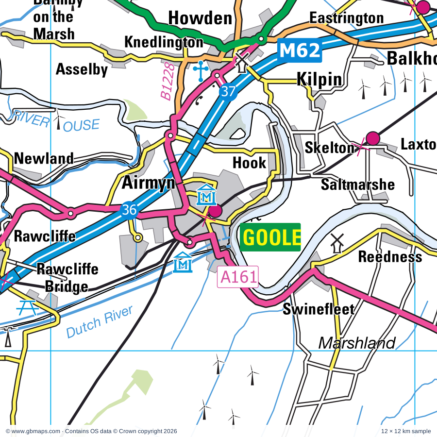
Goole regional road map. Full 60 × 60 km PDF, SVG and Illustrator files, with a free PDF sample.

GBMAPS.COM

Goole Regional Road Map

Call Us Now for Help01751 473136

GREAT BRITAIN ROAD ATLAS · 1:250,000 RY-42

Goole & surrounding area

Explore the full 60 × 60 km Goole regional road map at 1:250,000, covering Goole, Scunthorpe, Selby, Bridge, Humber. Compare the complete coverage below; a detailed PDF sample is available free.

GOOLE & SURROUNDING AREAREGIONAL ROAD MAP
60 × 60 km · Full map previewDownload the free SVG ↓

INSIDE THE FULL 60 × 60 KM MAP

Explore the Goole map area

1:250,000 cartography

Towns, villages & places

More mapped places (273)
  • Conisbrough
  • Maltby
  • Reedness
  • Whitgift
  • Swinefleet
  • Eastoft
  • Ousefleet
  • Saltmarshe
  • Luddington
  • Adlingfleet
  • Yokefleet
  • Fockerby
  • Garthorpe
  • Laxton
  • Blacktoft
  • Hook
  • Skelton
  • Kilpin
  • Faxfleet
  • Amcotts
  • Balkholme
  • Alkborough
  • Flixborough
  • Ealand
  • Normanby
  • Airmyn
  • Gilberdyke
  • Thealby
  • Gunness
  • Coleby
  • Eastrington
  • Keadby
  • Knedlington
  • Broomfleet
  • Portington
  • Althorpe
  • Whitton
  • Sandholme
  • Burringham
  • Asselby
  • Moorends
  • Newport
  • Derrythorpe
  • Rawcliffe
  • Newland
  • Brind
  • Newsholme
  • Roxby
  • Sandtoft
  • Belton
  • High Risby
  • Beltoft
  • Winteringham
  • Bursea
  • Welham Bridge
  • Low Risby
  • Spaldington
  • Drax
  • Long Drax
  • Wressle
  • Santon
  • Ellerker
  • Carlton
  • Brough
  • Fishlake
  • Snaith
  • Willitoft
  • Appleby
  • Gribthorpe
  • Everthorpe
  • Camblesforth
  • Hemingbrough
  • Elloughton
  • Breighton
  • Sand Hole
  • Hotham
  • Brantingham
  • Hatfield
  • Sykehouse
  • Welton
  • Moor End
  • Stainforth
  • Barlow
  • Foggathorpe
  • Dunscroft
  • Messingham
  • Gowdall
  • Susworth
  • Cliffe
  • Harlthorpe
  • Bubwith
  • Pollington
  • Horkstow
  • Wroot
  • South Newbald
  • Lund
  • Scotterthorpe
  • Braithwaite
  • Dunsville
  • Owston Ferry
  • Broughton
  • Riplingham
  • North Ferriby
  • Wressle
  • Laytham
  • North Newbald
  • East Lound
  • Haxey
  • Great Heck
  • Westwoodside
  • Bonby
  • Scotter
  • Aughton
  • Fenwick
  • Osgodby
  • Moss
  • Swanland
  • Hensall
  • Balne
  • Graizelound
  • Sancton
  • High Hunsley
  • Barlby
  • Ellerton
  • Manton
  • Wildsworth
  • Worlaby
  • Scawby
  • Burn
  • Edenthorpe
  • Brayton
  • Everingham
  • Scotton
  • Skipwith
  • Laughton
  • Armthorpe
  • Blaxton
  • Shiptonthorpe
  • Bielby
  • Whitley
  • Eggborough
  • Auckley
  • Branton
  • Finningley
  • Thorganby
  • Melbourne
  • Wrawby
  • Askern
  • Willerby
  • Elsham
  • Goodmanham
  • Northorpe
  • Hibaldstow
  • Anlaby
  • Riccall
  • Kellington
  • Skidby
  • Blyton
  • Gateforth
  • Thornton
  • Misterton
  • Arksey
  • Norton
  • Hayton
  • Wistow
  • Walkington
  • Burnham
  • Sutton
  • Redbourne
  • Londesborough
  • Campsall
  • Burnby
  • Womersley
  • Hambleton
  • Pilham
  • Walkerith
  • Beal
  • Cadney
  • Kellingley
  • Misson
  • Bentley
  • Allerthorpe
  • Grayingham
  • Bishop Burton
  • Wheldrake
  • Walkeringham
  • Burghwallis
  • Birkin
  • Rossington
  • Kelfield
  • Aisby
  • Escrick
  • Cawood
  • Bigby
  • Blyborough
  • Austerfield
  • Wootton
  • Howsham
  • Corringham
  • Elvington
  • Stillingfleet
  • Etton
  • Deighton
  • Biggin
  • Willoughton
  • Waddingham
  • Croxton
  • South Dalton
  • North Kelsey
  • Hillam
  • Searby
  • Everton
  • Hampole
  • Loversall
  • Dunswell
  • Snitterby
  • Scaftworth
  • Woodmansey
  • Brandy Wharf
  • Ryther
  • Sprotbrough
  • Leconfield
  • Hemswell
  • Marr
  • Thearne
  • Brodsworth
  • Naburn
  • Wadworth
  • Atterby
  • Grasby
  • Scrooby
  • Weel
  • Lund
  • Bishop Norton
  • Scorborough
  • Bircotes
  • Lockington
  • Wawne
  • Arram
  • Harworth
  • Moortown
  • Tickton
  • Cadeby
  • Ulleskelf
  • Bishopthorpe
  • Beswick
  • Thornton le Moor
  • Meaux
  • Styrrup
  • Kilnwick
  • Glentham
  • Colton
  • Copmanthorpe
  • Holton le Moor
  • Aike
  • Stainton
  • North Owersby
  • Clifton
  • Routh
  • Braithwell
  • Bishopbridge
  • Watton
  • Kingerby
  • Bilbrough
  • Kirkby
  • Micklebring
  • Catterton
  • Osgodby
  • Usselby
  • Angram
  • Burshill
  • Hellaby
  • Healaugh

Roads across this sheet

M18, M62, M180, M181, A1(M), A15, A18, A19, A46, A60, A63, A159, A161, A162, A163, A164, A165, A614, A630, A631, A634, A635, A638, A639

More road numbers

A645, A659, A1029, A1033, A1034, A1035, A1036, A1041, A1077, A1079, A1084, A1103, A1105, A1146, A1165, A1166, A1174, A1237, A1238, A6023, A6182, A6201, B1204, B1205, B1206, B1207, B1208, B1211, B1216, B1218, B1220, B1222, B1223, B1228, B1230, B1231, B1232, B1233, B1246, B1247, B1248, B1392, B1396, B1398, B1400, B1402, B1403, B1430, B1433, B1434, B1450, B1501, B6045, B6094, B6376, B6422, B6427, B6463

Rivers & waterways

Aire & Calder Navigation, Chesterfield Canal, Dutch River, Holderness Drain, Land Drain, Leven Canal, Market Weighton Canal, New Junction Canal, New River Ancholme, North Kelsey Beck, Old River Ancholme, Pocklington Canal

More waterways

River Aire, River Ancholme, River Dearne, River Derwent, River Don, River Dun Navigation, River Eau, River Foulness, River Hull, River Idle, River Ouse, River Ryton, River Torne, River Went, River Wharfe, Selby Canal, Sheffield & South Yorkshire Navigation, Stainforth & Keadby Canal, Watton Beck

Landmarks & landscape

Barlow Common Nature Reserve, Baysgarth House Museum, Wilderspin National School, Belton, Beverley Art Gallery, Beverley Minster, Beverley Racecourse, Blacktoft Sands, Brandy Wharf Cider Centre, Brodsworth Hall and Gardens, Brumby Common, Burnby Hall Gardens, Campsall Country Park

More named features

Carlton Towers, Conisbrough Castle, Conisbrough Castle and Visitor Centre, Cusworth Country Park, Denaby Ings Nature Reserve, Doncaster Museum & Art Gallery, Doncaster Aeroventure, Doncaster Racecourse, Elsham Hall Country Park, Epworth Old Rectory, Far Ings NNR Visitor Centre, Far Ings Nature Reserve, Gainsborough Old Hall, Gainsthorpe Medieval Village, Goole Museum and Art Gallery, Hall Park Farm, Haxey Nature Reserve, Haxey Reserve, Hemswell Craft and Design Centre, Highfields Country Park, Howden Church, Humber Bridge Country Park, Johnstones Farm Centre, Julians's Bower, King's Wood, Kirton Pottery, Lower Derwent Valley National Nature Reserve, Maltby Low Common, Melton Wood Country Park, Mount Pleasant Mill, Museum of South Yorkshire Life, Normanby Hall, Normanby Hall Country Park, Normanby Park Fishing Museum, National Fishing Heritage Centre, Normanby Hall, North Lincs Museum, Owston Ferry The Old Smithy and Heritage Centre, Potteric Carr Nature Reserve, Pulfin Bog Nature Reserve, Sandall Beat Wood Nature Reserve, Sandtoft Transport Centre, Selby Abbey, Skidby Windmill and Museum of East Riding Life, Skipwith Common Nature Reserve, South Ferriby Marina, Sprotbrough Flash, St Peter's Church, Stewart's Collection Museum, Stillingfleet Lodge Gardens, The Pink Pig, The Real Aeroplane Co Ltd, The Waterways Museum, Thorpe Marsh Nature Reserve, Tophill Low Nature Reserve, Tophill Low Nature Reserve Visitor Centre, Visitor Centre, Waters Edge Country Park, Watton Nature Reserve, Wheldrake Ings Nature Reserve, York Racecourse, Yorkshire Air Museum, Yorkshire Wildlife Centre
Local authority & parish coverage

Wholly or partly within the full map rectangle. These boundaries are coverage information, not additional artwork layers.

  • Bassetlaw DistrictPartly within
  • City of Kingston upon HullPartly within
  • Doncaster DistrictPartly within
  • East Riding of YorkshirePartly within
  • North LincolnshirePartly within
  • North YorkshirePartly within
  • Rotherham DistrictPartly within
  • Wakefield DistrictPartly within
  • West Lindsey DistrictPartly within
  • YorkPartly within
Wards & electoral divisions 125 areas
  • Ackworth, North Elmsall & Upton Ward (part)
  • Adwick le Street & Carcroft Ward
  • Armthorpe Ward
  • Ashby Central Ward
  • Ashby Lakeside Ward
  • Avenue Ward
  • Axholme Central Ward
  • Axholme North Ward
  • Axholme South Ward
  • Balby South Ward
  • Barton Ward
  • Beckingham Ward (part)
  • Bentley Ward
  • Bessacarr Ward
  • Beverley & Newland Ward (part)
  • Beverley Rural Ward (part)
  • Bishopthorpe Ward
  • Blyth Ward (part)
  • Boothferry Ward
  • Bottesford Ward
  • Bramley & Ravenfield Ward (part)
  • Bricknell Ward
  • Brigg & Wolds Ward
  • Broughton & Scawby Ward
  • Brumby Ward
  • Burringham & Gunness Ward
  • Burton upon Stather & Winterton Ward
  • Caistor and Yarborough Ward (part)
  • Central Ward (part)
  • Clayworth Ward (part)
  • Conisbrough Ward (part)
  • Copmanthorpe Ward
  • Cottingham North Ward
  • Cottingham South Ward
  • Crosby & Park Ward
  • Dale Ward
  • Derringham Ward
  • Dinnington Ward (part)
  • Dringhouses & Woodthorpe Ward (part)
  • Drypool Ward (part)
  • East Wolds and Coastal Ward (part)
  • Edenthorpe & Kirk Sandall Ward
  • Edlington & Warmsworth Ward
  • Everton Ward (part)
  • Ferry Ward (part)
  • Finningley Ward
  • Fishergate Ward (part)
  • Frodingham Ward
  • Fulford & Heslington Ward (part)
  • Gainsborough East Ward (part)
  • Gainsborough North Ward
  • Gainsborough South-West Ward (part)
  • Goole North Ward
  • Goole South Ward
  • Harworth Ward
  • Hatfield Ward
  • Hellaby & Maltby West Ward (part)
  • Hemswell Ward (part)
  • Hessle Ward
  • Hexthorpe & Balby North Ward
  • Holderness Ward (part)
  • Howden Ward
  • Howdenshire Ward
  • Hull Road Ward (part)
  • Kelsey Wold Ward (part)
  • Kingsway with Lincoln Gardens Ward
  • Kingswood Ward (part)
  • Knottingley & Ferrybridge Ward (part)
  • Maltby East Ward (part)
  • Market Rasen Ward (part)
  • Messingham Ward
  • Mexborough Ward (part)
  • Micklegate Ward (part)
  • Mid Holderness Ward (part)
  • Minster and Woodmansey Ward
  • Misterton Ward
  • Newington & Gipsyville Ward
  • North Carr Ward (part)
  • Norton & Askern Ward
  • Orchard Park Ward
  • Osbaldwick & Derwent Ward (part)
  • Pickering Ward
  • Pocklington Provincial Ward (part)
  • Pontefract South Ward (part)
  • Ranskill Ward (part)
  • Ridge Ward
  • Roman Ridge Ward
  • Rossington & Bawtry Ward
  • Rural West York Ward (part)
  • Scotter and Blyton Ward
  • Snaith, Airmyn, Rawcliffe and Marshland Ward
  • South Hunsley Ward
  • Sprotbrough Ward (part)
  • St. Andrew's & Docklands Ward (part)
  • St. Mary's Ward
  • Stainforth & Barnby Dun Ward
  • Thorne & Moorends Ward
  • Thurcroft & Wickersley South Ward (part)
  • Tickhill & Wadsworth Ward (part)
  • Town Ward
  • Town Ward
  • Tranby Ward
  • University Ward
  • Waddingham and Spital Ward (part)
  • West Carr Ward (part)
  • Westfield Ward (part)
  • Wheatley Hills & Intake Ward
  • Wheldrake Ward
  • Willerby and Kirk Ella Ward
  • Wold View Ward (part)
  • Wolds Weighton Ward (part)
  • Appleton Roebuck & Church Fenton ED (part)
  • Barlby & Riccall ED
  • Brayton & Barlow ED
  • Camblesforth & Carlton ED
  • Cawood & Escrick ED
  • Cliffe & North Duffield ED
  • Monk Fryston & South Milford ED (part)
  • Osgoldcross ED (part)
  • Ouseburn ED (part)
  • Selby East ED
  • Selby West ED
  • Sherburn in Elmet ED (part)
  • Tadcaster ED (part)
  • Thorpe Willoughby & Hambleton ED
Civil parishes & communities 323 areas
  • Acaster Malbis CP
  • Acaster Selby CP
  • Airmyn CP
  • Alkborough CP
  • Allerthorpe CP
  • Amcotts CP
  • Anlaby with Anlaby Common CP
  • Appleby CP
  • Appleton Roebuck CP
  • Armthorpe CP
  • Ashby Parkland CP
  • Askern CP
  • Askham Bryan CP (part)
  • Askham Richard CP
  • Asselby CP
  • Auckley CP
  • Austerfield CP
  • Balne CP
  • Barkston Ash CP (part)
  • Barlby with Osgodby CP
  • Barlow CP
  • Barmby Moor CP (part)
  • Barmby on the Marsh CP
  • Barnburgh CP (part)
  • Barnby Dun with Kirk Sandall CP
  • Barnetby Le Wold CP
  • Barrow upon Humber CP
  • Barton CP
  • Bawtry CP
  • Beal CP
  • Beckingham CP (part)
  • Belton CP
  • Beswick CP (part)
  • Beverley CP
  • Bielby CP
  • Bigby CP
  • Biggin CP
  • Bilbrough CP
  • Birkin CP
  • Bishop Burton CP
  • Bishop Norton CP
  • Bishopthorpe CP
  • Blacktoft CP
  • Blaxton CP
  • Blyborough CP
  • Blyth CP (part)
  • Blyton CP
  • Bolton Percy CP
  • Bonby CP
  • Bottesford CP
  • Braithwell CP (part)
  • Bramley CP (part)
  • Brandesburton CP (part)
  • Brantingham CP
  • Brayton CP
  • Brigg CP
  • Brodsworth CP (part)
  • Broomfleet CP
  • Brotherton CP (part)
  • Broughton CP
  • Bubwith CP
  • Burghwallis CP
  • Burn CP
  • Burringham CP
  • Burton Salmon CP (part)
  • Burton upon Stather CP
  • Byram cum Sutton CP (part)
  • Cadeby CP
  • Cadney CP
  • Caenby CP (part)
  • Caistor CP (part)
  • Camblesforth CP
  • Cantley CP
  • Carlton CP
  • Catterton CP (part)
  • Cawood CP
  • Chapel Haddlesey CP
  • Cherry Burton CP
  • Church Fenton CP
  • Claxby CP (part)
  • Cliffe CP
  • Colton CP
  • Conisbrough Parks CP (part)
  • Copmanthorpe CP
  • Corringham CP (part)
  • Cottingham CP
  • Cottingwith CP
  • Cridling Stubbs CP (part)
  • Crowle and Ealand CP
  • Croxton CP (part)
  • Dalton Holme CP
  • Darrington CP (part)
  • Deighton CP
  • Drax CP
  • Dunnington CP (part)
  • East Butterwick CP
  • East Ferry CP
  • East Stockwith CP
  • Eastoft CP
  • Eastrington CP
  • Edenthorpe CP
  • Edlington CP
  • Eggborough CP
  • Ellerker CP
  • Ellerton CP
  • Elloughton-cum-Brough CP
  • Elsham CP
  • Elvington CP
  • Epworth CP
  • Escrick CP
  • Etton CP
  • Everingham CP
  • Everton CP (part)
  • Fenwick CP
  • Finningley CP
  • Fishlake CP
  • Flixborough CP
  • Foggathorpe CP
  • Fulford CP
  • Gainsborough CP (part)
  • Garthorpe and Fockerby CP
  • Gateforth CP
  • Gilberdyke CP
  • Glentham CP (part)
  • Goodmanham CP
  • Goole CP
  • Goole Fields CP
  • Gowdall CP
  • Goxhill CP (part)
  • Grasby CP (part)
  • Grayingham CP
  • Great Limber CP (part)
  • Grimston CP (part)
  • Gringley on the Hill CP (part)
  • Gunness CP
  • Hambleton CP
  • Hampole CP (part)
  • Harpswell CP (part)
  • Harworth Bircotes CP
  • Hatfield CP
  • Haxey CP
  • Hayton CP
  • Healaugh CP (part)
  • Heck CP
  • Hellaby CP (part)
  • Hemingbrough CP
  • Hemswell CP
  • Hemswell Cliff CP (part)
  • Hensall CP
  • Heslington CP (part)
  • Hessle CP
  • Hibaldstow CP
  • Hickleton CP (part)
  • High Melton CP (part)
  • Hillam CP (part)
  • Hirst Courtney CP
  • Holme upon Spalding Moor CP
  • Holton Le Moor CP
  • Hook CP
  • Hooton Levitt CP
  • Horkstow CP
  • Hotham CP
  • Howden CP
  • Keadby with Althorpe CP
  • Kelfield CP
  • Kellington CP
  • Kexby CP (part)
  • Kilpin CP
  • Kirk Bramwith CP
  • Kirk Ella CP
  • Kirk Smeaton CP (part)
  • Kirkby Wharfe with North Milford CP (part)
  • Kirmington CP (part)
  • Kirton in Lindsey CP
  • Laughton CP
  • Laughton-en-le-Morthen CP (part)
  • Laxton CP
  • Leconfield CP
  • Leven CP (part)
  • Little Fenton CP
  • Little Smeaton CP
  • Lockington CP
  • Londesborough CP
  • Long Drax CP
  • Long Marston CP (part)
  • Loversall CP
  • Luddington and Haldenby CP
  • Lund CP
  • Maltby CP (part)
  • Manton CP
  • Market Weighton CP
  • Marr CP (part)
  • Mattersey CP (part)
  • Melbourne CP
  • Melton Ross CP
  • Messingham CP
  • Middle Rasen CP (part)
  • Middleton CP (part)
  • Misson CP
  • Misterton CP
  • Molescroft CP
  • Monk Fryston CP (part)
  • Morton CP
  • Moss CP
  • Naburn CP
  • Nettleton CP (part)
  • New Holland CP
  • Newbald CP
  • Newland CP
  • Newport CP
  • Newton on Derwent CP (part)
  • North Cave CP
  • North Dalton CP (part)
  • North Duffield CP
  • North Ferriby CP
  • North Kelsey CP
  • Northorpe CP
  • Norton CP
  • Nunburnholme CP (part)
  • Osgodby CP (part)
  • Owersby CP
  • Owston CP
  • Owston Ferry CP
  • Oxton CP (part)
  • Pilham CP
  • Pocklington CP (part)
  • Pollington CP
  • Ravenfield CP (part)
  • Rawcliffe CP
  • Redbourne CP
  • Reedness CP
  • Riccall CP
  • Rossington CP
  • Routh CP (part)
  • Rowley CP
  • Roxby cum Risby CP
  • Rufforth with Knapton CP (part)
  • Ryther cum Ossendyke CP
  • Sancton CP
  • Saxby All Saints CP
  • Saxton with Scarthingwell CP (part)
  • Scaftworth CP
  • Scawby CP
  • Scotter CP
  • Scotton CP
  • Scrooby CP (part)
  • Searby cum Owmby CP (part)
  • Seaton Ross CP
  • Selby CP
  • Sherburn in Elmet CP (part)
  • Shipton Thorpe CP
  • Skidby CP
  • Skipwith CP
  • Snaith and Cowick CP
  • Snitterby CP
  • Somerby CP
  • South Cave CP
  • South Cliffe CP
  • South Ferriby CP
  • South Kelsey CP
  • South Milford CP (part)
  • Spaldington CP
  • Springthorpe CP (part)
  • Sprotbrough and Cusworth CP
  • Stainforth CP
  • Stainton CP
  • Stapleton CP (part)
  • Steeton CP
  • Stillingfleet CP
  • Stubbs Walden CP
  • Styrrup with Oldcotes CP (part)
  • Sutton upon Derwent CP
  • Swanland CP
  • Swinefleet CP
  • Sykehouse CP
  • Tadcaster CP (part)
  • Temple Hirst CP
  • Thonock CP
  • Thorganby CP
  • Thorne CP
  • Thornton CP
  • Thornton Curtis CP (part)
  • Thorpe Willoughby CP
  • Thorpe in Balne CP
  • Thurcroft CP (part)
  • Tickhill CP
  • Tickton CP
  • Twin Rivers CP
  • Ulceby CP (part)
  • Ulleskelf CP
  • Upton and North Elmsall CP (part)
  • Waddingham CP
  • Wadworth CP
  • Walkeringham CP
  • Walkerith CP
  • Walkington CP
  • Warmsworth CP
  • Warter CP (part)
  • Watton CP (part)
  • Wawne CP (part)
  • Welton CP
  • West Butterwick CP
  • West Haddlesey CP
  • West Halton CP
  • West Rasen CP (part)
  • West Stockwith CP
  • Wheldrake CP
  • Whitley CP
  • Whitton CP
  • Wildsworth CP
  • Willerby CP
  • Willoughton CP
  • Winteringham CP
  • Winterton CP
  • Wiseton CP (part)
  • Wistow CP
  • Womersley CP
  • Woodmansey CP
  • Wootton CP
  • Worlaby CP
  • Wrawby CP
  • Wressle CP
  • Wroot CP

Source: the GBMaps road atlas, OS Boundary-Line and postcode mapping datasets. Source editions are being checked for publication. Unmarked boundary names are wholly within the sheet; “part” means the map edge crosses the area.

Place lists are selected from the map source, not a complete gazetteer. Named features describe the cartography; visitor facilities and opening status are not verified. The free sample covers only 12 × 12 km of this larger sheet.

INSIDE YOUR DOWNLOAD

A proper road map, in useful formats

Road classifications, towns and villages, railways, rivers, landscape detail and tourist symbols, brought together in the GBMaps regional road atlas style.

PDF filePDFSVG fileSVGAdobe Illustrator AI fileAi

PDF for the finished map. SVG and layered Illustrator artwork for adapting colours, adding your own information and preparing designs.

THE FINISHED SHEET

Designed for print and presentation

Map coverage
60 × 60 km
Sample coverage
12 × 12 km
Print layout
A3 landscape · enlarged 1:250k cartography
Sheet furniture
Border, scale bar, key & north arrow

A few useful details

What changes when I select another square?

Select a surrounding square to bring it into the centre and reveal the maps around it. Each square is a different 60 × 60 km map. The preview, free sample and selected download change together. Neighbouring sheets overlap by 30 km so you can choose the coverage that suits you.

Is the free sample a vector map?

The on-page detail is an SVG. The free download is a separate 12 × 12 km PDF with a link to the full map. Please retain its copyright credits and product link when sharing it.

Can I buy a larger combined map?

These downloads are individual ready-made sheets. Contact GBMaps if you need a larger combined area.

FREE PDF SAMPLE

Your free map sample

Your free 12 × 12 km sample includes a link back to this map, so you can return for the full area whenever you need it.

Download free PDF sample ↓

Get your Goole map

Map download bundle

£24.00including VATOne payment

Pay securely

One payment. Your map stays open.

Your map download

Your map files

Preparing your download…

Checking your private download link…

Your map downloads

Already bought a map?

Find the downloads from your purchases.

Enter the email address you used at checkout. We’ll email you a private link to your available map downloads.