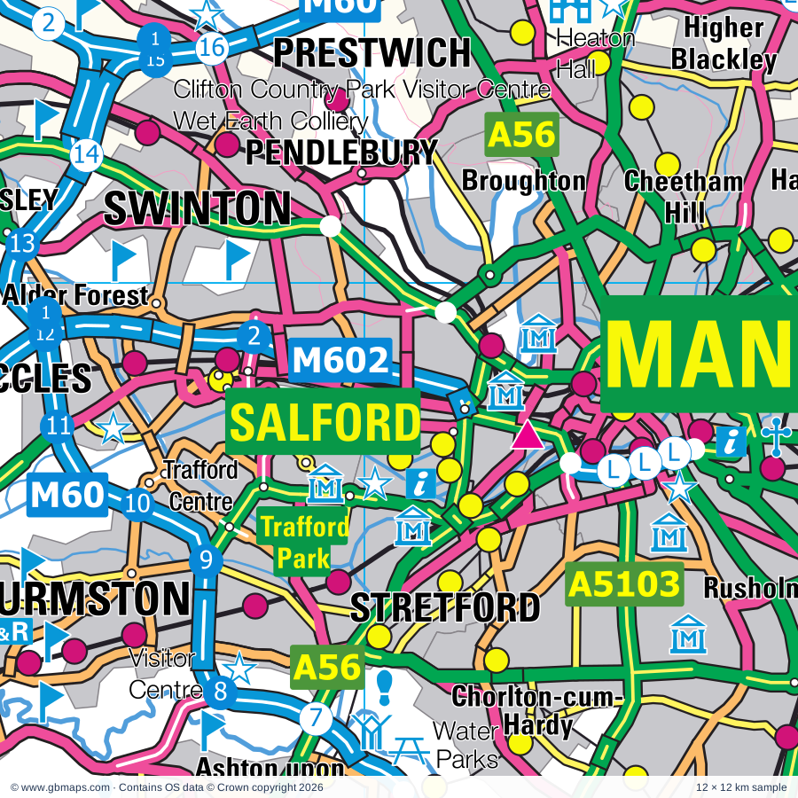
Salford regional road map. Full 60 × 60 km PDF, SVG and Illustrator files, with a free PDF sample.

GBMAPS.COM

Salford Regional Road Map

Call Us Now for Help01751 473136

GREAT BRITAIN ROAD ATLAS · 1:250,000 GB-360-0390

Salford & surrounding area

Explore the full 60 × 60 km Salford regional road map at 1:250,000, covering Liverpool, Manchester, Chester, Warrington, Golborne. Compare the complete coverage below; a detailed PDF sample is available free.

SALFORD & SURROUNDING AREAREGIONAL ROAD MAP
60 × 60 km · Full map previewDownload the free SVG ↓

INSIDE THE FULL 60 × 60 KM MAP

Explore the Salford map area

1:250,000 cartography

Towns, villages & places

More mapped places (231)

Roads across this sheet

M6, M53, M56, M57, M58, M60, M61, M62, M66, M602, A6, A34, A41, A49, A50, A51, A54, A56, A57, A57(M), A58, A59, A62, A483

More road numbers

A506, A507, A526, A527, A530, A533, A534, A535, A536, A537, A538, A540, A548, A549, A550, A551, A552, A553, A554, A555, A556, A557, A558, A559, A560, A561, A562, A565, A566, A567, A568, A569, A570, A571, A572, A573, A574, A575, A576, A577, A578, A579, A580, A581, A599, A626, A627(M), A635, A640, A662, A663, A664, A665, A666, A667, A669, A671, A673, A674, A675, A676, A680, A5014, A5018, A5022, A5027, A5028, A5029, A5030, A5032, A5033, A5034, A5036, A5037, A5038, A5039, A5040, A5044, A5046, A5047, A5048, A5049, A5050, A5053, A5054, A5055, A5056, A5058, A5060, A5061, A5062, A5063, A5066, A5067, A5068, A5079, A5080, A5081, A5082, A5088, A5089, A5090, A5098, A5102, A5103, A5104, A5106, A5115, A5116, A5117, A5118, A5137, A5139, A5143, A5144, A5145, A5147, A5149, A5181, A5184, A5185, A5186, A5207, A5208, A5209, A5227, A5267, A5268, A5300, A5480, A5509, A5758, A6010, A6027, A6041, A6042, A6044, A6045, A6046, A6047, A6053, A6060, A6099, A6104, A6143, A6144, A6145, B545, B5074, B5075, B5079, B5081, B5082, B5083, B5085, B5086, B5087, B5093, B5094, B5095, B5117, B5125, B5129, B5130, B5132, B5133, B5134, B5136, B5137, B5142, B5143, B5144, B5145, B5146, B5147, B5148, B5149, B5150, B5151, B5152, B5153, B5155, B5156, B5157, B5158, B5159, B5160, B5161, B5162, B5163, B5164, B5165, B5166, B5167, B5168, B5169, B5171, B5172, B5173, B5174, B5175, B5177, B5178, B5179, B5180, B5186, B5187, B5188, B5189, B5192, B5193, B5194, B5195, B5197, B5198, B5199, B5200, B5201, B5202, B5203, B5204, B5205, B5206, B5207, B5208, B5209, B5210, B5211, B5212, B5213, B5214, B5215, B5217, B5218, B5219, B5224, B5228, B5229, B5230, B5231, B5232, B5235, B5236, B5237, B5238, B5239, B5240, B5241, B5242, B5243, B5244, B5245, B5246, B5247, B5248, B5249, B5250, B5251, B5252, B5253, B5276, B5280, B5308, B5309, B5311, B5312, B5318, B5319, B5320, B5339, B5355, B5356, B5357, B5358, B5359, B5374, B5375, B5376, B5391, B5392, B5393, B5397, B5407, B5408, B5413, B5419, B5421, B5422, B5424, B5439, B5441, B5445, B5463, B5465, B5471, B6167, B6178, B6180, B6186, B6187, B6189, B6195, B6196, B6198, B6199, B6202, B6203, B6204, B6205, B6206, B6207, B6208, B6209, B6212, B6213, B6214, B6215, B6216, B6218, B6219, B6221, B6222, B6223, B6224, B6226, B6227, B6228, B6229, B6266, B6292, B6377, B6391, B6393, B6402, B6452, B6469, B6472, B6473, B6527, B6536
Rivers & waterways

Ashton Canal, Bridgewater Canal, Canal, Leeds & Liverpool Canal, Macclesfield Canal, Manchester Ship Canal, Manchester, Bolton & Bury Canal (disused), Manchester, Bolton and Bury Canal (disused), River Alt, River Bollin, River Dane, River Dean

More waterways

River Dee / Afon Dyfrdwy, River Douglas, River Irwell, River Mersey, River Roch, River Tame, River Weaver, River Wheelock, River Yarrow, Rochdale Canal, Shropshire Union Canal, Shropshire Union Canal (Middlewich Branch), St Helens Canal (disused), Trent & Mersey Canal, Trent and Mersey Canal, Weaver Navigation, Wincham Brook

Landmarks & landscape

Acorn Venture Urban Farm, Active Adventures, Aintree Racecourse, Albert Dock, Tate Liverpool, The Beatles Story Pier Head, Alderley Edge, Anderton Boat Lift, Animal World, Applejacks Farm, Arley Hall, Arley Hall and Gardens, Astbury Mere Country Park, Astley Green Colliery Museum

More named features

Astley Hall, Baguley Hall, Beacon Country Park, Belle Vue Stadium, Birkenhead Park Visitor Centre, Blackleach Country Park & Visitor Centre, Bluebell Cottage Gardens, Boggart Hole Clough Visitor Centre, Bolton Aquarium, Bolton Museum, Art Gallery, Aquarium, Botanic Gardens Museum, Bramhall Hall, Brereton Heath Park, Brimstage Hall Courtyard, British Lawnmower Museum, Burrs Country Park, Calderstones and Harthill Botanic Gardens, Capesthorne Hall, Cheshire Craft Workshop (Blakemere Village), Chester Cathedral, Chester Racecourse, Chester Roman Amphitheatre, Chester Castle, Agricola Tower and Castle Walls, Chester Zoo, Childrens Zoo, Chorlton Water Park, Chorlton Water Sports, Chorlton Water Park (Fishing), City of Manchester Stadium, Egerton Narrow Boats, The Manchester Evening News Arena, Chetham's Library, National Cycling Centre, Clifton Country Park, Clifton Country Park Visitor Centre, Wet Earth Colliery, Clock Face Country Park, Cotebrook Shire Horse Centre, Croxteth Country Park, Croxteth Hall, Croxteth Home Farm, Jungle Parc Activity Centre, Cuckoo Clock Museum, Dibbinsdale Nature Reserve, Dunham Massey, Dunham Massey Hall, Dunham Massey Hall Garden, East Lancashire Railway, Eastham Country Park, Eaton Hall, Eaton Hall Point to Point Course, Eccles Farm Craft Centre, Esplanade Arts and Heritage Centre, Touchstones Rochdale, Farmer Ted's Farm Park, Fletcher Moss Botanical and Parsonage Gardens, Foxhill Arboretum, Gallery of English Costume, Gauntlet Birds of Prey Centre, Gawsworth Hall, Go Ape Delamare, Go Ape Rivington, Greenacres Farm Park, Grosvenor Museum, Cheshire Military Museum, Chester Toy and Doll Museum, Chester Heritage Centre, Guildhall Museum, Gulliver's (Warrington), Hadlow Road Station, Haigh Country Park, Hall, Hall i'th Wood, Halton Castle, Hare Hill Garden, Hatch Mere Nature Reserve, Haydock Park Racecourse, Healey Dell Nature Reserve, Heaton Hall, Heaton Park, Heaton Park Animal Centre, Heaton Park Tram Museum, Hillside Bird Oasis, Hockenhull Platts Packhorse Bridge, Horwich Heritage Centre, Imperial War Museum North, Jumbles Country Park, Knowsley Hall, Knowsley Safari Park, Knutsford Heritage Centre, Lady Heyes Crafts & Antiques Centre, Lady Lever Art Gallery, Lancashire Fusiliers Regimental Museum, Bury Art Gallery and Museum, Bury Transport Museum, Lancaster Park Animal Farm, Laserquest, Leisure Lakes, Linmere Visitor Centre, Little Budworth Country Park, Liverpool FC Museum and Tour Centre, Liverpool Museum, Western Approaches Museum, Conservation Centre, Planetarium, Victoria Gallery and Museum, Liverpool-Maritime Mercantile City (World Heritage Site), Manchester C of E Cathedral, Manchester City Art Gallery, Museum of Science & Industry, The Pump House (Peoples History Museum), Manchester Swimming Complex, Manchester United Museum, Ordsall Hall Museum, Marbury Park Country Park, Martin Mere Nature Reserve, Megabowl Bowling Alley, Mere Sands Wood Nature Reserve, Mersey Valley Visitor Centre, Cloverfield Riding Centre, Metropolitan Cathedral, Liverpool Cathedral, Moses Gate Country Park, Mount Pleasant Gardens, Museum of Liverpool Life, Merseyside Maritime Museum, HM Customs and Excise National Museum, The Beatles Story, Museum of Transport, Manchester Jewish Museum, Urbis, National Wildflower Centre, Nelson Pit Visitor Centre, Ness Botanic Gardens, Nether Alderley Mill, New Pleasureland, North West Museum of Road Transport, World of Glass, Northwich Salt Museum, The Dock Road Edwardian Pumping Station, Norton Priory Museum, Norton Priory Walled Garden, Old Hall, Orrell Water Park, Oulton Park Motor Racing Circuit, Peel Tower, Pennington Flash Country Park, Pennington Flash Country Park Visitor Centre, Peover Hall, Perch Rock (Beauty Spot), Pickerings Pasture, Port Sunlight Heritage Centre, Prescot Museum, Quarry Bank Mill, Ramsbottom Heritage Gallery, Rice Lane City Farm, Rimrose Valley Country Park, Risley Moss Nature Park, Riveracre Country Park, Rivington Country Park, Rixton Claypits Nature Reserve, Rochdale Pioneers Museum, Greater Manchester Fire Service Museum, Rufford Old Hall, Sale Water Park, Salford Art Gallery and Museum, Viewpoint Photography Gallery, Sandbach Crosses, Sankey Valley Country Park Visitor Centre, Sankey Valley Park, Sefton Park Palm House, Smithhills Open Farm, Smithills Country Park, Smithills Hall, Snidley Moor Wood Nature Reserve, Southport Model Railway Village, Spaceport, Speke Hall, Spike Island Visitor Centre, Catalyst Science Discovery Centre, Wigg Island Visitor Centre, Stadt Moers Country Park, Stanney Woods Country Park, Stockley Farm, Sudley Art Gallery, Sunlight Vision Museum and Visitor Centre, Tabley House, Tatton Hall, Tatton Home Farm, Tatton Park, Textile Museum, The Blue Planet Aquarium, The Corgi Heritage Centre, The Last Drop Village, The Manchester Museum, Pankhurst Centre, Whitworth Art Gallery, The National Waterways Museum, The Quinta Aboretum, The Theatre Organ Heritage Centre, The Walker, FACT, University of Liverpool Art Gallery, Open Eye Gallery, The Way We Were Heritage Centre, Opie's Museum of Memories, Wigan Life, The Whitworth Museum, The Wirral Country Park, Three Sisters Racing Circuit, Trafford Park Heritage Centre, HMS Bronington, The Lowry, Turton Tower, Visitor Centre, Visitor Centre, Granada Arboretum, Walton Hall, Walton Hall Gardens, Warrington Indoor Tennis Centre, Warrington Museum & Art Gallery, Water Ski Centre, Wigan Pier, Williamson Art Gallery and Museum, Pacific Road Museum, U Boat Story, Williamson Tunnels, Windmill Farm (Animal Farm), Wythenshaw Community Farm, Wythenshawe Hall, Yarrow Valley Park Country Park, Yarrow Valley Visitor Centre

Local authority & parish coverage

Wholly or partly within the full map rectangle. These boundaries are coverage information, not additional artwork layers.

  • Blackburn with DarwenPartly within
  • Bolton DistrictWholly within
  • Bury DistrictWholly within
  • Cheshire EastPartly within
  • Cheshire West and ChesterPartly within
  • Chorley DistrictPartly within
  • HaltonWholly within
  • Knowsley DistrictWholly within
  • Liverpool DistrictWholly within
  • Manchester DistrictPartly within
  • Oldham DistrictPartly within
  • Rochdale DistrictPartly within
  • Rossendale DistrictPartly within
  • Salford DistrictWholly within
  • Sefton DistrictPartly within
  • Sir y Fflint - FlintshirePartly within
  • South Ribble DistrictPartly within
  • St. Helens DistrictWholly within
  • Staffordshire Moorlands DistrictPartly within
  • Stockport DistrictPartly within
  • Tameside DistrictPartly within
  • Trafford DistrictWholly within
  • WarringtonWholly within
  • West Lancashire DistrictPartly within
  • Wigan DistrictWholly within
  • Wirral DistrictPartly within
  • Wrecsam - WrexhamPartly within
Wards & electoral divisions 474 areas
  • Abram Ward
  • Adlington & Anderton Ward
  • Aigburth Ward
  • Ainsdale Ward (part)
  • Aintree & Maghull South Ward
  • Alderley Edge Ward
  • Allerton Ward
  • Altrincham Ward
  • Ancoats & Beswick Ward
  • Anfield Ward
  • Appleton Ward
  • Appleton Ward
  • Ardwick Ward
  • Arundel Ward
  • Ashton upon Mersey Ward
  • Ashton-in-Makerfield South Ward
  • Aspull, New Springs & Whelley Ward
  • Astley Bridge Ward
  • Astley Ward
  • Atherton North Ward
  • Atherton South & Lilford Ward
  • Audenshaw Ward (part)
  • Aughton & Holborn Ward
  • Baguley Ward
  • Balderstone & Kirkholt Ward (part)
  • Bamford Ward
  • Bankfield Ward
  • Barton & Winton Ward
  • Bebington Ward (part)
  • Beechwood & Heath Ward
  • Belle Vale Ward
  • Besses Ward
  • Bewsey & Whitecross Ward
  • Biddulph North Ward (part)
  • Bidston and St. James Ward (part)
  • Billinge & Seneley Green Ward
  • Birchfield Ward
  • Birchwood Ward
  • Birkdale Ward
  • Birkenhead and Tranmere Ward
  • Blackbrook Ward
  • Blackfriars & Trinity Ward
  • Blacon Ward
  • Blundellsands Ward (part)
  • Bold & Lea Green Ward
  • Boothstown & Ellenbrook Ward
  • Bootle East Ward
  • Bootle West Ward
  • Bowdon Ward
  • Bradshaw Ward
  • Bramhall North Ward (part)
  • Bramhall South & Woodford Ward (part)
  • Breightmet Ward
  • Brereton Rural Ward (part)
  • Bridgewater Ward
  • Brinnington & Stockport Central Ward (part)
  • Britannia & Lee Mill Ward (part)
  • Broadgreen Ward
  • Broadheath Ward
  • Broken Cross and Upton Ward (part)
  • Bromborough Ward
  • Bromley Cross Ward
  • Brooklands Ward
  • Brooklands Ward
  • Broughton Ward
  • Brownlow Hill Ward
  • Bryn with Ashton-in-Makerfield North Ward
  • Bucklow-St. Martins Ward
  • Buckshaw & Whittle Ward (part)
  • Bunbury Ward (part)
  • Burnage Ward
  • Burscough Bridge & Rufford Ward (part)
  • Burscough Town Ward
  • Burtonwood & Winwick Ward
  • Bury East Ward
  • Bury West Ward
  • Cadishead & Lower Irlam Ward
  • Calderstones Ward
  • Cambridge Ward (part)
  • Canning Ward
  • Castleton Ward (part)
  • Central & Grange Ward
  • Central & West Bank Ward
  • Central Rochdale Ward (part)
  • Chadderton Central Ward (part)
  • Chadderton North Ward (part)
  • Chadderton South Ward (part)
  • Chapelford & Old Hall Ward
  • Charlestown Ward
  • Cheadle East & Cheadle Hulme North Ward
  • Cheadle Hulme South Ward
  • Cheadle West & Gatley Ward
  • Cheetham Ward
  • Chelford Ward
  • Cherryfield Ward
  • Chester City & the Garden Quarter Ward
  • Childwall Ward
  • Chorley East Ward
  • Chorley North & Astley Ward (part)
  • Chorley North East Ward (part)
  • Chorley North West Ward
  • Chorley South East & Heath Charnock Ward
  • Chorley South West Ward
  • Chorlton Park Ward
  • Chorlton Ward
  • Christleton & Huntington Ward (part)
  • Church Ward
  • City Centre North Ward
  • City Centre South Ward
  • Claremont Ward
  • Clatterbridge Ward (part)
  • Claughton Ward (part)
  • Clayton & Openshaw Ward (part)
  • Clubmoor East Ward
  • Clubmoor West Ward
  • Congleton East Ward (part)
  • Congleton West Ward
  • Coppull Ward
  • County Ward
  • Croston, Mawdesley & Euxton South Ward (part)
  • Croxteth Country Park Ward
  • Croxteth Ward
  • Crumpsall Ward
  • Culcheth, Glazebury & Croft Ward
  • Dane Valley Ward
  • Daresbury, Moore & Sandymoor Ward
  • Darwen South Ward (part)
  • Darwen West Ward (part)
  • Davenham, Moulton & Kingsmead Ward
  • Davenport & Cale Green Ward (part)
  • Davyhulme Ward
  • Deansgate Ward
  • Denton West Ward (part)
  • Didsbury East Ward
  • Didsbury West Ward
  • Dingle Ward
  • Ditton, Hale Village & Halebank Ward
  • Douglas Ward
  • Droylsden East Ward (part)
  • Droylsden West Ward (part)
  • Duke's Ward (part)
  • East Middleton Ward
  • Eastham Ward
  • Eccles Ward
  • Eccleston Ward
  • Eccleston, Heskin & Charnock Richard Ward
  • Edge Hill Ward
  • Edgeley Ward
  • Elton Ward
  • Euxton Ward (part)
  • Everton East Ward
  • Everton North Ward
  • Everton West Ward
  • Failsworth East Ward (part)
  • Failsworth West Ward (part)
  • Fairfield & Howley Ward
  • Fallowfield Ward
  • Farndon Ward (part)
  • Farnworth North Ward
  • Farnworth South Ward
  • Farnworth Ward
  • Fazakerley East Ward
  • Fazakerley North Ward
  • Fazakerley West Ward
  • Festival Gardens Ward
  • Flixton Ward
  • Ford Ward
  • Formby East Ward (part)
  • Formby West Ward (part)
  • Frodsham Ward
  • Garston Ward
  • Gateacre Ward
  • Gawsworth Ward (part)
  • Golborne & Lowton West Ward
  • Gorse Hill & Cornbrook Ward
  • Gorton & Abbey Hey Ward (part)
  • Gowy Rural Ward
  • Grange Ward
  • Grappenhall Ward
  • Grassendale & Cressington Ward
  • Great Boughton Ward
  • Great Crosby Ward
  • Great Lever Ward
  • Great Sankey North & Whittle Hall Ward
  • Great Sankey South Ward
  • Greenbank Park Ward
  • Greenfield & Eden Ward (part)
  • Hale Barns & Timperley South Ward
  • Hale Ward
  • Halewood North Ward
  • Halewood South Ward
  • Halliwell Ward
  • Halton Castle Ward
  • Halton Lea Ward
  • Halton View Ward
  • Handbridge Park Ward
  • Handforth Ward
  • Hareholme & Waterfoot Ward (part)
  • Harpurhey Ward
  • Hartford & Greenbank Ward
  • Haydock Ward
  • Heald Green Ward
  • Healey Ward (part)
  • Heaton, Lostock & Chew Moor Ward
  • Heatons North Ward
  • Heatons South Ward
  • Helmshore Ward (part)
  • Helsby Ward
  • High Legh Ward
  • Higher Blackley Ward
  • Higher Irlam & Peel Green Ward
  • Highfield Ward
  • Hindley Green Ward
  • Hindley Ward
  • Holyrood Ward
  • Hopwood Hall Ward
  • Horwich North Ward
  • Horwich South & Blackrod Ward
  • Hough Green Ward
  • Hulme Ward
  • Hulton Ward
  • Ince Ward
  • Kearsley Ward
  • Kensington & Fairfield Ward
  • Kersal & Broughton Park Ward
  • Kew Ward
  • Kirkdale East Ward
  • Kirkdale West Ward
  • Knotty Ash & Dovecot Park Ward
  • Knutsford Ward
  • Lache Ward
  • Latchford East Ward
  • Latchford West Ward
  • Ledsham & Manor Ward
  • Leigh Central & Higher Folds Ward
  • Leigh South Ward
  • Leigh West Ward
  • Levenshulme Ward
  • Liscard Ward (part)
  • Litherland Ward
  • Little Hulton Ward
  • Little Lever & Darcy Lever Ward
  • Little Neston Ward (part)
  • Longford Ward
  • Longsight Ward
  • Lostock & Barton Ward
  • Lowton East Ward
  • Lydiate & Maghull West Ward
  • Lymm North & Thelwall Ward
  • Lymm South Ward
  • Macclesfield South Ward (part)
  • Macclesfield West and Ivy Ward (part)
  • Maghull East Ward
  • Manor Ward (part)
  • Manor Ward
  • Marbury Ward
  • Meols Ward (part)
  • Mersey & Weston Ward
  • Middlewich Ward
  • Miles Platting & Newton Heath Ward
  • Milkstone & Deeplish Ward (part)
  • Mobberley Ward
  • Moorside Ward
  • Moss Bank Ward
  • Moss Side Ward
  • Mossley Hill Ward
  • Moston Ward
  • Much Woolton & Hunts Cross Ward
  • Neston Ward (part)
  • Netherpool Ward
  • Netherton North Ward
  • Netherton South & Orrell Ward
  • New Brighton Ward (part)
  • Newton & Hoole Ward
  • Newton-le-Willows East Ward
  • Newton-le-Willows West Ward
  • Norbury & Woodsmoor Ward (part)
  • Norden Ward
  • Norris Green Ward
  • North Heywood Ward
  • North Manor Ward
  • North Meols & Hesketh Bank Ward (part)
  • North Middleton Ward (part)
  • Northenden Ward
  • Northwich Leftwich Ward
  • Northwich Winnington & Castle Ward
  • Northwich Witton Ward
  • Northwood Ward
  • Norton North Ward
  • Norton South & Preston Brook Ward
  • Norwood Ward
  • Odd Rode Ward (part)
  • Old Moat Ward
  • Old Skelmersdale Ward
  • Old Swan East Ward
  • Old Swan West Ward
  • Old Trafford Ward
  • Ordsall Ward
  • Orford Ward
  • Ormskirk East Ward
  • Ormskirk West Ward
  • Orrell Park Ward
  • Orrell Ward
  • Oxton Ward (part)
  • Page Moss Ward
  • Parr Ward
  • Peasley Cross & Fingerpost Ward
  • Pemberton Ward
  • Pendlebury & Clifton Ward
  • Pendleton & Charlestown Ward
  • Penketh & Cuerdley Ward
  • Penny Lane Ward
  • Piccadilly Ward
  • Pilkington Park Ward
  • Poplars & Hulme Ward
  • Poulton North Ward
  • Poulton South Ward
  • Poynton West and Adlington Ward (part)
  • Prenton Ward (part)
  • Prescot North Ward
  • Prescot South Ward
  • Prestbury Ward (part)
  • Princes Park Ward
  • Quays Ward
  • Queens Park & Central Ward
  • Radcliffe East Ward
  • Radcliffe North & Ainsworth Ward
  • Radcliffe West Ward
  • Rainford Ward
  • Rainhill Ward
  • Ramsbottom Ward
  • Reddish North Ward (part)
  • Reddish South Ward (part)
  • Redvales Ward
  • Rixton & Woolston Ward
  • Roby Ward
  • Rock Ferry Ward
  • Royton North Ward (part)
  • Rudheath Ward
  • Rumworth Ward
  • Rural North East Ward
  • Rural South Ward
  • Rural West Ward
  • Rusholme Ward
  • Sale Central Ward
  • Sale Moor Ward
  • Sandbach Elworth Ward
  • Sandbach Ettiley Heath and Wheelock Ward (part)
  • Sandbach Heath and East Ward (part)
  • Sandbach Town Ward
  • Sandfield Park Ward
  • Sandstone Ward
  • Saughall & Mollington Ward
  • Seacombe Ward (part)
  • Sedgley Ward
  • Sefton Park Ward
  • Seven Stars Ward (part)
  • Shakerley Ward
  • Sharston Ward
  • Shevington Ward
  • Shevington with Lower Ground & Moor Ward
  • Skelmersdale North Ward
  • Skelmersdale South Ward
  • Smithdown Ward
  • Smithills Ward
  • South Middleton Ward
  • Speke Ward
  • Spotland & Falinge Ward
  • Springwood Ward
  • St Mary's Ward
  • St. Gabriels Ward
  • St. Helens Town Centre Ward
  • St. Michaels Ward
  • St. Michaels Ward
  • Standish with Langtree Ward
  • Stockbridge Ward
  • Stockton Heath Ward
  • Stoneycroft Ward
  • Strawberry Ward
  • Stretford & Humphrey Park Ward
  • Sutton North West Ward
  • Sutton South East Ward
  • Sutton Villages Ward
  • Swanside Ward
  • Swinton & Wardley Ward
  • Swinton Park Ward
  • Tanhouse & Skelmersdale Town Centre Ward
  • Tarleton Village Ward (part)
  • Tarporley Ward
  • Tarvin & Kelsall Ward
  • Tattenhall Ward (part)
  • Thatto Heath Ward
  • Thornton & Hightown Ward (part)
  • Timperley Central Ward
  • Timperley North Ward
  • Tonge with the Haulgh Ward
  • Tottington Ward
  • Toxteth Ward
  • Tuebrook Breckside Park Ward
  • Tuebrook Larkhill Ward
  • Tyldesley & Mosley Common Ward
  • Unsworth Ward
  • Up Holland Ward
  • Upton Ward
  • Urmston Ward
  • Vauxhall Ward
  • Walkden North Ward
  • Walkden South Ward
  • Wallasey Ward (part)
  • Walton Ward
  • Wardle, Shore & West Littleborough Ward (part)
  • Waterfront North Ward
  • Waterfront South Ward
  • Waterloo Ward
  • Wavertree Garden Suburb Ward
  • Wavertree Village Ward
  • Weaste & Seedley Ward
  • Weaver & Cuddington Ward
  • West Derby Deysbrook Ward
  • West Derby Leyfield Ward
  • West Derby Muirhead Ward
  • West Heywood Ward
  • West Middleton Ward
  • West Park Ward
  • West Pennine Ward (part)
  • Westbrook Ward
  • Westhoughton North & Hunger Hill Ward
  • Westhoughton South Ward
  • Westminster Ward
  • Whalley Range Ward
  • Whiston & Cronton Ward
  • Whitby Groves Ward
  • Whitby Park Ward
  • Whitefield Ward
  • Whitewell & Stacksteads Ward (part)
  • Whitworth Ward (part)
  • Wigan Central Ward
  • Wigan West Ward
  • Willaston & Thornton Ward (part)
  • Wilmslow Dean Row Ward
  • Wilmslow East Ward
  • Wilmslow Lacey Green Ward
  • Wilmslow West and Chorley Ward
  • Windle Ward
  • Winsford Dene Ward
  • Winsford Gravel Ward
  • Winsford Over & Verdin Ward
  • Winsford Swanlow Ward
  • Winsford Wharton Ward
  • Winstanley Ward
  • Withington Ward
  • Wolverham Ward
  • Woodhouse Park Ward
  • Woolton Village Ward
  • Worsley & Westwood Park Ward
  • Worsley Mesnes Ward
  • Yew Tree Ward
  • Broughton North East ED
  • Broughton South ED
  • Buckley: Pentrobin ED (part)
  • Connah's Quay Central ED (part)
  • Connah's Quay: Golftyn ED (part)
  • Connah's Quay: Wepre ED (part)
  • Hawarden: Aston ED (part)
  • Hawarden: Ewloe ED (part)
  • Hawarden: Mancot ED
  • Higher Kinnerton ED (part)
  • Hope ED (part)
  • Pen-y-ffordd ED (part)
  • Queensferry and Sealand ED
  • Rossett ED (part)
  • Saltney Ferry ED
  • Shotton East and Shotton Higher ED
  • Shotton West ED (part)
Civil parishes & communities 266 areas
  • Acton Bridge CP
  • Adlington CP (part)
  • Adlington CP
  • Aintree Village CP
  • Alderley Edge CP
  • Aldford and Saighton CP (part)
  • Allostock CP
  • Alpraham and Calveley CP (part)
  • Alvanley CP
  • Anderton CP
  • Anderton with Marbury CP
  • Anglezarke CP
  • Antrobus CP
  • Appleton CP
  • Arclid CP
  • Ashley CP
  • Ashton Hayes and Horton-cum-Peel CP
  • Astley Village CP
  • Aston By Budworth CP
  • Aston CP
  • Aughton CP
  • Bache CP
  • Backford CP
  • Barnton CP
  • Barrow CP
  • Beeston CP (part)
  • Betchton CP (part)
  • Bexton CP
  • Bickerstaffe CP
  • Biddulph CP (part)
  • Billinge Chapel End CP
  • Birchwood CP
  • Bispham CP
  • Blackrod CP
  • Bold CP
  • Bostock CP
  • Bradwall CP
  • Brereton CP
  • Bretherton CP (part)
  • Broughton and Bretton Community
  • Buckley Community (part)
  • Burscough CP
  • Burtonwood and Westbrook CP
  • Byley CP
  • Capenhurst CP
  • Carrington CP
  • Charnock Richard CP
  • Chelford CP
  • Chester Castle CP
  • Cholmondeston CP (part)
  • Chorley CP
  • Christleton CP
  • Church Minshull CP (part)
  • Clotton Hoofield CP
  • Comberbach CP
  • Congleton CP (part)
  • Connah's Quay Community (part)
  • Coppull CP
  • Cranage CP
  • Croft CP
  • Cronton CP
  • Croston CP
  • Croughton CP
  • Crowton CP
  • Cuddington CP
  • Cuerdley CP
  • Culcheth and Glazebury CP
  • Dalton CP
  • Daresbury CP
  • Darnhall CP
  • Darwen CP (part)
  • Davenham CP
  • Delamere and Oakmere CP
  • Dodleston CP (part)
  • Downholland CP
  • Duddon and Burton CP
  • Dunham Massey CP
  • Dunham-on-the-Hill and Hapsford CP
  • Dutton CP
  • Eaton CP
  • Eaton and Eccleston CP (part)
  • Eccleston CP
  • Eccleston CP
  • Elton CP
  • Euxton CP (part)
  • Formby CP (part)
  • Frodsham CP
  • Gawsworth CP (part)
  • Golborne David CP (part)
  • Goostrey CP
  • Grappenhall and Thelwall CP
  • Great Altcar CP
  • Great Boughton CP
  • Great Budworth CP
  • Great Sankey CP
  • Great Warford CP
  • Guilden Sutton CP
  • Haigh CP
  • Hale CP
  • Halebank CP
  • Halewood CP
  • Halsall CP
  • Handforth CP
  • Hargrave and Huxley CP
  • Hartford CP
  • Hatton CP
  • Hawarden Community (part)
  • Heapey CP (part)
  • Heath Charnock CP
  • Helsby CP
  • Henbury CP
  • Heskin CP
  • High Legh CP
  • Higher Kinnerton Community (part)
  • Hightown CP (part)
  • Hilldale CP
  • Holmes Chapel CP
  • Hope Community (part)
  • Horwich CP
  • Hulme Walfield CP
  • Huntington CP
  • Ince Blundell CP (part)
  • Ince CP
  • Kelsall CP
  • Kingsley CP
  • Kingsmead CP
  • Knowsley CP
  • Knutsford CP
  • Lach Dennis and Lostock Green CP
  • Lathom CP
  • Lathom South CP
  • Lea-by-Backford CP
  • Ledsham CP
  • Little Altcar CP (part)
  • Little Bollington with Agden CP
  • Little Budworth CP
  • Little Leigh CP
  • Little Stanney CP
  • Little Warford CP
  • Littleton CP
  • Lostock Gralam CP
  • Lower Withington CP
  • Lydiate CP
  • Lymm CP
  • Macclesfield CP (part)
  • Maghull CP
  • Manley CP
  • Marston CP
  • Marthall CP
  • Marton CP
  • Mawdesley CP
  • Melling CP
  • Mere CP
  • Mickle Trafford and District CP
  • Middlewich CP
  • Millington and Rostherne CP
  • Minshull Vernon CP (part)
  • Mobberley CP
  • Mollington CP
  • Moore CP
  • Moreton cum Alcumlow CP (part)
  • Moston CP (part)
  • Moston CP
  • Mottram St. Andrew CP
  • Mouldsworth CP
  • Moulton CP
  • Neston CP (part)
  • Nether Alderley CP
  • Nether Peover CP
  • Newbold Astbury CP (part)
  • Newburgh CP
  • Norley CP
  • North Meols CP (part)
  • North Rode CP (part)
  • North Turton CP (part)
  • Northwich CP
  • Ollerton CP
  • Over Alderley CP
  • Parbold CP
  • Partington CP
  • Penketh CP
  • Penyffordd Community (part)
  • Peover Inferior CP
  • Peover Superior and Snelson CP
  • Pickmere CP
  • Plumley CP
  • Poulton and Pulford CP (part)
  • Poulton-with-Fearnhead CP
  • Prescot CP
  • Prestbury CP (part)
  • Preston Brook CP
  • Puddington CP
  • Queensferry Community
  • Rainford CP
  • Rainhill CP
  • Ringway CP
  • Rivington CP
  • Rixton-with-Glazebrook CP
  • Rossett Community (part)
  • Rowton CP
  • Rudheath CP
  • Rufford CP
  • Rushton CP
  • Saltney Community
  • Sandbach CP (part)
  • Sandymoor CP
  • Saughall and Shotwick Park CP
  • Scarisbrick CP
  • Sealand Community
  • Sefton CP
  • Seneley Green CP
  • Shevington CP
  • Shotton Community (part)
  • Siddington CP
  • Simonswood CP
  • Smallwood CP (part)
  • Somerford Booths CP
  • Somerford CP
  • Sproston CP
  • Stanthorne and Wimboldsley CP
  • Stoak CP
  • Stockton Heath CP
  • Stretton CP
  • Styal CP
  • Sutton Weaver CP
  • Swettenham CP
  • Tabley Inferior CP
  • Tabley Superior CP
  • Tarleton CP (part)
  • Tarporley CP
  • Tarvin CP
  • Tattenhall and District CP (part)
  • Thornton CP
  • Thornton-le-Moors CP
  • Tiverton and Tilstone Fearnall CP (part)
  • Tockholes CP (part)
  • Toft CP
  • Twemlow CP
  • Ulnes Walton CP (part)
  • Up Holland CP
  • Upton-by-Chester CP
  • Utkinton and Cotebrook CP
  • Walton CP
  • Warburton CP
  • Warmingham CP (part)
  • Waverton CP
  • Weaverham CP
  • Wervin CP
  • Westhoughton CP
  • Wettenhall CP (part)
  • Wheelton CP (part)
  • Whiston CP
  • Whitegate and Marton CP
  • Whitley CP
  • Whittle-le-Woods CP (part)
  • Whitworth CP (part)
  • Willington CP
  • Wilmslow CP
  • Wincham CP
  • Windle CP
  • Winsford CP
  • Winwick CP
  • Withnell CP (part)
  • Woolston CP
  • Worthington CP
  • Wrightington CP

Source: the GBMaps road atlas, OS Boundary-Line and postcode mapping datasets. Source editions are being checked for publication. Unmarked boundary names are wholly within the sheet; “part” means the map edge crosses the area.

Place lists are selected from the map source, not a complete gazetteer. Named features describe the cartography; visitor facilities and opening status are not verified. The free sample covers only 12 × 12 km of this larger sheet.

INSIDE YOUR DOWNLOAD

A proper road map, in useful formats

Road classifications, towns and villages, railways, rivers, landscape detail and tourist symbols, brought together in the GBMaps regional road atlas style.

PDF filePDFSVG fileSVGAdobe Illustrator AI fileAi

PDF for the finished map. SVG and layered Illustrator artwork for adapting colours, adding your own information and preparing designs.

THE FINISHED SHEET

Designed for print and presentation

Map coverage
60 × 60 km
Sample coverage
12 × 12 km
Print layout
A3 landscape · enlarged 1:250k cartography
Sheet furniture
Border, scale bar, key & north arrow

A few useful details

What changes when I select another square?

Select a surrounding square to bring it into the centre and reveal the maps around it. Each square is a different 60 × 60 km map. The preview, free sample and selected download change together. Neighbouring sheets overlap by 30 km so you can choose the coverage that suits you.

Is the free sample a vector map?

The on-page detail is an SVG. The free download is a separate 12 × 12 km PDF with a link to the full map. Please retain its copyright credits and product link when sharing it.

Can I buy a larger combined map?

These downloads are individual ready-made sheets. Contact GBMaps if you need a larger combined area.

FREE PDF SAMPLE

Your free map sample

Your free 12 × 12 km sample includes a link back to this map, so you can return for the full area whenever you need it.

Download free PDF sample ↓

Get your Salford map

Map download bundle

£24.00including VATOne payment

Pay securely

One payment. Your map stays open.

Your map download

Your map files

Preparing your download…

Checking your private download link…

Your map downloads

Already bought a map?

Find the downloads from your purchases.

Enter the email address you used at checkout. We’ll email you a private link to your available map downloads.