Nottingham regional road map. Full 60 × 60 km PDF, SVG and Illustrator files, with a free PDF sample.

GBMAPS.COM

Nottingham Regional Road Map

Call Us Now for Help01751 473136

GREAT BRITAIN ROAD ATLAS · 1:250,000 GB-480-0330

Nottingham & surrounding area

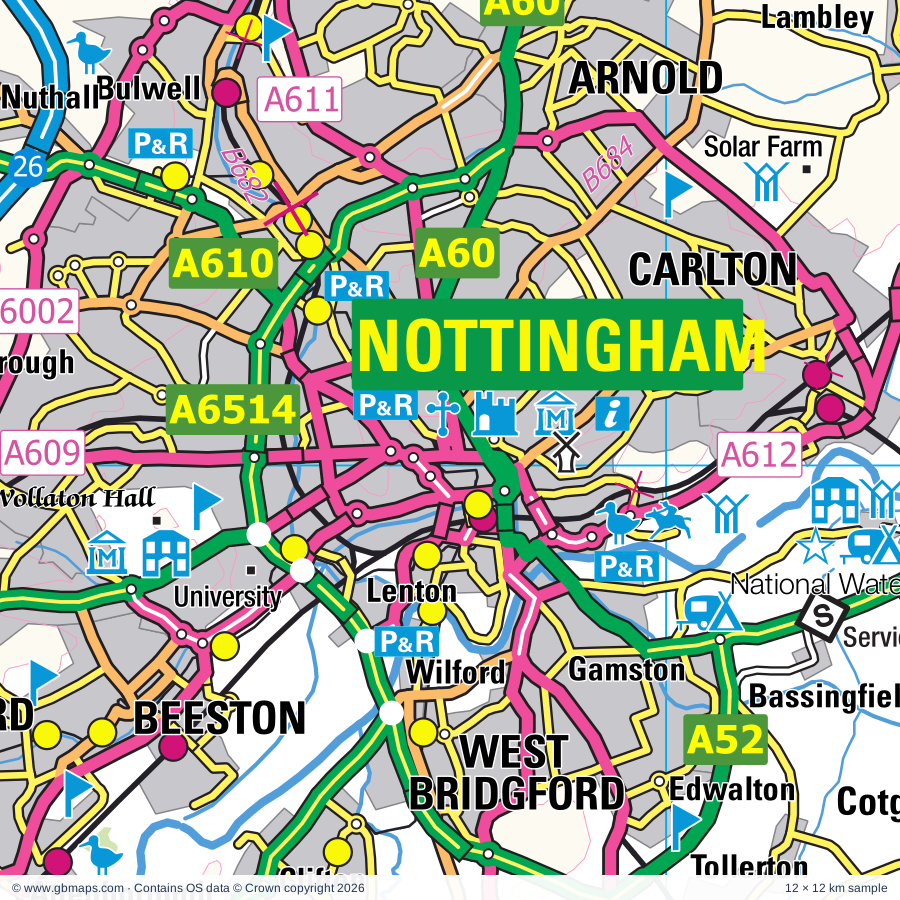
Explore the full 60 × 60 km Nottingham regional road map at 1:250,000, covering Nottingham, Bingham, Oakham, Syston, Southwell. Compare the complete coverage below; a detailed PDF sample is available free.

NOTTINGHAM & SURROUNDING AREAREGIONAL ROAD MAP
60 × 60 km · Full map previewDownload the free SVG ↓

INSIDE THE FULL 60 × 60 KM MAP

Explore the Nottingham map area

1:250,000 cartography

Towns, villages & places

More mapped places (356)
  • Harston
  • Plungar
  • Harby
  • Redmile
  • Chadwell
  • Wycomb
  • Stonesby
  • Saltby
  • Hose
  • Scalford
  • Denton
  • Long Clawson
  • Sproxton
  • Granby
  • Wyville
  • Muston
  • Sutton
  • Barnstone
  • Langar
  • Harlaxton
  • Bottesford
  • Holwell
  • Coston
  • Garthorpe
  • Freeby
  • Barrowby
  • Ab Kettleby
  • Thorpe Arnold
  • Saxby
  • Colston Bassett
  • Stroxton
  • Normanton
  • Skillington
  • Buckminster
  • Hickling
  • Wyfordby
  • Wartnaby
  • Nether Broughton
  • Brentingby
  • Orston
  • Aslockton
  • Allington
  • Stapleford
  • Stoke Rochford
  • Sewstern
  • Wymondham
  • Tithby
  • Kinoulton
  • Alverton
  • Great Ponton
  • Owthorpe
  • Kilvington
  • Asfordby Hill
  • Stainby
  • Flawborough
  • Scarrington
  • Burton Lazars
  • Easton
  • Saxelbye
  • Old Dalby
  • Grimston
  • Gunby
  • Foston
  • Hawksworth
  • Asfordby
  • Colsterworth
  • Shelton
  • Screveton
  • Shoby
  • Teigh
  • Westborough
  • Little Dalby
  • Sibthorpe
  • Newton
  • Belton
  • Leesthorpe
  • Marston
  • Great Dalby
  • Thistleton
  • Bassingthorpe
  • South Witham
  • Cotham
  • Widmerpool
  • Syston
  • Old Somerby
  • Clipston
  • Hougham
  • Ragdale
  • Londonthorpe
  • Westby
  • Barrow
  • Flintham
  • Barkston
  • Ashwell
  • Hoby
  • Birkholme
  • Rotherby
  • Shelford
  • Kneeton
  • Bitchfield
  • Syerston
  • Keyworth
  • Elston
  • Pickwell
  • Gunthorpe
  • Caythorpe
  • Plumtree
  • Welby
  • Cottesmore
  • Langham
  • Bassingfield
  • Honington
  • Somerby
  • Hoveringham
  • Wysall
  • Tollerton
  • Claypole
  • Ropsley
  • Greetham
  • Cold Overton
  • Thorpe
  • Stubton
  • Swayfield
  • Gaddesby
  • Humby
  • Stretton
  • Corby Glen
  • Thrussington
  • Wymeswold
  • Brandon
  • Ingoldsby
  • Barleythorpe
  • Gamston
  • Burley
  • Twyford
  • Hawton
  • Gonalston
  • Lowdham
  • Barsby
  • Edwalton
  • John O'Gaunt
  • Bleasby
  • Knossington
  • Rearsby
  • Bradmore
  • Carlton
  • Balderton
  • Bunny
  • Thurgarton
  • Clipsham
  • Seagrave
  • Normanton-on-Cliffe
  • Castle Bytham
  • Braceby
  • Owston
  • Oasby
  • Fenton
  • Sapperton
  • Sudbrook
  • Fiskerton
  • Lenton
  • Exton
  • Rempstone
  • Morton
  • Irnham
  • Marefield
  • South Croxton
  • Caythorpe
  • Lambley
  • East Goscote
  • Burton on the Wolds
  • Aisby
  • Ruddington
  • Walton on the Wolds
  • Costock
  • Swinstead
  • Heydour
  • Ancaster
  • Rolleston
  • Creeton
  • Queniborough
  • Keisby
  • Kelby
  • Hoton
  • Lowesby
  • Haceby
  • Epperstone
  • Egleton
  • Sutton
  • Prestwold
  • Wilsford
  • Woodborough
  • Staythorpe
  • Halloughton
  • Wilford
  • Sileby
  • Pickworth
  • Little Bytham
  • Hawthorpe
  • Culverthorpe
  • Brooke
  • Averham
  • Whitwell
  • Coddington
  • Halstead
  • Stragglethorpe
  • Clifton
  • Beckingham
  • Fulbeck
  • Upton
  • Hungarton
  • Pickworth
  • Dembleby
  • Cossington
  • Newton
  • Launde Abbey
  • Bulby
  • Beeby
  • Kelham
  • Careby
  • Aunsby
  • Grimsthorpe
  • Cotes
  • Barkby
  • Empingham
  • Gotham
  • Normanton
  • Mountsorrel
  • Walcot
  • Calverton
  • Elsthorpe
  • Keyham
  • Manton
  • Brant Broughton
  • Winthorpe
  • Leadenham
  • Swarby
  • Halam
  • Edenham
  • Quorndon
  • Folkingham
  • Oxton
  • Rothley
  • Loddington
  • Wanlip
  • Ridlington
  • Edith Weston
  • Tickencote
  • Hockerton
  • Lyndon
  • Thurmaston
  • Skeffington
  • Osbournby
  • Normanton
  • Billesdon
  • Thrumpton
  • Stainfield
  • Aslackby
  • Preston
  • Aswarby
  • Wing
  • Woodthorpe
  • Edingley
  • Stapleford
  • Bathley
  • Langford
  • Holme
  • Hanthorpe
  • Welbourn
  • Great Casterton
  • Brough
  • Birstall
  • Tugby
  • Pilton
  • Lound
  • Allexton
  • Threekingham
  • Ayston
  • Carlby
  • Toft
  • Winkburn
  • Graby
  • Thurcaston
  • Rippingale
  • Wardley
  • Carlton-le-Moorland
  • Kirklington
  • Woodhouse
  • Essendine
  • Cawthorpe
  • Spanby
  • Swithland
  • Morton
  • Rolleston
  • Caunton
  • Norton Disney
  • Ryhall
  • Manthorpe
  • Cranwell
  • Farnsfield
  • Hathern
  • Gaulby
  • Holdingham
  • Glaston
  • Tinwell
  • Cropston
  • Scredington
  • Belmesthorpe
  • Ketton
  • Leasingham
  • Nuthall
  • Morcott
  • Northorpe
  • Bassingham
  • Stoughton
  • Thurlby
  • Wellingore
  • Little Stretton
  • Braceborough
  • Papplewick
  • Anstey
  • Wilsthorpe
  • Barrowden
  • Wothorpe
  • Collyweston
  • Blidworth
  • Navenby
  • Linby
  • Greatford
  • Uffington
  • Tixover
  • Ravenshead
  • Oadby
  • Evedon
  • Duddington
  • Barholm
  • Rainworth
  • Ruskington
  • Groby
  • Bloxholm
  • Pilsgate
  • Newstead
  • Dorrington
  • Tallington
  • Barnack
  • Wittering
  • Ratby
  • Digby
  • Leicester Forest East
  • Bainton
  • Rowston
  • Scopwick
  • Ufford
  • Southorpe
  • Thornhaugh
  • Kirkby Green

Roads across this sheet

M1, M69, A1, A6, A15, A17, A38, A43, A46, A47, A50, A52, A60, A151, A153, A426, A453, A512, A563, A594, A606, A607, A608, A609

More road numbers

A610, A611, A612, A614, A616, A617, A1133, A1175, A5131, A5199, A5460, A5630, A6002, A6003, A6004, A6005, A6006, A6007, A6008, A6011, A6019, A6030, A6097, A6117, A6121, A6130, A6190, A6191, A6200, A6211, A6464, A6514, A6520, B568, B582, B589, B600, B640, B641, B667, B668, B672, B676, B679, B680, B682, B683, B684, B686, B690, B692, B1081, B1174, B1176, B1177, B1188, B1191, B1193, B1202, B1209, B1429, B1443, B1517, B1518, B4114, B5010, B5327, B5350, B5366, B5380, B5403, B5418, B6003, B6004, B6006, B6008, B6009, B6011, B6020, B6021, B6022, B6023, B6030, B6047, B6139, B6166, B6325, B6326, B6386, B6403, B6416, B6464, B6621

Rivers & waterways

Beeston Canal, Canal (disused), Dover Beck, East Glen River, Eye Brook, Fairham Brook, Foston Beck, Grand Union Canal, Grantham Canal (disused), Nottingham Canal, River Brant, River Chater

More waterways

River Devon, River Erewash, River Eye, River Glen, River Gwash, River Leen, River Maun, River Slea, River Soar, River Trent, River Welland, River Witham, River Wreake, Trent & Mersey Canal, West Glen River, Zouch Cut

Landmarks & landscape

Abbey, Ancaster Valley Nature Reserve, Moor Closes nature Reserve, Attenborough Gravel Pits Nature Reserve, Aylestone Meadows Nature Reserve, Baggrave Hall, Barnack Hills & Holes-BNR Nature Reserve, Barnsdale Gardens, Belgrave Gardens, Belgrave Hall Museum, Belgrave Hall Museum, Bellfoundry Museum, Great Central Railway, Old Rectory Museum, Charnwood Museum, Belton House, Belvoir Castle

More named features

Belvoir Castle Gardens, Bestwood Lodge Country Park, Bestwood Winding Engine House, Bradgate Country Park, Brewhouse Yard, Museum Of Costume & Textiles, Museum of Nottingham Lace, Green's Mill, Castle Museum & Art Gallery, William Booth Birthplace Museum, Broombriggs Farm Country Park, Browne's Hospital, Burghley House, Burntstump Country Park, Burrough Hill Country Park, Calverton Folk Museum, Carnegie Museum, Castle, Castle Hill Country Park, Cogglesford Watermill, Navigation House Visitor Centre, Colwick Country Park, Colwick Country Park Nature Reserve, Cotgrave Country Park, Cranwell Aviation Heritage Centre, Cranwell RAF College, Cropston Reservoir Nature Reserve, Crossroads Farm Museum, Croxton Park, Drought Garden and Arboretum, Easton Walled Gardens, Egleton Nature Reserve, Fairham Brook Nature Reserve, Ferry Farm, Gas Museum, Gedling Country Park, Gorse Hill City Farm, Grantham Museum, Great Central Railway, Great Central Railway (Nottingham), Grimsthorpe Castle, Grimsthorpe Castle and Garden, Grimsthorpe Garden, Guru Nanak Gurdwarna Sikh Museum, HUB, Hansons Chocolate House, High Wood Nature Reserve, Holly Copse Nature Reserve, Holme Pierrepoint Hall, Holme Pierrepont Country Park, National Water Sports Centre & Country Park, Jewry Wall Museum and Site, Kirby Muxloe Castle, Kirby Muxloe castle, Leen Valley Country Park, Leicester Cathedral, Leicester Racecourse, Londonthorpe Nature Reserve, Manor Farm Animal Centre, Melbourn Brothers Brewery, Stamford Arts Centre, Melton Country Park, Melton Country Park Visitor Centre, Mrs Smith's Cottage, NCCL Galleries of Justice, National Civil War Centre, National Space Centre, National Watersports Centre, Naturescape Wild Flower Farm, New Walk Museum & Art Gallery, Newarke Houses Museum, Newark Air Museum, Newark Boat Trips, Queens Sconc Visitor Centre, Newark Castle, Newark and Notts Agricultural Society Showground, Newstead Abbey, Newstead and Annesley Country Park, North Ings Farm Museum, Nottingham Castle, Nottingham Racecourse, Nottingham Transport Heritage Centre, Oakham Castle, Oakham Castle (remains of), Out Woods Nature Reserve, Papplewick Pumping Station, Patchings Farm Art Centre, Portland Park Visitor Centre, Power Station, Priest's House, Priory, RAF Digby OPS Room Museum, Reg Taylor's Swan and Wildfowl Sanctuary, Richard III Visitor Centre, Ropsley Wood Nature Reserve, Ruddington Country Park Nature Reserve, Ruddington Village Museum, Ruddington Framework Knitters Museum, Rushcliffe Country Park, Rutland County Museum, Rutland Falconry & Owl Centre, Rutland Open Air Theatre, Rutland Railway Museum, Rutland Water (North) Nature Reserve, Rutland Water Visitor Centre, Indoor Rock Climbing, Sacrewell Farm & Country Centre, Seller's Wood Nature Reserve, Solar Farm, South Witham Nature Reserve, Southorpe Paddock Nature Reserve, Southwell Minster, Southwell Racecourse, St Barnabas Cathedral, Stamford Castle, Stonehurst Family Farm and Museum, Swithland Reservoir Nature Reserve, Swithland Woods Nature Reserve, The Beacon Hill Country Park, The Flintham Museum, The Jain Centre, The Limekiln, The Mountsorrel Railway, The Pottery, The Workhouse, Tolethorpe Hall, Twinlakes Park, University of Leicester Botanic Garden, University of Nottingham, Visitor Centre, Wartnaby Gardens, Watermead Country Park, Whatoff Lodge Farm, Wheelgate Family Adventure Park, White Post Modern Farm Centre, Wing Maze, Wollaton Hall, Wollaton Yard Industrial Museum, Wollaton Hall Natural History Museum, Woolsthorpe Manor (Birthplace of Newton), Wymondham Windmill
Local authority & parish coverage

Wholly or partly within the full map rectangle. These boundaries are coverage information, not additional artwork layers.

  • Ashfield DistrictPartly within
  • Blaby DistrictPartly within
  • Broxtowe DistrictPartly within
  • Charnwood DistrictPartly within
  • City of LeicesterPartly within
  • City of NottinghamWholly within
  • City of PeterboroughPartly within
  • Erewash DistrictPartly within
  • Gedling DistrictWholly within
  • Harborough DistrictPartly within
  • Hinckley and Bosworth DistrictPartly within
  • Mansfield DistrictPartly within
  • Melton DistrictWholly within
  • Newark and Sherwood DistrictPartly within
  • North Kesteven DistrictPartly within
  • North NorthamptonshirePartly within
  • North West Leicestershire DistrictPartly within
  • Oadby and Wigston DistrictPartly within
  • Rushcliffe DistrictPartly within
  • RutlandPartly within
  • South Kesteven DistrictPartly within
Wards & electoral divisions 267 areas
  • Abbey Hill Ward
  • Abbey Ward
  • Abbey Ward
  • Annesley & Kirkby Woodhouse Ward (part)
  • Anstey Ward
  • Asfordby Ward
  • Ashby de la Launde, Digby & Scopwick Ward (part)
  • Aspley Ward
  • Attenborough & Chilwell East Ward
  • Aveland Ward (part)
  • Awsworth, Cossall & Trowell Ward (part)
  • Aylestone Ward (part)
  • Balderton North & Coddington Ward
  • Balderton South Ward
  • Barleythorpe Ward
  • Barnack Ward (part)
  • Barrow upon Soar Ward
  • Basford Ward
  • Bassingham Rural Ward (part)
  • Beacon Ward
  • Beaumont Leys Ward
  • Beeston Central Ward
  • Beeston North Ward
  • Beeston Rylands Ward
  • Beeston West Ward
  • Belgrave Ward
  • Belmont Ward
  • Belvoir Ward
  • Berridge Ward
  • Berry Hill Ward
  • Bestwood St. Albans Ward
  • Bestwood Ward
  • Bilborough Ward
  • Billesdon & Tilton Ward (part)
  • Billinghay Rural Ward (part)
  • Bilsthorpe Ward (part)
  • Bingham North Ward
  • Bingham South Ward
  • Birstall East & Wanlip Ward
  • Birstall West Ward
  • Bottesford Ward
  • Bourne Austerby Ward (part)
  • Bourne East Ward (part)
  • Bourne West Ward
  • Bramcote Ward (part)
  • Braunston & Martinsthorpe Ward (part)
  • Braunstone Millfield Ward
  • Braunstone Park & Rowley Fields Ward
  • Braunstone Ravenhurst Ward
  • Bridge Ward
  • Bulwell Forest Ward
  • Bulwell Ward
  • Bunny Ward
  • Calverton Ward
  • Carlton Hill Ward
  • Carlton Ward
  • Casewick Ward (part)
  • Castle Rock Ward (part)
  • Castle Ward
  • Castle Ward
  • Castle Ward
  • Castle Ward
  • Cavendish Ward
  • Chilwell West Ward (part)
  • Clifton East Ward
  • Clifton West Ward
  • Collingham Ward (part)
  • Colwick Ward
  • Compton Acres Ward
  • Coppice Ward
  • Cotgrave Ward
  • Cottesmore Ward
  • Cranmer Ward
  • Cranwell, Leasingham & Wilsford Ward (part)
  • Cropwell Ward
  • Croxton Kerrial Ward
  • Dales Ward
  • Daybrook Ward
  • Devon Ward
  • Dishley, Hathern & Thorpe Acre Ward (part)
  • Dole Wood Ward (part)
  • Dover Beck Ward
  • Dumbles Ward
  • East Bridgford Ward
  • Edwalton Ward
  • Enderby Ward (part)
  • Ernehale Ward
  • Evington Ward
  • Exton Ward
  • Eyres Monsell Ward (part)
  • Farndon & Fernwood Ward
  • Farnsfield Ward
  • Forest Bradgate Ward (part)
  • Fosse Normanton Ward (part)
  • Fosse Ward
  • Frisby-on-the-Wreake Ward
  • Gaddesby Ward
  • Gamston Ward
  • Gedling Ward
  • Glen Ward
  • Glen Ward (part)
  • Glenfield Ellis Ward
  • Glenfield Faire Ward
  • Gotham Ward (part)
  • Grange Farm Ward (part)
  • Grantham Arnoldfield Ward
  • Grantham Barrowby Gate Ward
  • Grantham Earlesfield Ward
  • Grantham Harrowby Ward
  • Grantham Springfield Ward
  • Grantham St. Vincent's Ward
  • Grantham St. Wulfram's Ward
  • Greasley Ward (part)
  • Greenwood & Summit Ward (part)
  • Greetham Ward
  • Groby Ward (part)
  • Heckington Rural Ward (part)
  • Helpringham & Osbournby Ward (part)
  • Hucknall Central Ward
  • Hucknall North Ward
  • Hucknall South Ward
  • Hucknall West Ward (part)
  • Humberstone & Hamilton Ward
  • Hyson Green & Arboretum Ward
  • Isaac Newton Ward
  • Ketton Ward (part)
  • Keyworth & Wolds Ward
  • Kimberley Ward (part)
  • Kings Walk Ward (part)
  • Kingsway Ward
  • Kirby Muxloe Ward (part)
  • Kirkby Cross & Portland Ward (part)
  • Kirkby la Thorpe & South Kyme Ward (part)
  • Knighton Ward
  • Lady Bay Ward
  • Langham Ward
  • Larwood Ward (part)
  • Leake Ward
  • Leamington Ward (part)
  • Leen Valley Ward
  • Leicester Forest & Lubbesthorpe Ward (part)
  • Lenton & Wollaton East Ward
  • Lincrest Ward
  • Lindhurst Ward
  • Ling Forest Ward (part)
  • Long Clawson and Stathern Ward
  • Loughborough Ashby Ward (part)
  • Loughborough East Ward
  • Loughborough Nanpantan Ward (part)
  • Loughborough Outwoods & Shelthorpe Ward (part)
  • Loughborough Southfields Ward
  • Loughborough Storer Ward
  • Loughborough Woodthorpe Ward
  • Loveden Heath Ward
  • Lowdham Ward
  • Lutterell Ward
  • Lyddington Ward (part)
  • Mapperley Ward
  • Markfield, Stanton and Fieldhead Ward (part)
  • Meadows Ward
  • Melton Craven Ward
  • Melton Dorian Ward
  • Melton Egerton Ward
  • Melton Newport Ward
  • Melton Sysonby Ward
  • Melton Warwick Ward
  • Metheringham Rural Ward (part)
  • Morton Ward (part)
  • Mountsorrel Ward
  • Muskham Ward (part)
  • Musters Ward
  • Narborough & Littlethorpe Ward (part)
  • Navenby & Brant Broughton Ward (part)
  • Netherfield Ward
  • Nevile & Langar Ward
  • Nevill Ward (part)
  • Newbold Verdon with Desford and Peckleton Ward (part)
  • Newstead Abbey Ward
  • Newton Ward
  • Normanton Ward
  • North Evington Ward
  • Nottingham Road Ward (part)
  • Nuthall East & Strelley Ward (part)
  • Oadby Brocks Hill Ward (part)
  • Oadby Grange Ward
  • Oadby St. Peter's Ward (part)
  • Oadby Uplands Ward
  • Oadby Woodlands Ward (part)
  • Oak Tree Ward (part)
  • Oakham North East Ward
  • Oakham North West Ward
  • Oakham South Ward
  • Oakham Ward (part)
  • Old Dalby Ward
  • Oundle Ward (part)
  • Peascliffe & Ridgeway Ward
  • Phoenix Ward
  • Plains Ward
  • Porchester Ward
  • Quorn & Mountsorrel Castle Ward
  • Radcliffe on Trent Ward
  • Radford Ward
  • Rainworth North & Rufford Ward (part)
  • Rainworth South & Blidworth Ward
  • Ratby, Bagworth and Thornton Ward (part)
  • Redhill Ward
  • Rothley Brook Ward
  • Ruddington Ward
  • Rushey Mead Ward
  • Ruskington Ward (part)
  • Ryhall & Casterton Ward
  • Saffron Ward
  • Sherwood Ward
  • Sileby & Seagrave Ward
  • Skegby Ward (part)
  • Sleaford Castle Ward
  • Sleaford Holdingham Ward
  • Sleaford Navigation Ward
  • Sleaford Quarrington & Mareham Ward
  • Sleaford Westholme Ward
  • Soar Valley Ward (part)
  • Somerby Ward
  • South Charnwood Ward
  • Southwell Ward (part)
  • Southwell Ward (part)
  • Spinney Hills Ward
  • St. Ann's Ward
  • Stamford All Saints Ward
  • Stamford St. George's Ward
  • Stamford St. John's Ward
  • Stamford St. Mary's Ward
  • Stapleford North Ward (part)
  • Stapleford South East Ward (part)
  • Stoneygate Ward
  • Sutton Central & New Cross Ward (part)
  • Sutton Junction & Harlow Wood Ward
  • Sutton-on-Trent Ward (part)
  • Syston Ward
  • The Wolds Ward
  • Thompsons Ward (part)
  • Thorpe Astley & St. Mary's Ward
  • Thurmaston Ward
  • Thurnby & Houghton Ward
  • Thurncourt Ward
  • Toller Ward (part)
  • Tollerton Ward
  • Toton & Chilwell Meadows Ward (part)
  • Trent Bridge Ward
  • Trent Valley Ward
  • Trent Ward
  • Troon Ward
  • Uppingham Ward (part)
  • Viking Ward
  • Waddington Rural Ward (part)
  • Waltham-on-the-Wolds Ward
  • Watnall & Nuthall West Ward (part)
  • Westcotes Ward
  • Western Ward
  • Whissendine Ward
  • Wigston Fields Ward (part)
  • Wigston St. Wolstan's Ward (part)
  • Wittering Ward (part)
  • Wollaton West Ward
  • Woodthorpe Ward
  • Wreake Valley Ward
  • Wycliffe Ward
  • Wymondham Ward
Civil parishes & communities 423 areas
  • Ab Kettleby CP
  • Allexton CP (part)
  • Allington CP
  • Alverton CP
  • Ancaster CP
  • Annesley CP (part)
  • Anstey CP
  • Asfordby CP
  • Ashby de la Launde & Bloxholm with Temple Bruer and Temple High Grange CP
  • Ashwell CP
  • Aslackby and Laughton CP (part)
  • Aslockton CP
  • Aswarby and Swarby CP
  • Aunsby and Dembleby CP
  • Averham CP
  • Ayston CP
  • Bainton CP (part)
  • Balderton CP
  • Barholm and Stowe CP (part)
  • Barkby CP
  • Barkby Thorpe CP
  • Barkston CP
  • Barleythorpe CP
  • Barnack CP
  • Barnby in the Willows CP
  • Barrow CP
  • Barrow upon Soar CP
  • Barrowby CP
  • Barrowden CP (part)
  • Barton in Fabis CP
  • Bassingham CP (part)
  • Bathley CP (part)
  • Beaumont Chase CP (part)
  • Beckingham CP
  • Beeby CP
  • Belton and Manthorpe CP
  • Belton-in-Rutland CP
  • Belvoir CP
  • Bestwood Village CP
  • Billesdon CP
  • Billingborough CP (part)
  • Bilsthorpe CP (part)
  • Bingham CP
  • Birstall CP
  • Bisbrooke CP (part)
  • Bitchfield and Bassingthorpe CP
  • Blankney CP (part)
  • Bleasby CP
  • Blidworth CP
  • Boothby Graffoe CP (part)
  • Boothby Pagnell CP
  • Bottesford CP
  • Bourne CP (part)
  • Braceborough and Wilsthorpe CP (part)
  • Braceby and Sapperton CP
  • Bradmore CP
  • Brant Broughton and Stragglethorpe CP
  • Braunston-in-Rutland CP
  • Braunstone CP
  • Brooke CP
  • Broughton and Old Dalby CP
  • Buckminster CP
  • Bulcote CP
  • Bunny CP
  • Burley CP
  • Burton Coggles CP
  • Burton Joyce CP
  • Burton Pedwardine CP (part)
  • Burton and Dalby CP
  • Burton on the Wolds CP
  • Calverton CP
  • Car Colston CP
  • Careby Aunby and Holywell CP
  • Carlby CP
  • Carlton Scroop CP
  • Carlton-le-Moorland CP
  • Castle Bytham CP
  • Caunton CP (part)
  • Caythorpe CP
  • Caythorpe CP
  • Charley CP (part)
  • Clawson, Hose and Harby CP
  • Claypole CP
  • Clipsham CP
  • Clipston CP
  • Coddington CP
  • Cold Newton CP
  • Coleby CP (part)
  • Collingham CP (part)
  • Collyweston CP
  • Colsterworth CP
  • Colston Bassett CP
  • Colwick CP
  • Corby Glen CP
  • Cossall CP (part)
  • Cossington CP
  • Costock CP
  • Cotes CP
  • Cotgrave CP
  • Cotham CP
  • Cottesmore CP
  • Counthorpe and Creeton CP
  • Cranwell, Brauncewell and Byard's Leap CP
  • Cropwell Bishop CP
  • Cropwell Butler CP
  • Croxton Kerrial CP
  • Culverthorpe and Kelby CP
  • Deer Park CP
  • Denton CP
  • Desford CP (part)
  • Digby CP (part)
  • Dorrington CP (part)
  • Dowsby CP (part)
  • Duddington-with-Fineshade CP (part)
  • Dunsby CP (part)
  • East Bridgford CP
  • East Goscote CP
  • East Leake CP
  • East Norton CP (part)
  • East Stoke CP
  • Easton CP
  • Easton on the Hill CP (part)
  • Eaton CP
  • Edenham CP
  • Edingley CP
  • Edith Weston CP
  • Egleton CP
  • Elston CP
  • Elton-on-the-Hill CP
  • Empingham CP
  • Enderby CP (part)
  • Epperstone CP
  • Essendine CP
  • Ewerby and Evedon CP (part)
  • Exton and Horn CP
  • Fairham CP
  • Farndon CP
  • Farnsfield CP
  • Fenton CP
  • Fernwood CP
  • Fiskerton cum Morton CP
  • Flawborough CP
  • Flintham CP
  • Folkingham CP
  • Foston CP
  • Freeby CP
  • Frisby CP
  • Frisby on the Wreake CP
  • Fulbeck CP
  • Gaddesby CP
  • Gamston CP
  • Garthorpe CP
  • Gaulby CP (part)
  • Glaston CP (part)
  • Glenfields CP
  • Gonalston CP
  • Gotham CP
  • Granby CP
  • Grantham CP
  • Greasley CP (part)
  • Great Casterton CP
  • Great Glen CP (part)
  • Great Gonerby CP
  • Great Ponton CP
  • Greatford CP (part)
  • Greetham CP
  • Grimston CP
  • Groby CP (part)
  • Gunby and Stainby CP
  • Gunthorpe CP
  • Gunthorpe CP
  • Haconby CP (part)
  • Halam CP
  • Halloughton CP
  • Hambleton CP
  • Hamilton Lea CP
  • Harlaxton CP
  • Hathern CP (part)
  • Hawksworth CP
  • Hawton CP
  • Heydour CP
  • Hickling CP
  • Hoby with Rotherby CP
  • Hockerton CP (part)
  • Holme CP (part)
  • Holme Pierrepont CP
  • Honington CP
  • Hoton CP
  • Hough-on-the-Hill CP
  • Hougham CP
  • Houghton on the Hill CP
  • Hoveringham CP
  • Huncote CP (part)
  • Hungarton CP
  • Illston on the Hill CP (part)
  • Ingoldsby CP
  • Irnham CP
  • Kelham CP
  • Ketton CP
  • Keyham CP
  • Keyworth CP
  • Kilvington CP
  • Kimberley CP (part)
  • King's Cliffe CP (part)
  • King's Norton CP (part)
  • Kingston on Soar CP (part)
  • Kinoulton CP
  • Kirby Bellars CP
  • Kirby Muxloe CP (part)
  • Kirkby La Thorpe CP (part)
  • Kirkby Underwood CP
  • Kirklington CP (part)
  • Kneeton CP
  • Knossington and Cold Overton CP
  • Lambley CP
  • Langar cum Barnstone CP
  • Langford CP (part)
  • Langham CP
  • Launde CP
  • Leadenham CP
  • Leasingham CP (part)
  • Leicester Forest East CP
  • Leicester Forest West CP (part)
  • Leighfield CP
  • Lenton Keisby and Osgodby CP
  • Linby CP
  • Lindhurst CP
  • Little Bytham CP
  • Little Casterton CP
  • Little Ponton and Stroxton CP
  • Little Stretton CP (part)
  • Loddington CP
  • Londonthorpe and Harrowby Without CP
  • Long Bennington CP
  • Lowdham CP
  • Lowesby CP
  • Lubbesthorpe CP (part)
  • Lyndon CP
  • Manton CP
  • Maplebeck CP (part)
  • Marefield CP
  • Market Overton CP
  • Markfield CP (part)
  • Marston CP
  • Martin CP (part)
  • Martinsthorpe CP
  • Metheringham CP (part)
  • Morcott CP (part)
  • Morton & Hanthorpe CP (part)
  • Mountsorrel CP
  • Narborough CP (part)
  • Navenby CP
  • Newark CP
  • Newstead CP
  • Newton CP
  • Newton and Haceby CP
  • Newtown Linford CP (part)
  • Normanton CP
  • Normanton CP
  • Normanton on Soar CP
  • Normanton on the Wolds CP
  • North Luffenham CP
  • North Muskham CP (part)
  • North Rauceby CP
  • North Witham CP
  • Norton Disney CP (part)
  • Nuthall CP
  • Oakham CP
  • Old Somerby CP
  • Orston CP
  • Osbournby CP
  • Owston and Newbold CP
  • Owthorpe CP
  • Oxton CP
  • Papplewick CP
  • Pickworth CP
  • Pickworth CP
  • Pilton CP
  • Plumtree CP
  • Pointon and Sempringham CP (part)
  • Preston CP
  • Prestwold CP
  • Queniborough CP
  • Quorn CP
  • Radcliffe on Trent CP
  • Rainworth CP (part)
  • Ratby CP (part)
  • Ratcliffe on Soar CP (part)
  • Ratcliffe on the Wreake CP
  • Ravenshead CP
  • Rearsby CP
  • Redmile CP
  • Rempstone CP
  • Ridlington CP
  • Rippingale CP (part)
  • Rolleston CP (part)
  • Rolleston CP
  • Ropsley and Humby CP
  • Rothley CP
  • Rowston CP (part)
  • Roxholm CP
  • Ruddington CP
  • Rufford CP (part)
  • Ruskington CP (part)
  • Ryhall CP
  • Saxondale CP
  • Scalford CP
  • Scarrington CP
  • Scopwick CP (part)
  • Scraptoft CP
  • Scredington CP (part)
  • Screveton CP
  • Seagrave CP
  • Sedgebrook CP
  • Shelford CP
  • Shelton CP
  • Sibthorpe CP
  • Sileby CP
  • Silk Willoughby CP
  • Skeffington CP
  • Skillington CP
  • Sleaford CP
  • Somerby CP
  • South Croxton CP
  • South Luffenham CP
  • South Muskham CP
  • South Rauceby CP
  • South Witham CP
  • Southorpe CP (part)
  • Southwell CP
  • Sproxton CP
  • St. Albans CP
  • St. Martin's Without CP
  • Stamford CP
  • Stanford on Soar CP
  • Stanton on the Wolds CP
  • Stapleford CP (part)
  • Stapleford CP
  • Stathern CP
  • Staunton CP
  • Staythorpe CP
  • Stoke Bardolph CP
  • Stoke Rochford CP
  • Stonebow Village CP (part)
  • Stoughton CP
  • Stretton CP
  • Stubton CP
  • Sutton Bonington CP (part)
  • Sutton CP (part)
  • Swayfield CP
  • Swinstead CP
  • Swithland CP
  • Syerston CP
  • Syston CP
  • Syston CP
  • Tallington CP (part)
  • Teigh CP
  • Thistleton CP
  • Thornhaugh CP (part)
  • Thoroton CP
  • Thorpe CP
  • Thorpe in the Glebe CP
  • Threekingham CP (part)
  • Thrumpton CP (part)
  • Thrussington CP
  • Thurcaston and Cropston CP
  • Thurgarton CP
  • Thurlaston CP (part)
  • Thurlby CP (part)
  • Thurmaston CP
  • Thurnby and Bushby CP
  • Tickencote CP
  • Tilton on the Hill and Halstead CP
  • Timberland CP (part)
  • Tinwell CP
  • Tithby CP
  • Tixover CP (part)
  • Toft with Lound and Manthorpe CP
  • Tollerton CP
  • Trowell CP (part)
  • Tugby and Keythorpe CP (part)
  • Twyford and Thorpe CP
  • Uffington CP
  • Ufford CP (part)
  • Ulverscroft CP (part)
  • Upper Broughton CP
  • Upper Saxondale CP
  • Uppingham CP (part)
  • Upton CP (part)
  • Upton CP
  • Wakerley CP (part)
  • Walcot Near Folkingham CP
  • Waltham on the Wolds and Thorpe Arnold CP
  • Walton on the Wolds CP
  • Wanlip CP
  • Wansford CP (part)
  • Wardley CP (part)
  • Welbourn CP
  • Welby CP
  • Wellingore CP
  • West Leake CP
  • Westborough and Dry Doddington CP
  • Whatton-in-the-Vale CP
  • Whissendine CP
  • Whitwell CP
  • Widmerpool CP
  • Willoughby on the Wolds CP
  • Wilsford CP
  • Wing CP
  • Winkburn CP (part)
  • Winthorpe CP
  • Witham on the Hill CP
  • Withcote CP
  • Wittering CP
  • Wiverton Hall CP
  • Woodborough CP
  • Woodhouse CP
  • Woolsthorpe By Belvoir CP
  • Wothorpe CP
  • Wymeswold CP
  • Wymondham CP
  • Wysall CP
  • Wyville cum Hungerton CP

Source: the GBMaps road atlas, OS Boundary-Line and postcode mapping datasets. Source editions are being checked for publication. Unmarked boundary names are wholly within the sheet; “part” means the map edge crosses the area.

Place lists are selected from the map source, not a complete gazetteer. Named features describe the cartography; visitor facilities and opening status are not verified. The free sample covers only 12 × 12 km of this larger sheet.

INSIDE YOUR DOWNLOAD

A proper road map, in useful formats

Road classifications, towns and villages, railways, rivers, landscape detail and tourist symbols, brought together in the GBMaps regional road atlas style.

PDF filePDFSVG fileSVGAdobe Illustrator AI fileAi

PDF for the finished map. SVG and layered Illustrator artwork for adapting colours, adding your own information and preparing designs.

THE FINISHED SHEET

Designed for print and presentation

Map coverage
60 × 60 km
Sample coverage
12 × 12 km
Print layout
A3 landscape · enlarged 1:250k cartography
Sheet furniture
Border, scale bar, key & north arrow

A few useful details

What changes when I select another square?

Select a surrounding square to bring it into the centre and reveal the maps around it. Each square is a different 60 × 60 km map. The preview, free sample and selected download change together. Neighbouring sheets overlap by 30 km so you can choose the coverage that suits you.

Is the free sample a vector map?

The on-page detail is an SVG. The free download is a separate 12 × 12 km PDF with a link to the full map. Please retain its copyright credits and product link when sharing it.

Can I buy a larger combined map?

These downloads are individual ready-made sheets. Contact GBMaps if you need a larger combined area.

FREE PDF SAMPLE

Your free map sample

Your free 12 × 12 km sample includes a link back to this map, so you can return for the full area whenever you need it.

Download free PDF sample ↓

Get your Nottingham map

Map download bundle

£24.00including VATOne payment

Pay securely

One payment. Your map stays open.

Your map download

Your map files

Preparing your download…

Checking your private download link…

Your map downloads

Already bought a map?

Find the downloads from your purchases.

Enter the email address you used at checkout. We’ll email you a private link to your available map downloads.