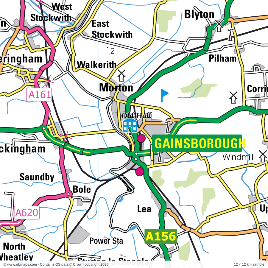
Gainsborough regional road map. Full 60 × 60 km PDF, SVG and Illustrator files, with a free PDF sample.

GBMAPS.COM

Gainsborough Regional Road Map

Call Us Now for Help01751 473136

GREAT BRITAIN ROAD ATLAS · 1:250,000 RY-41

Gainsborough & surrounding area

Explore the full 60 × 60 km Gainsborough regional road map at 1:250,000, covering Gainsborough, Retford, Scunthorpe, Worksop, Doncaster. Compare the complete coverage below; a detailed PDF sample is available free.

GAINSBOROUGH & SURROUNDING AREAREGIONAL ROAD MAP
60 × 60 km · Full map previewDownload the free SVG ↓

INSIDE THE FULL 60 × 60 KM MAP

Explore the Gainsborough map area

1:250,000 cartography

Towns, villages & places

More mapped places (296)
  • Saundby
  • Beckingham
  • Bole
  • Walkerith
  • Walkeringham
  • Lea
  • Misterton
  • Sturton le Steeple
  • Knaith
  • Corringham
  • Pilham
  • Clayworth
  • Upton
  • Springthorpe
  • Blyton
  • Aisby
  • Littleborough
  • Heapham
  • Wildsworth
  • Kexby
  • Wiseton
  • Gate Burton
  • Laughton
  • Graizelound
  • Hayton
  • Marton
  • Willingham by Stow
  • Clarborough
  • East Lound
  • Haxey
  • Cottam
  • Owston Ferry
  • Westwoodside
  • Treswell
  • Everton
  • Welham
  • Rampton
  • Mattersey
  • Brampton
  • Lound
  • Stow
  • Northorpe
  • Grove
  • Woodbeck
  • Torksey
  • Misson
  • Susworth
  • Scotton
  • Hemswell
  • Stokeham
  • Willoughton
  • Harpswell
  • Scaftworth
  • Laneham
  • Scotter
  • Blyborough
  • Headon
  • Scotterthorpe
  • Fenton
  • Laughterton
  • Ranskill
  • Torworth
  • Austerfield
  • Upton
  • Glentworth
  • Thorpe le Fallows
  • Scrooby
  • Babworth
  • Grayingham
  • Bransby
  • East Drayton
  • Kettlethorpe
  • Eaton
  • Fillingham
  • Wroot
  • Finningley
  • Askham
  • Ingham
  • Gamston
  • Blaxton
  • Ragnall
  • Beltoft
  • Cammeringham
  • Darlton
  • Belton
  • Broxholme
  • Saxilby
  • Messingham
  • Ranby
  • Brattleby
  • Bircotes
  • Thorney
  • Blyth
  • Aisthorpe
  • North Clifton
  • Manton
  • Elkesley
  • Broadholme
  • Markham Moor
  • Scampton
  • Atterby
  • Bishop Norton
  • Harworth
  • Auckley
  • Derrythorpe
  • Sandtoft
  • Snitterby
  • Milton
  • North Carlton
  • Waddingham
  • Styrrup
  • Hodsock
  • Scofton
  • Rossington
  • South Clifton
  • Althorpe
  • Burringham
  • Branton
  • Redbourne
  • Tuxford
  • Bevercotes
  • Glentham
  • South Carlton
  • Oldcotes
  • Harby
  • Wigsley
  • Bothamsall
  • Hackthorn
  • Spalford
  • Keadby
  • Haughton
  • Ealand
  • Langold
  • Spridlington
  • Gunness
  • Wigthorpe
  • Hibaldstow
  • Skellingthorpe
  • Egmanton
  • Grassthorpe
  • Weston
  • Doddington
  • Brandy Wharf
  • Walesby
  • Scawby
  • Armthorpe
  • Bishopbridge
  • Welton
  • Dunsville
  • Eagle Moor
  • Firbeck
  • Moorhouse
  • Hatfield
  • Letwell
  • Girton
  • Wadworth
  • Eagle
  • Loversall
  • Laxton
  • Perlethorpe
  • Dunscroft
  • Cold Hanworth
  • Toft next Newton
  • Edenthorpe
  • Dunholme
  • Gildingwells
  • Broughton
  • Amcotts
  • Newtoft
  • Boughton
  • Kirton
  • Stainton
  • Newton by Toft
  • Besthorpe
  • Nettleham
  • Cadney
  • Rhodesia
  • Ossington
  • Woodsetts
  • Kingerby
  • Shireoaks
  • Carburton
  • Santon
  • Wressle
  • Flixborough
  • Eastoft
  • North Owersby
  • West Rasen
  • Kirkby
  • Scothern
  • Thornton le Moor
  • Snarford
  • Luddington
  • Ollerton
  • North Kelsey
  • Budby
  • Stainforth
  • Faldingworth
  • Sudbrooke
  • Wellow
  • Braithwell
  • Ompton
  • Moorends
  • Kneesall
  • High Risby
  • Fishlake
  • Slade Hooton
  • Netherthorpe
  • Swinderby
  • Canwick
  • Arksey
  • Osgodby
  • Friesthorpe
  • Normanby
  • Low Risby
  • Collingham
  • Cromwell
  • Norwell
  • Howsham
  • Moortown
  • Sprotbrough
  • Micklebring
  • Clifton
  • Braithwaite
  • Reepham
  • Wrawby
  • Edwinstowe
  • Hodthorpe
  • Norton
  • Holton le Moor
  • Kersall
  • Washingborough
  • Snelland
  • Appleby
  • Haddington
  • Garthorpe
  • Hellaby
  • Roxby
  • Fockerby
  • Thealby
  • Langworth
  • Usselby
  • Wickenby
  • Aubourn
  • Whitwell
  • Cadeby
  • Holbeck
  • Thurlby
  • Cuckney
  • Maplebeck
  • Eakring
  • Fiskerton
  • Heighington
  • Fulnetby
  • Bigby
  • Coleby
  • Searby
  • Moss
  • Branston
  • Creswell
  • Sykehouse
  • Worlaby
  • Kings Clipstone
  • Grasby
  • Elsham
  • Marr
  • Bonby
  • Harmston
  • Bilsthorpe
  • Fenwick
  • Branston Booths
  • Askern
  • Sutton
  • Horkstow
  • Whaley
  • Elmton
  • Coleby
  • Clipstone
  • Brodsworth
  • Burghwallis
  • Potterhanworth
  • Langwith
  • Pollington
  • Campsall
  • Hampole
  • Norton
  • Balne
  • Nocton
  • Croxton
  • Burnham
  • Dunston
  • Wootton
  • Pleasley
  • Metheringham
  • Womersley
  • Blankney

Roads across this sheet

M18, M180, M181, A1(M), A15, A18, A19, A38, A46, A57, A60, A156, A158, A159, A161, A607, A614, A616, A617, A619, A620, A630, A631, A632

More road numbers

A634, A635, A638, A639, A1029, A1077, A1084, A1103, A1133, A1146, A1434, A1500, A6009, A6023, A6075, A6117, A6182, A6191, A6201, B1003, B1131, B1164, B1178, B1182, B1188, B1189, B1190, B1202, B1204, B1205, B1206, B1207, B1208, B1211, B1216, B1218, B1220, B1226, B1241, B1262, B1273, B1308, B1360, B1378, B1392, B1396, B1398, B1399, B1400, B1403, B1430, B1433, B1434, B1450, B1501, B6014, B6024, B6030, B6031, B6032, B6033, B6034, B6035, B6040, B6041, B6042, B6043, B6044, B6045, B6059, B6060, B6079, B6094, B6376, B6387, B6407, B6417, B6420, B6422, B6427, B6461, B6463

Rivers & waterways

Aire & Calder Navigation, CAR DYKE, Chesterfield Canal, Dutch River, Fossdyke Navigation, Fossdyke Navigation Canal, Land Drain, New Junction Canal, New River Ancholme, North Kelsey Beck, Old River Ancholme, River Ancholme

More waterways

River Brant, River Dearne, River Don, River Dun Navigation, River Eau, River Idle, River Maun, River Meden, River Poulter, River Ryton, River Till, River Torne, River Trent, River Went, River Witham, Sheffield & South Yorkshire Navigation, Stainforth & Keadby Canal

Landmarks & landscape

Amen Corner (Karting), Aston Pottery, Barlings Abbey, Barlings Abbey (remains of), Bassetlaw Museum & Percy Laws Memorial Gallery, Belton, Beth Shalom Holocaust Visitor Centre, Brandy Wharf Cider Centre, Bransby Home of Rest for Horses, Branston Solar Farm, Brodsworth Hall and Gardens, Brumby Common

More named features

Campsall Country Park, Clumber Park, Clumber Park & Visitor Centre, Conisbrough Castle, Conisbrough Castle and Visitor Centre, Creswell Crags Museum and Archaeology Park, Creswell Crags Visitor Centre, Cusworth Country Park, Daneshill Lakes Nature Reserve, Denaby Ings Nature Reserve, Doddington Hall, Doddington Hall and Garden, Doncaster Museum & Art Gallery, Doncaster Aeroventure, Doncaster Racecourse, Dukes Wood Oil Museum, Dyscarr Wood Nature Reserve, Eaton and Gamston Wood Nature Reserve, Ellis' Windmill, Elsham Hall Country Park, Epworth Old Rectory, Gainsborough Old Hall, Gainsthorpe Medieval Village, Hall Park Farm, Hartsholme Country Park, Haxey Nature Reserve, Haxey Reserve, Hemswell Craft and Design Centre, Hewitt's Windmill, Highfields Country Park, Idle Valley Nature Reserve, Johnstones Farm Centre, King's Wood, Kirton Pottery, Langold Country Park, Langwith Whaley Thorns Heritage Centre, Laxton Heritage Museum, Lincoln Bishop's Old Palace, Lincoln Castle, Lincoln Cathedral, Lincolnshire Agricultural Showground, Lincolnshire Road Transport Museum, Making It, Maltby Low Common, Mansfield Museum, Mattersey Priory, Meditation Centre and Japanese Garden, Melton Wood Country Park, Mount Pleasant Mill, Mr Straw's House, Museum Of Dolls & Bygone Childhood, Museum of Lincolnshire Life, New Lincoln City Museum, Museum of South Yorkshire Life, Normanby Hall, Normanby Hall Country Park, Normanby Park Fishing Museum, National Fishing Heritage Centre, Normanby Hall, North Leverton Windmill, North Lincs Museum, Owston Ferry The Old Smithy and Heritage Centre, Potteric Carr Nature Reserve, Poulter Country Park, Roche Abbey, Rufford Abbey, Rufford Country Park, Rufford Mill, Sandall Beat Wood Nature Reserve, Sandtoft Transport Centre, Sherwood Forest Art and Craft Centre, Sherwood Forest Country Park, Sherwood Forest Farm Park & Miniature Railway, Sherwood Heath Nature Reserve, Sherwood Pines Forest Park, Sherwood Pines Go Ape, Spalford Warren Nature Reserve, Sprotbrough Flash, Sundown Adventureland, Swanholme Lakes Nature Reserve, The Pink Pig, The Queen's Royal Lancers and Nott'shire Yeomanry Museum, The Walks Of Life Heritage Centre, Museum of the Horse, Thoresby Gallery, Thoresby Hall, Thorpe Marsh Nature Reserve, Treswell Wood Nature Reserve, Tropical Butterfly House and Wildlife Centre, Tuxford Windmill, Visitor Centre, Waddington Aircraft Viewing Enclosure, Welbeck Abbey, Wetlands Animal Park, Whisby Nature Park, Visitor Centre, Worksop Priory, Yorkshire Wildlife Centre
Local authority & parish coverage

Wholly or partly within the full map rectangle. These boundaries are coverage information, not additional artwork layers.

  • Ashfield DistrictPartly within
  • Bassetlaw DistrictWholly within
  • Bolsover DistrictPartly within
  • Doncaster DistrictPartly within
  • East Riding of YorkshirePartly within
  • Lincoln DistrictWholly within
  • Mansfield DistrictPartly within
  • Newark and Sherwood DistrictPartly within
  • North Kesteven DistrictPartly within
  • North LincolnshirePartly within
  • North YorkshirePartly within
  • Rotherham DistrictPartly within
  • Wakefield DistrictPartly within
  • West Lindsey DistrictPartly within
Wards & electoral divisions 175 areas
  • Abbey Ward
  • Ackworth, North Elmsall & Upton Ward (part)
  • Adwick le Street & Carcroft Ward
  • Anston & Woodsetts Ward (part)
  • Armthorpe Ward
  • Ashby Central Ward
  • Ashby Lakeside Ward
  • Aston & Todwick Ward (part)
  • Ault Hucknall Ward (part)
  • Axholme Central Ward
  • Axholme North Ward (part)
  • Axholme South Ward
  • Balby South Ward
  • Bancroft Ward
  • Bardney Ward (part)
  • Barton Ward (part)
  • Bassingham Rural Ward (part)
  • Beckingham Ward
  • Bentley Ward
  • Bessacarr Ward
  • Billinghay Rural Ward (part)
  • Bilsthorpe Ward (part)
  • Birchwood Ward
  • Blyth Ward
  • Bolsover East Ward (part)
  • Bottesford Ward
  • Boughton Ward
  • Boultham Ward
  • Bracebridge Heath Ward
  • Bramley & Ravenfield Ward (part)
  • Branston Ward (part)
  • Brick Kiln Ward
  • Brigg & Wolds Ward (part)
  • Broughton & Scawby Ward
  • Brumby Ward
  • Burringham & Gunness Ward
  • Burton upon Stather & Winterton Ward (part)
  • Caistor and Yarborough Ward (part)
  • Carholme Ward
  • Carlton Ward
  • Carr Bank Ward
  • Castle Ward
  • Central Ward
  • Cherry Willingham Ward
  • Clayworth Ward
  • Clowne East Ward (part)
  • Collingham Ward (part)
  • Conisbrough Ward (part)
  • Crosby & Park Ward
  • Dinnington Ward (part)
  • Dunholme and Welton Ward (part)
  • Eakring Ward
  • East Markham Ward
  • East Retford East Ward
  • East Retford North Ward
  • East Retford South Ward
  • East Retford West Ward
  • Edenthorpe & Kirk Sandall Ward
  • Edlington & Warmsworth Ward
  • Edwinstowe & Clipstone Ward
  • Elmton-with-Creswell Ward (part)
  • Everton Ward
  • Ferry Ward (part)
  • Finningley Ward
  • Frodingham Ward
  • Gainsborough East Ward
  • Gainsborough North Ward
  • Gainsborough South-West Ward
  • Glebe Ward
  • Grange Farm Ward (part)
  • Hartsholme Ward
  • Harworth Ward
  • Hatfield Ward
  • Heighington & Washingborough Ward
  • Hellaby & Maltby West Ward (part)
  • Hemswell Ward
  • Hexthorpe & Balby North Ward
  • Holly Forest Town Ward
  • Hornby Ward
  • Hykeham Central Ward
  • Hykeham Fosse Ward
  • Hykeham Memorial Ward
  • Kelsey Wold Ward (part)
  • Kings Walk Ward (part)
  • Kingsway Forest Town Ward
  • Kingsway with Lincoln Gardens Ward
  • Langold Ward
  • Langwith Ward (part)
  • Lea Ward
  • Ling Forest Ward (part)
  • Maltby East Ward
  • Manor Ward
  • Market Rasen Ward (part)
  • Market Warsop Ward
  • Maun Valley Forest Town Ward
  • Meden Ward
  • Messingham Ward
  • Metheringham Rural Ward (part)
  • Mexborough Ward (part)
  • Mill Lane Ward
  • Minster Ward
  • Misterton Ward
  • Moorland Ward
  • Muskham Ward (part)
  • Navenby & Brant Broughton Ward (part)
  • Netherfield Ward
  • Nettleham Ward
  • Newlands Forest Town Ward
  • Norton & Askern Ward
  • Oak Tree Ward (part)
  • Oakham Ward (part)
  • Ollerton Ward
  • Park Hall Ward
  • Park Ward
  • Penniment Ward
  • Pleasley Ward (part)
  • Pontefract South Ward (part)
  • Racecourse Ward
  • Rainworth North & Rufford Ward (part)
  • Rampton Ward
  • Ranskill Ward
  • Ridge Ward
  • Rock Hill Ward
  • Roman Ridge Ward
  • Rossington & Bawtry Ward
  • Rufford Ward
  • Saxilby Ward
  • Scampton Ward
  • Scotter and Blyton Ward
  • Sherwood Ward
  • Shirebrook North Ward
  • Shirebrook South Ward
  • Skegby Ward (part)
  • Skellingthorpe & Eagle Ward
  • Snaith, Airmyn, Rawcliffe and Marshland Ward (part)
  • Southwell Ward (part)
  • Southwell Ward (part)
  • Sprotbrough Ward (part)
  • Stainforth & Barnby Dun Ward
  • Stow Ward
  • Sturton Ward
  • Sudbrooke Ward
  • Sutton Central & New Cross Ward (part)
  • Sutton Ward
  • Sutton-on-Trent Ward (part)
  • The Dales Ward (part)
  • Thompsons Ward (part)
  • Thorne & Moorends Ward
  • Thurcroft & Wickersley South Ward (part)
  • Tickhill & Wadsworth Ward (part)
  • Torksey Ward
  • Town Ward
  • Town Ward
  • Tuxford and Trent Ward
  • Vale Ward
  • Waddingham and Spital Ward
  • Waddington Rural Ward (part)
  • Wainwright Ward
  • Wales Ward (part)
  • Warsop Carrs Ward
  • Welbeck Ward
  • West Bank Ward
  • Wheatley Hills & Intake Ward
  • Whitwell Ward (part)
  • Witham St. Hughs & Swinderby Ward
  • Witham Ward
  • Wold View Ward (part)
  • Worksop East Ward
  • Worksop North East Ward
  • Worksop North Ward
  • Worksop North West Ward
  • Worksop South East Ward
  • Worksop South Ward
  • Yeoman Hill Ward
  • Osgoldcross ED (part)
Civil parishes & communities 376 areas
  • Aisthorpe CP
  • Alkborough CP (part)
  • Amcotts CP
  • Apley CP (part)
  • Appleby CP
  • Armthorpe CP
  • Ashby Parkland CP
  • Askern CP
  • Askham CP
  • Aubourn with Haddington CP
  • Auckley CP
  • Austerfield CP
  • Babworth CP
  • Balne CP (part)
  • Barlings CP
  • Barnburgh CP (part)
  • Barnby Dun with Kirk Sandall CP
  • Barnby Moor CP
  • Barnetby Le Wold CP
  • Barrow upon Humber CP (part)
  • Barton CP (part)
  • Bassingham CP (part)
  • Bathley CP (part)
  • Bawtry CP
  • Beckingham CP
  • Belton CP
  • Besthorpe CP
  • Bevercotes CP
  • Bigby CP
  • Bilsthorpe CP (part)
  • Bishop Norton CP
  • Blankney CP (part)
  • Blaxton CP
  • Blyborough CP
  • Blyth CP
  • Blyton CP
  • Bole CP
  • Bonby CP
  • Boothby Graffoe CP (part)
  • Bothamsall CP
  • Bottesford CP
  • Bracebridge Heath CP
  • Braithwell CP (part)
  • Bramley CP (part)
  • Brampton CP
  • Branston and Mere CP (part)
  • Brattleby CP
  • Brigg CP
  • Broadholme CP
  • Brodsworth CP (part)
  • Broughton CP
  • Broxholme CP
  • Bullington CP (part)
  • Burghwallis CP
  • Burringham CP
  • Burton CP
  • Burton upon Stather CP
  • Buslingthorpe CP
  • Cadeby CP
  • Cadney CP
  • Caenby CP
  • Caistor CP (part)
  • Cammeringham CP
  • Cantley CP
  • Canwick CP
  • Carburton CP
  • Carlton in Lindrick CP
  • Carlton-on-Trent CP
  • Caunton CP (part)
  • Cherry Willingham CP
  • Clarborough and Welham CP
  • Claxby CP (part)
  • Clayworth CP
  • Clipstone CP
  • Clowne CP (part)
  • Clumber and Hardwick CP
  • Cold Hanworth CP
  • Coleby CP (part)
  • Collingham CP (part)
  • Conisbrough Parks CP (part)
  • Corringham CP
  • Cottam CP
  • Cromwell CP
  • Crowle and Ealand CP
  • Croxton CP (part)
  • Darlton CP
  • Darrington CP (part)
  • Dinnington St. John's CP (part)
  • Doddington and Whisby CP
  • Dunham-on-Trent CP
  • Dunholme CP
  • Dunston CP (part)
  • Eagle and Swinethorpe CP
  • Eakring CP
  • East Butterwick CP
  • East Drayton CP
  • East Ferry CP
  • East Markham CP
  • East Stockwith CP
  • Eastoft CP
  • Eaton CP
  • Edenthorpe CP
  • Edlington CP
  • Edwinstowe CP
  • Egmanton CP
  • Elkesley CP
  • Elmton with Creswell CP (part)
  • Elsham CP
  • Epworth CP
  • Everton CP
  • Faldingworth CP
  • Fenton CP
  • Fenwick CP
  • Fillingham CP
  • Finningley CP
  • Firbeck CP
  • Fishlake CP
  • Fiskerton CP
  • Fledborough CP
  • Flixborough CP
  • Friesthorpe CP
  • Fulnetby CP (part)
  • Gainsborough CP
  • Gamston CP
  • Garthorpe and Fockerby CP (part)
  • Gate Burton CP
  • Gildingwells CP
  • Girton CP
  • Glentham CP
  • Glentworth CP
  • Goole Fields CP (part)
  • Goxhill CP (part)
  • Grange De Lings CP
  • Grasby CP (part)
  • Grassthorpe CP
  • Grayingham CP
  • Great Limber CP (part)
  • Greetwell CP
  • Gringley on the Hill CP
  • Grove CP
  • Gunness CP
  • Hackthorn CP
  • Hampole CP (part)
  • Harby CP
  • Hardwick CP
  • Harmston CP
  • Harpswell CP
  • Harthill with Woodall CP (part)
  • Harworth Bircotes CP
  • Hatfield CP
  • Haughton CP
  • Haxey CP
  • Hayton CP
  • Headon cum Upton CP
  • Heapham CP
  • Heck CP (part)
  • Heighington CP
  • Hellaby CP (part)
  • Hemswell CP
  • Hemswell Cliff CP
  • Hibaldstow CP
  • Hickleton CP (part)
  • High Melton CP (part)
  • Hockerton CP (part)
  • Hodsock CP
  • Hodthorpe and Belph CP
  • Holme CP (part)
  • Holton Le Moor CP
  • Hooton Levitt CP
  • Horkstow CP
  • Ingham CP
  • Keadby with Althorpe CP
  • Kersall CP
  • Kettlethorpe CP
  • Kexby CP
  • Kings Clipstone CP
  • Kirk Bramwith CP
  • Kirk Smeaton CP (part)
  • Kirklington CP (part)
  • Kirmington CP (part)
  • Kirton CP
  • Kirton in Lindsey CP
  • Knaith CP
  • Kneesall CP
  • Laneham CP
  • Langford CP (part)
  • Langwith CP (part)
  • Laughton CP
  • Laughton-en-le-Morthen CP (part)
  • Laxton and Moorhouse CP
  • Lea CP
  • Letwell CP
  • Linwood CP (part)
  • Lissington CP (part)
  • Little Smeaton CP
  • Lound CP
  • Loversall CP
  • Luddington and Haldenby CP
  • Maltby CP
  • Manton CP
  • Maplebeck CP (part)
  • Market Rasen CP (part)
  • Marnham CP
  • Marr CP (part)
  • Martin CP (part)
  • Marton CP
  • Mattersey CP
  • Meering CP
  • Melton Ross CP
  • Messingham CP
  • Metheringham CP (part)
  • Middle Rasen CP (part)
  • Misson CP
  • Misterton CP
  • Morton CP
  • Moss CP
  • Nether Langwith CP
  • Nettleham CP
  • Nettleton CP (part)
  • Newball CP
  • Newton on Trent CP
  • Nocton CP (part)
  • Normanby By Spital CP
  • Normanton on Trent CP
  • North Carlton CP
  • North Clifton CP
  • North Hykeham CP
  • North Kelsey CP
  • North Leverton with Habblesthorpe CP
  • North Muskham CP (part)
  • North Scarle CP
  • North and South Anston CP (part)
  • North and South Wheatley CP
  • Northorpe CP
  • Norton CP
  • Norton Disney CP (part)
  • Norton, Cuckney, Holbeck and Welbeck CP
  • Norwell CP
  • Old Bolsover CP (part)
  • Ollerton and Boughton CP
  • Ompton CP
  • Osgodby CP (part)
  • Ossington CP
  • Owersby CP
  • Owmby-by-Spital CP
  • Owston CP
  • Owston Ferry CP
  • Perlethorpe cum Budby CP
  • Pilham CP
  • Pleasley CP (part)
  • Pollington CP (part)
  • Potter Hanworth CP (part)
  • Ragnall CP
  • Rainworth CP (part)
  • Rampton and Woodbeck CP
  • Rand CP (part)
  • Ranskill CP
  • Ravenfield CP (part)
  • Rawcliffe CP (part)
  • Redbourne CP
  • Reedness CP (part)
  • Reepham CP
  • Rhodesia CP
  • Riseholme CP
  • Rossington CP
  • Roxby cum Risby CP
  • Rufford CP (part)
  • Saundby CP
  • Saxby All Saints CP
  • Saxby CP
  • Saxilby with Ingleby CP
  • Scaftworth CP
  • Scampton CP
  • Scarcliffe CP (part)
  • Scawby CP
  • Scothern CP
  • Scotter CP
  • Scotton CP
  • Scrooby CP
  • Searby cum Owmby CP (part)
  • Shirebrook CP
  • Shireoaks CP
  • Skellingthorpe CP
  • Snaith and Cowick CP (part)
  • Snarford CP
  • Snelland CP
  • Snitterby CP
  • Somerby CP
  • South Carlton CP
  • South Clifton CP
  • South Ferriby CP (part)
  • South Hykeham CP
  • South Kelsey CP
  • South Leverton CP
  • South Scarle CP
  • Spalford CP
  • Spridlington CP
  • Springthorpe CP
  • Sprotbrough and Cusworth CP
  • Stainfield CP (part)
  • Stainforth CP
  • Stainton By Langworth CP
  • Stainton CP
  • Stapleton CP (part)
  • Stokeham CP
  • Stow CP
  • Stubbs Walden CP
  • Sturton By Stow CP
  • Sturton Le Steeple CP
  • Styrrup with Oldcotes CP
  • Sudbrooke CP
  • Sutton CP
  • Sutton-on-Trent CP
  • Swinderby CP
  • Swinefleet CP (part)
  • Sykehouse CP
  • Thonock CP
  • Thorne CP
  • Thorney CP
  • Thornton Curtis CP (part)
  • Thorpe Salvin CP
  • Thorpe in Balne CP
  • Thorpe in the Fallows CP
  • Thorpe on the Hill CP
  • Thurcroft CP (part)
  • Thurlby CP
  • Tickhill CP
  • Todwick CP (part)
  • Toft Newton CP
  • Torksey CP
  • Torworth CP
  • Treswell CP
  • Tuxford CP
  • Twin Rivers CP (part)
  • Ulceby CP (part)
  • Upton CP
  • Upton and North Elmsall CP (part)
  • Waddingham CP
  • Waddington CP
  • Wadworth CP
  • Wales CP (part)
  • Walesby CP
  • Walkeringham CP
  • Walkerith CP
  • Wallingwells CP
  • Warmsworth CP
  • Warsop CP
  • Washingborough CP
  • Wellow CP
  • Welton CP
  • West Burton CP
  • West Butterwick CP
  • West Drayton CP
  • West Firsby CP
  • West Halton CP (part)
  • West Markham CP
  • West Rasen CP
  • West Stockwith CP
  • Weston CP
  • Whitley CP (part)
  • Whitwell CP (part)
  • Wickenby CP (part)
  • Wigsley CP
  • Wildsworth CP
  • Willingham CP
  • Willoughton CP
  • Winkburn CP (part)
  • Winterton CP (part)
  • Wiseton CP
  • Witham St. Hughs CP
  • Womersley CP (part)
  • Woodsetts CP
  • Wootton CP
  • Worlaby CP
  • Wrawby CP
  • Wroot CP

Source: the GBMaps road atlas, OS Boundary-Line and postcode mapping datasets. Source editions are being checked for publication. Unmarked boundary names are wholly within the sheet; “part” means the map edge crosses the area.

Place lists are selected from the map source, not a complete gazetteer. Named features describe the cartography; visitor facilities and opening status are not verified. The free sample covers only 12 × 12 km of this larger sheet.

INSIDE YOUR DOWNLOAD

A proper road map, in useful formats

Road classifications, towns and villages, railways, rivers, landscape detail and tourist symbols, brought together in the GBMaps regional road atlas style.

PDF filePDFSVG fileSVGAdobe Illustrator AI fileAi

PDF for the finished map. SVG and layered Illustrator artwork for adapting colours, adding your own information and preparing designs.

THE FINISHED SHEET

Designed for print and presentation

Map coverage
60 × 60 km
Sample coverage
12 × 12 km
Print layout
A3 landscape · enlarged 1:250k cartography
Sheet furniture
Border, scale bar, key & north arrow

A few useful details

What changes when I select another square?

Select a surrounding square to bring it into the centre and reveal the maps around it. Each square is a different 60 × 60 km map. The preview, free sample and selected download change together. Neighbouring sheets overlap by 30 km so you can choose the coverage that suits you.

Is the free sample a vector map?

The on-page detail is an SVG. The free download is a separate 12 × 12 km PDF with a link to the full map. Please retain its copyright credits and product link when sharing it.

Can I buy a larger combined map?

These downloads are individual ready-made sheets. Contact GBMaps if you need a larger combined area.

FREE PDF SAMPLE

Your free map sample

Your free 12 × 12 km sample includes a link back to this map, so you can return for the full area whenever you need it.

Download free PDF sample ↓

Get your Gainsborough map

Map download bundle

£24.00including VATOne payment

Pay securely

One payment. Your map stays open.

Your map download

Your map files

Preparing your download…

Checking your private download link…

Your map downloads

Already bought a map?

Find the downloads from your purchases.

Enter the email address you used at checkout. We’ll email you a private link to your available map downloads.