Dundee regional road map. Full 60 × 60 km PDF, SVG and Illustrator files, with a free PDF sample.

GBMAPS.COM

Dundee Regional Road Map

Call Us Now for Help01751 473136

GREAT BRITAIN ROAD ATLAS · 1:250,000 GB-330-0720

Dundee & surrounding area

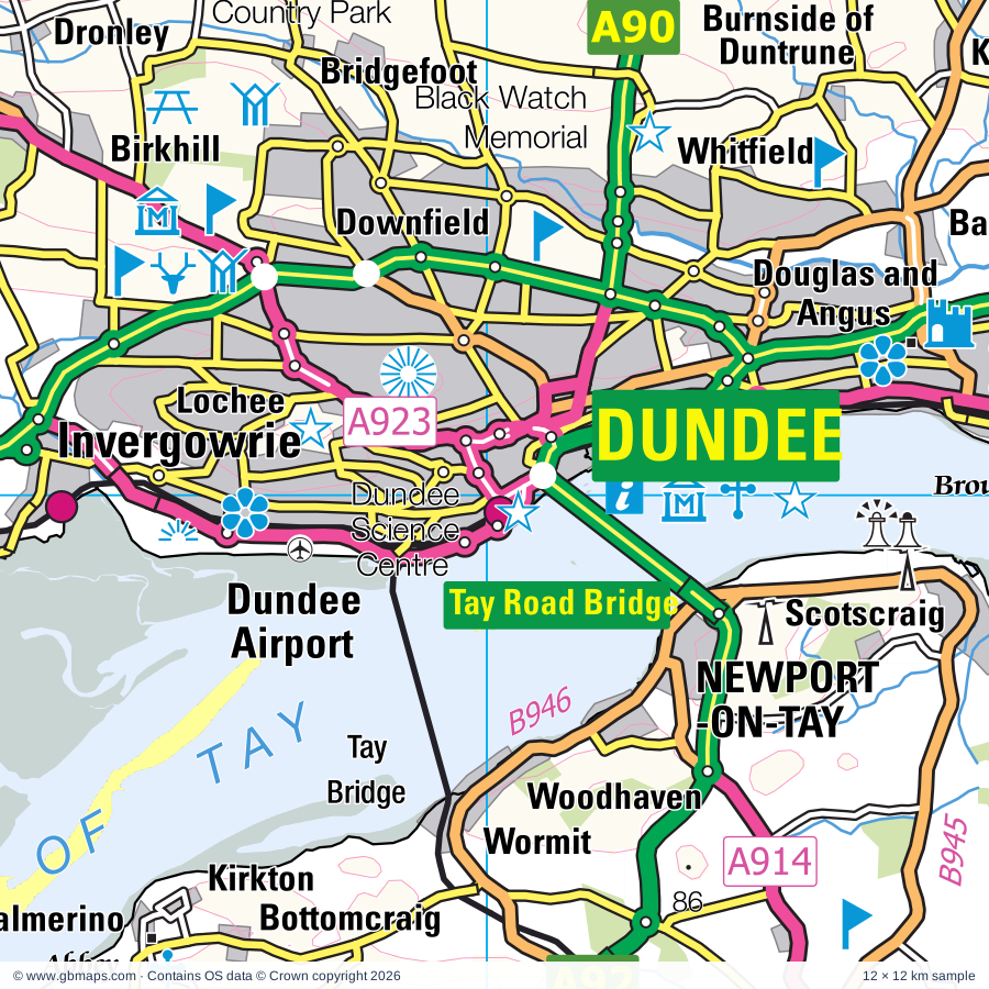
Explore the full 60 × 60 km Dundee regional road map at 1:250,000, covering Dundee, Perth, Newburgh, Cupar, Auchtermuchty. Compare the complete coverage below; a detailed PDF sample is available free.

DUNDEE & SURROUNDING AREAREGIONAL ROAD MAP
60 × 60 km · Full map previewDownload the free SVG ↓

INSIDE THE FULL 60 × 60 KM MAP

Explore the Dundee map area

1:250,000 cartography

Towns, villages & places

More mapped places (236)
  • Alyth
  • Carnoustie
  • Pittenweem
  • Cowdenbeath
  • Brunton
  • Dunbog
  • Luthrie
  • Creich
  • Lindores
  • Errol
  • Letham
  • Moonzie
  • Grange of Lindores
  • Monimail
  • Rathillet
  • Grange
  • Collessie
  • Balmerino
  • Kinloch
  • Kirkton
  • Bottomcraig
  • Foodieash
  • Gauldry
  • Leetown
  • Kilmany
  • Giffordtown
  • Inchture
  • Springfield
  • Chapelhill
  • Cottown
  • Kilspindie
  • Rait
  • Kinnaird
  • Kingoodie
  • Longforgan
  • Ballindean
  • Glencarse
  • Logie
  • Craigdallie
  • St Madoes
  • Pitlessie
  • Dunshalt
  • Invergowrie
  • Knapp
  • Abernethy
  • Inchyra
  • Balmalcolm
  • Kingskettle
  • Osnaburgh
  • Abernyte
  • Craigrothie
  • Kettlebridge
  • Kemback
  • Kettlehill
  • Balmullo
  • Lucklawhill
  • Glenfoot
  • Strathmiglo
  • Ceres
  • Freuchie
  • Fowlis
  • Pitscottie
  • Liff
  • Blebocraigs
  • Rhynd
  • Pickletillum
  • St Michaels
  • Aberargie
  • Muirhead
  • Muirhead
  • Guardbridge
  • Birkhill
  • Kinfauns
  • Baldinnie
  • Leuchars
  • Collace
  • Balbeggie
  • Gateside
  • Dronley
  • Kincaple
  • Strathkinness
  • Dron
  • Lundie
  • Kinrossie
  • Saucher
  • Star
  • Bridge of Earn
  • Woodside
  • Bridgefoot
  • Scone
  • Tarsappie
  • Bonnybank
  • New Gilston
  • Auchterhouse
  • Denhead
  • St Martins
  • Burnside
  • Kennoway
  • Leys
  • Craigend
  • Peat Inn
  • Glenfarg
  • Lawhead
  • Radernie
  • Campmuir
  • Duncrievie
  • Burrelton
  • Wolfhill
  • Windygates
  • Kettins
  • Woodside
  • Markethill
  • Auchmuirbridge
  • Upper Largo
  • Guildtown
  • Kirkton of Tealing
  • Largoward
  • Inveraldie
  • Lathones
  • Kinnesswood
  • Lower Largo
  • Newtyle
  • Tealing
  • Forgandenny
  • Stormontfield
  • Scotlandwell
  • Middleton
  • Drumeldrie
  • Aberdalgie
  • Kellas
  • Ardler
  • Thornton
  • Ruthvenfield
  • Cargill
  • Kinglassie
  • Luncarty
  • Redgorton
  • Stanley
  • Huntingtower
  • Drumsturdy
  • Milnathort
  • Kinclaven
  • Arthurstone
  • Wellbank
  • Kirkinch
  • Colinsburgh
  • Meikleour
  • Almondbank
  • Meigle
  • Pitcairngreen
  • Balkeerie
  • Tibbermore
  • Forteviot
  • Stravithie
  • Cluny
  • Moneydie
  • Dunino
  • Airntully
  • Ballingry
  • Auchterderran
  • Newbigging
  • Stronachie
  • Kilconquhar
  • Carsie
  • Cardenden
  • Arncroach
  • Crosshill
  • Carnbee
  • Charleston
  • Gairney Bank
  • Monikie
  • Earlsferry
  • Boarhills
  • Murthly
  • Eassie
  • Elie
  • Barry
  • Abercrombie
  • Bankfoot
  • Gellyburn
  • New Alyth
  • Gateside
  • Craigton
  • Glamis
  • Methven
  • Spittalfield
  • Dunning
  • Inverarity
  • Ruthven
  • St Monans
  • Caputh
  • Kirkton
  • Kinloch
  • Waterloo
  • Douglastown
  • Craigie
  • Carnbo
  • Coldrain
  • Dalreoch
  • Cleish
  • Kelty
  • Whigstreet
  • Auchtertool
  • Clunie
  • Kingsbarns
  • Chapelhill
  • Kirkbuddo
  • Kilrenny
  • Muirdrum
  • Drum
  • Forneth
  • Greystone
  • Tulloes
  • East Haven
  • Caldhame
  • Lownie Moor
  • Craichie
  • Carmyllie
  • Birnam
  • Kingsmuir
  • Kingseat
  • Rumbling Bridge
  • Little Dunkeld
  • Butterstone
  • Bowershall
  • Dunnichen
  • Powmill
  • Dunkeld
  • Redford
  • Inver
  • Letham
  • Saline
  • Cowstrandburn
  • Dowally
  • Guay
  • Friockheim

Roads across this sheet

M90, A85, A91, A92, A93, A94, A822, A823, A907, A909, A910, A911, A912, A913, A914, A915, A916, A917, A918, A919, A921, A922, A923, A926

More road numbers

A928, A929, A930, A932, A933, A955, A972, A977, A984, A989, A991, B867, B898, B912, B913, B914, B915, B917, B918, B919, B920, B921, B922, B925, B927, B928, B929, B930, B931, B932, B933, B934, B935, B936, B937, B938, B939, B940, B941, B942, B944, B945, B946, B947, B948, B949, B952, B953, B954, B959, B960, B961, B962, B965, B969, B978, B981, B995, B996, B8062, B8063, B9097, B9099, B9112, B9127, B9128, B9129, B9130, B9131, B9141, B9149, B9157, B9171

Rivers & waterways

Cameron Burn, Dean Water, Dighty Water, Elliot Water, Lornty Burn, Lunan Burn, Lunan Water, Monikie Burn, Ordie Burn, Pow Water, River Almond, River Braan

More waterways

River Devon, River Earn, River Eden, River Ericht, River Isla, River Leven, River Ore, River Tay, Shochie Burn, South Queich, Water of May

Landmarks & landscape

Abbey, Abernethy Round Tower, Active Kid Toys and Adventure Park, Affleck Castle, Alyth Folk Museum, Angus Folk Museum, Ardestie Earth House, Ardestie Souterrain, Balbirnie Craft Centre, Balcarres House Gardens, Balgonie Castle, Balmerino Abbey, TAY FOREST PARK

More named features

Balvaird Castle, Barnhill Rock Garden, Barry Mill, Belmont Castle, Birnie Loch Nature Reserve, Black Watch Memorial, Branklyn Garden, British Golf Museum, St Andrews Museum, St Andrews Preservation Trust, Museum of the University of St Andrews, Broughty Castle, Broughty Castle Museum, Buckhaven Museum, Bunnet Stane Unusual rock formation, Burleigh Castle, Cairn O'Mohr Winery, Camperdown House, Camperdown Park, Camperdown Wildlife Centre, Cardney House, Carlungie Earth House, Carlungie Souterrain, Castle, Castle Huntly, Cheese Company, City of Perth Art Gallery and Museum, The Black Watch Museum, Clatto Country Park, Claypotts Castle, Cluny Clays Activity Centre, Craigluscar Reservoir Nature Reserve, Craigtoun Country Park, Crombie Country Park, Cruivie Castle, Discovery Point, Bonar Hall Arts Centre, Dundee Science Centre, Dogton Stone Cross, Dunkeld Cathedral, Dunkeld Cathedral Chapter House Museum, Duntrune Demonstration Garden, Dupplin Castle, Eassie Sculptured Stone, Eden Estuary Centre, Eden Estuary Nature Reserve, Elcho Castle, Ethiebeaton Park Visitor Centre, Falkland Palace, Fife Animal Park, Fife Folk Museum, Fife Mining Museum, Fife Regional Park, Fingask Castle, Glamis Castle, Glentarkie Motor Racing Circuit, Griselda Hill Pottery, HM Frigate Unicorn, Verdant Works, Dundee Contempory Arts, Sensation Dundee, Hallyburton House, Hill of Tarvit Mansionhouse, Hill of Tarvit Mansionhouse and Garden, Huntingtower Castle, John McDouall Stuart Museum, Kartstart Indoor Raceway, Kellie Castle and Garden, Kinross Museum, Kirkcaldy Museum and Art Gallery, Knockhill Motor Racing Circuit, Lindores Abbey, Loch Leven National Nature Reserve, Loch of Lowes Nature Reserve, Loch of Lowes Visitor Centre, Lochleven Castle, Lochore Meadows Country Park, Macduff's Castle, Mc Manus Galleries, Dundee Museum of Transport, Meigle Sculptured Stones Museum, Meikleour Beech Hedge, Methil Heritage Centre, Mills Observatory, Monikie Country Park, Museum of Abernethy, Newburgh Bear, Palace, Perth Racecourse, Perthshire Visitor Centre, Pitmuies Garden, Priory, Quarrymill Woodland Park, Ravenscraig Castle, Riemore Lodge, Rossie Priory, Ruthven House, Scone Palace, Scone Palace Gardens, Scotland Secret Bunker, Scotlandwell, Scotstarvit Tower, Scotstarvit Tower, Barbarafield Riding School, Scottish Deer Centre, Scottish Fisheries Museum, Scottish Vintage Bus Museum, Silverburn House and Park, Snaigow House, St Andrews Aquarium, St Andrews Botanic Garden, St Andrews Castle, St Andrews Cathedral, St Andrews Cathedral, St Pauls Cathedral, St Monans Windmill, St Ninian's Cathedral, St Serf's Church & Dupplin Cross, Stanley Mills, Stewart Tower Dairy, Stormont Loch Nature Reserve, Tealing Earth House (Souterrain), Tentsmuir Point Nature Reserve, The Balado Activity Centre, The Hermitage, Tower, Tullibole Castle, University (of Dundee) Botanic Garden, Vane Farm Nature Reserve Visitor Centre, Vane Farm RSPB Reserve, Visitor Centre, West Port, Blackfriars Chapel, St Mary on the Rock, St Rule's Tower, St Andrews Precinct Wall and Pends
Local authority & parish coverage

Wholly or partly within the full map rectangle. These boundaries are coverage information, not additional artwork layers.

  • AngusPartly within
  • ClackmannanshirePartly within
  • Dundee CityWholly within
  • FifePartly within
  • Perth and KinrossPartly within
Wards & electoral divisions 42 areas
  • Almond and Earn Ward (part)
  • Arbroath West, Letham and Friockheim Ward (part)
  • Blairgowrie and Glens Ward (part)
  • Buckhaven, Methil and Wemyss Villages Ward
  • Burntisland, Kinghorn and Western Kirkcaldy Ward (part)
  • Carnoustie and District Ward (part)
  • Carse of Gowrie Ward
  • Clackmannanshire East Ward (part)
  • Coldside Ward
  • Cowdenbeath Ward (part)
  • Cupar Ward
  • Dunfermline North Ward (part)
  • East End Ward
  • East Neuk and Landward Ward (part)
  • Forfar and District Ward (part)
  • Glenrothes Central and Thornton Ward
  • Glenrothes North, Leslie and Markinch Ward
  • Glenrothes West and Kinglassie Ward
  • Howe of Fife and Tay Coast Ward
  • Kinross-shire Ward (part)
  • Kirkcaldy Central Ward
  • Kirkcaldy East Ward
  • Kirkcaldy North Ward
  • Kirriemuir and Dean Ward (part)
  • Leven, Kennoway and Largo Ward
  • Lochee Ward
  • Lochgelly, Cardenden and Benarty Ward
  • Maryfield Ward
  • Monifieth and Sidlaw Ward
  • North East Ward
  • Perth City Centre Ward
  • Perth City North Ward
  • Perth City South Ward
  • St. Andrews Ward
  • Strathallan Ward (part)
  • Strathmartine Ward
  • Strathmore Ward (part)
  • Strathtay Ward (part)
  • Tay Bridgehead Ward
  • The Ferry Ward
  • West End Ward
  • West Fife and Coastal Villages Ward (part)
Civil parishes & communities 0 areas

    Source: the GBMaps road atlas, OS Boundary-Line and postcode mapping datasets. Source editions are being checked for publication. Unmarked boundary names are wholly within the sheet; “part” means the map edge crosses the area.

    Place lists are selected from the map source, not a complete gazetteer. Named features describe the cartography; visitor facilities and opening status are not verified. The free sample covers only 12 × 12 km of this larger sheet.

    INSIDE YOUR DOWNLOAD

    A proper road map, in useful formats

    Road classifications, towns and villages, railways, rivers, landscape detail and tourist symbols, brought together in the GBMaps regional road atlas style.

    PDF filePDFSVG fileSVGAdobe Illustrator AI fileAi

    PDF for the finished map. SVG and layered Illustrator artwork for adapting colours, adding your own information and preparing designs.

    THE FINISHED SHEET

    Designed for print and presentation

    Map coverage
    60 × 60 km
    Sample coverage
    12 × 12 km
    Print layout
    A3 landscape · enlarged 1:250k cartography
    Sheet furniture
    Border, scale bar, key & north arrow

    A few useful details

    What changes when I select another square?

    Select a surrounding square to bring it into the centre and reveal the maps around it. Each square is a different 60 × 60 km map. The preview, free sample and selected download change together. Neighbouring sheets overlap by 30 km so you can choose the coverage that suits you.

    Is the free sample a vector map?

    The on-page detail is an SVG. The free download is a separate 12 × 12 km PDF with a link to the full map. Please retain its copyright credits and product link when sharing it.

    Can I buy a larger combined map?

    These downloads are individual ready-made sheets. Contact GBMaps if you need a larger combined area.

    FREE PDF SAMPLE

    Your free map sample

    Your free 12 × 12 km sample includes a link back to this map, so you can return for the full area whenever you need it.

    Download free PDF sample ↓

    Get your Dundee map

    Map download bundle

    £24.00including VATOne payment

    Pay securely

    One payment. Your map stays open.

    Your map download

    Your map files

    Preparing your download…

    Checking your private download link…

    Your map downloads

    Already bought a map?

    Find the downloads from your purchases.

    Enter the email address you used at checkout. We’ll email you a private link to your available map downloads.