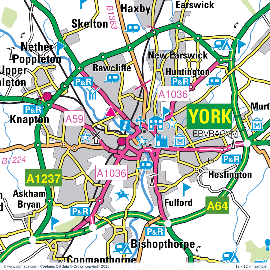
Explore the full 60 × 60 km York regional road map at 1:250,000, covering Harrogate, Ripon, Wetherby, Leeds, Selby and the surrounding towns and countryside. Compare the complete coverage below, with a detailed York PDF sample available free.
YORK & SURROUNDING AREA VECTOR ROAD MAPREGIONAL ROAD MAP
York and the surrounding road network, from Ripon and Harrogate to Malton, with Leeds, Castleford, Selby and Goole towards the southern edge. The full sheet brings together motorway connections, A-roads, smaller settlements, rivers and named visitor landmarks.
Snaith, Airmyn, Rawcliffe and Marshland Ward (part)
Sowerby & Topcliffe ED (part)
Spofforth with Lower Wharfedale & Tockwith ED
Stanley & Outwood East Ward
Stray, Woodlands & Hookstone ED
Strensall Ward
Tadcaster ED
Temple Newsam Ward
Thirsk ED (part)
Thornton Dale & Wolds ED (part)
Thorpe Willoughby & Hambleton ED
Valley Gardens & Central Harrogate ED
Wakefield East Ward (part)
Wakefield North Ward
Wakefield West Ward (part)
Washburn & Birstwith ED (part)
Wathvale & Bishop Monkton ED (part)
Weetwood Ward
Westfield Ward
Wetherby Ward
Wheldrake Ward
Wolds Weighton Ward (part)
Wrenthorpe & Outwood West Ward
Civil parishes 429 · 342 wholly, 87 partly
Aberford CP
Acaster Malbis CP
Acaster Selby CP
Acklam CP (part)
Ainderby Quernhow CP (part)
Airmyn CP
Aldfield CP
Aldwark CP
Allerthorpe CP
Allerton Bywater CP
Allerton Mauleverer with Hopperton CP
Alne CP
Alwoodley CP
Amotherby CP
Ampleforth CP (part)
Angram Grange CP
Appleton Roebuck CP
Appleton-le-Street with Easthorpe CP
Arkendale CP
Arthington CP
Asenby CP
Askham Bryan CP
Askham Richard CP
Asselby CP
Austhorpe CP
Azerley CP
Bagby CP (part)
Baldersby CP (part)
Balk CP (part)
Balne CP (part)
Bardsey cum Rigton CP
Barkston Ash CP
Barlby with Osgodby CP
Barlow CP
Barmby Moor CP (part)
Barmby on the Marsh CP
Barton-le-Street CP
Barton-le-Willows CP
Barugh (Great and Little) CP (part)
Barwick in Elmet and Scholes CP
Beal CP
Beckwithshaw CP
Beningbrough CP
Bielby CP (part)
Biggin CP
Bilbrough CP
Bilton-in-Ainsty with Bickerton CP
Birdforth CP
Birdsall CP (part)
Birkin CP
Birstwith CP
Bishop Monkton CP
Bishop Thornton, Shaw Mills and Warsill CP
Bishop Wilton CP (part)
Bishopthorpe CP
Bolton Percy CP
Boroughbridge CP
Boston Spa CP
Brafferton and Helperby CP
Bramham cum Oglethorpe CP
Bramhope CP
Brandsby-cum-Stearsby CP
Brawby CP (part)
Brayton CP
Brearton CP
Bridge Hewick CP
Brotherton CP
Broughton CP
Bubwith CP
Bugthorpe CP
Bulmer CP
Burn CP
Burton Leonard CP
Burton Salmon CP
Burton-on-Yore CP (part)
Burythorpe CP (part)
Buttercrambe with Bossall CP
Byland with Wass CP (part)
Byram cum Sutton CP
Camblesforth CP
Carlton CP
Carlton CP
Carlton Husthwaite CP
Carlton Miniott CP (part)
Castley CP
Cattal CP
Catterton CP
Catton CP
Catton CP
Cawood CP
Cawton CP
Chapel Haddlesey CP
Church Fenton CP
Claxton CP
Cliffe CP
Clifford CP
Clifton Without CP
Clint cum Hamlets CP
Collingham CP
Colton CP
Coneysthorpe CP
Coneythorpe and Clareton CP
Copgrove CP
Copmanthorpe CP
Copt Hewick CP
Cottingwith CP
Coulton CP
Coxwold CP
Crambe CP
Crayke CP
Cridling Stubbs CP
Cundall with Leckby CP
Dacre CP (part)
Dalby-cum-Skewsby CP
Dalton CP
Darley and Menwith CP (part)
Darrington CP (part)
Deighton CP
Dishforth CP
Drax CP
Drighlington CP
Dunnington CP
Dunsforths CP
Earswick CP
Easingwold CP
East Keswick CP
East Tanfield CP (part)
Eastrington CP (part)
Eavestone CP (part)
Eggborough CP
Eldmire with Crakehill CP
Ellenthorpe CP
Ellerton CP
Elvington CP
Escrick CP
Everingham CP (part)
Fairburn CP
Fangfoss CP
Farlington CP
Farnham CP
Farnley CP (part)
Fawdington CP
Featherstone CP (part)
Felliscliffe CP
Ferrensby CP
Fewston CP (part)
Flawith CP
Flaxby CP
Flaxton CP
Foggathorpe CP
Follifoot CP
Foston CP
Fryton CP
Fulford CP
Full Sutton CP
Gate Helmsley CP
Gateforth CP
Gildersome CP
Gilling East CP
Givendale CP
Goldsborough CP
Goole CP
Goole Fields CP (part)
Gowdall CP
Grantley CP
Great Ouseburn CP
Great Ribston with Walshford CP
Great and Little Preston CP
Green Hammerton CP
Grewelthorpe CP (part)
Grimston CP
Grimstone CP
Habton CP (part)
Hambleton CP
Hampsthwaite CP
Harewood CP
Harrogate CP
Harton CP
Hartwith cum Winsley CP (part)
Haverah Park CP
Haxby CP
Healaugh CP
Heck CP (part)
Hemingbrough CP
Henderskelfe CP
Hensall CP
Heslington CP
Hessay CP
Heworth Without CP
High and Low Bishopside CP (part)
Hillam CP
Hirst Courtney CP
Holme upon Spalding Moor CP (part)
Holtby CP
Hook CP
Horsforth CP
Hovingham CP
Howden CP
Howe CP (part)
Howgrave CP (part)
Howsham CP
Huby CP
Huddleston with Newthorpe CP
Humberton CP
Hunsingore CP
Huntington CP
Huntwick with Foulby and Nostell CP (part)
Husthwaite CP
Hutton Conyers CP
Hutton-Sessay CP
Huttons Ambo CP
Ilton-cum-Pott CP (part)
Kearby with Netherby CP
Kelfield CP
Kellington CP
Kexby CP
Kilburn High and Low CP (part)
Killinghall CP
Kilpin CP (part)
Kippax CP
Kirby Hall CP
Kirby Hill CP
Kirby Misperton CP (part)
Kirby Underdale CP (part)
Kirk Deighton CP
Kirk Hammerton CP
Kirkby Malzeard CP (part)
Kirkby Overblow CP
Kirkby Wharfe with North Milford CP
Kirklington-cum-Upsland CP (part)
Knaresborough CP
Langthorpe CP
Langton CP (part)
Laverton CP (part)
Laxton CP (part)
Lead CP
Leathley CP
Leavening CP (part)
Ledsham CP
Lillings Ambo CP
Lindley CP
Lindrick with Studley Royal and Fountains CP
Linton-on-Ouse CP
Little Fenton CP
Little Ouseburn CP
Little Ribston CP
Littlethorpe CP
Long Drax CP
Long Marston CP
Lotherton cum Aberford CP
Malton CP (part)
Marishes CP (part)
Markenfield Hall CP
Markington with Wallerthwaite CP
Marton cum Grafton CP
Marton-cum-Moxby CP
Marton-le-Moor CP
Masham CP (part)
Melbourne CP
Melmerby CP
Micklefield CP
Middleton Quernhow CP (part)
Milby CP
Mirfield CP (part)
Monk Fryston CP
Moor Monkton CP
Morley CP
Murton CP
Myton-on-Swale CP
Naburn CP
Nether Poppleton CP
New Earswick CP
Newall with Clifton CP (part)
Newburgh CP
Newby with Mulwith CP
Newland CP
Newland with Woodhouse Moor CP
Newton Kyme cum Toulston CP
Newton on Derwent CP
Newton-on-Ouse CP
Nidd CP
Normanton and Altofts CP
North Deighton CP
North Duffield CP
North Rigton CP
North Stainley with Sleningford CP
Norton Conyers CP
Norton-le-Clay CP
Norton-on-Derwent CP (part)
Norwood CP (part)
Nun Monkton CP
Nunnington CP (part)
Oldstead CP (part)
Osbaldwick CP
Oswaldkirk CP (part)
Otley CP (part)
Oulston CP
Overton CP
Oxton CP
Pannal and Burn Bridge CP
Parlington CP
Pickering CP (part)
Plompton CP
Pocklington CP (part)
Pollington CP (part)
Pool CP
Rainton with Newby CP
Raskelf CP
Rawcliffe CP (part)
Rawcliffe CP
Rawdon CP (part)
Reedness CP (part)
Riccall CP
Ripley CP
Ripon CP
Roecliffe CP
Rufforth with Knapton CP
Ryther cum Ossendyke CP
Salton CP (part)
Sand Hutton CP
Sawley CP
Saxton with Scarthingwell CP
Scackleton CP
Scarcroft CP
Scotton CP
Scrayingham CP
Scriven CP
Seaton Ross CP
Selby CP
Sessay CP
Shadwell CP
Sharlston CP (part)
Sharow CP
Sherburn in Elmet CP
Sheriff Hutton CP
Shipton CP
Sicklinghall CP
Skelding CP (part)
Skelton CP
Skelton-on-Ure CP
Skipton-on-Swale CP (part)
Skipwith CP
Skirpenbeck CP
Slingsby CP
Snaith and Cowick CP (part)
South Holme CP
South Milford CP
South Stainley with Cayton CP
Sowerby CP (part)
Spaldington CP (part)
Spofforth with Stockeld CP
Sproxton CP (part)
Stainburn CP
Stamford Bridge CP
Stapleton CP (part)
Staveley CP
Steeton CP
Stillingfleet CP
Stillington CP
Stockton-on-the-Forest CP
Stonegrave CP (part)
Strensall with Towthorpe CP
Studley Roger CP
Sturton Grange CP
Stutton with Hazlewood CP
Sutton upon Derwent CP
Sutton with Howgrave CP
Sutton-on-the-Forest CP
Swillington CP
Swinefleet CP (part)
Swinton CP
Swinton with Warthermarske CP (part)
Tadcaster CP
Temple Hirst CP
Terrington CP
Thirkleby High and Low with Osgodby CP (part)
Thixendale CP (part)
Tholthorpe CP
Thorganby CP
Thormanby CP
Thorner CP
Thornton Bridge CP
Thornton CP
Thornton-le-Clay CP
Thornton-on-the-Hill CP
Thornville CP
Thorp Arch CP
Thorpe Underwoods CP
Thorpe Willoughby CP
Tockwith CP
Tollerton CP
Topcliffe CP
Towton CP
Twin Rivers CP (part)
Ulleskelf CP
Upper Helmsley CP
Upper Poppleton CP
Walkingham Hill with Occaney CP
Walton CP
Warmfield cum Heath CP (part)
Warsill CP
Warthill CP
Wath CP
Weeton CP
Welburn CP
Well CP (part)
West Haddlesey CP
West Tanfield CP (part)
Westow CP
Westwick CP
Wetherby CP
Wheldrake CP
Whenby CP
Whitley CP (part)
Whitwell-on-the-Hill CP
Whixley CP
Wigginton CP
Wighill CP
Wilberfoss CP
Wildon Grange CP
Wilstrop CP
Winksley CP
Wistow CP
Womersley CP (part)
Wothersome CP
Wressle CP
Yapham CP (part)
Yearsley CP
Youlton CP
Coverage sources: OS Boundary-Line and GBMaps postcode mapping datasets. Administrative and postcode boundaries can change.
INSIDE YOUR DOWNLOAD
A proper road map, in useful formats
Road classifications, towns and villages, railways, rivers, landscape detail and tourist symbols, brought together in the GBMaps regional road atlas style.
PDF for the finished map. SVG and layered Illustrator artwork for adapting colours, adding your own information and preparing designs.
THE FINISHED SHEET
Designed for print and presentation
Map coverage
60 × 60 km
Sample coverage
12 × 12 km
Print layout
A3 landscape · enlarged 1:250k cartography
Sheet furniture
Border, scale bar, key & north arrow
A few useful details
What changes when I select another square?
Select a surrounding square to bring it into the centre and reveal the maps around it. Each square is a different 60 × 60 km map. The preview, free sample and selected download change together. Neighbouring sheets overlap by 30 km so you can choose the coverage that suits you.
Is the free sample a vector map?
The on-page detail is an SVG. The free download is a separate 12 × 12 km PDF with a link to the full map. Please retain its copyright credits and product link when sharing it.
Can I buy a larger combined map?
These downloads are individual ready-made sheets. Contact GBMaps if you need a larger combined area.