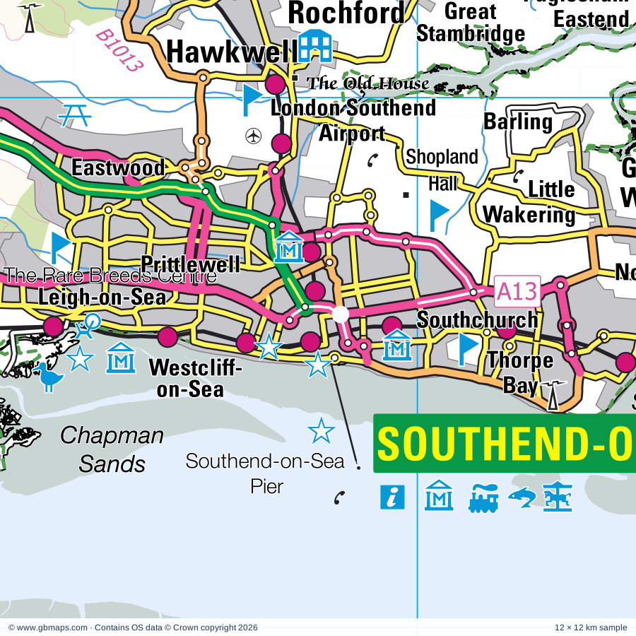
Southend-on-Sea regional road map. Full 60 × 60 km PDF, SVG and Illustrator files, with a free PDF sample.

GBMAPS.COM

Southend-on-Sea Regional Road Map

Call Us Now for Help01751 473136

GREAT BRITAIN ROAD ATLAS · 1:250,000 GB-570-0180

Southend-on-Sea & surrounding area

Explore the full 60 × 60 km Southend-on-Sea regional road map at 1:250,000, covering Chelmsford, Tilbury, Gravesend, Grays, Basildon. Compare the complete coverage below; a detailed PDF sample is available free.

SOUTHEND-ON-SEA & SURROUNDING AREAREGIONAL ROAD MAP
60 × 60 km · Full map previewDownload the free SVG ↓

INSIDE THE FULL 60 × 60 KM MAP

Explore the Southend-on-Sea map area

1:250,000 cartography

Towns, villages & places

More mapped places (237)

Roads across this sheet

M2, M11, M20, M25, M26, A2, A12, A13, A20, A21, A25, A26, A102, A104, A110, A112, A113, A114, A116, A117, A118, A121, A123, A124

More road numbers

A125, A126, A127, A128, A129, A130, A132, A138, A176, A205, A206, A207, A208, A209, A210, A211, A220, A221, A222, A223, A224, A225, A226, A227, A228, A229, A230, A231, A232, A233, A249, A250, A252, A274, A278, A282, A289, A296, A406, A414, A1008, A1009, A1012, A1013, A1014, A1015, A1016, A1019, A1020, A1023, A1025, A1060, A1069, A1083, A1089, A1090, A1099, A1112, A1114, A1153, A1158, A1159, A1160, A1168, A1169, A1199, A1235, A1240, A1245, A1251, A1306, A1400, A2000, A2001, A2016, A2018, A2026, A2041, A2204, A2212, A2213, A2260, A2500, B117, B148, B149, B168, B170, B172, B173, B174, B175, B178, B181, B182, B184, B186, B187, B188, B189, B192, B210, B212, B213, B226, B228, B245, B250, B251, B255, B258, B260, B261, B262, B263, B264, B265, B269, B1002, B1006, B1007, B1008, B1009, B1010, B1012, B1013, B1014, B1015, B1016, B1017, B1018, B1019, B1021, B1022, B1026, B1036, B1133, B1137, B1335, B1393, B1418, B1419, B1420, B1421, B1459, B1464, B2000, B2001, B2002, B2004, B2005, B2006, B2007, B2008, B2010, B2012, B2015, B2016, B2017, B2019, B2020, B2024, B2025, B2026, B2042, B2045, B2069, B2097, B2108, B2158, B2162, B2163, B2173, B2174, B2175, B2186, B2211, B2212, B2214, B2228, B2231, B2246, B2500

Rivers & waterways

Chelmer & Blackwater Navigation, Cobbin's Brook, Great Stour, Langford Cut (canal), River Beult, River Blackwater, River Can, River Chelmer, River Crouch, River Len, River Medway, River Stort

More waterways

River Ter

Landmarks & landscape

Ambley Wood Nature Reserve, Arena Essex Raceway, Asheldham Pits Nature Reserve, BBC Essex Garden, Barleylands Craft Village, Barleylands Farm Centre, Barton's Point Coastal Park, Bata Estate, Bay Museum, Bayford Meadows Kart Circuit, Beacon Wood Country Park, Beam Valley Country Park

More named features

Bearsted Vineyard, Beaver Water World, Belhus Woods Country Park, and Belhus Woods Country Park Lakes Fishing Venue, Belmont, Belmont House and Gardens, Bentif Art Gallery, Blake Hall, Blake's Wood Nature Reserve, Boughton Monchelsea Place, Boxley Abbey, Brands Hatch Motor Racing Circuit, Bredgar and Wormshill Light Railway, Brentwood Museum, Brentwood R C Cathedral, Bromley Museum, Burnham-On-Crouch District Museum, Burnham Town Quay Museum, Camer Park Country Park, Canvey Heights, Capstone Farm, Capstone Farm Country Park, Visitor Centre, Castle, Castle Point Transport Museum, Chafford Gorges Visitor Centre, Chartwell, Chelmsford Cathedral, Chelmsford Museum & The Essex Regiment Museum, Essex Yeomanry Museum Collection, Sandford Mill Museum, Christmas Tree Farm, Cliffe Fort, Coalhouse Fort, Cobham Hall, Cory Environmental Trust Visitor Centre, Country Park, Crofton Roman Villa, Cromer's Wood Nature Reserve, Crossness Pumping Station, Danbury Common Nature Reserve, Danbury Country Park, Danson House, Dartford Borough Museum, Dickens World, Diggerland, Doddington Place Gardens, Down House, Dunton Road Solar Farm, Eagle Heights, Eastbury Manor House, Elmley Marshes Nature Reserve, Elmley Nature Reserve, Eltham Palace, Emmetts Garden, Epping Forest Centres, Epping Ongar Railway, ExCeL Exhibition Centre, Eynsford Castle, FOAL Animal Rescue Centre, Fairlop Waters Country Park, Faitkytes Arts Centre, Farningham Woods Nature Reserve, Faversham Stone Chapel, Festival Leisure Park, Firepower- The Royal Artillery Museum, Greenwich Heritage Centre, Fort Amherst Heritage Park and Caverns, Go Ape Leeds Castle, Grangewaters Country Park, Gravesend Civil Defence Bunker, Gravesham Museum, New Tavern Fort, Great Comp Garden, Great Stocks Vineyard, Green Visitor Centre, Greenwich Observatory, Greenwich Theatre and Art Gallery, Greenwich Gateway Visitor Centre, Guildhall Museum, Drapers Museum of Bygones, The Old Brook Pumping Museum, Six Poor Travellers House, Watts Charity, HMS Ocelot, HMS Cavalier, HMS Gannett, Historic Dockyard, Hadleigh Castle, Hadleigh Castle 9rems of), Hadleigh Country Park, Hadlow College Nature Reserve, Hainault Forest Country Park, Hall Place, Hanningfield Reservoir Nature Reserve, Havering Country Park, Havering Visitor Centre, Heritage Centre & Folk Museum, Dutch Cottage Museum, High Elms Country Park, Hill Hall, Holly Hill Wood Nature Reserve, Hoo Fort, Hornchurch Country Park, Horndon on the Hill Woolmarket, Hyde Hall Gardens, Hylands House, Ightham Mote, Ingatestone Hall, Ingrebourne Valley, Jeskyns Country Park, Jubilee Park, Kelvedon Hatch Nuclear Secret Bunker, Kemsing Heritage Centre, Kent Life Farm Attraction, Kit's Coty House, Kit's Coty House, Little Kit's Coty House, Knole House, Knole House and Garden, Land Rover Adventure Zone, Langdon Conservation Centre, Langdon Hills Country Park, Langdon Hills Country Park (Westley Heights), Langdon Nature Reserve, Leeds Castle, Leigh Heritage Centre, Lenham Cross, Lenham Cross (Hill Figure), Lenham Solar Park, Lesnes Abbey (remains of), Leybourne Lakes Country Park, Log Church, London Gateway Container Terminal, Luddenham Court, Lullingstone Castle, Lullingstone Castle World Garden, Lullingstone Park, Lullingstone Park Nature Reserve, Lullingstone Roman Villa, Maidstone Museum, Tyrwhitt-Drake Museum of Carriages, Maldon District Museum, Combined Military Services Museum, Maeldune Heritage Centre, Malmaynes Hall Solar Farm, Mangapps Farm Railway, Mangapps Railway Museum, Manor Park Country Park, Mardyke Valley Beauty Spot, Marina, Burnham Sailing Club, Maritime Greenwich (World Heritage Centre), Marsh Farm Country Park, Mill Yard Craft Centre, Milton Chantry, Milton Creek Country Park, Minister Abbey, Minster Abbey, Minster Gatehouse, Mote House, Mote Park Miniature Railway, Moulsham Mill, Mountnessing Windmill, Museum of Power, New Hall Vineyard, Noak Bridge Nature Reserve, Norsey Wood Nature Reserve, North Weald Airfield Museum and Memorial, Northey Island Nature Reserve, Northward Hill Nature Reserve, Oad Street Craft Centre, Old Leigh Studios, Old MacDonald's Educational Farm Park, Old Soar Manor, Owletts, Oxleas Woodlands Nature Reserve, Parndon Wood Nature Reserve, Peter Pan's Adventure Island, Pheasanthouse Wood Nature Reserve, Priory Gardens, Prittlewell Priory, Purfleet Heritage and Military Centre, Quebec House, Queenborough Guildhall Museum, Queens Park Country Park, Rainham Hall, Rainham Marshes Visitor Centre, Ranscombe Farm Country Park, Rayleigh Mount, Rayleigh Museum, Red House, Redbridge Local History Museum, Redwings Horse Sanctuary, Riverhill House Garden, Riverside Country Park, Visitor Centre, Rochester Art Gallery, Rochester Castle, Rochester Cathedral, Rochford & District Off Road Centre, Roding Valley Meadows Nature Reserve, Royal Engineers Museum, Kent Police Museum, Scadbury Park Nature Reserve, Sevenoaks Museum and Gallery, Sevenoaks Wildfowl Reserve Nature Reserve, Sheerness Heritage Centre, Sheppey Solar Park, Shopland Hall, Shoreham Aircraft Museum, Shoreham Cross (Hill Figure), Shorne Woods Country Park, Southchurch Hall Museum, Southend Cliff Lift, Southend Pier Museum, Southend Central Museum, Southend-on-Sea Pier, Southend-on-Sea Pier Railway, Southend-on-Sea Sea Life Centre, Squerryes Court, St John's Jerusalem, St Leonard's Tower, Stables Visitor Centre, Stanford Warren Nature Reserve, Stock Towermill, Stoneacre, Temple Manor, Teston Bridge Country Park, Thames Barrier Visitor Centre, The Beecroft Art Gallery, The Cater Museum, The Chase Nature Reserve, The Foord Almshouses, Restoration House, The Friars, The Haven Plotlands Museum, The Lynn Tait Gallery, The Millennium Centre Visitor Centre, The Millennium Visitor Centre, Eastbrookend Country Park, The Old House, The Rare Breeds Centre, The Strand Leisure Park, The Thames Chase Forest Centre, The Tithe Barn Agricultural and Folk Mus, Thorndon Country Park, Thorndon Countryside Centre, Thurnham Castle, Thurrock Local History Museum, Tilbury Fort, Titsey Place, Tropical Wings Butterflies and Bird Gardens, Trosley Country Park, Visitor Centre, Two Tree Island Nature Reserve, Tyland Barn Wildlife Conservation Visitor Centre, Upminster Mill, Upnor Castle, Upton Park (Boleyn Ground) Sports Venue, Valence House Museum, Visitor Centre, Walton Hall Farm Museum, Wat Tyler Country Park, Watts Charity, The Old Brook Pumping Station, Weald Country Park, Well Hall Pleasaunce, Wellgate Community Farm, White Horse Wood Country Park, Wick Country Park, Woolwich Borough Museum
Local authority & parish coverage

Wholly or partly within the full map rectangle. These boundaries are coverage information, not additional artwork layers.

  • Ashford DistrictPartly within
  • Barking and Dagenham London BoroWholly within
  • Basildon DistrictWholly within
  • Bexley London BoroWholly within
  • Braintree DistrictPartly within
  • Brentwood DistrictWholly within
  • Bromley London BoroPartly within
  • Castle Point DistrictWholly within
  • Chelmsford DistrictPartly within
  • Dartford DistrictWholly within
  • Epping Forest DistrictPartly within
  • Gravesham DistrictWholly within
  • Greenwich London BoroPartly within
  • Harlow DistrictPartly within
  • Havering London BoroWholly within
  • Lewisham London BoroPartly within
  • Maidstone DistrictPartly within
  • Maldon DistrictPartly within
  • MedwayWholly within
  • Newham London BoroPartly within
  • Redbridge London BoroPartly within
  • Rochford DistrictPartly within
  • Sevenoaks DistrictPartly within
  • Southend-on-SeaWholly within
  • Swale DistrictPartly within
  • Tandridge DistrictPartly within
  • ThurrockWholly within
  • Tonbridge and Malling DistrictPartly within
  • Waltham Forest London BoroPartly within
Wards & electoral divisions 454 areas
  • Abbey Ward
  • Abbey Wood Ward
  • Aldborough Ward
  • Alibon Ward
  • All Saints Ward
  • Allington & Bridge Ward
  • Althorne Ward
  • Appleton Ward
  • Ash and New Ash Green Ward
  • Aveley Ward
  • Aylesford North & North Downs Ward
  • Aylesford South & Ditton Ward
  • Barking Riverside Ward
  • Barkingside Ward
  • Barming Heath & Teston Ward
  • Barnehurst Ward
  • Beam Park Ward
  • Beam Ward
  • Bean & Village Park Ward
  • Bearsted & Downswood Ward
  • Beckton Ward
  • Becontree Ward
  • Belfairs Ward
  • Belhus Ward
  • Belvedere Ward
  • Bexleyheath Ward
  • Bickley & Sundridge Ward
  • Bicknacre and East and West Hanningfield Ward
  • Biggin Hill Ward (part)
  • Billericay East Ward
  • Billericay West Ward
  • Birling, Leybourne & Ryarsh Ward
  • Blackfen & Lamorbey Ward
  • Blackheath Ward (part)
  • Blackheath Westcombe Ward (part)
  • Blackmore & Doddinghurst Ward
  • Blendon & Penhill Ward
  • Blenheim Park Ward
  • Bobbing, Iwade and Lower Halstow Ward
  • Boleyn Ward
  • Borden and Grove Park Ward
  • Boreham and The Leighs Ward (part)
  • Borough Green & Platt Ward
  • Boughton Monchelsea & Chart Sutton Ward (part)
  • Bourne Ward (part)
  • Boxley Downs Ward
  • Brasted, Chevening & Sundridge Ward (part)
  • Brent Ward
  • Brentwood North Ward
  • Brentwood South Ward
  • Brentwood West Ward
  • Bridge Ward
  • Bridge Ward
  • Brizes, Stondon Massey & South Weald Ward
  • Bromley Common & Holwood Ward
  • Bromley Town Ward (part)
  • Broomfield and The Walthams Ward (part)
  • Buckhurst Hill East & Whitebridge Ward
  • Buckhurst Hill West Ward
  • Burnham Ward
  • Burnham-on-Crouch North Ward (part)
  • Burnham-on-Crouch South Ward
  • Burstead Ward
  • Bush Fair Ward
  • Cann Hall Ward (part)
  • Canning Town North Ward (part)
  • Canning Town South Ward (part)
  • Canvey Island Central Ward
  • Canvey Island East Ward
  • Canvey Island North Ward
  • Canvey Island South Ward
  • Canvey Island Winter Gardens Ward
  • Castledon & Crouch Ward
  • Chadwell Heath Ward
  • Chadwell St. Mary Ward
  • Chadwell Ward
  • Chafford Hundred East Ward
  • Chafford Hundred West Ward
  • Chalk Ward
  • Chalkwell Ward
  • Chalkwell Ward
  • Charing Ward (part)
  • Charlton Hornfair Ward
  • Charlton Village & Riverside Ward
  • Chatham Central & Brompton Ward
  • Chelmer Village and Beaulieu Park Ward (part)
  • Chelmsford Rural West Ward (part)
  • Chelsfield Ward
  • Chigwell with Lambourne Ward
  • Chingford Green Ward (part)
  • Chislehurst Ward
  • Church Langley North & Newhall Ward (part)
  • Church Langley South & Potter Street Ward
  • Churchfields Ward (part)
  • Clayhall Ward
  • Clementswood Ward
  • Coldharbour & Perry Street Ward
  • Corringham & Fobbing Ward
  • Coxheath & Farleigh Ward
  • Cranbrook Ward
  • Cranham Ward
  • Crayford Ward
  • Crockenhill and Well Hill Ward
  • Crook Log Ward
  • Custom House Ward
  • Cuxton, Halling & Riverside Ward
  • Darenth Ward
  • Darwin Ward (part)
  • Denton Ward
  • Downhall & Rawreth Ward
  • Downham Ward (part)
  • Downs West Ward (part)
  • Dunton Green and Riverhead Ward
  • East Downs Ward (part)
  • East Greenwich Ward (part)
  • East Ham South Ward
  • East Ham Ward
  • East Malling, West Malling & Offham Ward
  • East Tilbury, Linford & West Tilbury Ward
  • East Wickham Ward
  • East and West Peckham, Mereworth & Wateringbury Ward (part)
  • Eastbrook & Rush Green Ward
  • Eastbury Ward
  • Eastwood Park Ward
  • Ebbsfleet Ward
  • Elm Park Ward
  • Eltham Page Ward
  • Eltham Park & Progress Ward
  • Eltham Town & Avery Hill Ward
  • Emerson Park Ward
  • Epping East Ward
  • Epping West & Rural Ward (part)
  • Erith Ward
  • Eynsford Ward
  • Fairlop Ward
  • Falconwood & Welling Ward
  • Fant & Oakwood Ward
  • Farnborough & Crofton Ward
  • Farningham, Horton Kirby and South Darenth Ward
  • Fawkham and West Kingsdown Ward
  • Forest Gate North Ward (part)
  • Forest Gate South Ward (part)
  • Fort Horsted Ward
  • Fort Pitt Ward
  • Foulness & The Wakerings Ward (part)
  • Fryerns Ward
  • Fullwell Ward
  • Galleywood Ward
  • Gascoigne Ward
  • Gillingham North Ward
  • Gillingham South Ward
  • Goat Hall Ward
  • Goodmayes Ward
  • Gooshays Ward
  • Goresbrook Ward
  • Grange Hill Ward
  • Grays Riverside Ward
  • Grays Town Ward
  • Great Baddow East Ward
  • Great Baddow West Ward
  • Great Parndon Ward (part)
  • Great Totham Ward (part)
  • Green Street East Ward
  • Green Street West Ward
  • Greenhithe & Knockhall Ward
  • Greenwich Peninsula Ward (part)
  • Grove Green & Vinters Park Ward
  • Grove Park Ward (part)
  • Hacton Ward
  • Hadleigh St. James Ward
  • Hainault Ward
  • Halstead, Knockholt and Badgers Mount Ward
  • Harold Wood Ward
  • Harrietsham, Lenham & North Downs Ward (part)
  • Hartley and Hodsoll Street Ward
  • Hartlip, Newington and Upchurch Ward
  • Hatch Lane & Highams Park North Ward (part)
  • Hatfield Peverel & Terling Ward (part)
  • Havering-atte-Bower Ward
  • Hawkwell East Ward
  • Hawkwell West Ward
  • Hayes & Coney Hall Ward (part)
  • Headcorn & Sutton Valence Ward (part)
  • Heath Ward
  • Heath Ward
  • Heaton Ward
  • Hempstead & Wigmore Ward
  • Herongate, Ingrave & West Horndon Ward
  • Hextable Ward
  • Heybridge East Ward
  • Heybridge West Ward
  • High Street Ward
  • Higham & Shorne Ward
  • Higham Ward (part)
  • Hildenborough Ward (part)
  • Hither Green Ward (part)
  • Hockley & Ashingdon Ward
  • Hockley Ward
  • Homewood Ward
  • Hoo St. Werburgh & High Halstow Ward
  • Hullbridge Ward
  • Hutton East Ward
  • Hutton North Ward
  • Hutton South Ward
  • Hylands & Harrow Lodge Ward
  • Ilford Town Ward
  • Ingatestone, Fryerning & Mountnessing Ward
  • Istead Rise, Cobham & Luddesdown Ward
  • Joyden's Wood Ward
  • Kemsing Ward
  • Kemsley Ward
  • Kidbrooke Park Ward
  • Kidbrooke Village & Sutcliffe Ward (part)
  • Kings Hill Ward
  • Kursaal Ward
  • Laindon Park Ward
  • Langdon Hills Ward
  • Larkfield Ward
  • Latton Bush & Stewards Ward
  • Lee Chapel North Ward
  • Lee Green Ward (part)
  • Leeds & Langley Ward
  • Leigh Ward
  • Leigh and Chiddingstone Causeway Ward (part)
  • Leytonstone Ward (part)
  • Limpsfield Ward (part)
  • Little Baddow, Danbury and Sandon Ward
  • Little Ilford Ward
  • Little Parndon & Town Centre Ward (part)
  • Little Thurrock Blackshots Ward
  • Little Thurrock Rectory Ward
  • Lodge Ward
  • Longbridge Ward
  • Longfield, New Barn & Southfleet Ward
  • Longlands Ward
  • Loose & Linton Ward (part)
  • Lordswood & Walderslade Ward
  • Loughton Fairmead Ward
  • Loughton Forest Ward
  • Loughton Roding Ward
  • Loughton St. John's Ward
  • Loxford Ward
  • Luton Ward
  • Maldon East Ward
  • Maldon North Ward
  • Maldon South Ward
  • Maldon West Ward
  • Manor Park Ward
  • Marconi Ward
  • Marden & Yalding Ward (part)
  • Mark Hall Ward (part)
  • Marshalls & Rise Park Ward
  • Mawneys Ward
  • Mayesbrook Ward
  • Mayfield Ward
  • Mayland Ward
  • Maypole & Leyton Cross Ward
  • Meopham North Ward
  • Meopham South & Vigo Ward
  • Middle Park & Horn Park Ward
  • Milton Regis Ward
  • Milton Ward
  • Minster Cliffs Ward
  • Monkhams Ward (part)
  • Mottingham Ward
  • Mottingham, Coldharbour & New Eltham Ward
  • Moulsham Lodge Ward
  • Moulsham and Central Ward
  • Murston Ward
  • Nethermayne Ward
  • Netteswell Ward (part)
  • Newbury Ward
  • Newtown Ward
  • North Weald Bassett Ward
  • Northbury Ward
  • Northfleet & Springhead Ward
  • Northumberland Heath Ward
  • Ockendon Ward
  • Ongar Ward
  • Orpington Ward
  • Orsett, Horndon & Bulphan Ward
  • Otford and Shoreham Ward
  • Oxted North Ward (part)
  • Oxted South Ward (part)
  • Painters Ash Ward
  • Palace Wood Ward
  • Park Wood & Mangravet Ward
  • Parsloes Ward
  • Passmores Ward (part)
  • Patching Hall Ward
  • Pelham Ward
  • Penenden Heath Ward
  • Petts Wood & Knoll Ward
  • Pilgrims Hatch Ward
  • Pilgrims with Ightham Ward
  • Pitsea North West Ward
  • Pitsea South East Ward
  • Plaistow North Ward (part)
  • Plaistow South Ward
  • Plaistow Ward (part)
  • Plaistow West & Canning Town East Ward (part)
  • Plashet Ward
  • Plumstead & Glyndon Ward
  • Plumstead Common Ward
  • Princes Park Ward
  • Princes Ward
  • Priory Ward (part)
  • Prittlewell Ward
  • Purfleet-on-Thames Ward
  • Purleigh Ward
  • Queenborough and Halfway Ward
  • Rainham & Wennington Ward
  • Rainham North Ward
  • Rainham South East Ward
  • Rainham South West Ward
  • Rettendon and Runwell Ward
  • Ringlestone Ward
  • Riverview Park Ward
  • Roche North & Rural Ward
  • Roche South Ward
  • Rochester East & Warren Wood Ward
  • Rochester West & Borstal Ward
  • Roman Ward
  • Rosherville Ward
  • Royal Albert Ward
  • Royal Victoria Ward (part)
  • Roydon & Lower Nazeing Ward (part)
  • Rural East Ward (part)
  • Rush Green & Crowlands Ward
  • Seal & Weald Ward (part)
  • Senacre Ward
  • Seven Kings Ward
  • Sevenoaks Eastern Ward
  • Sevenoaks Kippington Ward
  • Sevenoaks Northern Ward
  • Sevenoaks Town and St. John's Ward
  • Sheerness Ward
  • Shenfield Ward
  • Sheppey Central Ward
  • Sheppey East Ward (part)
  • Shepway Ward
  • Shoeburyness Ward
  • Shooters Hill Ward
  • Shortlands & Park Langley Ward (part)
  • Sidcup Ward
  • Singlewell Ward
  • Slade Green & Northend Ward
  • Snodland East & Ham Hill Ward
  • Snodland West & Holborough Lakes Ward
  • South Hanningfield, Stock and Margaretting Ward
  • South Hornchurch Ward
  • South Woodford Ward (part)
  • South Woodham-Chetwood and Collingwood Ward
  • South Woodham-Elmwood and Woodville Ward
  • Southchurch Ward
  • Southminster Ward (part)
  • Springfield North Ward (part)
  • Squirrels Heath Ward
  • St. Alban's Ward
  • St. Andrew's Ward
  • St. Andrews Ward
  • St. Ann's Ward (part)
  • St. Edward's Ward
  • St. George's Ward
  • St. Laurence Ward
  • St. Luke's Ward
  • St. Martin's Ward
  • St. Mary Cray Ward
  • St. Mary's & St. James Ward
  • St. Mary's Island Ward
  • St. Mary's Ward
  • St. Michael's Ward
  • St. Paul's Cray Ward
  • Stanford-le-Hope South Ward
  • Stifford Ward
  • Stone Castle Ward
  • Stone House Ward
  • Strood North & Frindsbury Ward
  • Strood Rural Ward
  • Strood West Ward
  • Sumners & Kingsmoor Ward
  • Swanley Christchurch and Swanley Village Ward
  • Swanley St. Mary's Ward
  • Swanley White Oak Ward
  • Swanscombe Ward
  • Sweyne Park & Grange Ward
  • Tarpots Ward
  • Tatsfield & Titsey Ward (part)
  • Temple Hill Ward
  • Teynham and Lynsted Ward (part)
  • Thames View Ward
  • Thamesmead East Ward
  • Thamesmead Moorings Ward
  • The Homesteads & Stanford-le-Hope North Ward
  • The Lawns Ward
  • The Meads Ward
  • Theydon Bois with Passingford Ward
  • Thorpe Ward
  • Thundersley North Ward
  • Thundersley South Ward
  • Tilbury Riverside Ward
  • Tilbury St. Chads Ward
  • Tillingham Ward (part)
  • Tollesbury Ward (part)
  • Tolleshunt D'arcy Ward (part)
  • Tovil Ward
  • Town Ward
  • Town Ward
  • Trench Ward (part)
  • Trinity Ward
  • Trinity Ward
  • Twydall Ward
  • Upminster Ward
  • Upper Weald Ward (part)
  • Valence Ward
  • Valentines Ward
  • Victoria Ward
  • Village Ward
  • Walderslade Ward
  • Wall End Ward
  • Waltham Abbey North Ward (part)
  • Waltham Abbey South & Rural Ward (part)
  • Wanstead Park Ward (part)
  • Wanstead Village Ward (part)
  • Warley Ward
  • Warlingham East & Chelsham & Farleigh Ward (part)
  • Waterhouse Farm Ward
  • Watling Ward (part)
  • Watling Ward
  • Wayfield & Weeds Wood Ward
  • West Downs Ward
  • West Ham Ward (part)
  • West Heath Ward
  • West Hill Ward
  • West Leigh Ward
  • West Shoebury Ward
  • West Thamesmead Ward
  • West Thurrock & South Stifford Ward
  • Westborough Ward
  • Westcourt Ward
  • Westerham and Crockham Hill Ward (part)
  • Whalebone Ward
  • Wheatley Ward
  • Whitehill & Windmill Hill Ward
  • Wickford North Ward
  • Wickford Park Ward
  • Wickham Bishops and Woodham Ward (part)
  • Wilmington, Sutton-at-Hone & Hawley Ward
  • Woodlands Ward
  • Woodstock Ward
  • Woolwich Arsenal Ward
  • Woolwich Common Ward
  • Woolwich Dockyard Ward
  • Writtle Ward
Civil parishes & communities 269 areas
  • Abbess Beauchamp and Berners Roding CP (part)
  • Addington CP
  • Allhallows CP
  • Althorne CP
  • Ash-cum-Ridley CP
  • Asheldham CP
  • Ashingdon CP
  • Aylesford CP
  • Badgers Mount CP
  • Bapchild CP
  • Barling Magna CP
  • Barming CP
  • Bean CP
  • Bearsted CP
  • Bicknor CP
  • Billericay CP
  • Birling CP
  • Blackmore, Hook End and Wyatts Green CP
  • Bobbing CP
  • Bobbingworth CP
  • Borden CP
  • Boreham CP (part)
  • Borough Green CP
  • Boughton Malherbe CP (part)
  • Boughton Monchelsea CP (part)
  • Bowers Gifford and North Benfleet CP
  • Boxley CP
  • Bradwell-on-Sea CP (part)
  • Brasted CP (part)
  • Bredgar CP
  • Bredhurst CP
  • Broomfield CP (part)
  • Broomfield and Kingswood CP
  • Buckhurst Hill CP
  • Burham CP
  • Burnham-on-Crouch CP (part)
  • Canewdon CP
  • Canvey Island CP
  • Challock CP (part)
  • Charing CP (part)
  • Chart Sutton CP (part)
  • Chelmer CP
  • Chelmsford Garden CP (part)
  • Chelsham and Farleigh CP (part)
  • Chevening CP (part)
  • Chignall CP (part)
  • Chigwell CP
  • Cliffe and Cliffe Woods CP
  • Cobham CP
  • Cold Norton CP
  • Cooling CP
  • Coxheath CP
  • Crockenhill CP
  • Cuxton CP
  • Danbury CP
  • Darenth CP
  • Dengie CP (part)
  • Detling CP
  • Ditton CP
  • Doddinghurst CP
  • Doddington CP
  • Downswood CP
  • Dunton Green CP
  • East Farleigh CP
  • East Hanningfield CP
  • East Malling & Larkfield CP
  • East Peckham CP (part)
  • East Sutton CP (part)
  • Eastchurch CP (part)
  • Eastling CP
  • Epping CP
  • Epping Upland CP
  • Eynsford CP
  • Farningham CP
  • Faversham CP (part)
  • Fawkham CP
  • Foulness CP (part)
  • Frindsbury Extra CP
  • Frinsted CP
  • Fyfield CP
  • Galleywood CP
  • Goldhanger CP (part)
  • Great Baddow CP
  • Great Burstead and South Green CP
  • Great Totham CP (part)
  • Great Wakering CP (part)
  • Hadlow CP (part)
  • Halling CP
  • Halstead CP
  • Harrietsham CP
  • Hartley CP
  • Hartlip CP
  • Hatfield Peverel CP (part)
  • Hawkwell CP
  • Hazeleigh CP
  • Herongate and Ingrave CP
  • Hextable CP
  • Heybridge Basin CP
  • Heybridge CP
  • High Halstow CP
  • High Laver CP (part)
  • High Ongar CP
  • Higham CP
  • Highwood CP
  • Hildenborough CP (part)
  • Hockley CP
  • Hollingbourne CP
  • Hoo St. Werburgh CP
  • Horton Kirby and South Darenth CP
  • Hucking CP
  • Hullbridge CP
  • Hunton CP (part)
  • Ightham CP
  • Ingatestone and Fryerning CP
  • Isle of Grain CP
  • Iwade CP
  • Kelvedon Hatch CP
  • Kemsing CP
  • Kings Hill CP
  • Knockholt CP
  • Lambourne CP
  • Langford CP (part)
  • Langley CP
  • Latchingdon CP
  • Leaveland CP (part)
  • Leeds CP
  • Leigh CP (part)
  • Leigh-on-Sea CP
  • Lenham CP (part)
  • Leybourne CP
  • Leysdown CP (part)
  • Limpsfield CP (part)
  • Linton CP (part)
  • Little Baddow CP
  • Little Burstead CP
  • Little Laver CP (part)
  • Little Totham CP (part)
  • Longfield and New Barn CP
  • Loose CP
  • Loughton CP
  • Lower Halstow CP
  • Luddenham CP (part)
  • Luddesdown CP
  • Lynsted with Kingsdown CP
  • Magdalen Laver CP
  • Maldon CP
  • Margaretting CP
  • Matching CP (part)
  • Mayland CP
  • Meopham CP
  • Mereworth CP
  • Milstead CP
  • Minster-on-Sea CP
  • Moreton CP
  • Mountnessing CP
  • Mundon CP
  • Navestock CP
  • Nazeing CP (part)
  • Nettlestead CP (part)
  • Newington CP
  • Newnham CP
  • Noak Bridge CP
  • North Fambridge CP
  • North Weald Bassett CP
  • Norton, Buckland and Stone CP
  • Oare CP (part)
  • Offham CP
  • Ongar CP
  • Ospringe CP (part)
  • Otford CP
  • Otham CP
  • Otterden CP
  • Oxted CP (part)
  • Paglesham CP
  • Platt CP
  • Plaxtol CP
  • Purleigh CP
  • Queenborough CP
  • Ramsden Bellhouse CP
  • Ramsden Crays CP
  • Rawreth CP
  • Rayleigh CP
  • Rettendon CP
  • Riverhead CP
  • Rochford CP
  • Rodmersham CP
  • Roxwell CP (part)
  • Roydon CP (part)
  • Runwell CP
  • Ryarsh CP
  • Sandon CP
  • Seal CP
  • Sevenoaks CP
  • Sevenoaks Weald CP (part)
  • Sheerness CP
  • Shipbourne CP
  • Shoreham CP
  • Shorne CP
  • Shotgate CP
  • Snodland CP
  • South Hanningfield CP
  • South Woodham Ferrers CP
  • Southfleet CP
  • Southminster CP (part)
  • Springfield CP (part)
  • St. Lawrence CP
  • St. Mary Hoo CP
  • Stalisfield CP
  • Stambridge CP
  • Stanford Rivers CP
  • Stansted CP
  • Stapleford Abbotts CP
  • Stapleford Tawney CP
  • Steeple CP
  • Stock CP
  • Stockbury CP
  • Stoke CP
  • Stondon Massey CP
  • Stone CP
  • Stow Maries CP
  • Sundridge with Ide Hill CP (part)
  • Sutton CP
  • Sutton Valence CP (part)
  • Sutton-at-Hone and Hawley CP
  • Swanley CP
  • Swanscombe and Greenhithe CP
  • Tatsfield CP
  • Teston CP
  • Teynham CP
  • Theydon Bois CP
  • Theydon Garnon CP
  • Theydon Mount CP
  • Throwley CP (part)
  • Thurnham CP
  • Tillingham CP (part)
  • Titsey CP (part)
  • Tollesbury CP (part)
  • Tolleshunt D'arcy CP (part)
  • Tolleshunt Major CP (part)
  • Tonge CP
  • Tovil CP
  • Trottiscliffe CP
  • Tunstall CP
  • Ulcombe CP (part)
  • Ulting CP (part)
  • Upchurch CP
  • Vigo CP
  • Waltham Abbey CP (part)
  • Wateringbury CP
  • West Farleigh CP
  • West Hanningfield CP
  • West Horndon CP
  • West Kingsdown CP
  • West Malling CP
  • West Peckham CP
  • Westerham CP (part)
  • Wichling CP
  • Wickford CP
  • Wickham Bishops CP (part)
  • Willingale CP
  • Wilmington CP
  • Woodham Ferrers and Bicknacre CP
  • Woodham Mortimer CP
  • Woodham Walter CP
  • Wormshill CP
  • Wouldham CP
  • Writtle CP
  • Wrotham CP
  • Yalding CP (part)

Source: the GBMaps road atlas, OS Boundary-Line and postcode mapping datasets. Source editions are being checked for publication. Unmarked boundary names are wholly within the sheet; “part” means the map edge crosses the area.

Place lists are selected from the map source, not a complete gazetteer. Named features describe the cartography; visitor facilities and opening status are not verified. The free sample covers only 12 × 12 km of this larger sheet.

INSIDE YOUR DOWNLOAD

A proper road map, in useful formats

Road classifications, towns and villages, railways, rivers, landscape detail and tourist symbols, brought together in the GBMaps regional road atlas style.

PDF filePDFSVG fileSVGAdobe Illustrator AI fileAi

PDF for the finished map. SVG and layered Illustrator artwork for adapting colours, adding your own information and preparing designs.

THE FINISHED SHEET

Designed for print and presentation

Map coverage
60 × 60 km
Sample coverage
12 × 12 km
Print layout
A3 landscape · enlarged 1:250k cartography
Sheet furniture
Border, scale bar, key & north arrow

A few useful details

What changes when I select another square?

Select a surrounding square to bring it into the centre and reveal the maps around it. Each square is a different 60 × 60 km map. The preview, free sample and selected download change together. Neighbouring sheets overlap by 30 km so you can choose the coverage that suits you.

Is the free sample a vector map?

The on-page detail is an SVG. The free download is a separate 12 × 12 km PDF with a link to the full map. Please retain its copyright credits and product link when sharing it.

Can I buy a larger combined map?

These downloads are individual ready-made sheets. Contact GBMaps if you need a larger combined area.

FREE PDF SAMPLE

Your free map sample

Your free 12 × 12 km sample includes a link back to this map, so you can return for the full area whenever you need it.

Download free PDF sample ↓

Get your Southend-on-Sea map

Map download bundle

£24.00including VATOne payment

Pay securely

One payment. Your map stays open.

Your map download

Your map files

Preparing your download…

Checking your private download link…

Your map downloads

Already bought a map?

Find the downloads from your purchases.

Enter the email address you used at checkout. We’ll email you a private link to your available map downloads.