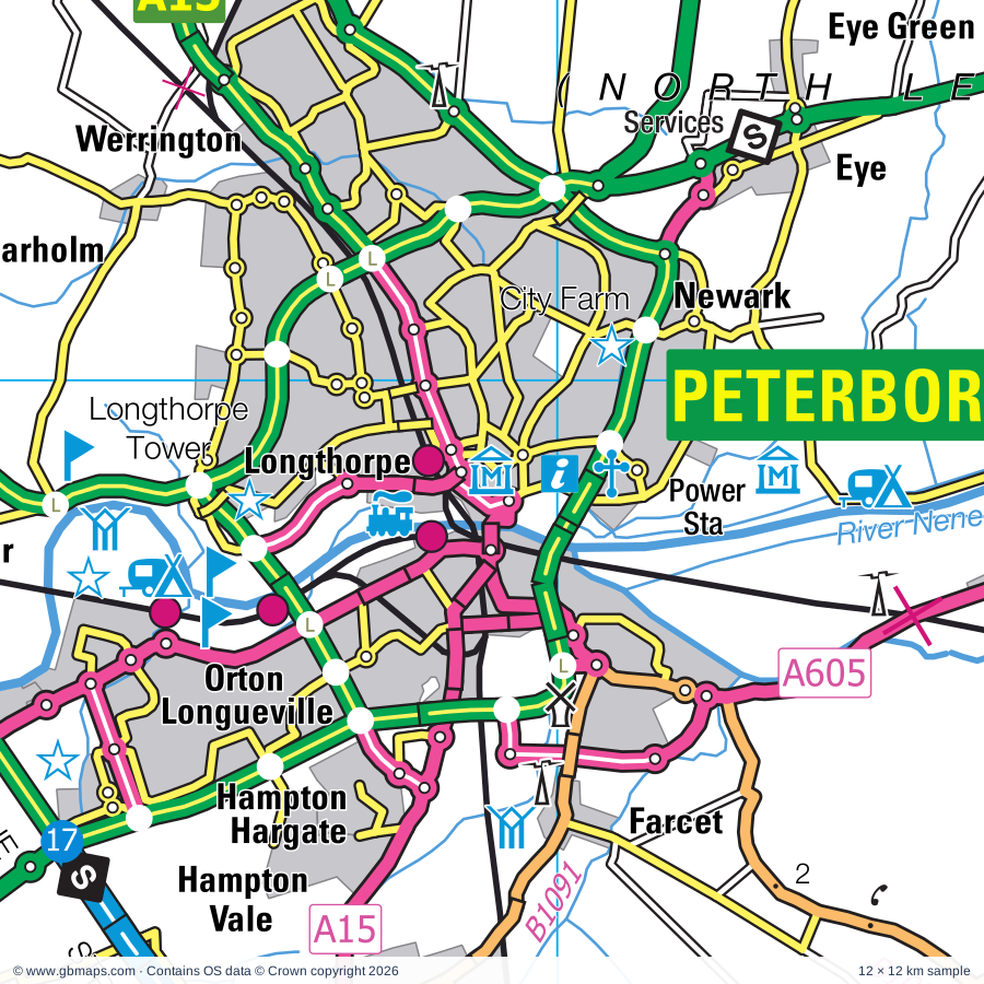
Peterborough regional road map. Full 60 × 60 km PDF, SVG and Illustrator files, with a free PDF sample.

GBMAPS.COM

Peterborough Regional Road Map

Call Us Now for Help01751 473136

GREAT BRITAIN ROAD ATLAS · 1:250,000 GB-540-0300

Peterborough & surrounding area

Explore the full 60 × 60 km Peterborough regional road map at 1:250,000, covering Ely, March, Wisbech, Chatteris, Ramsey. Compare the complete coverage below; a detailed PDF sample is available free.

PETERBOROUGH & SURROUNDING AREAREGIONAL ROAD MAP
60 × 60 km · Full map previewDownload the free SVG ↓

INSIDE THE FULL 60 × 60 KM MAP

Explore the Peterborough map area

1:250,000 cartography

Towns, villages & places

More mapped places (175)
  • Eldernell
  • Begdale
  • Parson Drove
  • Doddington
  • Coates
  • Elm
  • Christchurch
  • Throckenholt
  • Upwell
  • Eastrea
  • Benwick
  • Outwell
  • Emneth
  • Gorefield
  • Lakes End
  • Leverington
  • North Side
  • Thorney
  • Gedney Hill
  • Fitton End
  • Horseway
  • Manea
  • Welney
  • Emneth Hungate
  • Holbeach Drove
  • West Walton
  • Dowsdale
  • Nordelph
  • Pondersbridge
  • Pymoor
  • Ingleborough
  • Eye
  • Eye Green
  • Tydd St Mary
  • Mepal
  • Bury
  • Coveney
  • Little Downham
  • Farcet
  • Newborough
  • Ten Mile Bank
  • Witcham
  • Stow Bridge
  • Littleport
  • Denver
  • Fordham
  • Sutton
  • Warboys
  • Fenton
  • Hilgay
  • Somersham
  • Chettisham
  • Upwood
  • Wimbotsham
  • Wistow
  • Yaxley
  • Southery
  • Cowbit
  • Wentworth
  • Pidley
  • Witchford
  • Bexwell
  • Runcton Holme
  • Stow Bardolph
  • Peakirk
  • Colne
  • Gedney
  • Fleet
  • Watlington
  • Holme
  • Fleet Hargate
  • Old Hurst
  • Broughton
  • Holbeach
  • Glinton
  • Earith
  • Crimplesham
  • Haddenham
  • Woodhurst
  • Hop Pole
  • Whaplode
  • Marholm
  • Bluntisham
  • Frognall
  • Lutton
  • Moulton
  • West Dereham
  • Prickwillow
  • Saddle Bow
  • Stilton
  • Wennington
  • Northborough
  • Tottenhill
  • Wilburton
  • Conington
  • Woodwalton
  • Stuntney
  • Etton
  • Setchey
  • Aldreth
  • Loosegate
  • Weston
  • Folksworth
  • Guy's Head
  • Morborne
  • Stradsett
  • Haddon
  • Castor
  • Chesterton
  • Stretham
  • Clenchwarton
  • Denton
  • Caldecote
  • Wereham
  • Barway
  • Glatton
  • Ailsworth
  • Helpston
  • Sawtry
  • Needingworth
  • Wormegay
  • Maxey
  • Pode Hole
  • Wretton
  • Shouldham
  • Over
  • Upton
  • Willingham
  • Fincham
  • Holywell
  • Boughton
  • Broad Hill
  • Houghton
  • Ashton
  • Langtoft
  • Tongue End
  • Pinchbeck
  • Middleton
  • Coppingford
  • Upton
  • Lutton
  • Pinchbeck West
  • Baston
  • Surfleet
  • Twenty
  • Alconbury
  • Little Gidding
  • Upware
  • Northgate
  • Hamerton
  • Kenny Hill
  • East Winch
  • Wicken
  • Buckworth
  • Bawsey
  • Brampton
  • Winwick
  • Isleham
  • Risegate
  • Woolley
  • Barham
  • Beck Row
  • Ellington
  • Dyke
  • Fordham
  • Spaldwick
  • Easton
  • Wolferton
  • Freckenham
  • Haconby
  • Worlington
  • Dunsby
  • West Newton
  • Sandringham
  • Dowsby

Roads across this sheet

A1(M), A10, A14(M), A15, A16, A17, A134, A141, A142, A148, A149, A151, A152, A605, A1076, A1078, A1096, A1101, A1122, A1123, A1139, A1175, A1179, A1198

More road numbers

A1260, A1421, B198, B660, B1040, B1043, B1044, B1049, B1050, B1085, B1086, B1089, B1090, B1091, B1092, B1093, B1094, B1095, B1096, B1098, B1099, B1100, B1101, B1102, B1104, B1144, B1145, B1160, B1162, B1165, B1166, B1167, B1168, B1169, B1172, B1173, B1177, B1180, B1187, B1193, B1356, B1357, B1359, B1381, B1382, B1386, B1390, B1397, B1411, B1439, B1440, B1443, B1514, B1515, B1524, B1525

Rivers & waterways

Babingley River, Canal, Counter Drain, Cross Drain, Forty Foot or Vermuden's Drain, King's Dike, Little Ouse River, Middle Level Main Drain, New Bedford River or Hundred Foot Drain, New River, North Drove Drain, Old Bedford River

More waterways

Old Croft R, Old Croft River, Popham's Eau, Relief Channel, River Cam, River Delph, River Glen, River Great Ouse, River Kennett, River Lark, River Nar, River Nene, River Nene ( old course ), River Nene (old course), River Welland, River Wissey, Sixteen Foot Drain, South Drove Drain, South Forty Foot Drain, South Holland Main Drain, Twenty Foot River, Vernatt's Drain, Well Creek, Whaplode River, White Mill Drain, Whittlesey Dike

Landmarks & landscape

Abbey (remains of), Abbey Farm Solar Farm, African Violet Centre, Apes Hall, Aversley Wood Nature Reserve, Ayscoughfee Hall, Ayscoughfee Hall, Gordon Boswell Romany Museum, Baytree Owl Centre, Fun Farm (Spalding), Birchgrove Bulb Museum, Blacked-Out Britain War Museum, The Cromwell Museum, Brampton Wood Nature Reserve, Brooklands Farm Solar Farm

More named features

Caithness Glass, Castle Rising, Castor Hanglands National Nature Reserve, Chatteris Museum, Chittering Solar Farm, Collectors World, Crown Lakes Country, Denver Mill, East Of England Showground, Ely Cathedral, Ely Museum, Stained Glass Museum, Fenland Aviation Museum, Ferry Meadows Country Park, Ferry Meadows Visitor Centre, Five Archer's Nature Reserve, Flag Fen Museum, Fort, Grays Honey Farm, Hamerton Zoo Park, Highgate Farm, Hinchingbrooke Country Park, Hinchingbrooke Country Park Visitor Centre, Hinchingbrooke House, Holme Fen National Nature Reserve, Holme Fen Posts lowest GB land point at 2.75m below sea level, Houghton Mill, Huntingdon Racecourse, Isleham Priory Church, King's Lynn Arts Centre, Kings Lynn Custom House, Lynn Museum, True's Yard Museum, Martriotts Warehouse, Lattersey Nature Reserve, Longthorpe Tower, March Museum, Maze In Maize, Middleton Mount (Antiquity feature), Mildenhall Stadium Motor Racing Circuit, Mingay Park Solar Farm, Monks Wood Nature Reserve, Moulton Windmill, Museum of Technology, Nene Valley Railway, Nene Washes Nature Reserve (RSPB Reserve), New Ark Adventure Playground & City Farm, Ouse Washes Nature Reserve, Ouse Washes Visitor Centre, Peckover House, Peterborough Cathedral, Peterborough Museum and Art Gallery, Railworld Museum, Pigeons Farm, Pinchbeck Engine Museum of Land Drainage, Pingle Wood Cutting Nature Reserve, Prickwillow Drainage Engine Museum, RAF Witchford Display, Ramsey Abbey Gatehouse, Ramsey Rural Museum, Rare Breeds Farm, Rookery Farm Solar Farm, Ryston Solar Farm, Sandringham Country Park, Sandringham House, Sandringham House Visitor Centre, Sandringham House and Garden, Solar Farm, St Ives Bridge Chapel, Stowbridge Solar Park, Tallington Lakes Leisure Park, The Manor Gardens, The Norris Museum, The Raptor Foundation, Thorney Heritage Museum, Trinity Bridge, Trinity Hospital, Wallington Hall, Walpole Water Gardens, Washbrook Farm Motocross Track, Welney Wetland Centre Visitor Centre, Welney Wildfowl Refuge, Whittlesey Museum, Wicken Fen Nature Reserve, Wicken Fen Visitor Centre, Wisbech & Fenland Museum, Octavia Hill Birthplace Museum, Woodhouse Farm Park, Woodwalton Fen Nature Reserve
Local authority & parish coverage

Wholly or partly within the full map rectangle. These boundaries are coverage information, not additional artwork layers.

  • City of PeterboroughPartly within
  • East Cambridgeshire DistrictPartly within
  • Fenland DistrictWholly within
  • Huntingdonshire DistrictPartly within
  • King's Lynn and West Norfolk DistrictPartly within
  • North NorthamptonshirePartly within
  • South Cambridgeshire DistrictPartly within
  • South Holland DistrictPartly within
  • South Kesteven DistrictPartly within
  • West Suffolk DistrictPartly within
Wards & electoral divisions 138 areas
  • Airfield Ward (part)
  • Alconbury Ward (part)
  • Aveland Ward (part)
  • Barnack Ward (part)
  • Bourne Austerby Ward (part)
  • Bourne East Ward (part)
  • Brampton Ward (part)
  • Bretton Ward
  • Burwell Ward (part)
  • Casewick Ward (part)
  • Central Ward
  • Chatteris North & Manea Ward
  • Chatteris South Ward
  • Clenchwarton Ward
  • Cottenham Ward (part)
  • Crowland and Deeping St. Nicholas Ward
  • Deeping St. James Ward
  • Denver Ward
  • Dersingham Ward (part)
  • Doddington & Wimblington Ward
  • Dogsthorpe Ward
  • Dole Wood Ward (part)
  • Donington, Quadring and Gosberton Ward (part)
  • Downham Old Town Ward
  • Downham Villages Ward
  • East Downham Ward
  • East Ward
  • Elm & Christchurch Ward
  • Ely East Ward
  • Ely North Ward
  • Ely West Ward
  • Emneth & Outwell Ward
  • Eye, Thorney & Newborough Ward
  • Fairstead Ward
  • Feltwell Ward (part)
  • Fenstanton Ward (part)
  • Fleet Ward
  • Fletton & Stanground Ward
  • Fletton & Woodston Ward
  • Fordham & Isleham Ward (part)
  • Gayton & Grimston Ward (part)
  • Gaywood Chase Ward
  • Gaywood Clock Ward
  • Gaywood North Bank Ward
  • Gedney Ward (part)
  • Glinton & Castor Ward
  • Godmanchester & Hemingford Abbots Ward (part)
  • Great Staughton Ward (part)
  • Gunthorpe Ward
  • Haddenham Ward
  • Hampton Vale Ward
  • Hargate & Hempsted Ward
  • Hemingford Grey & Houghton Ward (part)
  • Holbeach Hurn Ward (part)
  • Holbeach Town Ward
  • Holywell-cum-Needingworth Ward
  • Huntingdon East Ward
  • Huntingdon North Ward
  • Iceni Ward (part)
  • Kimbolton Ward (part)
  • Lakenheath Ward (part)
  • Leverington & Wisbech Rural Ward
  • Littleport Ward
  • Long Sutton Ward
  • Manor Ward (part)
  • March East Ward
  • March North Ward
  • March South Ward
  • March West & Benwick Ward
  • Market & West Deeping Ward
  • Massingham with Castle Acre Ward (part)
  • Methwold Ward (part)
  • Mildenhall Queensway Ward (part)
  • Milton & Waterbeach Ward (part)
  • Morton Ward (part)
  • Moulton, Weston and Cowbit Ward (part)
  • North Downham Ward
  • North Lynn Ward
  • North Ward
  • Orton Longueville Ward
  • Orton Waterville Ward
  • Oundle Ward (part)
  • Over & Willingham Ward (part)
  • Park Ward
  • Parson Drove & Wisbech St. Mary Ward
  • Paston & Walton Ward
  • Pinchbeck and Surfleet Ward (part)
  • Ramsey Ward
  • Ravensthorpe Ward
  • Sawtry Ward
  • Soham North Ward
  • Soham South Ward (part)
  • Somersham Ward
  • South & West Lynn Ward
  • South Downham Ward
  • Spalding Castle Ward
  • Spalding Monks House Ward
  • Spalding St. John's Ward
  • Spalding St. Mary's Ward
  • Spalding St. Paul's Ward
  • Spalding Wygate Ward
  • Springwood Ward
  • St. Ives East Ward
  • St. Ives South Ward (part)
  • St. Ives West Ward
  • St. Margaret's with St. Nicholas Ward
  • Stanground South Ward
  • Stilton, Folksworth & Washingley Ward (part)
  • Stretham Ward
  • Sutton Bridge Ward
  • Sutton Ward
  • Swavesey Ward (part)
  • Terrington Ward (part)
  • The Rows Ward (part)
  • The Saints Ward
  • The Stukeleys Ward
  • The Woottons Ward (part)
  • Thrapston Ward (part)
  • Tilney, Mershe Lande & Wiggenhall Ward
  • Upwell & Delph Ward
  • Walsoken, West Walton & Walpole Ward
  • Warboys Ward
  • Watlington Ward
  • Werrington Ward
  • West Ward
  • West Winch Ward
  • Whaplode and Holbeach St. John's Ward (part)
  • Whittlesey East & Villages Ward
  • Whittlesey Lattersey Ward
  • Whittlesey North West Ward
  • Whittlesey South Ward
  • Wisbech North Ward
  • Wisbech Riverside Ward
  • Wisbech South Ward
  • Wisbech Walsoken & Waterlees Ward
  • Wissey Ward (part)
  • Wittering Ward (part)
  • Yaxley Ward
Civil parishes & communities 237 areas
  • Abbots Ripton CP
  • Ailsworth CP
  • Alconbury CP
  • Alconbury Weston CP
  • Alwalton CP
  • Bainton CP (part)
  • Barham and Woolley CP
  • Barholm and Stowe CP (part)
  • Baston CP
  • Bawsey CP
  • Beck Row, Holywell Row and Kenny Hill CP (part)
  • Benwick CP
  • Bluntisham CP
  • Borough Fen CP
  • Boughton CP (part)
  • Bourne CP (part)
  • Braceborough and Wilsthorpe CP (part)
  • Brampton CP (part)
  • Bretton CP
  • Broughton CP
  • Buckworth CP
  • Burwell CP (part)
  • Bury CP
  • Castle Rising CP
  • Castor CP
  • Catworth CP (part)
  • Chatteris CP
  • Chesterton CP
  • Chippenham CP (part)
  • Christchurch CP
  • Clenchwarton CP
  • Colne CP
  • Congham CP (part)
  • Conington CP
  • Cottenham CP (part)
  • Coveney CP
  • Cowbit CP
  • Crimplesham CP
  • Crowland CP
  • Deeping Gate CP
  • Deeping St. James CP
  • Deeping St. Nicholas CP
  • Denton and Caldecote CP
  • Denver CP
  • Dersingham CP (part)
  • Doddington CP
  • Downham CP
  • Downham Market CP
  • Downham West CP
  • Dowsby CP (part)
  • Dunsby CP (part)
  • Earith CP
  • East Winch CP (part)
  • Easton CP (part)
  • Ellington CP (part)
  • Elm CP
  • Elton CP (part)
  • Ely CP
  • Emneth CP
  • Etton CP
  • Eye CP
  • Farcet CP
  • Feltwell CP (part)
  • Fen Drayton CP (part)
  • Fenstanton CP (part)
  • Fincham CP (part)
  • Fleet CP
  • Flitcham with Appleton CP (part)
  • Folksworth and Washingley CP
  • Fordham CP (part)
  • Fordham CP
  • Freckenham CP
  • Gedney CP (part)
  • Gedney Hill CP
  • Glatton CP
  • Glinton CP
  • Godmanchester CP (part)
  • Gorefield CP
  • Gosberton CP (part)
  • Great Gidding CP (part)
  • Greatford CP (part)
  • Grimston CP (part)
  • Haconby CP (part)
  • Haddenham CP
  • Haddon CP
  • Hamerton and Steeple Gidding CP
  • Hampton Hargate and Vale CP
  • Helpston CP
  • Hemingford Abbots CP (part)
  • Hemingford Grey CP (part)
  • Hemington CP (part)
  • Hilgay CP
  • Hillington CP (part)
  • Hockwold cum Wilton CP (part)
  • Holbeach CP (part)
  • Holme CP
  • Holywell-cum-Needingworth CP
  • Houghton and Wyton CP
  • Huntingdon CP
  • Isleham CP
  • Kimbolton CP (part)
  • Kings Ripton CP
  • Lakenheath CP (part)
  • Langtoft CP
  • Leighton CP (part)
  • Leverington CP
  • Leziate CP (part)
  • Little Gidding CP
  • Little Sutton CP
  • Littleport CP
  • Long Sutton CP
  • Luddington CP (part)
  • Lutton CP (part)
  • Lutton CP
  • Manea CP
  • March CP
  • Marham CP (part)
  • Marholm CP
  • Market Deeping CP
  • Marshland St. James CP
  • Maxey CP
  • Mepal CP
  • Methwold CP (part)
  • Middleton CP
  • Mildenhall High CP (part)
  • Morborne CP
  • Morton & Hanthorpe CP (part)
  • Newborough CP
  • Newton-in-the-Isle CP
  • Nordelph CP
  • North Runcton CP
  • North Wootton CP (part)
  • Northborough CP
  • Northwold CP (part)
  • Old Hurst CP
  • Old Weston CP (part)
  • Orton Longueville CP
  • Orton Waterville CP
  • Outwell CP
  • Over CP (part)
  • Parson Drove CP
  • Peakirk CP
  • Pentney CP (part)
  • Pidley cum Fenton CP
  • Pinchbeck CP
  • Pointon and Sempringham CP (part)
  • Polebrook CP (part)
  • Rampton CP (part)
  • Ramsey CP
  • Red Lodge CP (part)
  • Rippingale CP (part)
  • Roydon CP (part)
  • Runcton Holme CP
  • Ryston CP
  • Sandringham CP (part)
  • Sawtry CP
  • Shouldham CP (part)
  • Shouldham Thorpe CP
  • Sibson-cum-Stibbington CP (part)
  • Soham CP
  • Somersham CP
  • South Wootton CP
  • Southery CP
  • Southorpe CP (part)
  • Spaldwick CP (part)
  • St. Ives CP (part)
  • Stilton CP
  • Stoke Ferry CP (part)
  • Stow Bardolph CP
  • Stow Longa CP (part)
  • Stradsett CP
  • Stretham CP
  • Surfleet CP (part)
  • Sutton Bridge CP
  • Sutton CP
  • Sutton CP (part)
  • Sutton St. Edmund CP
  • Sutton St. James CP
  • Swavesey CP (part)
  • Tallington CP (part)
  • Terrington St. Clement CP (part)
  • Terrington St. John CP
  • The Moultons CP (part)
  • The Stukeleys CP
  • Thetford CP
  • Thorney CP
  • Thurlby CP (part)
  • Tilney All Saints CP
  • Tilney St. Lawrence CP
  • Tottenhill CP
  • Tydd St. Giles CP
  • Tydd St. Mary CP
  • Ufford CP (part)
  • Upton CP (part)
  • Upton and Coppingford CP
  • Upwell CP
  • Upwood and the Raveleys CP
  • Walpole CP
  • Walpole Cross Keys CP
  • Walpole Highway CP
  • Walsoken CP
  • Warboys CP
  • Warmington CP (part)
  • Water Newton CP (part)
  • Waterbeach CP (part)
  • Watlington CP
  • Welney CP
  • Wentworth CP
  • Wereham CP
  • West Deeping CP
  • West Dereham CP
  • West Row CP (part)
  • West Walton CP
  • West Winch CP
  • Weston CP (part)
  • Whaplode CP (part)
  • Whittlesey CP
  • Wicken CP (part)
  • Wiggenhall St. Germans CP
  • Wiggenhall St. Mary Magdalen CP
  • Wilburton CP
  • Willingham CP (part)
  • Wimblington CP
  • Wimbotsham CP
  • Winwick CP (part)
  • Wisbech CP
  • Wisbech St. Mary CP
  • Wistow CP
  • Witcham CP
  • Witchford CP
  • Wood Walton CP
  • Woodhurst CP
  • Worlington CP (part)
  • Wormegay CP
  • Wretton CP
  • Wyton-on-the-Hill CP
  • Yaxley CP

Source: the GBMaps road atlas, OS Boundary-Line and postcode mapping datasets. Source editions are being checked for publication. Unmarked boundary names are wholly within the sheet; “part” means the map edge crosses the area.

Place lists are selected from the map source, not a complete gazetteer. Named features describe the cartography; visitor facilities and opening status are not verified. The free sample covers only 12 × 12 km of this larger sheet.

INSIDE YOUR DOWNLOAD

A proper road map, in useful formats

Road classifications, towns and villages, railways, rivers, landscape detail and tourist symbols, brought together in the GBMaps regional road atlas style.

PDF filePDFSVG fileSVGAdobe Illustrator AI fileAi

PDF for the finished map. SVG and layered Illustrator artwork for adapting colours, adding your own information and preparing designs.

THE FINISHED SHEET

Designed for print and presentation

Map coverage
60 × 60 km
Sample coverage
12 × 12 km
Print layout
A3 landscape · enlarged 1:250k cartography
Sheet furniture
Border, scale bar, key & north arrow

A few useful details

What changes when I select another square?

Select a surrounding square to bring it into the centre and reveal the maps around it. Each square is a different 60 × 60 km map. The preview, free sample and selected download change together. Neighbouring sheets overlap by 30 km so you can choose the coverage that suits you.

Is the free sample a vector map?

The on-page detail is an SVG. The free download is a separate 12 × 12 km PDF with a link to the full map. Please retain its copyright credits and product link when sharing it.

Can I buy a larger combined map?

These downloads are individual ready-made sheets. Contact GBMaps if you need a larger combined area.

FREE PDF SAMPLE

Your free map sample

Your free 12 × 12 km sample includes a link back to this map, so you can return for the full area whenever you need it.

Download free PDF sample ↓

Get your Peterborough map

Map download bundle

£24.00including VATOne payment

Pay securely

One payment. Your map stays open.

Your map download

Your map files

Preparing your download…

Checking your private download link…

Your map downloads

Already bought a map?

Find the downloads from your purchases.

Enter the email address you used at checkout. We’ll email you a private link to your available map downloads.