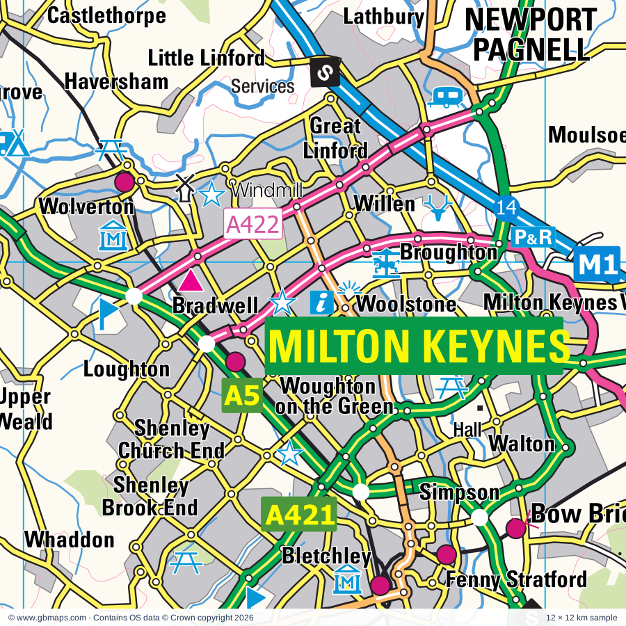
Milton Keynes regional road map. Full 60 × 60 km PDF, SVG and Illustrator files, with a free PDF sample.

GBMAPS.COM

Milton Keynes Regional Road Map

Call Us Now for Help01751 473136

GREAT BRITAIN ROAD ATLAS · 1:250,000 GB-480-0240

Milton Keynes & surrounding area

Explore the full 60 × 60 km Milton Keynes regional road map at 1:250,000, covering Bletchley, Buckingham, Winslow, Woburn Sands, Towcester. Compare the complete coverage below; a detailed PDF sample is available free.

MILTON KEYNES & SURROUNDING AREAREGIONAL ROAD MAP
60 × 60 km · Full map previewDownload the free SVG ↓

INSIDE THE FULL 60 × 60 KM MAP

Explore the Milton Keynes map area

1:250,000 cartography

Towns, villages & places

More mapped places (338)
  • Daventry
  • Calverton
  • Old Stratford
  • Cosgrove
  • Haversham
  • Beachampton
  • Castlethorpe
  • Potterspury
  • Wicken
  • Whaddon
  • Little Linford
  • Nash
  • Thornton
  • Hanslope
  • Leckhampstead
  • Gayhurst
  • Thornborough
  • Alderton
  • Tyringham
  • Lathbury
  • Akeley
  • Paulerspury
  • Ashton
  • Hartwell
  • Pury End
  • Sherington
  • Moulsoe
  • Filgrave
  • Mursley
  • Whittlebury
  • Adstock
  • Wavendon
  • Chicheley
  • Ravenstone
  • Bow Brickhill
  • Chackmore
  • Shutlanger
  • Padbury
  • Roade
  • Wood Burcote
  • Swanbourne
  • Addington
  • Emberton
  • Dadford
  • Salford
  • Courteenhall
  • Silverstone
  • Radclive
  • Hulcote
  • Piddington
  • Gawcott
  • Horton
  • Stewkley
  • Hoggeston
  • Hackleton
  • Bragenham
  • Soulbury
  • Granborough
  • Blisworth
  • Hardmead
  • Tiffield
  • Cranfield
  • Hillesden
  • Dunton
  • Tingewick
  • Shalstone
  • Abthorpe
  • Greens Norton
  • Collingtree
  • Duncote
  • Biddlesden
  • Bourne End
  • Botolph Claydon
  • Astwood
  • Warrington
  • Slapton
  • Syresham
  • Gayton
  • Bradden
  • Finmere
  • Lavendon
  • Cold Brayfield
  • Ridgmont
  • Burcott
  • Astcote
  • Cublington
  • Creslow
  • Potsgrove
  • Westbury
  • Wappenham
  • Eastcote
  • Denton
  • Crowfield
  • Oving
  • Chetwode
  • Rothersthorpe
  • Calvert
  • Turvey
  • Whitchurch
  • Lidlington
  • Pattishall
  • Wing
  • Whitfield
  • Twyford
  • Upper Shelton
  • Little Houghton
  • Battlesden
  • Pitchcott
  • Turweston
  • Mixbury
  • Grimscote
  • Charndon
  • Blakesley
  • Stagsden
  • Woodend
  • Godington
  • Quainton
  • Wood End
  • Hardwick
  • Cogenhoe
  • Ledburn
  • Poundon
  • Whiston
  • Bugbrooke
  • Millbrook
  • Radstone
  • Edgcott
  • Steppingley
  • Eggington
  • Helmdon
  • Carlton
  • Bozeat
  • Wingrave
  • Weston
  • Grendon
  • Weedon
  • Litchborough
  • Hockliffe
  • Stewartby
  • Kislingbury
  • Evenley
  • Tingrith
  • Chellington
  • Rowsham
  • Harrold
  • Cottisford
  • Fringford
  • Box End
  • Billington
  • West End
  • Maidford
  • Mentmore
  • Upper Stowe
  • Stevington
  • Stanbridge
  • Juniper Hill
  • Hethe
  • Slapton
  • Tebworth
  • Halse
  • Harpole
  • Adstone
  • Bromham
  • Tilsworth
  • Toddington
  • Waddesdon
  • Ecton
  • Kingswood
  • Hulcott
  • Farthingstone
  • Strixton
  • Horton
  • Odell
  • Wingfield
  • Westcott
  • Westoning
  • Hardwick
  • Bierton
  • Pavenham
  • Sulgrave
  • Greatworth
  • Oakley
  • Wollaston
  • Fancott
  • Harlington
  • Bainton
  • Hinwick
  • Flore
  • Weedon Bec
  • Maulden
  • Harlestone
  • Cheddington
  • Greenfield
  • Launton
  • Elstow
  • Stoke Lyne
  • Felmersham
  • Clapham
  • Boughton
  • Nobottle
  • Flitton
  • Farthinghoe
  • Croughton
  • Moulton
  • Overstone
  • Caversfield
  • Ludgershall
  • Culworth
  • Wilstead
  • Podington
  • Puttenham
  • Totternhoe
  • Chalton
  • Pulloxhill
  • Radwell
  • Edlesborough
  • Farndish
  • Everdon
  • Wilby
  • Milton Ernest
  • Blackthorn
  • Sywell
  • Charlton
  • Ashendon
  • Dodford
  • Piddington
  • Stone
  • Sharnbrook
  • Pitstone
  • Eydon
  • Sharpenhoe
  • Newbottle
  • Ivinghoe
  • Wilstone
  • Bucknell
  • Marsworth
  • Thenford
  • Brockhall
  • Dorton
  • Ambrosden
  • Pitsford
  • Shortstown
  • Harrowden
  • Irchester
  • Silsoe
  • Souldrop
  • Lower Winchendon
  • Bletsoe
  • Clophill
  • Ardley
  • Upton
  • Wymington
  • Buckland
  • Hinton
  • Souldern
  • Aynho
  • Streatley
  • Gibraltar
  • Dinton
  • Fritwell
  • Newnham
  • Bishopstone
  • Cuddington
  • Whilton
  • Holcot
  • Cardington
  • Brill
  • Holdenby
  • Haynes
  • Ravensden
  • Chesterton
  • Hardwick
  • Chearsley
  • Whipsnade
  • Dagnall
  • Renhold
  • Edgcote
  • Chilton
  • Badby
  • Charwelton
  • Norton
  • Knotting
  • East Haddon
  • Boarstall
  • Byfield
  • Ravensden
  • Thurleigh
  • Wendlebury
  • Holywell
  • Renhold
  • Long Buckby Wharf
  • Merton
  • Ringshall
  • Easington
  • Kensworth
  • Aldbury
  • Oakley
  • Murcott
  • Wigginton
  • Studham
  • Fencott
  • Caulcott
  • Caddington
  • Wilden
  • Riseley
  • Upper Catesby
  • Staverton
  • Hudnall
  • Hellidon
  • Welton
  • Yelden
  • Melchbourne
  • Caldecott
  • Bolnhurst
  • Watford
  • Chelveston
  • Oddington
  • Markyate
  • Jockey End
  • Keysoe
  • Swineshead
  • Nettleden
  • Braunston
  • Noke
  • Flecknoe
  • Beckley
  • Bletchingdon
  • Shelton
  • Flamstead
  • Islip
  • Pertenhall
  • Water End
  • Woodeaton
  • Willoughby
  • Sawbridge
  • Elsfield
  • Tilbrook
  • Kimbolton

Roads across this sheet

M1, M40, A6, A40, A41, A43, A45, A361, A413, A418, A421, A422, A425, A428, A505, A507, A508, A509, A510, A600, A603, A1081, A4010, A4012

More road numbers

A4095, A4146, A4156, A4157, A4165, A4251, A4256, A4280, A4421, A4500, A4501, A5001, A5028, A5076, A5095, A5101, A5120, A5123, A5128, A5130, A5134, A5140, A5141, A5183, A5193, A5199, A5228, B430, B486, B487, B488, B489, B526, B530, B531, B560, B565, B569, B570, B571, B572, B573, B579, B645, B655, B660, B663, B4009, B4011, B4027, B4030, B4031, B4032, B4033, B4034, B4036, B4037, B4038, B4100, B4443, B4506, B4525, B4540, B4541, B4635, B5346, B5383, B5385, B5388

Rivers & waterways

Grand Union Canal, Grand Union Canal (Wendover Arm), Grand Union Canal (disused), River Cherwell, River Flit, River Glyme, River Great Ouse, River Ise, River Kym, River Lea or Lee, River Nene, River Ouzel or Lovat

More waterways

River Ray, River Thame, River Til, River Tove

Landmarks & landscape

306th Bombardment Group Museum, Abington Museum, Althorp, Ascott House, Ascott House and Gardens, Ashridge College, Ashridge Visitor Centre, Aynho Park, Barnes Meadow Nature Reserve, Bedford Museum, Bunyan Meeting House and Bunyan Museum, Bernwood Forest Nature Reserve, Bird of Prey Centre

More named features

Bletchley Park, Boarstall Duck Decoy, Boarstall Tower, Bradwell Windmill, Brampton Valley Way, Brill Windmill, Brixworth Country Park, Brixworth Country Park Visitor Centre, Bromham Watermill, Buckinghamshire County Museum, Buckinghamshire Railway Centre, Burnums Farmyard Museum, Calvert Jubilee Nature Reserve, Canons Ashby, Castle Ashby Gardens, Catanger Farm, Catanger Llamas, Cathedral of Our Lady and St Thomas of Canterbury Martyr, Central Museum & Art Gallery, 78 Derngate (The Charles Rennie Mackintosh House and Galleries, Chichele College, Chilterns Gateway Centre, Claydon House, Craft Centre, Croyland Hall Heritage Centre, Wellingborough Museum, Daventry Country Park, De Grey Mausoleum, Delapre Abbey, Dunstable Downs Country Park, Earls Barton Museum, Elstow Moot Hall Museum, Emberton Country Park, Emberton Country Park Visitor Centre, Everdon Stubbs Woodland Trust Wood Nature Reserve, Felmersham Gravel Pits Nature Reserve, Flitton Moor Nature Reserve, Flitwick Moor Nature Reserve, Ford End Watermill, Glebe Farm Solar Energy Park, Glen Miller Museum, Go Ape Woburn, Great Denham Country Park, Gulliver's (Milton Keynes), Harrold Odell Country Park, Harrold-Odell Country Park Visitor Centre, Houghton House (remains of), Hunsbury Hill Country Park, Irchester Country Park with Visitor Centre, Irchester Narrow Gauge Railway Museum, John Dony Field Centre, Leighton Buzzard Light Railway, Long Buckby Castle, Luton Museum & Art Gallery, Marston Thrift Nature Reserve, Marston Vale Millennium Country Park, Marsworth Reservoir Nature Reserve, Mead Open Farm, Milton Keynes Museum, Model Farm, National Waterways Museum, Stoke Bruerne, Nether Winchendon House, North Brickhill Country Park, North Willen Park, Northampton & Lamport Railway (Preserved Railway), Northampton International Circuit, Northamptonshire Ironstone Railway Museum, Old Dairy Farm Centre, Old Gaol Museum, Park House, Pitstone Windmill, Pogs Crafts, Priory Country Park Visitor Centre, Quainton Windmill, Rookery Farm (Working Farm), Rowles Solar Farm, Rushden, Higham & Wellingborough, Rushmere Country Park, Santa Pod Raceway, Shacks Barn Solar Farm, Silverstone Motor Racing Circuit, Snakes and Ladders, Solar Farm, St James' Lake Nature Reserve, Stevington Windmill, Stockgrove Country Park, Stockwood Discovery Centre, Stony Stratford Nature Reserve, Stowe House, Stowe Landscape Gardens, Stowe School, Sulgrave Manor, Summer Leys Nature Reserve, Sundon Hills Country Park, Sywell Aviation Museum, Sywell Reservoir Country Park, The Cowper and Newton Museum, The Menagerie, The National Bowl, The Piazzi Smyth Observatory & Wolfson Planetarium, The Higgins Bedford Major Art Gallery, Thrift Farm Park, Thurleigh Farm Centre, Tiddenfoot Wildlife Park, Toddington Manor, Totternhoe Knolls Nature Reserve, Towcester Racecourse, Transport Museum, Rushden Museum, Tring Brewery, Visitor Centre, Waddesdon Manor, Waddesdon Manor and Garden, Walter Rothschild Zoological Museum, Walton Hall, Whilton Locks Pottery, Whilton Mill, Whipsnade White Lion (Hill Figure), Wilstone Reservoir Nature Reserve, Woburn Abbey, Woburn Heritage Centre, Woburn Safari Park, Wollaston Museum, Woodside Farm & Wild Fowl Park, Wrest Park, Xscape (Milton Keynes), ZSL Whipsnade Zoo
Local authority & parish coverage

Wholly or partly within the full map rectangle. These boundaries are coverage information, not additional artwork layers.

  • BedfordPartly within
  • BuckinghamshirePartly within
  • Central BedfordshirePartly within
  • Cherwell DistrictPartly within
  • Dacorum DistrictPartly within
  • Huntingdonshire DistrictPartly within
  • LutonPartly within
  • Milton KeynesWholly within
  • North Hertfordshire DistrictPartly within
  • North NorthamptonshirePartly within
  • Oxford DistrictPartly within
  • Rugby DistrictPartly within
  • South Oxfordshire DistrictPartly within
  • St. Albans DistrictPartly within
  • Stratford-on-Avon DistrictPartly within
  • West NorthamptonshirePartly within
Wards & electoral divisions 187 areas
  • Abington & Phippsville Ward
  • Aldbury and Wigginton Ward (part)
  • Ampthill Ward (part)
  • Ashridge Ward (part)
  • Aspley & Woburn Ward
  • Aston Clinton & Weston Turville Ward (part)
  • Aylesbury East Ward
  • Aylesbury North Ward
  • Aylesbury North West Ward
  • Aylesbury South East Ward
  • Aylesbury South West Ward
  • Aylesbury West Ward
  • Barnfield Ward
  • Barton-le-Clay & Silsoe Ward (part)
  • Beech Hill Ward
  • Berryfields, Buckingham Park & Watermead Ward
  • Bicester East Ward
  • Bicester North & Caversfield Ward
  • Bicester South & Ambrosden Ward
  • Bicester West Ward
  • Biddenham Ward
  • Bierton, Kingsbrook & Wing Ward
  • Billing Ward
  • Biscot Ward
  • Bishop's Itchington, Fenny Compton & Napton Ward (part)
  • Blackthorn & Rectory Farm Ward
  • Bletchley Park & Fenny Stratford Ward
  • Bletchley South Ward
  • Bletchley West Ward
  • Brackley Ward
  • Bradwell Ward
  • Bramingham Ward
  • Braunston & Crick Ward (part)
  • Brickhill & Queensway Ward
  • Brickhill Ward
  • Brixworth Ward (part)
  • Bromham Ward
  • Broughton & Moulsoe Ward
  • Buckingham Ward
  • Caddington Ward (part)
  • Campbell Park & Willen Ward
  • Campion Ward
  • Castle & Newnham Ward
  • Castle Ward
  • Cauldwell Ward
  • Central Milton Keynes Ward
  • Central Ward
  • Challney Ward
  • Clapham & Oakley Ward
  • Cogenhoe & The Houghtons Ward
  • Cranfield & Marston Moretaine Ward
  • Cropredy, Sibfords & Wroxton Ward (part)
  • Croyland & Swanspool Ward
  • Cutteslowe & Sunnymead Ward (part)
  • Dallington Spencer Ward
  • Dallow Ward
  • Danesborough Ward
  • Daventry North East Ward
  • Daventry North West Ward
  • Daventry South Ward
  • De Parys Ward
  • Deanshanger & Paulerspury Ward
  • Deddington Ward (part)
  • Dunstable Central Ward
  • Dunstable East Ward
  • Dunstable North Ward
  • Dunstable South Ward
  • Dunstable West Ward
  • Duston Ward
  • Earls Barton Ward (part)
  • Eaton Bray Ward
  • Far Cotton, Delapre & Briar Hill Ward
  • Farley Ward
  • Finedon Ward (part)
  • Flitwick Ward
  • Forest Hill & Holton Ward (part)
  • Fringford & Heyfords Ward (part)
  • Furzton Ward
  • Goldington Ward
  • Great Barford Ward (part)
  • Great Denham Ward
  • Great Linford Ward
  • Grendon Underwood & The Claydons Ward
  • Greyfriars Ward
  • Grovehill Ward (part)
  • Hackleton & Roade Ward
  • Haddenham & Stone Ward (part)
  • Hanslope Ward
  • Harpenden North & Rural Ward (part)
  • Harpur Ward
  • Harrold Ward
  • Hatton Park Ward (part)
  • Headlands Ward
  • Heath & Reach Ward
  • High Town Ward (part)
  • Higham Ferrers Ward (part)
  • Horwood Ward
  • Houghton Conquest & Haynes Ward (part)
  • Houghton Regis East Ward
  • Houghton Regis West Ward
  • Hunsbury Ward
  • Irchester Ward
  • Irthlingborough Ward (part)
  • Ivinghoe Ward
  • Kempston Central & East Ward
  • Kempston North Ward
  • Kempston South Ward
  • Kempston West Ward
  • Kidlington East Ward (part)
  • Kidlington West Ward (part)
  • Kimbolton Ward (part)
  • Kingsbrook Ward
  • Kingsley & Semilong Ward
  • Kingsthorpe North Ward
  • Kingsthorpe South Ward
  • Launton & Otmoor Ward (part)
  • Leagrave Ward
  • Leam Valley Ward (part)
  • Leighton-Linslade North Ward
  • Leighton-Linslade South Ward
  • Leighton-Linslade West Ward
  • Lewsey Ward
  • Long Buckby Ward (part)
  • Long Crendon Ward (part)
  • Meppershall & Shillington Ward (part)
  • Middleton Cheney Ward (part)
  • Moulton Ward
  • Naseby Ward (part)
  • Nene Valley Ward
  • New Bradwell Ward
  • Newport Pagnell Ward
  • Newton Longville Ward
  • Northchurch Ward (part)
  • Northwell Ward
  • Offa Ward (part)
  • Olney & Rural Ward
  • Ouzel Valley Ward
  • Parklands Ward
  • Pemberton Ward
  • Poets Ward
  • Putnoe Ward
  • Quainton Ward
  • Queens Park Ward
  • Raunds Ward (part)
  • Redbourn Ward (part)
  • Renhold & Ravensden Ward (part)
  • Riseley Ward (part)
  • Riverfield Ward
  • Round Green Ward (part)
  • Rural North East Ward (part)
  • Rural South Northamptonshire Ward (part)
  • Rushden Lakes Ward
  • Rushden South Ward
  • Saints Ward
  • Sharnbrook Ward
  • Shefford Ward (part)
  • Shortstown Ward (part)
  • South Ward (part)
  • Stony Stratford Ward
  • Stopsley Ward (part)
  • Sundon Park Ward
  • Talavera Ward
  • Tattenhoe Ward
  • Toddington Ward (part)
  • Towcester Ward
  • Tring Central Ward
  • Tring East Ward (part)
  • Tring West and Rural Ward (part)
  • Upton Ward
  • Vauxhall Ward (part)
  • Victoria Ward (part)
  • Waddesdon Ward (part)
  • Walton Ward
  • Watling Ward (part)
  • Watling Ward
  • Wendover, Halton & Stoke Mandeville Ward (part)
  • Weston Favell & Abington Vale Ward
  • Westoning, Flitton & Greenfield Ward
  • Winslow Ward
  • Wixams & Wilstead Ward
  • Wolvercote Ward (part)
  • Wolverton Ward
  • Woodford & Weedon Ward (part)
  • Woodhall Farm Ward (part)
  • Wootton & Kempston Rural Ward
  • Woughton & Fishermead Ward
  • Wyboston Ward (part)
Civil parishes & communities 486 areas
  • Abbey Hill CP
  • Abthorpe CP
  • Addington CP
  • Adstock CP
  • Adstone CP
  • Akeley CP
  • Aldbury CP
  • Alderton CP
  • Althorp CP
  • Ambrosden CP
  • Ampthill CP
  • Ardley CP
  • Arncott CP
  • Ashby St. Ledgers CP
  • Ashendon CP
  • Ashton CP
  • Aspley Guise CP
  • Aspley Heath CP
  • Aston Abbotts CP
  • Aston Clinton CP (part)
  • Aston Le Walls CP (part)
  • Astwood CP
  • Aylesbury CP
  • Aynho CP (part)
  • Badby CP
  • Barby CP (part)
  • Barton Hartshorn CP
  • Barton-le-Clay CP (part)
  • Battlesden CP
  • Beachampton CP
  • Beckley and Stowood CP (part)
  • Berryfields CP
  • Bicester CP
  • Biddenham CP
  • Biddlesden CP
  • Bierton CP
  • Billing CP
  • Billington CP
  • Blackthorn CP
  • Blakesley CP
  • Bletchingdon CP (part)
  • Bletchley and Fenny Stratford CP
  • Bletsoe CP
  • Blisworth CP
  • Boarstall CP
  • Bolnhurst and Keysoe CP (part)
  • Boughton CP
  • Bow Brickhill CP
  • Bozeat CP
  • Brackley CP
  • Bradden CP
  • Bradwell CP
  • Brafield on the Green CP
  • Braunston CP
  • Brickhill CP
  • Brill CP
  • Brington CP
  • Brixworth CP (part)
  • Brockhall CP
  • Brogborough CP
  • Bromham CP
  • Broughton Hamlet CP
  • Broughton and Milton Keynes CP
  • Buckingham CP
  • Buckingham Park CP
  • Buckland CP (part)
  • Bucknell CP
  • Bugbrooke CP
  • Byfield CP (part)
  • Caddington CP
  • Calvert Green CP
  • Calverton CP
  • Campbell Park CP
  • Campton and Chicksands CP (part)
  • Canons Ashby CP
  • Cardington CP (part)
  • Carlton and Chellington CP
  • Castle Ashby CP
  • Castlethorpe CP
  • Catesby CP
  • Caversfield CP
  • Central Milton Keynes CP
  • Chacombe CP (part)
  • Chalgrave CP
  • Chalton CP
  • Charlton-on-Otmoor CP
  • Charndon CP
  • Charwelton CP
  • Chearsley CP (part)
  • Cheddington CP
  • Chelveston cum Caldecott CP (part)
  • Chesterton CP
  • Chetwode CP
  • Chicheley CP
  • Chilton CP (part)
  • Chipping Warden and Edgcote CP (part)
  • Church with Chapel Brampton CP
  • Clapham CP
  • Clifton Reynes CP
  • Clophill CP (part)
  • Cogenhoe and Whiston CP
  • Cold Brayfield CP
  • Cold Higham CP
  • Coldharbour CP
  • Collingtree CP
  • Colmworth CP (part)
  • Cople CP (part)
  • Cosgrove CP
  • Cottisford CP
  • Cotton End CP (part)
  • Courteenhall CP
  • Covington CP (part)
  • Cranfield CP
  • Creslow CP
  • Crick CP (part)
  • Croughton CP
  • Cublington CP
  • Cuddington CP (part)
  • Culworth CP
  • Daventry CP
  • Dean and Shelton CP (part)
  • Deanshanger CP
  • Denton CP
  • Dinton-with-Ford and Upton CP (part)
  • Dodford CP
  • Dorton CP
  • Drayton Beauchamp CP (part)
  • Drayton Parslow CP
  • Dunstable CP
  • Dunton CP
  • Duston CP
  • Earls Barton CP
  • East Claydon CP
  • East Haddon CP (part)
  • East Hunsbury CP
  • Easton Maudit CP
  • Easton Neston CP
  • Eaton Bray CP
  • Ecton CP
  • Edgcott CP
  • Edlesborough CP
  • Eggington CP
  • Elsfield CP (part)
  • Elstow CP
  • Emberton CP
  • Evenley CP
  • Everdon CP
  • Eversholt CP
  • Eydon CP
  • Fairfields CP
  • Far Cotton and Delapre CP
  • Farthinghoe CP
  • Farthingstone CP
  • Fawsley CP
  • Felmersham CP
  • Fencott and Murcott CP
  • Finedon CP (part)
  • Finmere CP
  • Flamstead CP
  • Fleet Marston CP
  • Flitton and Greenfield CP
  • Flitwick CP
  • Flore CP
  • Foscott CP
  • Fringford CP
  • Fritwell CP
  • Gawcott with Lenborough CP
  • Gayhurst CP
  • Gayton CP
  • Godington CP
  • Gosford and Water Eaton CP (part)
  • Grafton Regis CP
  • Granborough CP
  • Grandborough CP (part)
  • Grange Park CP
  • Gravenhurst CP (part)
  • Great Barford CP (part)
  • Great Brickhill CP
  • Great Denham CP
  • Great Doddington CP
  • Great Gaddesden CP (part)
  • Great Harrowden CP (part)
  • Great Horwood CP
  • Great Houghton CP
  • Great Linford CP
  • Greatworth and Halse CP
  • Greens Norton CP
  • Grendon CP
  • Grendon Underwood CP
  • Hackleton CP
  • Haddenham CP (part)
  • Halton CP (part)
  • Hampton Gay and Poyle CP (part)
  • Hannington CP (part)
  • Hanslope CP
  • Hardingstone CP
  • Hardmead CP
  • Hardwick CP
  • Hardwick CP (part)
  • Hardwick with Tusmore CP
  • Hargrave CP (part)
  • Harlestone CP
  • Harlestone Manor CP
  • Harlington CP
  • Harpenden Rural CP (part)
  • Harpole CP
  • Harrold CP
  • Hartwell CP
  • Haversham-cum-Little Linford CP
  • Haynes CP (part)
  • Heath and Reach CP
  • Hellidon CP (part)
  • Helmdon CP
  • Hethe CP
  • Hexton CP (part)
  • Heyford Park CP
  • Higham Ferrers CP (part)
  • Hillesden CP
  • Hinton-in-the-Hedges CP
  • Hockliffe CP
  • Hoggeston CP
  • Hogshaw CP
  • Holcot CP (part)
  • Holdenby CP
  • Hollowell CP (part)
  • Horton-cum-Studley CP
  • Houghton Conquest CP
  • Houghton Regis CP
  • Hulcote and Salford CP
  • Hulcott CP
  • Hunsbury Meadows CP
  • Husborne Crawley CP
  • Hyde CP (part)
  • Irchester CP
  • Irthlingborough CP (part)
  • Islip CP
  • Ivinghoe CP
  • Kempston CP
  • Kempston Rural CP
  • Kensworth CP
  • Kents Hill and Monkston CP
  • Kidlington CP (part)
  • Kilsby CP (part)
  • Kimbolton CP (part)
  • Kings Sutton CP (part)
  • Kingsbrook CP
  • Kingsthorpe CP
  • Kingswood CP
  • Kirtlington CP (part)
  • Kislingbury CP
  • Knotting and Souldrop CP
  • Lathbury CP
  • Launton CP
  • Lavendon CP
  • Leckhampstead CP
  • Leighton-Linslade CP
  • Lidlington CP
  • Lilley CP (part)
  • Lillingstone Dayrell with Luffield Abbey CP
  • Lillingstone Lovell CP
  • Litchborough CP
  • Little Brickhill CP
  • Little Gaddesden CP
  • Little Horwood CP
  • Little Houghton CP
  • Little Staughton CP (part)
  • Long Buckby CP (part)
  • Long Crendon CP (part)
  • Loughton & Great Holm CP
  • Lower Heyford CP (part)
  • Ludgershall CP
  • Maidford CP
  • Maids Moreton CP
  • Markyate CP
  • Marsh Gibbon CP
  • Marston Moreteyne CP
  • Marston St. Lawrence CP
  • Marsworth CP
  • Maulden CP
  • Mears Ashby CP
  • Melchbourne and Yielden CP
  • Mentmore CP
  • Merton CP
  • Middle Claydon CP
  • Middleton Cheney CP (part)
  • Middleton Stoney CP
  • Millbrook CP
  • Milton Bryan CP
  • Milton Ernest CP
  • Milton Malsor CP
  • Mixbury CP
  • Moreton Pinkney CP
  • Moulsoe CP
  • Moulton CP
  • Mursley CP
  • Nash CP
  • Nether Heyford CP
  • Nether Winchendon CP
  • Nettleden with Potten End CP (part)
  • New Bradwell CP
  • Newbottle CP
  • Newnham CP
  • Newport Pagnell CP
  • Newton Blossomville CP
  • Newton Bromswold CP
  • Newton Longville CP
  • Newton Purcell with Shelswell CP
  • Noke CP
  • North Crawley CP
  • North Marston CP
  • Northampton CP
  • Northchurch CP (part)
  • Norton CP
  • Oakley CP (part)
  • Oakley CP
  • Oddington CP
  • Odell CP
  • Old Stratford CP
  • Old Woughton CP
  • Olney CP
  • Overstone CP
  • Oving CP
  • Padbury CP
  • Pattishall CP
  • Paulerspury CP
  • Pavenham CP
  • Pertenhall CP (part)
  • Piddington CP
  • Pitchcott CP
  • Pitsford CP
  • Pitstone CP
  • Podington CP
  • Potsgrove CP
  • Potterspury CP
  • Poundon CP
  • Preston Bissett CP
  • Preston Capes CP
  • Priors Marston CP (part)
  • Pulloxhill CP
  • Quainton CP
  • Quinton CP
  • Radclive-cum-Chackmore CP
  • Radstone CP
  • Ravensden CP
  • Ravensthorpe CP (part)
  • Ravenstone CP
  • Redbourn CP (part)
  • Renhold CP (part)
  • Ridgmont CP
  • Riseley CP
  • Roade CP
  • Rothersthorpe CP
  • Rushden CP
  • Shalstone CP
  • Sharnbrook CP
  • Shenley Brook End CP
  • Shenley Church End CP
  • Sherington CP
  • Shillington CP (part)
  • Shortstown CP
  • Shutlanger CP
  • Silsoe CP
  • Silverstone CP
  • Simpson and Ashland CP
  • Slapton CP
  • Slapton CP
  • Slip End CP
  • Somerton CP (part)
  • Soulbury CP
  • Souldern CP (part)
  • Spratton CP (part)
  • Stagsden CP
  • Stanbridge CP
  • Stanton St. John CP (part)
  • Stantonbury CP
  • Stanwick CP (part)
  • Staverton CP
  • Steeple Claydon CP
  • Steppingley CP
  • Stevington CP
  • Stewartby CP
  • Stewkley CP
  • Stoke Bruerne CP
  • Stoke Goldington CP
  • Stoke Hammond CP
  • Stoke Lyne CP
  • Stoke Mandeville CP (part)
  • Stone with Bishopstone and Hartwell CP (part)
  • Stony Stratford CP
  • Stowe CP
  • Stowe IX Churches CP
  • Stratton Audley CP
  • Streatley CP (part)
  • Strixton CP
  • Studham CP
  • Sulgrave CP
  • Sundon CP
  • Swanbourne CP
  • Swineshead CP
  • Syresham CP
  • Sywell CP (part)
  • Thenford CP
  • Thornborough CP
  • Thornton CP
  • Thorpe Mandeville CP
  • Thurleigh CP
  • Tiffield CP
  • Tilbrook CP (part)
  • Tilsworth CP
  • Tingewick CP
  • Tingrith CP
  • Toddington CP
  • Totternhoe CP
  • Towcester CP
  • Tring CP (part)
  • Tring Rural CP
  • Turvey CP
  • Turweston CP
  • Twyford CP
  • Tyringham and Filgrave CP
  • Upper Heyford CP (part)
  • Upper Heyford CP
  • Upper Winchendon CP
  • Upper and Lower Shuckburgh CP (part)
  • Upton CP
  • Waddesdon CP
  • Walton CP
  • Wappenham CP
  • Wardington CP (part)
  • Warkworth CP (part)
  • Warrington CP
  • Water Stratford CP
  • Watermead CP
  • Waterperry with Thomley CP (part)
  • Watford CP (part)
  • Wavendon CP
  • Weedon Bec CP
  • Weedon CP
  • Wellingborough CP (part)
  • Welton CP
  • Wendlebury CP
  • West Bletchley CP
  • West Haddon CP (part)
  • West Hunsbury CP
  • Westbury CP
  • Westcott CP
  • Weston Turville CP (part)
  • Weston Underwood CP
  • Weston and Weedon CP
  • Weston-on-the-Green CP
  • Westoning CP
  • Whaddon CP
  • Whilton CP
  • Whipsnade CP
  • Whitchurch CP
  • Whitehouse CP
  • Whitfield CP
  • Whittlebury CP
  • Wicken CP
  • Wigginton CP (part)
  • Wilby CP
  • Wilden CP (part)
  • Willington CP (part)
  • Willoughby CP
  • Wilshamstead CP
  • Wing CP
  • Wingrave with Rowsham CP
  • Winslow CP
  • Wixams CP
  • Woburn CP
  • Woburn Sands CP
  • Wolfhampcote CP (part)
  • Wollaston CP
  • Wolverton and Greenleys CP
  • Woodeaton CP
  • Woodend CP
  • Woodford cum Membris CP
  • Woodham CP
  • Wootton CP
  • Wootton CP
  • Worminghall CP (part)
  • Wotton Underwood CP
  • Woughton CP
  • Wymington CP
  • Yardley Gobion CP
  • Yardley Hastings CP

Source: the GBMaps road atlas, OS Boundary-Line and postcode mapping datasets. Source editions are being checked for publication. Unmarked boundary names are wholly within the sheet; “part” means the map edge crosses the area.

Place lists are selected from the map source, not a complete gazetteer. Named features describe the cartography; visitor facilities and opening status are not verified. The free sample covers only 12 × 12 km of this larger sheet.

INSIDE YOUR DOWNLOAD

A proper road map, in useful formats

Road classifications, towns and villages, railways, rivers, landscape detail and tourist symbols, brought together in the GBMaps regional road atlas style.

PDF filePDFSVG fileSVGAdobe Illustrator AI fileAi

PDF for the finished map. SVG and layered Illustrator artwork for adapting colours, adding your own information and preparing designs.

THE FINISHED SHEET

Designed for print and presentation

Map coverage
60 × 60 km
Sample coverage
12 × 12 km
Print layout
A3 landscape · enlarged 1:250k cartography
Sheet furniture
Border, scale bar, key & north arrow

A few useful details

What changes when I select another square?

Select a surrounding square to bring it into the centre and reveal the maps around it. Each square is a different 60 × 60 km map. The preview, free sample and selected download change together. Neighbouring sheets overlap by 30 km so you can choose the coverage that suits you.

Is the free sample a vector map?

The on-page detail is an SVG. The free download is a separate 12 × 12 km PDF with a link to the full map. Please retain its copyright credits and product link when sharing it.

Can I buy a larger combined map?

These downloads are individual ready-made sheets. Contact GBMaps if you need a larger combined area.

FREE PDF SAMPLE

Your free map sample

Your free 12 × 12 km sample includes a link back to this map, so you can return for the full area whenever you need it.

Download free PDF sample ↓

Get your Milton Keynes map

Map download bundle

£24.00including VATOne payment

Pay securely

One payment. Your map stays open.

Your map download

Your map files

Preparing your download…

Checking your private download link…

Your map downloads

Already bought a map?

Find the downloads from your purchases.

Enter the email address you used at checkout. We’ll email you a private link to your available map downloads.