Louth regional road map. Full 60 × 60 km PDF, SVG and Illustrator files, with a free PDF sample.

GBMAPS.COM

Louth Regional Road Map

Call Us Now for Help01751 473136

GREAT BRITAIN ROAD ATLAS · 1:250,000 GB-540-0390

Louth & surrounding area

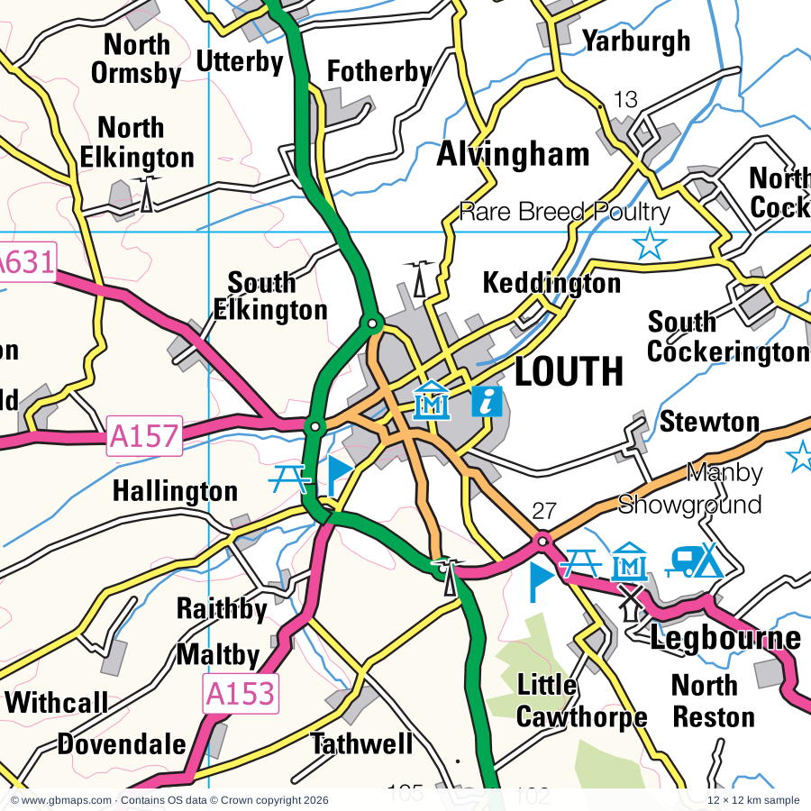
Explore the full 60 × 60 km Louth regional road map at 1:250,000, covering Louth, Mablethorpe, Cleethorpes, Spilsby, Horncastle. Compare the complete coverage below; a detailed PDF sample is available free.

LOUTH & SURROUNDING AREAREGIONAL ROAD MAP
60 × 60 km · Full map previewDownload the free SVG ↓

INSIDE THE FULL 60 × 60 KM MAP

Explore the Louth map area

1:250,000 cartography

Towns, villages & places

More mapped places (181)
  • Ludney
  • Yarburgh
  • Saltfleetby St Clement
  • Gayton le Marsh
  • Saltfleet
  • Legbourne
  • Grainthorpe
  • Tothill
  • Withern
  • Fotherby
  • Muckton
  • Authorpe
  • Eskham
  • Strubby
  • Utterby
  • Fulstow
  • Marshchapel
  • Maltby
  • Haugham
  • Tathwell
  • Hallington
  • Raithby
  • Burwell
  • Belleau
  • Aby
  • Beesby
  • North Cotes
  • Ludborough
  • Dovendale
  • Thorpe
  • Swaby
  • Saleby
  • White Pit
  • Trusthorpe
  • Withcall
  • Tetney Lock
  • Thoresthorpe
  • Ruckland
  • Tetney
  • Farforth
  • Markby
  • Sutton on Sea
  • Kelstern
  • Hannah
  • Alford
  • Bilsby
  • Grainsby
  • Cawkwell
  • Asserby
  • Oxcombe
  • Driby
  • Sandilands
  • Ulceby Cross
  • Brinkhill
  • Tetford
  • Well
  • Thurlby
  • Scamblesby
  • Farlesthorpe
  • Stenigot
  • Ulceby
  • Huttoft
  • Asterby
  • Mawthorpe
  • Humberston
  • Goulceby
  • Salmonby
  • Belchford
  • Somersby
  • Harrington
  • Bag Enderby
  • New Waltham
  • Brigsley
  • Fordington
  • Dalby
  • Swinhope
  • Willoughby
  • Binbrook
  • Anderby
  • Mumby
  • Fulletby
  • Langton
  • Cumberworth
  • Waltham
  • Aswardby
  • Ludford
  • Skendleby
  • Anderby Creek
  • Ranby
  • Brookenby
  • Thorganby
  • Sausthorpe
  • Benniworth
  • Hagworthingham
  • Greetham
  • Sloothby
  • Hatcliffe
  • Partney
  • Hogsthorpe
  • Scremby
  • Welton le Marsh
  • West Ashby
  • Sotby
  • Hainton
  • Hemingby
  • Croxby
  • Beelsby
  • Great Sturton
  • Low Toynton
  • Bradley
  • Lusby
  • High Toynton
  • Candlesby
  • Sixhills
  • Ashby by Partney
  • Baumber
  • Thoresway
  • Asgarby
  • Hameringham
  • Orby
  • Tealby
  • Edlington
  • Laceby
  • Halton Holegate
  • Hareby
  • Panton
  • Thimbleby
  • Cuxwold
  • Great Steeping
  • Addlethorpe
  • Hatton
  • Swallow
  • Kilnsea
  • West Barkwith
  • Bratoft
  • Aylesby
  • West Keal
  • Ingoldmells
  • Rothwell
  • Legsby
  • Walesby
  • Wispington
  • Minting
  • Miningsby
  • Langton
  • Thornton
  • Firsby
  • Healing
  • Riby
  • Moorby
  • Dalderby
  • Cabourne
  • East Kirkby
  • Gautby
  • Stallingborough
  • Easington
  • Skeffling
  • Roughton
  • Lissington
  • Horsington
  • Revesby
  • Haltham
  • Caistor
  • Croft
  • Kingthorpe
  • Keelby
  • Nettleton
  • Bucknall
  • Rand
  • Sunk Island
  • Apley
  • Stixwould
  • Stainfield
  • Brocklesby
  • Habrough
  • Bardney
  • Southrey
  • Kirmington
  • Sots Hole
  • Ulceby
  • Martin

Roads across this sheet

A16, A18, A46, A52, A111, A153, A155, A157, A158, A160, A180, A631, A1028, A1031, A1077, A1084, A1098, A1104, A1136, A1173, A1243, B1183, B1189, B1190

More road numbers

B1191, B1192, B1195, B1196, B1200, B1201, B1202, B1203, B1205, B1210, B1211, B1212, B1213, B1219, B1225, B1373, B1374, B1399, B1444, B1445, B1449, B1451, B1520, B1598

Rivers & waterways

CAR DYKE, Dales Head Dike, Great Eau, Hobhole Drain, Louth Canal, River Bain, River Freshney, River Witham, Steeping River, Timberland Delph, Wainfleet Haven or Steeping River

Landmarks & landscape

Alford Manor House, Alford Windmill, Anderby Drainage Museum, Aquarium, Bardney Abbey, Bardney Abbey (remains of), Bardney Heritage Centre, Barnovallum Gardens, Bolingbroke Castle, Bottons Pleasure Beach, Bradley Woods Nature Reserve, Bull Sand Fort

More named features

Cadwell Park, Caistor Arts and Heritage Centre, Chamber's Farm Wood Nature Reserve, Chamber's Farm Wood Visitor Centre, Chamber's Butterfly Garden, Church Farm Museum, Claythorpe Watermill and Wildfowl Gardens, Cleethorpes Coast Light Railway, Cleethorpes Country Park, Covenham Reservoir Nature Reserve, Craft Centre, Freshney Parkway Nature Reserve, Gayton Engine Pumping Station, Great Northern Railway, Gunby Hall, Haile Sand Fort, Hardy's Animal Farm, Humber Estuary Discovery Centre, Immingham Museum, Kids Adventure World, Lakeside Leisure, Legbourne Railway Museum, Lincolnshire Aviation Heritage Museum, Lincolnshire Coast Light Railway, Louth Museum, Normanby Park Farming Museum, Manby Showground, Market Rasen Racecourse, Motor Racing Circuit, Museum of Rural Life, National Fishing Heritage Centre, On Your Marques, Peasam Hill Nature Reserve, Pleasure Island Theme Park, RAF Wickenby Museum, Rand Farm Park, Red Hill Nature Reserve, Rushmoor Country Park Rare Breed Poultry, Saltfleetby and Theddlethorpe Dunes Nature Reserve, Seal Sanctuary, Skegness Lifeboat Museum, Skegness Model Village, Skegness Motor Racing Circuit (Stock Car), Snipe Dales Country Park, Spurn Bird Observatory, Spurn National Nature Reserve, St Mary's Church, Stockwith Mill, The Hollies Solar Farm, The Jungle, The Maguire Arboretum, The Pine Woods Nature Reserve, Thornton Abbey, Time Warp Discovery Centre, Newby Centre, Toby's Hill Nature Reserve, Tupholme Abbey, Tupholme Abbey (remains of), Waltham Windmill, Willoughby Branch Line WW and Cons Area Nature Reserve (Walkway and Conservation Area), Woodhall Spa Cottage Museum, Ye Old Curiosity Museum
Local authority & parish coverage

Wholly or partly within the full map rectangle. These boundaries are coverage information, not additional artwork layers.

  • East Lindsey DistrictPartly within
  • East Riding of YorkshirePartly within
  • North East LincolnshireWholly within
  • North Kesteven DistrictPartly within
  • North LincolnshirePartly within
  • West Lindsey DistrictPartly within
Wards & electoral divisions 64 areas
  • Alford Ward
  • Bardney Ward (part)
  • Billinghay Rural Ward (part)
  • Binbrook Ward
  • Branston Ward (part)
  • Burgh le Marsh Ward
  • Caistor and Yarborough Ward (part)
  • Chapel St. Leonards Ward
  • Coningsby & Mareham Ward (part)
  • Croft Baker Ward
  • Croft Ward (part)
  • Dunholme and Welton Ward (part)
  • East Marsh Ward
  • Ferry Ward (part)
  • Freshney Ward
  • Friskney Ward (part)
  • Fulstow Ward
  • Grimoldby Ward
  • Hagworthingham Ward
  • Halton Holegate Ward (part)
  • Haverstoe Ward
  • Heneage Ward
  • Holton-le-Clay & North Thoresby Ward
  • Horncastle Ward
  • Humberston and New Waltham Ward
  • Immingham Ward
  • Ingoldmells Ward
  • Kelsey Wold Ward (part)
  • Legbourne Ward
  • Mablethorpe Ward
  • Market Rasen Ward (part)
  • Marshchapel & Somercotes Ward
  • Metheringham Rural Ward (part)
  • North Holme Ward
  • Park Ward
  • Priory & St. James' Ward
  • Roughton Ward
  • Scarbrough & Seacroft Ward
  • Scartho Ward
  • Sibsey & Stickney Ward (part)
  • Sidney Sussex Ward
  • South East Holderness Ward (part)
  • South Ward
  • South West Holderness Ward (part)
  • Spilsby Ward
  • St. Clement's Ward
  • St. Margaret's Ward
  • St. Mary's Ward
  • St. Michael's Ward
  • Sutton on Sea Ward
  • Tetford & Donington Ward
  • Tetney Ward
  • Trinity Ward
  • Wainfleet Ward (part)
  • Waltham Ward
  • West Marsh Ward
  • Willoughby with Sloothby Ward
  • Winthorpe Ward
  • Withern & Theddlethorpe Ward
  • Wold View Ward (part)
  • Wolds Ward
  • Woodhall Spa Ward (part)
  • Wragby Ward
  • Yarborough Ward
Civil parishes & communities 257 areas
  • Aby with Greenfield CP
  • Addlethorpe CP
  • Alford CP
  • Alvingham CP
  • Anderby CP
  • Apley CP (part)
  • Ashby cum Fenby CP
  • Ashby with Scremby CP
  • Asterby CP
  • Aswardby CP
  • Authorpe CP
  • Aylesby CP
  • Bardney CP
  • Barnoldby Le Beck CP
  • Baumber CP
  • Beelsby CP
  • Beesby with Saleby CP
  • Belchford CP
  • Belleau CP
  • Benniworth CP
  • Bilsby CP
  • Binbrook CP
  • Blankney CP (part)
  • Bolingbroke CP
  • Brackenborough with Little Grimsby CP
  • Bradley CP
  • Branston and Mere CP (part)
  • Bratoft CP
  • Brigsley CP
  • Brinkhill CP
  • Brocklesby CP
  • Brookenby CP
  • Bucknall CP
  • Bullington CP (part)
  • Burgh Le Marsh CP
  • Burgh on Bain CP
  • Burwell CP
  • Cabourne CP
  • Caistor CP (part)
  • Calcethorpe with Kelstern CP
  • Candlesby with Gunby CP
  • Chapel St. Leonards CP
  • Claxby CP (part)
  • Claxby St. Andrew CP
  • Claxby with Moorby CP
  • Claythorpe CP
  • Conisholme CP
  • Covenham St. Bartholomew CP
  • Covenham St. Mary CP
  • Croft CP (part)
  • Croxton CP (part)
  • Cumberworth CP
  • Dalby CP
  • Donington on Bain CP
  • Dunston CP (part)
  • Easington CP (part)
  • East Barkwith CP
  • East Halton CP (part)
  • East Keal CP
  • East Kirkby CP (part)
  • East Ravendale CP
  • Eastville CP (part)
  • Edlington with Wispington CP
  • Elkington CP
  • Farlesthorpe CP
  • Firsby CP
  • Fotherby CP
  • Fulletby CP
  • Fulnetby CP (part)
  • Fulstow CP
  • Gautby CP
  • Gayton Le Marsh CP
  • Gayton Le Wold CP
  • Goltho CP
  • Goulceby CP
  • Goxhill CP (part)
  • Grainsby CP
  • Grainthorpe CP
  • Grasby CP (part)
  • Great Carlton CP
  • Great Coates CP
  • Great Limber CP (part)
  • Great Steeping CP
  • Great Sturton CP
  • Greetham with Somersby CP
  • Grimoldby CP
  • Habrough CP
  • Hagworthingham CP
  • Hainton CP
  • Hallington CP
  • Haltham CP
  • Halton Holegate CP
  • Hameringham CP
  • Hannah cum Hagnaby CP
  • Harrington CP
  • Hatcliffe CP
  • Hatton CP
  • Haugh CP
  • Haugham CP
  • Hawerby cum Beesby CP
  • Healing CP
  • Hemingby CP
  • High Toynton CP
  • Hogsthorpe CP
  • Holton Le Clay CP
  • Holton cum Beckering CP
  • Horncastle CP
  • Horsington CP
  • Humberston CP
  • Hundleby CP
  • Huttoft CP
  • Immingham CP
  • Ingoldmells CP
  • Irby CP
  • Irby in the Marsh CP
  • Keddington CP
  • Keelby CP
  • Kirkby on Bain CP
  • Kirmington CP (part)
  • Kirmond Le Mire CP
  • Laceby CP
  • Langton By Spilsby CP
  • Langton By Wragby CP
  • Langton CP
  • Legbourne CP
  • Legsby CP
  • Linwood CP (part)
  • Lissington CP (part)
  • Little Carlton CP
  • Little Cawthorpe CP
  • Little Steeping CP
  • Louth CP
  • Low Toynton CP
  • Ludborough CP
  • Ludford CP
  • Lusby with Winceby CP
  • Mablethorpe and Sutton CP
  • Maidenwell CP
  • Maltby Le Marsh CP
  • Manby CP
  • Mareham Le Fen CP (part)
  • Mareham on the Hill CP
  • Markby CP
  • Market Rasen CP (part)
  • Market Stainton CP
  • Marshchapel CP
  • Martin CP (part)
  • Mavis Enderby CP
  • Metheringham CP (part)
  • Middle Rasen CP (part)
  • Minting CP
  • Muckton CP
  • Mumby CP
  • Nettleton CP (part)
  • New Leake CP (part)
  • New Waltham CP
  • Nocton CP (part)
  • Normanby Le Wold CP
  • North Cockerington CP
  • North Cotes CP
  • North Killingholme CP (part)
  • North Ormsby CP
  • North Somercotes CP
  • North Thoresby CP
  • North Willingham CP
  • Orby CP
  • Osgodby CP (part)
  • Partney CP
  • Patrington CP (part)
  • Paull CP (part)
  • Potter Hanworth CP (part)
  • Raithby CP
  • Raithby cum Maltby CP
  • Ranby CP
  • Rand CP (part)
  • Reston CP
  • Revesby CP (part)
  • Riby CP
  • Rigsby with Ailby CP
  • Rothwell CP
  • Roughton CP
  • Saltfleetby CP
  • Sausthorpe CP
  • Scamblesby CP
  • Scrivelsby CP
  • Searby cum Owmby CP (part)
  • Sixhills CP
  • Skeffling CP (part)
  • Skegness CP
  • Skendleby CP
  • Skidbrooke with Saltfleet Haven CP
  • Sotby CP
  • South Cockerington CP
  • South Killingholme CP
  • South Ormsby cum Ketsby CP
  • South Somercotes CP
  • South Thoresby CP
  • South Willingham CP
  • Spilsby CP
  • Stainfield CP (part)
  • Stainton Le Vale CP
  • Stallingborough CP
  • Stenigot CP
  • Stewton CP
  • Stickford CP (part)
  • Stixwould and Woodhall CP
  • Strubby with Woodthorpe CP
  • Sunk Island CP (part)
  • Swaby CP
  • Swallow CP
  • Swinhope CP
  • Tathwell CP
  • Tattershall Thorpe CP (part)
  • Tealby CP
  • Tetford CP
  • Tetney CP
  • Theddlethorpe All Saints CP
  • Theddlethorpe St. Helen CP
  • Thimbleby CP
  • Thoresway CP
  • Thorganby CP
  • Thornton Curtis CP (part)
  • Thorpe St. Peter CP (part)
  • Timberland CP (part)
  • Toynton All Saints CP
  • Toynton St. Peter CP
  • Tumby CP (part)
  • Tupholme CP
  • Ulceby CP (part)
  • Ulceby with Fordington CP
  • Utterby CP
  • Waddingworth CP
  • Wainfleet All Saints CP (part)
  • Waithe CP
  • Walesby CP
  • Walmsgate CP
  • Waltham CP
  • Well CP
  • Welton Le Marsh CP
  • Welton Le Wold CP
  • Welwick CP (part)
  • West Ashby CP
  • West Barkwith CP
  • West Fen CP (part)
  • West Keal CP
  • West Ravendale CP
  • West Torrington CP
  • Wickenby CP (part)
  • Willoughby with Sloothby CP
  • Withcall CP
  • Withern with Stain CP
  • Wold Newton CP
  • Wood Enderby CP
  • Woodhall Spa CP (part)
  • Wragby CP
  • Wyham cum Cadeby CP
  • Yarburgh CP

Source: the GBMaps road atlas, OS Boundary-Line and postcode mapping datasets. Source editions are being checked for publication. Unmarked boundary names are wholly within the sheet; “part” means the map edge crosses the area.

Place lists are selected from the map source, not a complete gazetteer. Named features describe the cartography; visitor facilities and opening status are not verified. The free sample covers only 12 × 12 km of this larger sheet.

INSIDE YOUR DOWNLOAD

A proper road map, in useful formats

Road classifications, towns and villages, railways, rivers, landscape detail and tourist symbols, brought together in the GBMaps regional road atlas style.

PDF filePDFSVG fileSVGAdobe Illustrator AI fileAi

PDF for the finished map. SVG and layered Illustrator artwork for adapting colours, adding your own information and preparing designs.

THE FINISHED SHEET

Designed for print and presentation

Map coverage
60 × 60 km
Sample coverage
12 × 12 km
Print layout
A3 landscape · enlarged 1:250k cartography
Sheet furniture
Border, scale bar, key & north arrow

A few useful details

What changes when I select another square?

Select a surrounding square to bring it into the centre and reveal the maps around it. Each square is a different 60 × 60 km map. The preview, free sample and selected download change together. Neighbouring sheets overlap by 30 km so you can choose the coverage that suits you.

Is the free sample a vector map?

The on-page detail is an SVG. The free download is a separate 12 × 12 km PDF with a link to the full map. Please retain its copyright credits and product link when sharing it.

Can I buy a larger combined map?

These downloads are individual ready-made sheets. Contact GBMaps if you need a larger combined area.

FREE PDF SAMPLE

Your free map sample

Your free 12 × 12 km sample includes a link back to this map, so you can return for the full area whenever you need it.

Download free PDF sample ↓

Get your Louth map

Map download bundle

£24.00including VATOne payment

Pay securely

One payment. Your map stays open.

Your map download

Your map files

Preparing your download…

Checking your private download link…

Your map downloads

Already bought a map?

Find the downloads from your purchases.

Enter the email address you used at checkout. We’ll email you a private link to your available map downloads.