Lancaster regional road map. Full 60 × 60 km PDF, SVG and Illustrator files, with a free PDF sample.

GBMAPS.COM

Lancaster Regional Road Map

Call Us Now for Help01751 473136

GREAT BRITAIN ROAD ATLAS · 1:250,000 GB-330-0450

Lancaster & surrounding area

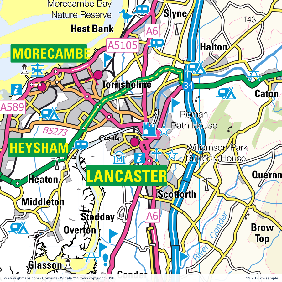
Explore the full 60 × 60 km Lancaster regional road map at 1:250,000, covering Preston, Cleveleys, Thornton, Heysham, Garstang. Compare the complete coverage below; a detailed PDF sample is available free.

LANCASTER & SURROUNDING AREAREGIONAL ROAD MAP
60 × 60 km · Full map previewDownload the free SVG ↓

INSIDE THE FULL 60 × 60 KM MAP

Explore the Lancaster map area

1:250,000 cartography

Towns, villages & places

More mapped places (100)
  • Whin Lane End
  • Singleton
  • Staining
  • Middleton
  • Glasson
  • Overton
  • Roa Island
  • Cockerham
  • Elswick
  • Nateby
  • Rampside
  • Winmarleigh
  • Weeton
  • Heaton
  • Roseacre
  • Esprick
  • Crossmoor
  • Stodday
  • Roosebeck
  • Forton
  • Galgate
  • Biggar
  • Churchtown
  • Newbiggin
  • Westby
  • Wharles
  • Leece
  • Inskip
  • Bowgreave
  • Wesham
  • Aldingham
  • Catterall
  • Gleaston
  • Moss Side
  • Dendron
  • Street
  • Treales
  • Baycliff
  • Scales
  • Catforth
  • Newton
  • Bilsborrow
  • Calder Vale
  • Hest Bank
  • Oakenclough
  • Quernmore
  • Slyne
  • Swillbrook
  • Quernmore
  • Claughton
  • Bardsea
  • Barton
  • Halton
  • Woodplumpton
  • Clifton
  • Ravenstown
  • Cottam
  • Inglewhite
  • Flookburgh
  • Abbeystead
  • Broughton
  • Whitechapel
  • Cark
  • Swarthmoor
  • Caton
  • Pennington
  • Marton
  • Allithwaite
  • Holker
  • Crossgill
  • Goosnargh
  • Marshaw
  • Tarnbrook
  • Silverdale
  • Over Kellet
  • Cartmel
  • Warton
  • Aughton
  • Hutton
  • Banks
  • Claughton
  • Capernwray
  • Haverigg
  • Farleton
  • Borwick
  • Grimsargh
  • Arnside
  • Tarleton
  • Gressingham
  • Hornby
  • Bretherton
  • Elston
  • Beetham
  • Arkholme
  • Clawthorpe
  • Holme
  • Melling
  • Newton
  • Brindle
  • Whittington

Roads across this sheet

M6, M55, M61, M65, A6, A49, A59, A65, A565, A582, A583, A584, A585, A586, A587, A588, A589, A590, A595, A601(M), A674, A675, A683, A5071

More road numbers

A5072, A5073, A5083, A5085, A5087, A5099, A5105, A5230, A6063, A6070, B5124, B5192, B5233, B5244, B5247, B5248, B5253, B5254, B5256, B5257, B5258, B5259, B5260, B5261, B5262, B5263, B5264, B5265, B5266, B5267, B5268, B5269, B5270, B5271, B5272, B5273, B5274, B5275, B5277, B5278, B5281, B5282, B5290, B5293, B5321, B5377, B5390, B5409, B5410, B5411, B5412, B5439, B6228, B6229, B6230, B6241, B6242, B6243, B6254, B6258, B6384, B6430, B6480

Rivers & waterways

Lancaster Canal, Lancaster Canal (Glasson Branch), Leeds & Liverpool Canal, Leeds & Liverpool Canal (Walton Summit Branch), Millennium Ribble Link, River Brock, River Calder, River Conder, River Darwen, River Douglas, River Greta, River Hindburn

More waterways

River Keer, River Lune, River Ribble, River Wenning, River Winster, River Wyre

Landmarks & landscape

Beacon Fell Country Park, Beacon Fell Country Park Visitor Centre, Blackpool Lifeboat Station Visitor Centre, Blackpool Pleasure Beach, Blackpool Sea Centre, Blackpool Tower, Blackpool Tower, Madame Tussards Blackpool, Blackpool Tramway, Blackpool Zoo, Bow Bridge, Brockholes Visitor Centre, Carnforth Railway Station Visitor Centre, LAKE DISTRICT NATIONAL PARK

More named features

Cartmel Priory Gatehouse, Cartmel Racecourse, Cobble Hey Farm and Gardens, Cuerden Valley Park, Cumbria Crystal, Dalton Castle, Dewlay Cheese, Docker Park Farm, Duckys Farm Park, Farmer Parrs Rare Breeds Farm, Freeport Outlet Village, Furness Abbey (remains of), Gait Barrows Nature Reserve, Gleaston Watermill, Greenlands Farm Village, Hall, Harris Museum and Art Gallery, The Football Museum Deepdale Preston, Yeomanry and County Museum, Heron Corn Mill, Heysham Nuclear Power Station Nature Reserve, Hoddbarrow Lake Nature Reserve, Holker Hall, Holker Hall Gardens, Humphre Head Nature Reserve, Jacinta Trawler Museum, Kaye's Tea Room and Nursery Garden, Lakeland Miniature Village, Lancaster Castle, Lancaster Cathedral, Leighton Hall, Leighton Moss Nature Reserve, Leighton Moss Visitor Centre, Longton Brickcroft Nature Reserve, Longton Brickcroft Nature Reserve Visitor Centre, Lower Heysham Heritage Centre, Lytham Hall, Lytham St Anne's Local Nature Reserve, Maritime Museum, The Judges' Lodgings, Cottage Museum, City Museum, Marsh Mill, Marshside Nature Reserve, Meditation Centre, Morecambe Bay Nature Reserve, Morecambe Leisure Park, Taylors Fun Fair, Museum of Queen's Lancashire, North Walney Nature Reserve, Oasis Wildlife Centre, Parachute Centre, Piel Castle, Pine Lake, Rectory, Ribble Discovery Centre, Fairhaven Lake, Ribble Steam Railway, Roman Bath House and Wery Way (remains of), Sandscale Haws Nature Reserve, South Lakes Wild Animal Park, South Ribble Museum and Exhibition Centre, The British Commercial Vehicle Museum, South Walney Nature Reserve, Story of Scouting Museum, Swarthmoor Hall, The Dock Museum, The Dolls House and Fleetwood Museum, The Laurel & Hardy Museum, Classic Bikes Working Museum, The West Lancashire Light Railway, Warton Crag Nature Reserve, Warton Old Rectory, Williamson Park, Butterfly House, Windmill Museum, Lytham Lifeboat Museum, Lytham Heritage Centre, Worden Park, Wyre Estuary Country Park, Wyre and Lune Sanctuary, Wyreside Ecology Centre
Local authority & parish coverage

Wholly or partly within the full map rectangle. These boundaries are coverage information, not additional artwork layers.

  • BlackpoolWholly within
  • Chorley DistrictPartly within
  • CumberlandPartly within
  • Fylde DistrictWholly within
  • Lancaster DistrictPartly within
  • Preston DistrictPartly within
  • Ribble Valley DistrictPartly within
  • Sefton DistrictPartly within
  • South Ribble DistrictPartly within
  • West Lancashire DistrictPartly within
  • Westmorland and FurnessPartly within
  • Wyre DistrictWholly within
Wards & electoral divisions 160 areas
  • Alston & Hothersall Ward (part)
  • Anchorsholme Ward
  • Ansdell & Fairhaven Ward
  • Ashton Ward
  • Ashton Ward
  • Bamber Bridge East Ward
  • Bamber Bridge West Ward
  • Bare Ward
  • Bispham Ward
  • Bloomfield Ward
  • Bolton & Slyne Ward
  • Bourne Ward
  • Bowerham Ward
  • Bowness and Lyth Ward (part)
  • Breck Ward
  • Broad Oak Ward
  • Broadfield Ward
  • Brock with Catterall Ward
  • Brookfield Ward
  • Brunswick Ward
  • Buckshaw & Whittle Ward (part)
  • Buckshaw & Worden Ward
  • Bulk Ward
  • Burscough Bridge & Rufford Ward (part)
  • Burton and Holme Ward (part)
  • Cadley Ward
  • Calder Ward
  • Cambridge Ward (part)
  • Carleton Ward
  • Carnegie Ward
  • Carnforth & Millhead Ward
  • Castle Ward
  • Charnock Ward
  • Chipping Ward (part)
  • Chorley North & Astley Ward (part)
  • Chorley North East Ward (part)
  • City Centre Ward
  • Claremont Ward
  • Clayton East, Brindle & Hoghton Ward (part)
  • Clayton West & Cuerden Ward
  • Cleveleys Park Ward
  • Clifton Ward
  • Coupe Green & Gregson Lane Ward (part)
  • Croston, Mawdesley & Euxton South Ward (part)
  • Dalton North Ward (part)
  • Dalton South Ward
  • Deepdale Ward
  • Derby & Thornley Ward (part)
  • Earnshaw Bridge Ward
  • Ellel Ward (part)
  • Euxton Ward (part)
  • Farington East Ward
  • Farington West Ward
  • Fishwick & Frenchwood Ward
  • Freckleton Village Ward
  • Garrison Ward
  • Garstang Ward
  • Grange and Cartmel Ward (part)
  • Great Eccleston Ward
  • Greenlands Ward
  • Greyfriars Ward
  • Halton-with-Aughton & Kellet Ward (part)
  • Hambleton & Stalmine Ward
  • Hardhorn with High Cross Ward
  • Hawcoat and Newbarns Ward
  • Hawes Side Ward
  • Heyhouses Ward
  • Heysham Central Ward
  • Heysham North Ward
  • Heysham South Ward
  • High Furness Ward (part)
  • Highfield Ward
  • Hoole Ward
  • Howick & Priory Ward
  • Ingol & Cottam Ward
  • Ingthorpe Ward
  • John O'Gaunt Ward
  • Jubilee Ward
  • Kent Estuary Ward (part)
  • Kilgrimol Ward
  • Kilnhouse Ward
  • Kirkham Ward
  • Layton Ward
  • Lea & Larches Ward
  • Leyland Central Ward
  • Longton & Hutton West Ward
  • Lostock Hall Ward
  • Low Furness Ward
  • Lower Lune Valley Ward (part)
  • Lytham East Ward
  • Lytham West Ward
  • Marsh Mill Ward
  • Marsh Ward
  • Marton Ward
  • Medlar-with-Wesham Ward
  • Meols Ward (part)
  • Middleforth Ward
  • Millom Ward (part)
  • Millom Without Ward (part)
  • Moss Side Ward
  • Mount Ward
  • New Longton & Hutton East Ward
  • Norbreck Ward
  • North Meols & Hesketh Bank Ward (part)
  • Old Barrow and Hindpool Ward
  • Ormsgill and Parkside Ward
  • Overton Ward
  • Park Ward
  • Park Ward
  • Park Ward
  • Pharos Ward
  • Pheasant's Wood Ward
  • Pilling Ward
  • Plungington Ward
  • Poulton Ward
  • Preesall Ward
  • Preston Rural East Ward (part)
  • Preston Rural North Ward
  • Ribbleton Ward
  • Risedale and Roosecote Ward
  • Rossall Ward
  • Rural East Fylde Ward
  • Rural North Fylde Ward
  • Samlesbury & Walton Ward (part)
  • Scale Hall Ward
  • Scotforth East Ward
  • Scotforth West Ward
  • Sedbergh and Kirkby Lonsdale Ward (part)
  • Seven Stars Ward (part)
  • Sharoe Green Ward
  • Silverdale Ward
  • Skerton Ward
  • Squires Gate Ward
  • St. Ambrose Ward
  • St. Matthew's Ward
  • Staining Ward
  • Stanah Ward
  • Stanley Ward
  • Talbot Ward
  • Tarleton Village Ward (part)
  • Tithebarn Ward
  • Torrisholme Ward
  • Tyldesley Ward
  • Ulverston Ward
  • University Ward
  • Upper Lune Valley Ward (part)
  • Victoria & Norcross Ward
  • Victoria Ward
  • Walney Island Ward
  • Walton-le-Dale East Ward
  • Walton-le-Dale West Ward
  • Warbreck Ward
  • Warren Ward
  • Warton Ward
  • Warton Ward
  • Waterloo Ward
  • West End Ward
  • Westgate Ward
  • Wrea Green with Westby Ward
  • Wyresdale Ward
Civil parishes & communities 131 areas
  • Aldcliffe-with-Stodday CP
  • Aldingham CP
  • Ansdell CP
  • Arkholme-with-Cawood CP (part)
  • Arnside CP
  • Askam and Ireleth CP (part)
  • Barnacre-with-Bonds CP
  • Barrow CP
  • Barton CP
  • Beetham CP (part)
  • Bleasdale CP
  • Bolton-le-Sands CP
  • Borwick CP
  • Bowland Forest High CP (part)
  • Bretherton CP (part)
  • Brindle CP (part)
  • Broughton CP
  • Broughton East CP (part)
  • Bryning-with-Warton CP
  • Burton-in-Kendal CP
  • Cabus CP
  • Carnforth CP
  • Caton-with-Littledale CP (part)
  • Catterall CP
  • Chipping CP (part)
  • Claughton CP
  • Claughton CP
  • Clayton-le-Woods CP
  • Cockerham CP
  • Cuerdale CP
  • Cuerden CP
  • Dalton Town with Newton CP
  • Egton with Newland CP (part)
  • Ellel CP
  • Elswick CP
  • Euxton CP (part)
  • Farington CP
  • Fleetwood CP
  • Forton CP
  • Freckleton CP
  • Garstang CP
  • Goosnargh CP
  • Grange-Over-Sands CP (part)
  • Great Eccleston CP
  • Greenhalgh-with-Thistleton CP
  • Gressingham CP
  • Grimsargh CP (part)
  • Haighton CP
  • Halton-with-Aughton CP
  • Hambleton CP
  • Heapey CP (part)
  • Heaton-with-Oxcliffe CP
  • Hesketh-with-Becconsall CP
  • Hoghton CP (part)
  • Holme CP (part)
  • Hornby-with-Farleton CP (part)
  • Hutton CP
  • Hutton Roof CP (part)
  • Ingol and Tanterton CP
  • Inskip-with-Sowerby CP
  • Kirkby Ireleth CP (part)
  • Kirkby Lonsdale CP (part)
  • Kirkham CP
  • Kirkland CP
  • Lea CP
  • Lindal and Marton CP
  • Lindale and Newton-in-Cartmel CP (part)
  • Little Eccleston-with-Larbreck CP
  • Little Hoole CP
  • Longridge CP (part)
  • Longton CP
  • Lower Allithwaite CP (part)
  • Lower Holker CP
  • Lupton CP (part)
  • Lytham CP
  • Mansriggs CP (part)
  • Medlar-with-Wesham CP
  • Melling-with-Wrayton CP (part)
  • Middleton CP
  • Millom CP (part)
  • Morecambe CP
  • Much Hoole CP
  • Myerscough and Bilsborrow CP
  • Nateby CP
  • Nether Kellet CP
  • Nether Wyresdale CP
  • Newton-with-Clifton CP
  • North Meols CP (part)
  • Osmotherley CP (part)
  • Out Rawcliffe CP
  • Over Kellet CP
  • Over Wyresdale CP (part)
  • Overton CP
  • Pennington CP (part)
  • Penwortham CP
  • Pilling CP
  • Preesall CP
  • Priest Hutton CP
  • Quernmore CP
  • Ribby-with-Wrea CP
  • Roeburndale CP (part)
  • Saint Anne's on the Sea CP
  • Samlesbury CP (part)
  • Scotforth CP
  • Silverdale CP
  • Singleton CP
  • Slyne-with-Hest CP
  • Staining CP
  • Stalmine-with-Staynall CP
  • Tarleton CP (part)
  • Tatham CP (part)
  • The Yealands CP
  • Thornley-with-Wheatley CP (part)
  • Thurnham CP
  • Treales, Roseacre and Wharles CP
  • Tunstall CP (part)
  • Ulnes Walton CP (part)
  • Ulverston CP
  • Upper Rawcliffe-with-Tarnacre CP
  • Urswick CP
  • Warton CP
  • Weeton-with-Preese CP
  • Westby-with-Plumptons CP
  • Whicham CP (part)
  • Whittingham CP (part)
  • Whittington CP (part)
  • Whittle-le-Woods CP (part)
  • Winmarleigh CP
  • Witherslack, Meathop and Ulpha CP (part)
  • Woodplumpton CP
  • Wray-with-Botton CP (part)

Source: the GBMaps road atlas, OS Boundary-Line and postcode mapping datasets. Source editions are being checked for publication. Unmarked boundary names are wholly within the sheet; “part” means the map edge crosses the area.

Place lists are selected from the map source, not a complete gazetteer. Named features describe the cartography; visitor facilities and opening status are not verified. The free sample covers only 12 × 12 km of this larger sheet.

INSIDE YOUR DOWNLOAD

A proper road map, in useful formats

Road classifications, towns and villages, railways, rivers, landscape detail and tourist symbols, brought together in the GBMaps regional road atlas style.

PDF filePDFSVG fileSVGAdobe Illustrator AI fileAi

PDF for the finished map. SVG and layered Illustrator artwork for adapting colours, adding your own information and preparing designs.

THE FINISHED SHEET

Designed for print and presentation

Map coverage
60 × 60 km
Sample coverage
12 × 12 km
Print layout
A3 landscape · enlarged 1:250k cartography
Sheet furniture
Border, scale bar, key & north arrow

A few useful details

What changes when I select another square?

Select a surrounding square to bring it into the centre and reveal the maps around it. Each square is a different 60 × 60 km map. The preview, free sample and selected download change together. Neighbouring sheets overlap by 30 km so you can choose the coverage that suits you.

Is the free sample a vector map?

The on-page detail is an SVG. The free download is a separate 12 × 12 km PDF with a link to the full map. Please retain its copyright credits and product link when sharing it.

Can I buy a larger combined map?

These downloads are individual ready-made sheets. Contact GBMaps if you need a larger combined area.

FREE PDF SAMPLE

Your free map sample

Your free 12 × 12 km sample includes a link back to this map, so you can return for the full area whenever you need it.

Download free PDF sample ↓

Get your Lancaster map

Map download bundle

£24.00including VATOne payment

Pay securely

One payment. Your map stays open.

Your map download

Your map files

Preparing your download…

Checking your private download link…

Your map downloads

Already bought a map?

Find the downloads from your purchases.

Enter the email address you used at checkout. We’ll email you a private link to your available map downloads.