Kirkby Stephen regional road map. Full 60 × 60 km PDF, SVG and Illustrator files, with a free PDF sample.

GBMAPS.COM

Kirkby Stephen Regional Road Map

Call Us Now for Help01751 473136

GREAT BRITAIN ROAD ATLAS · 1:250,000 RY-15

Kirkby Stephen & surrounding area

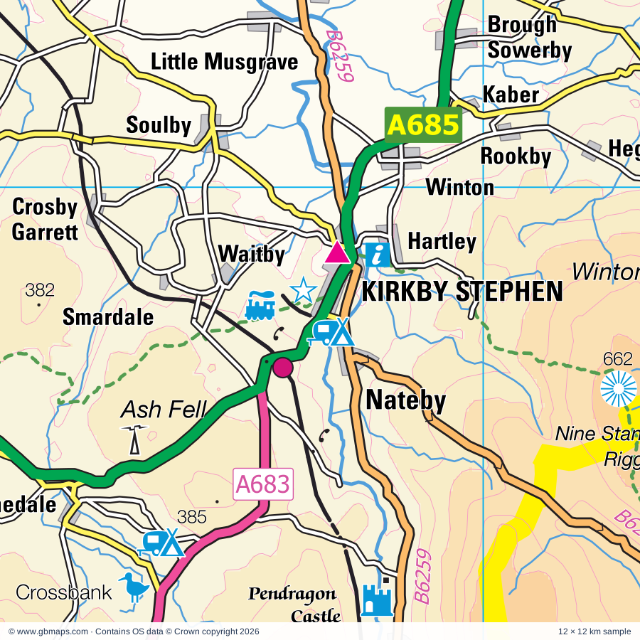
Explore the full 60 × 60 km Kirkby Stephen regional road map at 1:250,000, covering Brough, Kirkby Stephen, Richmond, Sedbergh, Crook. Compare the complete coverage below; a detailed PDF sample is available free.

KIRKBY STEPHEN & SURROUNDING AREAREGIONAL ROAD MAP
60 × 60 km · Full map previewDownload the free SVG ↓

INSIDE THE FULL 60 × 60 KM MAP

Explore the Kirkby Stephen map area

1:250,000 cartography

Towns, villages & places

More mapped places (201)
  • Kelton
  • Hury
  • Brough
  • Hartley
  • Winton
  • Helbeck
  • Grassholme
  • Thwaite
  • Muker
  • Ivelet
  • Nateby
  • Gunnerside
  • Langthwaite
  • Thringarth
  • Lartington
  • Hunderthwaite
  • Boldron
  • Little Musgrave
  • Bowbank
  • Outhgill
  • Feetham
  • Low Row
  • Kearton
  • Cotherstone
  • Waitby
  • Soulby
  • Scargill
  • Crackpot
  • Romaldkirk
  • Mickleton
  • Startforth
  • Smardale
  • Healaugh
  • Warcop
  • Hurst
  • Washfold
  • Brignall
  • Holwick
  • Eggleston
  • Bleatarn
  • Cotterdale
  • Reeth
  • Newbiggin
  • Sandford
  • Barningham
  • Ravenstonedale
  • Grinton
  • Sedbusk
  • Stainton
  • Greta Bridge
  • Hardraw
  • Kinninvie
  • Newbiggin
  • Askrigg
  • Appersett
  • Hilton
  • Bainbridge
  • Ettersgill
  • Little Asby
  • Hawes
  • Newsham
  • Thorpe
  • Worton
  • Burtersett
  • Murton
  • Gayle
  • Whorlton
  • Woodhall
  • Smallways
  • Skelton
  • Marrick
  • Dalton
  • Langdon Beck
  • Weasdale
  • Countersett
  • Great Asby
  • Wycliffe
  • Lane Head
  • Castle Bolton
  • Marske
  • Gayles
  • Bowderdale
  • Carperby
  • Drybeck
  • Burrells
  • Cleatlam
  • Ovington
  • Hoff
  • Redmire
  • Marsett
  • Woodland
  • Aysgarth
  • Sunbiggin
  • Stalling Busk
  • Kirby Hill
  • Ravensworth
  • Copley
  • Kelleth
  • Stainton
  • Downholme
  • Winston
  • Garsdale
  • Whashton
  • Staindrop
  • Swinithwaite
  • Thoralby
  • Dufton
  • Raisbeck
  • Colby
  • Hudswell
  • Cautley
  • Brampton
  • Butterknowle
  • Newbiggin
  • East Layton
  • Caldwell
  • Gaisgill
  • Cockfield
  • Crackenthorpe
  • West Witton
  • Redford
  • Cowgill
  • Hartforth
  • Bellerby
  • Forcett
  • Orton
  • Gainford
  • Eppleby
  • St John's Chapel
  • Wensley
  • Westgate
  • Wackerfield
  • Knock
  • Hill End
  • Langton
  • Tebay
  • Oughtershaw
  • Walden
  • Ireshopeburn
  • Morley
  • Hilton
  • Eastgate
  • Ingleton
  • Bolton
  • Headlam
  • Bedburn
  • Evenwood
  • Frosterley
  • Wearhead
  • Beckermonds
  • Melsonby
  • Barden
  • Agglethorpe
  • Hamsterley
  • Dent
  • Carlton
  • Harmby
  • Melmerby
  • Millthrop
  • Reagill
  • Gawthrop
  • Killerby
  • Milburn
  • Gammersgill
  • Deepdale
  • Coverham
  • Lowgill
  • Caldbergh
  • West Scrafton
  • Spennithorne
  • Firbank
  • Swineside
  • Horsehouse
  • Bolam
  • Braidley
  • Newbiggin
  • Hunton
  • Blencarn
  • Kirkland
  • Witton Park
  • Finghall
  • Thornley
  • High Grange
  • Culgaith
  • Escomb
  • Killington
  • Middleton
  • Skirwith
  • Colsterdale
  • Hunwick
  • Roddymoor
  • Sunniside
  • Ousby
  • Ellingstring
  • Stanley Crook
  • Barbon
  • Melmerby
  • Mansergh
  • Healey
  • Fearby
  • Gamblesby

Roads across this sheet

M6, A67, A68, A683, A684, A685, A686, A688, A689, A690, A6108, A6136, B6160, B6254, B6255, B6256, B6257, B6259, B6260, B6261, B6270, B6271, B6274, B6276

More road numbers

B6277, B6278, B6279, B6281, B6282, B6284, B6286, B6296, B6297, B6298, B6299, B6301, B6412, B6542

Rivers & waterways

Birk Beck, Bishopdale Beck, Black Beck, Black Burn, Borrow Beck, Cam Beck, Crowdundle Beck, Harwood Beck, Leck Beck, River Cover, River Eden, River Gaunless

More waterways

River Greta, River Lune, River Lyvennet, River Ribble, River South Tyne, River Swale, River Tees, River Ure, River Wear, River Wharfe

Landmarks & landscape

Abbey, Acorn Bank Garden & Water Mill, Appersett Viaduct, Appleby Castle, Arten Gill Viaduct, Aske Hall, Aysgarth Falls, Barnard Castle, Barnard Castle, Barnard Castle Sensory Garden, Bolton Castle, Bolton Hall, Bowes Castle, YORKSHIRE DALES NATIONAL PARK

More named features

Bowlees Visitor Centre, Braithwaite Hall, Brough Castle, Bullpot Farm, Butter Tubs, Castle, Catrake Force, Kisdon Force, Cauldron Snout, Cautley Spout, Clove Lodge, Constable Burton, Cotter Force, Crossbank Nature Reserve, Dales Countryside Museum, Dent Head Viaduct, Dent Village Heritage Centre, Dufton Ghyll Wood Nature Reserve, Durham Dales Visitor Centre, Easby Abbey, Eden Valley Railway, Eggleston Hall Gardens, Egglestone Abbey, Farfield Mill Arts and Heritage Centre, Fox's Pulpit, Gaunless Lead Mill, Grassholme Visitor Centre, Great Ashby Scar Nature Reserve, Hamsterley Forest North Ornamental Drive, Hamsterley Forest South Ornamental Drive, Hamsterley Forest Visitor Centre, Hannah's Meadow Visitor Centre, Hardraw Force, Hazel Brow Farm Visitor Centre, Heritage Attraction, High Force, Holme Open Farm, Ingmire Hall, Jervaulx Abbey, Jervaulx Abbey (rems of), Low Barns Nature Reserve, Low Force, Maiden Castle, Middleham Castle, Millgate House, Pendragon Castle, Raby Castle, Raby Castle and Gardens, Reeth National Park Centre Visitor Centre, Richmond Castle, Rigmaden Park, Rokeby Park, Rutter Force, Sedbergh National Park Centre, St John's Hall, Stainmore Railway, Stanwick Camp, Swaledale Folk Museum, The Bowes Museum, The Hawes Rope Makers, Wensleydale Pottery, The Old Smithy, The Richmondshire Museum, The Green Howards Regimental Museum, The Teapottery, The Wensleydale Railway, Thorpe Farm, Tupgill Park, Uldale House, Visitor Centre, Wain Wath Force, Weardale Folk Museum, Weardale Railway, Wensleydale Creamery, The Wensleydale Cheese Experience, Hawes National Park Centre Visitor Centre, Gayle Mill, White Rose Candle Workshop, Whitfield Gill Force, Witton Castle
Local authority & parish coverage

Wholly or partly within the full map rectangle. These boundaries are coverage information, not additional artwork layers.

  • County DurhamPartly within
  • DarlingtonPartly within
  • Lancaster DistrictPartly within
  • North YorkshirePartly within
  • Westmorland and FurnessPartly within
Wards & electoral divisions 32 areas
  • Alston and Fellside Ward (part)
  • Appleby and Brough Ward
  • Burton and Holme Ward (part)
  • Eden and Lyvennet Vale Ward (part)
  • Heighington & Coniscliffe Ward (part)
  • Kirkby Stephen and Tebay Ward (part)
  • Sedbergh and Kirkby Lonsdale Ward (part)
  • Upper Lune Valley Ward (part)
  • Barnard Castle ED
  • Bedale ED (part)
  • Bentham & Ingleton ED (part)
  • Bishop Auckland ED (part)
  • Catterick Village & Brompton-on-Swale ED (part)
  • Crook ED (part)
  • Deerness ED (part)
  • Evenwood ED (part)
  • Hipswell & Colburn ED (part)
  • Langley & Esh ED (part)
  • Leyburn & Middleham ED (part)
  • Lower Teesdale ED (part)
  • Masham & Fountains ED (part)
  • North Richmondshire ED (part)
  • Richmond ED
  • Scotton & Lower Wensleydale ED (part)
  • Settle & Penyghent ED (part)
  • Spennymoor ED (part)
  • Upper Dales ED (part)
  • Upper Teesdale ED
  • Weardale ED (part)
  • West Auckland ED (part)
  • Wharfedale ED (part)
  • Willington & Hunwick ED (part)
Civil parishes & communities 220 areas
  • Akebar CP (part)
  • Aldbrough CP (part)
  • Alston Moor CP (part)
  • Appleby-in-Westmorland CP
  • Arkengarthdale CP
  • Arrathorne CP (part)
  • Asby CP
  • Aske CP
  • Askrigg CP
  • Aysgarth CP
  • Bainbridge CP
  • Barbon CP
  • Barden CP
  • Barforth CP
  • Barnard Castle CP
  • Barningham CP
  • Bellerby CP
  • Bishop Auckland CP (part)
  • Bishopdale CP (part)
  • Bolam CP (part)
  • Boldron CP
  • Bolton CP
  • Bowes CP
  • Brancepeth CP (part)
  • Brandon and Byshottles CP (part)
  • Brignall CP
  • Brough CP
  • Brough Sowerby CP
  • Brougham CP (part)
  • Buckden CP (part)
  • Burton-cum-Walden CP (part)
  • Caldbergh with East Scrafton CP
  • Caldwell CP
  • Carkin CP
  • Carlton Highdale CP (part)
  • Carlton Town CP
  • Carperby-cum-Thoresby CP
  • Casterton CP (part)
  • Castle Bolton with East and West Bolton CP
  • Cleatlam CP
  • Cliburn CP (part)
  • Cliffe CP (part)
  • Cockfield CP
  • Colburn CP (part)
  • Colby CP
  • Colsterdale CP (part)
  • Constable Burton CP
  • Cornsay CP (part)
  • Cotherstone CP
  • Coverham with Agglethorpe CP
  • Crackenthorpe CP
  • Crosby Garrett CP
  • Crosby Ravensworth CP (part)
  • Culgaith CP (part)
  • Dalton CP
  • Dent CP
  • Downholme CP
  • Dufton CP
  • Easby CP (part)
  • East Hauxwell CP
  • East Layton CP
  • East Witton CP (part)
  • Eggleston CP
  • Egglestone Abbey CP
  • Ellerton Abbey CP
  • Ellingstring CP
  • Ellington High and Low CP (part)
  • Eppleby CP
  • Etherley CP (part)
  • Evenwood and Barony CP
  • Fearby CP (part)
  • Finghall CP
  • Firbank CP (part)
  • Forcett CP
  • Forest and Frith CP
  • Gainford CP (part)
  • Garriston CP
  • Garsdale CP
  • Gayles CP
  • Gilling with Hartforth and Sedbury CP (part)
  • Gilmonby CP
  • Glassonby CP (part)
  • Grayrigg CP (part)
  • Greater Willington CP (part)
  • Grinton CP
  • Hamsterley CP
  • Harmby CP
  • Hartley CP
  • Hawes CP
  • Headlam CP
  • Healey CP (part)
  • Hedleyhope CP (part)
  • Helbeck CP
  • High Abbotside CP
  • Hilton CP
  • Hipswell CP
  • Hoff CP
  • Holwick CP
  • Hope CP
  • Horton in Ribblesdale CP (part)
  • Hudswell CP
  • Hunderthwaite CP
  • Hunton CP (part)
  • Hutton Hang CP
  • Hutton Magna CP
  • Ilton-cum-Pott CP (part)
  • Ingleton CP (part)
  • Ingleton CP
  • Kaber CP
  • Killerby CP (part)
  • Killington CP (part)
  • King's Meaburn CP
  • Kirby Hill CP
  • Kirkby Lonsdale CP (part)
  • Kirkby Stephen CP
  • Kirkby Thore CP
  • LCPs of Brancepeth and Brandon and Byshottles
  • LCPs of Hamsterley, Lynesack and Softley, and South Bedburn
  • LCPs of Stanhope, Wolsingham and Tow Law (part)
  • Lambrigg CP (part)
  • Langleydale and Shotton CP
  • Langton CP
  • Langwathby CP (part)
  • Lartington CP
  • Leck CP (part)
  • Leyburn CP
  • Long Marton CP
  • Low Abbotside CP
  • Lunedale CP
  • Lynesack and Softley CP
  • Mallerstang CP
  • Mansergh CP (part)
  • Marrick CP
  • Marske CP
  • Marwood CP
  • Melbecks CP
  • Melmerby CP (part)
  • Melmerby CP
  • Melsonby CP (part)
  • Mickleton CP
  • Middleham CP
  • Middleton CP
  • Middleton Tyas CP (part)
  • Middleton in Teesdale CP
  • Milburn CP
  • Morland CP (part)
  • Morton Tinmouth CP
  • Muker CP
  • Murton CP
  • Musgrave CP
  • Nateby CP
  • New Forest CP
  • Newbiggin CP
  • Newbiggin CP
  • Newbiggin CP
  • Newby CP (part)
  • Newsham CP
  • Newton-le-Willows CP (part)
  • Ormside CP
  • Orton CP (part)
  • Ousby CP (part)
  • Ovington CP
  • Piercebridge CP (part)
  • Preston-under-Scar CP
  • Raby with Keverstone CP
  • Ravenstonedale CP
  • Ravensworth CP
  • Redmire CP
  • Reeth, Fremington and Healaugh CP
  • Richmond CP
  • Rokeby CP
  • Romaldkirk CP
  • Rookwith CP (part)
  • Satley CP (part)
  • Scargill CP
  • Scotton CP
  • Sedbergh CP
  • Skeeby CP (part)
  • Sleagill CP (part)
  • Soulby CP
  • South Bedburn CP
  • Spennithorne CP
  • St. Martin's CP
  • Staindrop CP
  • Stainmore CP
  • Stainton CP
  • Stanhope CP (part)
  • Stanwick St. John CP (part)
  • Startforth CP
  • Streatlam and Stainton CP
  • Summerhouse CP (part)
  • Swinton with Warthermarske CP (part)
  • Tebay CP (part)
  • Temple Sowerby CP
  • Thoralby CP
  • Thornton Rust CP
  • Thornton Steward CP
  • Thornton in Lonsdale CP (part)
  • Tow Law CP (part)
  • Tunstall CP (part)
  • Wackerfield CP
  • Waitby CP
  • Walburn CP
  • Warcop CP
  • Wensley CP
  • West Auckland CP
  • West Hauxwell CP
  • West Layton CP
  • West Scrafton CP (part)
  • West Witton CP
  • Westwick CP
  • Wharton CP
  • Whashton CP
  • Whorlton CP
  • Winston CP
  • Winton CP
  • Witton-le-Wear CP
  • Wolsingham CP (part)
  • Woodland CP
  • Wycliffe with Thorpe CP

Source: the GBMaps road atlas, OS Boundary-Line and postcode mapping datasets. Source editions are being checked for publication. Unmarked boundary names are wholly within the sheet; “part” means the map edge crosses the area.

Place lists are selected from the map source, not a complete gazetteer. Named features describe the cartography; visitor facilities and opening status are not verified. The free sample covers only 12 × 12 km of this larger sheet.

INSIDE YOUR DOWNLOAD

A proper road map, in useful formats

Road classifications, towns and villages, railways, rivers, landscape detail and tourist symbols, brought together in the GBMaps regional road atlas style.

PDF filePDFSVG fileSVGAdobe Illustrator AI fileAi

PDF for the finished map. SVG and layered Illustrator artwork for adapting colours, adding your own information and preparing designs.

THE FINISHED SHEET

Designed for print and presentation

Map coverage
60 × 60 km
Sample coverage
12 × 12 km
Print layout
A3 landscape · enlarged 1:250k cartography
Sheet furniture
Border, scale bar, key & north arrow

A few useful details

What changes when I select another square?

Select a surrounding square to bring it into the centre and reveal the maps around it. Each square is a different 60 × 60 km map. The preview, free sample and selected download change together. Neighbouring sheets overlap by 30 km so you can choose the coverage that suits you.

Is the free sample a vector map?

The on-page detail is an SVG. The free download is a separate 12 × 12 km PDF with a link to the full map. Please retain its copyright credits and product link when sharing it.

Can I buy a larger combined map?

These downloads are individual ready-made sheets. Contact GBMaps if you need a larger combined area.

FREE PDF SAMPLE

Your free map sample

Your free 12 × 12 km sample includes a link back to this map, so you can return for the full area whenever you need it.

Download free PDF sample ↓

Get your Kirkby Stephen map

Map download bundle

£24.00including VATOne payment

Pay securely

One payment. Your map stays open.

Your map download

Your map files

Preparing your download…

Checking your private download link…

Your map downloads

Already bought a map?

Find the downloads from your purchases.

Enter the email address you used at checkout. We’ll email you a private link to your available map downloads.