Hexham regional road map. Full 60 × 60 km PDF, SVG and Illustrator files, with a free PDF sample.

GBMAPS.COM

Hexham Regional Road Map

Call Us Now for Help01751 473136

GREAT BRITAIN ROAD ATLAS · 1:250,000 GB-390-0570

Hexham & surrounding area

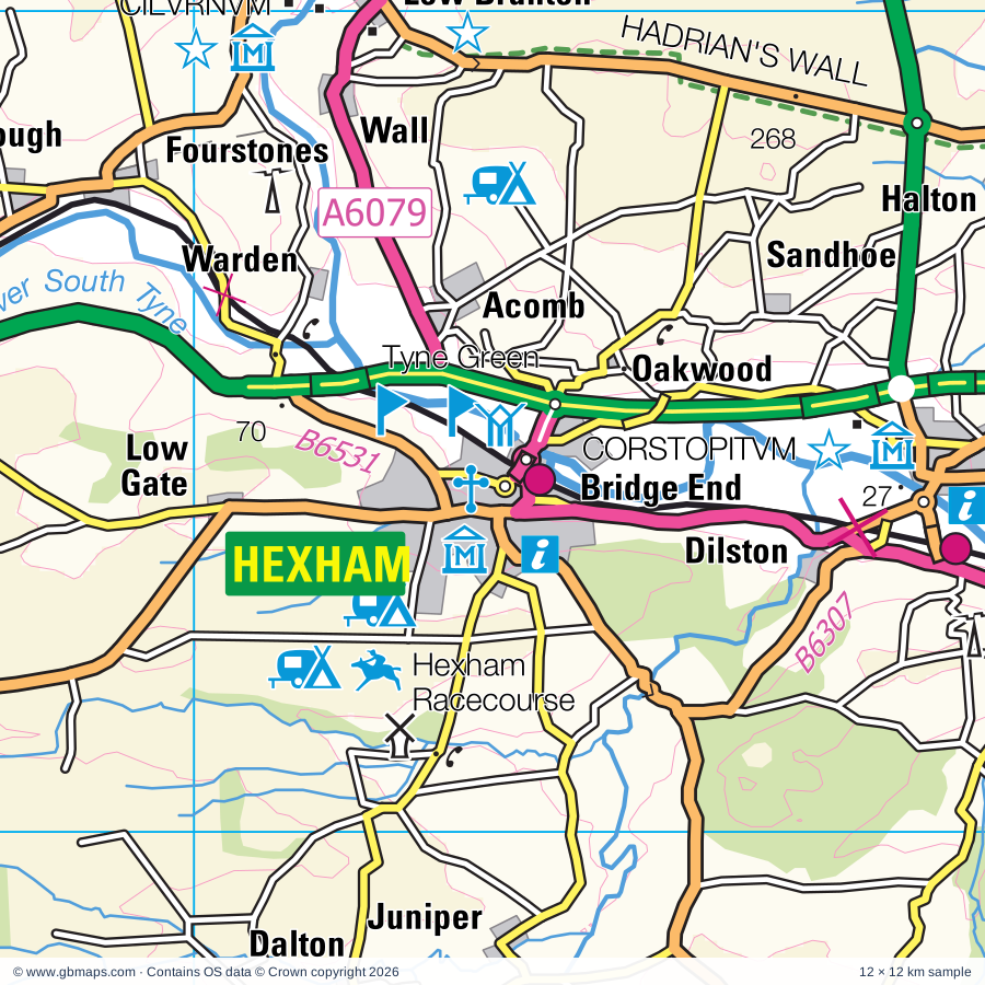
Explore the full 60 × 60 km Hexham regional road map at 1:250,000, covering Hexham, Corbridge, Haltwhistle, Prudhoe, Ryton. Compare the complete coverage below; a detailed PDF sample is available free.

HEXHAM & SURROUNDING AREAREGIONAL ROAD MAP
60 × 60 km · Full map previewDownload the free SVG ↓

INSIDE THE FULL 60 × 60 KM MAP

Explore the Hexham map area

1:250,000 cartography

Towns, villages & places

More mapped places (157)
  • Warden
  • Simonburn
  • Acomb
  • Gunnerton
  • Oakwood
  • Colwell
  • Sandhoe
  • Wark
  • Bingfield
  • Birtley
  • Dilston
  • Halton
  • Hallington
  • Thockrington
  • Aydon
  • Juniper
  • Dalton
  • Ryal
  • Stonehaugh
  • Whitley Chapel
  • Beltingham
  • Redesmouth
  • Matfen
  • Kirkheaton
  • Catton
  • Slaley
  • Whygate
  • Ridsdale
  • Henshaw
  • Riding Mill
  • Bellingham
  • Ingoe
  • Fenwick
  • Healey
  • Whitfield
  • Kirkharle
  • East Woodburn
  • Capheaton
  • West Woodburn
  • Wallridge
  • Bearsbridge
  • Melkridge
  • Kirkwhelpington
  • Ovington
  • Stamfordham
  • Knowesgate
  • Heugh
  • Black Heddon
  • Sinderhope
  • Lanehead
  • Whiteside
  • Mickley
  • Ovingham
  • Plenmeller
  • Horsley
  • Cambo
  • Ninebanks
  • Greenhaugh
  • Blanchland
  • Baybridge
  • Dalton
  • Whittonstall
  • Hunstanworth
  • Belsay
  • Middleton
  • Townfield
  • Milbourne
  • Harwood
  • Rothley
  • Medburn
  • Edmundbyers
  • Shotleyfield
  • Otterburn
  • Elsdon
  • Newlands
  • Carrshield
  • Crawcrook
  • Coalburns
  • Greenhead
  • Muggleswick
  • Hartburn
  • Chopwell
  • Falstone
  • Ebchester
  • Allenheads
  • Greenside
  • Ogle
  • Hamsterley
  • Lambley
  • Whalton
  • Longwitton
  • Meldon
  • Throckley
  • Allensford
  • Hooker Gate
  • Gilsland
  • Medomsley
  • Newburn
  • Barlow
  • Halton-Lea-Gate
  • Ayle
  • Knarsdale
  • Horsley
  • Rookhope
  • Highfield
  • Callerton
  • Castleside
  • Throphill
  • Nenthall
  • Midgeholme
  • Slaggyford
  • Netherwitton
  • Prestwick
  • Nenthead
  • Rochester
  • Waskerley
  • Lanehead
  • Rowley
  • Saltwick
  • Nunnykirk
  • Leadgate
  • Woolsington
  • Cowshill
  • Knitsley
  • Tindale
  • Dipton
  • Stanton
  • Burnopfield
  • Iveston
  • Hobson
  • Forestburn Gate
  • Crawleyside
  • Crookgate Bank
  • Mitford
  • Pigdon
  • Tantobie
  • Bayles
  • Wingates
  • Tranwell
  • Tanfield
  • Garrigill
  • Leadgate
  • Maiden Law
  • Satley
  • Longhorsley
  • Lanchester
  • Fenrother
  • Hebron
  • Cornsay
  • Burnhope
  • Kielder
  • Quebec
  • Esh
  • Deadwater
  • Waterhouses
  • Esh Winning
  • West Thirston

Roads across this sheet

A68, A69, A186, A191, A192, A197, A686, A689, A691, A692, A693, A694, A695, A696, A697, A6076, A6079, A6085, B6168, B6173, B6277, B6278, B6294, B6295

More road numbers

B6296, B6301, B6302, B6303, B6304, B6305, B6306, B6307, B6308, B6309, B6310, B6311, B6314, B6315, B6317, B6318, B6319, B6320, B6321, B6322, B6323, B6324, B6341, B6342, B6343, B6344, B6345, B6395, B6524, B6528, B6529, B6530, B6531, B6532, B6545, B6918

Rivers & waterways

Black Burn, Blacka Burn, Chirdon Burn, Croglin Water, Devil's Water, Fallowlees Burn, Kielder Burn, King Water, River Allen, River Blyth, River Browney, River Coquet

More waterways

River Derwent, River East Allen, River Font, River Irthing, River North Tyne, River Pont, River Rede, River South Tyne, River Tyne, River Wansbeck, River Wear, River West Allen, Warks Burn

Landmarks & landscape

Abbey, Allenheads Heritage Centre, Allensford Country Park, Aydon Castle, BREMENIVM, Bakethin Reservoir, Bardon Mill Pottery, Bastle, Bellingham Heritage Centre, Belsay Castle, Belsay Gardens, Belsay Hall, NORTHUMBERLAND NATIONAL PARK

More named features

Bide-a-Wee Cottage Garden, Birdoswald, Birdoswald Fort, Black Carts Turret 29a, Black Middens Bastle, Bolam Lake Country Park, Brigantium, Brinkburn Priory, Broadwell House, Brockbushes Farm, Brunton Turret 26b, CILVRNVM, CORSTOPITVM, Carrycoats Hall, Carvoran (World Heritage Site), Carvoran Roman Army Museum, Castle, Causey Arch, Causey Park, Cawfields Roman Wall, Thorny Doors, Cherryburn, Chesters Bridge Abutments, Chesters Bridge Abutments, Brunton Turret 26b, Chesters Roman Fort (World Heritage Site), Chesters Roman Fort Museum, Chimneys, Chipchase Castle, Churnsike Lodge, Corbridge Roman Site, Corbridge Roman Town (World Heritage Site), Dally Castle, Denton Hall Turret, Derwent Reservoir, Derwent Walk Country Park, Derwentcote Steel Furnace, Ebchester Roman Fort, Espley Hall, Featherstone Castle, Garden Station, George Stephenson's Cottage, Gibside, HABITANCVM, Hadrian's Wall (World Heritage Site), Hadrian's Wall (World Heritage), Housesteads Fort Visitor Centre, Hall, Hareshaw Linn, Harrows Scar Milecastle, Haughton Castle, Heddon-on-the-Wall, Herterton House Gardens, Hexham Abbey, Hexham Racecourse, Highgreen Manor, Hill Hall Farm, Hotel, Housesteads Fort Museum & Visitor Centre, Housesteads VERCOVICIVM ROMAN FORT, Kielder Castle, Kielder Castle Forest Park Centre, Kielder Orienteering Site, Kielder Forest Drive, Kielder Observatory, Kielder Ornamental Forest Drive, Kielder Water Birds of Prey Centre, Killhope Lead Mining Centre, Langley Castle, Leaplish Waterside Park, Meldon Park, Morpeth Chantry Bagpipe Museum, Morpeth Clock Tower, Newburn Hall Motor Museum, Newburn Tyne Riverside Country Park, Northumberland Cheese Farm, ONNVM, Otterburn Mill, Path Head Watermill, Percy's Cross, Plantrees Roman Wall, Poltross Burn Milecastle, Pow Hill Country Park, Prudhoe Castle, Sewingshields Wall, South Tynedale Railway, St Mary's Abbey, Sycamore Gap, Temple of Mithras, The Hall, The Highland Cattle Centre, The Hub, The Old Gaol, The Pennine Pottery, Thirlwall Castle, Thirwall Castle, Thornley Woodlands Centre, Tower Knowe Visitor Centre, Tureret 48a, Tureret 48b, Turret 48B, Birdoswald Fort (World Heritage Site), Tyne Green, Tyne Riverside Country Park, Tyneside Locomotive Museum, VALLUM, VINDOBALA, VINDOLANDA, VINDOMORA, Vindolanda (Chesterholm) Museum & Roman Fort (World Heritage Site), Visitor Centre, Wallington, Walltown Crags, Whitehouse Farm Centre, Willimoteswick, Willowford Wall, Willowford Bridgem, Harrows Scar Milecastle, Turret 48b, Turret 48a, Winshields Crag Wall, Winter's Gibbet, Wylam Railway Museum
Local authority & parish coverage

Wholly or partly within the full map rectangle. These boundaries are coverage information, not additional artwork layers.

  • County DurhamPartly within
  • CumberlandPartly within
  • Gateshead DistrictPartly within
  • Newcastle upon Tyne DistrictPartly within
  • NorthumberlandPartly within
  • Scottish BordersPartly within
  • Westmorland and FurnessPartly within
Wards & electoral divisions 59 areas
  • Alston and Fellside Ward (part)
  • Benwell, Scotswood & Denton Burn Ward (part)
  • Blaydon Ward (part)
  • Brampton Ward (part)
  • Chapel Ward
  • Chopwell & Rowlands Gill Ward
  • Corby and Hayton Ward (part)
  • Crawcrook & Greenside Ward
  • Denton & Westerhope Ward (part)
  • Hawick and Hermitage Ward (part)
  • Kingston Park & Dinnington Ward (part)
  • Lemington Ward
  • Longtown Ward (part)
  • Newbiggin Hall & Callerton Ward (part)
  • Ryton, Crookhill & Stella Ward
  • Throckley, Walbottle & Newburn Ward
  • West Fenham Ward (part)
  • Whickham North & Swalwell Ward (part)
  • Whickham South & Sunniside Ward (part)
  • Winlaton & High Spen Ward
  • Annfield Plain & Tanfield ED (part)
  • Bellingham ED (part)
  • Benfieldside ED
  • Choppington & Hepscott ED (part)
  • Consett North ED
  • Consett South ED
  • Corbridge ED
  • Craghead & South Moor ED (part)
  • Crook ED (part)
  • Deerness ED (part)
  • Delves Lane ED
  • Derwent & Pont Valley ED
  • Haltwhistle ED
  • Haydon & Hadrian ED
  • Hexham East ED
  • Hexham North ED
  • Hexham West ED
  • Humshaugh ED
  • Lanchester & Burnhope ED (part)
  • Langley & Esh ED (part)
  • Longhirst ED (part)
  • Longhorsley ED (part)
  • Morpeth Kirkhill ED (part)
  • Morpeth North ED (part)
  • Morpeth Stobhill ED (part)
  • Pegswood ED (part)
  • Ponteland East & Stannington ED (part)
  • Ponteland North ED
  • Ponteland South with Heddon ED
  • Ponteland West ED
  • Prudhoe North & Wylam ED
  • Prudhoe South ED
  • Prudhoe West & Mickley ED
  • Rothbury ED (part)
  • Shilbottle ED (part)
  • South Tynedale ED
  • Stanley ED (part)
  • Stocksfield & Bywell ED
  • Weardale ED (part)
Civil parishes & communities 117 areas
  • Acomb CP
  • Ainstable CP (part)
  • Allendale CP
  • Alston Moor CP (part)
  • Askerton CP (part)
  • Bardon Mill CP
  • Bavington CP
  • Bellingham CP
  • Belsay CP
  • Bewcastle CP (part)
  • Birtley CP
  • Blanchland CP
  • Brandon and Byshottles CP (part)
  • Brinkburn CP (part)
  • Broomhaugh and Riding CP
  • Burnhope CP (part)
  • Bywell CP
  • Capheaton CP
  • Castle Carrock CP (part)
  • Chollerton CP
  • Coanwood CP
  • Corbridge CP
  • Cornsay CP (part)
  • Corsenside CP
  • Dinnington CP (part)
  • Edmondbyers CP
  • Elsdon CP
  • Esh CP (part)
  • Falstone CP (part)
  • Farlam CP (part)
  • Featherstone CP
  • Felton CP (part)
  • Glassonby CP (part)
  • Greencroft CP
  • Greenhead CP
  • Greystead CP
  • Haltwhistle CP
  • Harbottle CP (part)
  • Hartburn CP
  • Hartleyburn CP
  • Haydon CP
  • Healey CP
  • Healeyfield CP
  • Hebron CP (part)
  • Heddon-on-the-Wall CP
  • Hedley CP
  • Hedleyhope CP (part)
  • Henshaw CP
  • Hepple CP (part)
  • Hepscott CP (part)
  • Hesleyhurst CP
  • Hexham CP
  • Hexhamshire CP
  • Hollinghill CP
  • Horsley CP
  • Humshaugh CP
  • Hunstanworth CP
  • Kielder CP (part)
  • Kingwater CP (part)
  • Kirkoswald CP (part)
  • Kirkwhelpington CP
  • Knaresdale with Kirkhaugh CP
  • LCPs of Stanhope, Wolsingham and Tow Law (part)
  • Lanchester CP (part)
  • Longframlington CP (part)
  • Longhorsley CP
  • Matfen CP
  • Meldon CP
  • Melkridge CP
  • Melmerby CP (part)
  • Midgeholme CP (part)
  • Mitford CP
  • Morpeth CP (part)
  • Muggleswick CP
  • Nether Denton CP (part)
  • Netherwitton CP
  • Newbrough CP
  • Nunnykirk CP
  • Otterburn CP (part)
  • Ousby CP (part)
  • Ovingham CP
  • Ovington CP
  • Pegswood CP (part)
  • Plenmeller with Whitfield CP
  • Ponteland CP
  • Prudhoe CP
  • Rochester CP (part)
  • Rothbury CP (part)
  • Rothley CP
  • Sandhoe CP
  • Satley CP (part)
  • Shotley Low Quarter CP
  • Simonburn CP
  • Slaley CP
  • Stamfordham CP
  • Stanhope CP (part)
  • Stanley CP (part)
  • Stannington CP (part)
  • Stocksfield CP
  • Tarset CP
  • Thirlwall CP
  • Thirston CP (part)
  • Tow Law CP (part)
  • Tritlington and West Chevington CP (part)
  • Upper Denton CP
  • Wall CP
  • Wallington Demesne CP
  • Warden CP
  • Wark CP
  • Waterhead CP (part)
  • West Allen CP
  • Whalton CP
  • Whittington CP
  • Whitton and Tosson CP (part)
  • Wolsingham CP (part)
  • Woolsington CP (part)
  • Wylam CP

Source: the GBMaps road atlas, OS Boundary-Line and postcode mapping datasets. Source editions are being checked for publication. Unmarked boundary names are wholly within the sheet; “part” means the map edge crosses the area.

Place lists are selected from the map source, not a complete gazetteer. Named features describe the cartography; visitor facilities and opening status are not verified. The free sample covers only 12 × 12 km of this larger sheet.

INSIDE YOUR DOWNLOAD

A proper road map, in useful formats

Road classifications, towns and villages, railways, rivers, landscape detail and tourist symbols, brought together in the GBMaps regional road atlas style.

PDF filePDFSVG fileSVGAdobe Illustrator AI fileAi

PDF for the finished map. SVG and layered Illustrator artwork for adapting colours, adding your own information and preparing designs.

THE FINISHED SHEET

Designed for print and presentation

Map coverage
60 × 60 km
Sample coverage
12 × 12 km
Print layout
A3 landscape · enlarged 1:250k cartography
Sheet furniture
Border, scale bar, key & north arrow

A few useful details

What changes when I select another square?

Select a surrounding square to bring it into the centre and reveal the maps around it. Each square is a different 60 × 60 km map. The preview, free sample and selected download change together. Neighbouring sheets overlap by 30 km so you can choose the coverage that suits you.

Is the free sample a vector map?

The on-page detail is an SVG. The free download is a separate 12 × 12 km PDF with a link to the full map. Please retain its copyright credits and product link when sharing it.

Can I buy a larger combined map?

These downloads are individual ready-made sheets. Contact GBMaps if you need a larger combined area.

FREE PDF SAMPLE

Your free map sample

Your free 12 × 12 km sample includes a link back to this map, so you can return for the full area whenever you need it.

Download free PDF sample ↓

Get your Hexham map

Map download bundle

£24.00including VATOne payment

Pay securely

One payment. Your map stays open.

Your map download

Your map files

Preparing your download…

Checking your private download link…

Your map downloads

Already bought a map?

Find the downloads from your purchases.

Enter the email address you used at checkout. We’ll email you a private link to your available map downloads.