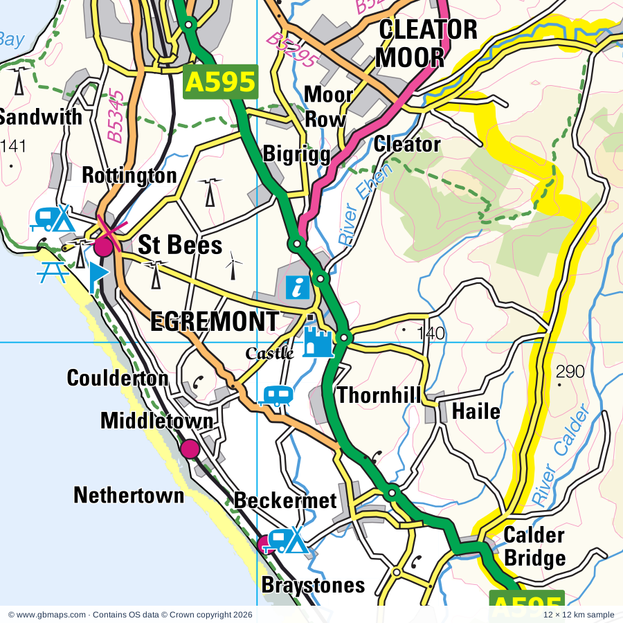
Explore the full 60 × 60 km Egremont regional road map at 1:250,000, covering Egremont, Whitehaven, Workington, Cockermouth, Maryport. Compare the complete coverage below; a detailed PDF sample is available free.
River Bleng, River Brathay, River Calder, River Caldew, River Cocker, River Derwent, River Duddon, River Ehen, River Ellen, River Esk, River Greta, River Irt
More waterways
River Keekle, River Liza, River Mite, Whillan Beck
Landmarks & landscape
Bowder Stone, Castle, Castlerigg Stone Circle, Cumbrian Heavy Horses, Drigg Dunes and Irt Estuary, Duddon Sands Nature Reserve, Dungeon Ghyll Force, Egremont Castle, Eskdale Mill, Friars Crag, Glannoventa Roman Fort, Hardknott Castle, NT Land, LAKE DISTRICT NATIONAL PARK
More named features
Helena Thompson Museum, Honister Slate Mine, Irton Cross, Isel Hall, James Bond Museum, Jennings Brewery, Castlegate House Gallery, Keswick Museum and Art Gallery, Cumberland Pencil Museum, King Kong Climbing Centre, Lake District Coast Aquarium, Lake District Wildlife Park, Lakeland Sheep & Wool Centre, Lodore Falls, Maryport Maritime Museum, Senhouse Museum, Millom Folk Museum, Mirehouse, Moss Force, Muncaster Castle, Muncaster Castle and Garden, Muncaster Watermill, Puzzling Place, ROMAN BATH HOUSE, ROMAN FORT, Ravenglass Railway Museum, Ravenglass Roman Bath House, Ravenglass and Eskdale Railway, Ruskin Museum, Scale Force, Spout Force, St Bees Head Nature Reserve, Stone Circle, Stubb Place, The Beacon, The Rum Story, Haig Colliery Mining Museum, The Printing House Museum, The Wave Centre, The World Owl Centre, Trinity Gardens and Labyrinth, Whinlatter Forest Park, Whinlatter Visitor Centre, GoApe Whinlatter, Wordsworth House, Workington Hall, Workington Hall (ruin)
Wholly or partly within the full map rectangle. These boundaries are coverage information, not additional artwork layers.
CumberlandPartly within
Westmorland and FurnessPartly within
Wards & electoral divisions 30 areas
Bothel and Wharrels Ward (part)
Bransty Ward
Cleator Moor East and Frizington Ward
Cleator Moor West Ward
Cockermouth North Ward
Cockermouth South Ward
Coniston and Hawkshead Ward (part)
Dalton North Ward (part)
Dearham and Broughton Ward (part)
Egremont North and St. Bees Ward
Egremont Ward
Gosforth Ward
Greystoke and Ullswater Ward (part)
Harrington Ward
High Furness Ward (part)
Hillcrest and Hensingham Ward
Howgate Ward
Kells and Sandwith Ward
Keswick Ward (part)
Maryport North Ward (part)
Maryport South Ward
Millom Ward (part)
Millom Without Ward (part)
Mirehouse Ward
Moss Bay and Moorclose Ward
Seaton Ward
St. John's and Great Clifton Ward
St. Michael's Ward
Thursby Ward (part)
Windermere and Ambleside Ward (part)
Civil parishes & communities 86 areas
Above Derwent CP
Angerton CP
Arlecdon and Frizington CP
Askam and Ireleth CP (part)
Bassenthwaite CP
Beckermet CP
Bewaldeth and Snittlegarth CP
Blawith and Subberthwaite CP
Blennerhasset and Torpenhow CP (part)
Blindbothel CP
Blindcrake CP
Boltons CP (part)
Bootle CP
Borrowdale CP
Bothel and Threapland CP (part)
Bridekirk CP
Brigham CP
Broughton CP
Broughton Moor CP
Broughton West CP
Buttermere CP
Caldbeck CP (part)
Camerton CP
Cleator Moor CP
Cockermouth CP
Colton CP (part)
Coniston CP (part)
Crosscanonby CP (part)
Dean CP
Dearham CP
Distington CP
Drigg and Carleton CP
Dunnerdale-with-Seathwaite CP
Egremont CP
Egton with Newland CP (part)
Embleton CP
Ennerdale and Kinniside CP
Eskdale CP
Gilcrux CP
Gosforth CP
Great Clifton CP
Greysouthen CP
Haile CP
Ireby and Uldale CP (part)
Irton with Santon CP
Keswick CP
Kirkby Ireleth CP (part)
Lakes CP (part)
Lamplugh CP
Little Clifton CP
Lorton CP
Lowca CP
Loweswater CP
Lowick CP (part)
Lowside Quarter CP
Mansriggs CP (part)
Maryport CP
Millom CP (part)
Millom Without CP
Moresby CP
Muncaster CP
Mungrisdale CP (part)
Osmotherley CP (part)
Oughterside and Allerby CP (part)
Papcastle CP
Parton CP
Pennington CP (part)
Plumbland CP (part)
Ponsonby CP
Seascale CP
Seaton CP
Setmurthy CP
St. Bees CP
St. John's Castlerigg and Wythburn CP (part)
Threlkeld CP (part)
Torver CP (part)
Ulpha CP
Underskiddaw CP (part)
Waberthwaite CP
Wasdale CP
Weddicar CP
Whicham CP (part)
Whitehaven CP
Winscales CP
Workington CP
Wythop CP
Source: the GBMaps road atlas, OS Boundary-Line and postcode mapping datasets. Source editions are being checked for publication. Unmarked boundary names are wholly within the sheet; “part” means the map edge crosses the area.
INSIDE YOUR DOWNLOAD
A proper road map, in useful formats
Road classifications, towns and villages, railways, rivers, landscape detail and tourist symbols, brought together in the GBMaps regional road atlas style.
PDF for the finished map. SVG and layered Illustrator artwork for adapting colours, adding your own information and preparing designs.
THE FINISHED SHEET
Designed for print and presentation
Map coverage
60 × 60 km
Sample coverage
12 × 12 km
Print layout
A3 landscape · enlarged 1:250k cartography
Sheet furniture
Border, scale bar, key & north arrow
A few useful details
What changes when I select another square?
Select a surrounding square to bring it into the centre and reveal the maps around it. Each square is a different 60 × 60 km map. The preview, free sample and selected download change together. Neighbouring sheets overlap by 30 km so you can choose the coverage that suits you.
Is the free sample a vector map?
The on-page detail is an SVG. The free download is a separate 12 × 12 km PDF with a link to the full map. Please retain its copyright credits and product link when sharing it.
Can I buy a larger combined map?
These downloads are individual ready-made sheets. Contact GBMaps if you need a larger combined area.