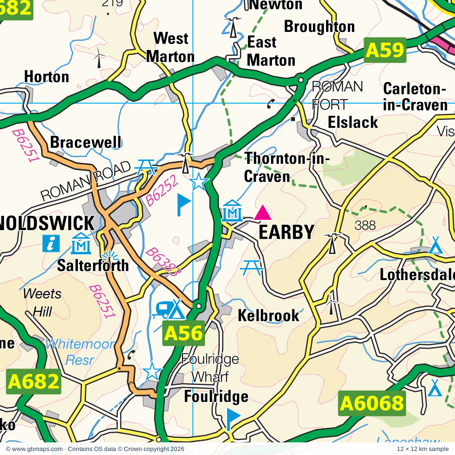
Earby regional road map. Full 60 × 60 km PDF, SVG and Illustrator files, with a free PDF sample.

GBMAPS.COM

Earby Regional Road Map

Call Us Now for Help01751 473136

GREAT BRITAIN ROAD ATLAS · 1:250,000 RY-13

Earby & surrounding area

Explore the full 60 × 60 km Earby regional road map at 1:250,000, covering Barnoldswick, Earby, Skipton, Colne, Barrowford. Compare the complete coverage below; a detailed PDF sample is available free.

EARBY & SURROUNDING AREAREGIONAL ROAD MAP
60 × 60 km · Full map previewDownload the free SVG ↓

INSIDE THE FULL 60 × 60 KM MAP

Explore the Earby map area

1:250,000 cartography

Towns, villages & places

More mapped places (213)

Roads across this sheet

M62, M65, M606, A56, A58, A59, A62, A65, A629, A638, A641, A643, A644, A646, A647, A649, A650, A651, A657, A658, A659, A660, A666, A671

More road numbers

A674, A675, A677, A678, A679, A680, A681, A682, A683, A687, A6025, A6026, A6033, A6034, A6035, A6036, A6037, A6038, A6061, A6062, A6066, A6068, A6069, A6077, A6078, A6107, A6114, A6119, A6131, A6139, A6142, A6176, A6177, A6181, A6185, B5256, B5269, B6112, B6113, B6114, B6118, B6119, B6120, B6121, B6130, B6138, B6141, B6142, B6143, B6144, B6145, B6146, B6147, B6149, B6151, B6153, B6160, B6165, B6172, B6214, B6230, B6231, B6232, B6234, B6235, B6236, B6237, B6238, B6239, B6240, B6243, B6244, B6245, B6246, B6247, B6248, B6249, B6250, B6251, B6252, B6253, B6254, B6255, B6265, B6269, B6379, B6380, B6381, B6382, B6383, B6429, B6434, B6446, B6447, B6451, B6478, B6479, B6480, B6527, B6535

Rivers & waterways

Calder & Hebble Navigation, Cam Beck, Eller Beck, Hebden Water, How Stean Beck, Huddersfield Broad Canal, Kex Beck, Leck Beck, Leeds & Liverpool Canal, River Aire, River Calder, River Darwen

More waterways

River Dibb, River Greta, River Hindburn, River Hodder, River Irwell, River Lune, River Nidd, River Ribble, River Skirfare, River Washburn, River Wenning, River Wharfe, River Worth, River Wyre, Rochdale Canal, Sabden Brook, Tosside Beck

Landmarks & landscape

Abbey, Aire Head, Aisled Barn Visitor Centre, Bacup Museum, Baildon Craft Centre, Bancroft Mill, Bankfield Museum, Barden Tower, Barden Tower (remains of), Bath House, Bentham Pottery, Bingley Five Rise Locks, YORKSHIRE DALES NATIONAL PARK

More named features

Blackburn Cathedral, Bolling Hall Museum, Bolton Priory, Bracken Hall Countryside Centre, Shipley Glen Tramway, Bradford Cathedral, Bradford Industrial Museum & Horses at Work, Bronte Parsonage Museum, Bronte Weaving Shed, Browsholme Hall, Cartwright Hall Art Gallery and Museum, Castle, Centre Vale Park, Chipping Wild Boar Park, Cliffe Castle, Keighley Bus Museum, Clitheroe Castle, Clitheroe Castle Museum, Clough Head Visitor Centre, Copper Dragon Brewery Visitor Centre, Craven Museum, Crimsworth Dean, Cromwells Bridge, Cycle Trails, Dean Clough Gallery, Square Chapel Centre for the Arts, Piece Hall Arts Gallery, Earby Museum Of Mines, East Lancashire Railway, East Riddlesden Hall, Embsay Steam Railway, Eureka The Museum for Children, Foulridge Wharf, Garden, Gawthorpe Hall, Goodshaw Chapel, Gordale Scar, Great Stone Of Fourstones, Grimwith Reservoir Beauty Spot, Hall, Hardcastle Crags, Haworth Art Galleries, Helmshore Textile Museum, Heptonstall, Hesketh Farm Park, Higher & Lower Holme House Woods, Historic Milestones, Hoghton Tower, Horton Bank Country Park, How Stean Gorge, Ingleborough National Nature Reserve, Ingleton Waterfalls, Janet's Foss, Keighley & Worth Valley Railway, Kilnsey Crag, Kilnsey Park, Lewes Garden Nature Reserve, Lewis Textile Museum & Blackburn Museum & Art Gallery, Linton Falls, Lower Grass Wood Nature Reserve, Lumb Hole Waterfall, Malham Cove, Manor Heath Park Garden, Manor House Museum (Ilkley Manor House), Mrs Dowsons Ice Cream, Museum of North Craven Life, Myttons Farm Crafts, National Media Museum, Nidderdale Museum, Ogden Water Country Park, Ogden Water Visitor Centre, Oswaldtwistle Mills, Parcevall Hall Garden, Penistone Hill Country Park, Planet Earth Centre, Platform 4 Model Transport Museum, Platform Gallery, Pleasington Nature Reserve, Queen Street Mill, ROMAN FORT, Railway Carriage Museum, Ribblehead Viaduct, Ribchester Roman Museum, Roddlesworth Visitor Centre, Rossendale Museum, Saltaire (World Heritage Site), Samlesbury Hall, Sawley Abbey, Scaleber Force, Scoska Wood, Shibden Hall, Shibden Park, Skipton Castle, Smith Art Gallery, Snow Falls, Beezley Falls, Stainforth Force, Catrigg Force, Steam Train Museum, Stonyhurst College, Stonyhurst College Garden, Stoodley Pike Monument, Sunnyhurst Wood Visitor Centre, Swilla Glen, Tarn Moss Nature Reserve, The Darley Mill Centre, The Singing Ringing Tree, The Weavers Triangle Visitor Centre, Thornton Force, Pecca Falls, Thornton Hall Farm, Tower, Towneley Hall, Trollers Gill, Trow Gill, Upper Wharfedale Folk Museum, Visitor & Canal Centre, Visitor Centre, Walley Abbey Visitor Centre, Watershed Mill Visitor Centre, Weavers Cottage, Lamberts Mill Footwear Museum, Wellybobs, Whalley Abbey Gatehouse, Wildlife Centre, Witton Park Country Park, Wycoller Country Park, Yorkshire Craft Centre, Yorkshire Dales Falconry & Conservation Centre
Local authority & parish coverage

Wholly or partly within the full map rectangle. These boundaries are coverage information, not additional artwork layers.

  • Blackburn with DarwenPartly within
  • Bradford DistrictPartly within
  • Burnley DistrictWholly within
  • Calderdale DistrictPartly within
  • Chorley DistrictPartly within
  • Hyndburn DistrictWholly within
  • Kirklees DistrictPartly within
  • Lancaster DistrictPartly within
  • Leeds DistrictPartly within
  • North YorkshirePartly within
  • Pendle DistrictWholly within
  • Preston DistrictPartly within
  • Ribble Valley DistrictPartly within
  • Rochdale DistrictPartly within
  • Rossendale DistrictPartly within
  • South Ribble DistrictPartly within
  • Westmorland and FurnessPartly within
Wards & electoral divisions 182 areas
  • Airedale Ward
  • Alston & Hothersall Ward (part)
  • Altham Ward
  • Ashbrow Ward (part)
  • Audley & Queen's Park Ward
  • Bacup Ward
  • Baildon Ward
  • Bank Hall Ward
  • Barnfield Ward
  • Barnoldswick Ward
  • Barrowford & Pendleside Ward
  • Bastwell & Daisyfield Ward
  • Baxenden Ward
  • Billinge & Beardwood Ward
  • Billington & Langho Ward
  • Bingley East Ward
  • Bingley West Ward
  • Birstall & Birkenshaw Ward (part)
  • Blackburn Central Ward
  • Blackburn South & Lower Darwen Ward
  • Blackburn South East Ward
  • Bolton & Undercliffe Ward
  • Boulsworth & Foulridge Ward
  • Bowland Ward
  • Bowling & Barkerend Ward
  • Bradford Moor Ward
  • Bradley Ward
  • Briercliffe Ward
  • Brierfield East & Clover Hill Ward
  • Brierfield West & Reedley Ward
  • Brighouse Ward
  • Britannia & Lee Mill Ward (part)
  • Brockhall & Dinckley Ward
  • Brunshaw Ward
  • Calverley & Farsley Ward (part)
  • Central Ward
  • Chatburn Ward
  • Chipping Ward (part)
  • Chorley North East Ward (part)
  • Church Ward
  • City Ward
  • Clayton & Fairweather Green Ward
  • Clayton East, Brindle & Hoghton Ward (part)
  • Clayton-le-Dale & Salesbury Ward
  • Clayton-le-Moors Ward
  • Cleckheaton Ward (part)
  • Cliviger with Worsthorne Ward
  • Coal Clough with Deerplay Ward
  • Coupe Green & Gregson Lane Ward (part)
  • Dalton Ward (part)
  • Daneshouse with Stoneyholme Ward
  • Darwen East Ward
  • Darwen South Ward (part)
  • Darwen West Ward (part)
  • Derby & Thornley Ward (part)
  • Dilworth Ward
  • Earby & Coates Ward
  • East Whalley, Read & Simonstone Ward
  • Eccleshill Ward
  • Edisford & Low Moor Ward
  • Elland Ward (part)
  • Ellel Ward (part)
  • Ewood Ward
  • Fence & Higham Ward
  • Gannow Ward
  • Gawthorpe Ward
  • Gisburn & Rimington Ward
  • Goodshaw & Cribden Ward
  • Great Horton Ward
  • Greenfield & Eden Ward (part)
  • Greetland Ward (part)
  • Guiseley & Rawdon Ward (part)
  • Halifax Town Ward
  • Halton-with-Aughton & Kellet Ward (part)
  • Hapton with Park Ward
  • Hareholme & Waterfoot Ward (part)
  • Haslingden Ward
  • Heaton & Frizinghall Ward
  • Hebden Bridge & Todmorden East Ward (part)
  • Heckmondwike Ward (part)
  • Helmshore Ward (part)
  • Hipperholme & Lightcliffe Ward
  • Holme Wood & Bierley Ward (part)
  • Horsforth Ward (part)
  • Huncoat Ward
  • Hurst Green & Whitewell Ward
  • Idle & Thackley Ward (part)
  • Ilkley & Addingham Ward
  • Illingworth & Mixenden Ward
  • Immanuel Ward
  • Keighley Central Ward
  • Keighley East Ward
  • Keighley West Ward
  • Lanehead Ward
  • Little Harwood & Whitebirk Ward
  • Little Horton Ward
  • Littleborough Lakeside Ward (part)
  • Littlemoor Ward
  • Liversedge & Gomersal Ward (part)
  • Livesey with Pleasington Ward
  • Longholme Ward
  • Lower Lune Valley Ward (part)
  • Luddendenfoot Ward (part)
  • Manningham Ward
  • Marsden & Southfield Ward
  • Mellor Ward
  • Mill Hill & Moorgate Ward
  • Milnshaw Ward
  • Mirfield Ward (part)
  • Netherton Ward
  • Northowram & Shelf Ward
  • Otley & Yeadon Ward (part)
  • Ovenden Ward
  • Overton Ward
  • Park Ward
  • Peel Ward
  • Preston Rural East Ward (part)
  • Primrose Ward
  • Pudsey Ward (part)
  • Queensbury Ward
  • Queensgate Ward
  • Rastrick Ward
  • Ribchester Ward
  • Rishton Ward
  • Roe Lee Ward
  • Rosegrove with Lowerhouse Ward
  • Rosehill with Burnley Wood Ward
  • Royds Ward
  • Ryburn Ward (part)
  • Sabden Ward
  • Salterhebble, Southowram & Skircoat Green Ward
  • Salthill Ward
  • Samlesbury & Walton Ward (part)
  • Sedbergh and Kirkby Lonsdale Ward (part)
  • Shear Brow & Corporation Park Ward
  • Shipley Ward
  • Sowerby Bridge Ward
  • Spring Hill Ward
  • St. Andrew's Ward
  • St. Mary's Ward
  • St. Oswald's Ward
  • Thornton & Allerton Ward
  • Todmorden West Ward (part)
  • Toller Ward
  • Trinity Ward
  • Upper Lune Valley Ward (part)
  • Vivary Bridge Ward
  • Waddington, Bashall Eaves & Mitton Ward
  • Wainhouse Ward
  • Wardle, Shore & West Littleborough Ward (part)
  • Warley Ward
  • Waterside & Horsfield Ward
  • Wensley Fold Ward
  • West Bradford & Grindleton Ward
  • West Pennine Ward (part)
  • Whalley & Painter Wood Ward
  • Whalley Nethertown Ward
  • Wharfedale Ward
  • Whitefield & Walverden Ward
  • Whitewell & Stacksteads Ward (part)
  • Whittlefield with Ightenhill Ward
  • Whitworth Ward (part)
  • Wibsey & Odsal Ward
  • Wilpshire & Ramsgreave Ward
  • Windhill & Wrose Ward
  • Wiswell & Barrow Ward
  • Worth Valley Ward
  • Wyke Ward
  • Aire Valley ED
  • Bentham & Ingleton ED (part)
  • Glusburn, Cross Hills & Sutton-in-Craven ED
  • Leyburn & Middleham ED (part)
  • Masham & Fountains ED (part)
  • Mid Craven ED
  • Pateley Bridge & Nidderdale ED (part)
  • Settle & Penyghent ED (part)
  • Skipton East & South ED
  • Skipton North & Embsay-with-Eastby ED
  • Skipton West & West Craven ED
  • Upper Dales ED (part)
  • Washburn & Birstwith ED (part)
  • Wharfedale ED (part)
Civil parishes & communities 249 areas
  • Addingham CP
  • Aighton, Bailey and Chaigley CP
  • Airton CP
  • Altham CP
  • Appletreewick CP
  • Arkholme-with-Cawood CP (part)
  • Arncliffe CP
  • Askwith CP
  • Austwick CP
  • Baildon CP
  • Balderstone CP
  • Bank Newton CP
  • Barden CP
  • Barley-with-Wheatley Booth CP
  • Barnoldswick CP
  • Barrow CP
  • Barrowford CP
  • Bashall Eaves CP
  • Beamsley CP
  • Bentham CP
  • Bewerley CP
  • Billington and Langho CP
  • Bingley CP
  • Bishopdale CP (part)
  • Blacko CP
  • Blackshaw CP
  • Blubberhouses CP
  • Bolton Abbey CP
  • Bolton-by-Bowland CP
  • Bowland Forest High CP (part)
  • Bowland Forest Low CP
  • Bowland-with-Leagram CP
  • Bradleys Both CP
  • Briercliffe CP
  • Brierfield CP
  • Brindle CP (part)
  • Broughton CP
  • Buckden CP (part)
  • Burley CP
  • Burnsall CP
  • Burrow-with-Burrow CP
  • Burton in Lonsdale CP
  • Burton-cum-Walden CP (part)
  • Calton CP
  • Cantsfield CP
  • Carleton CP
  • Carlton Highdale CP (part)
  • Casterton CP (part)
  • Caton-with-Littledale CP (part)
  • Chatburn CP
  • Chipping CP (part)
  • Clapham cum Newby CP
  • Clayton CP
  • Clayton-le-Dale CP
  • Clitheroe CP
  • Cliviger CP
  • Colne CP
  • Colsterdale CP (part)
  • Coniston Cold CP
  • Conistone with Kilnsey CP
  • Cononley CP
  • Cowling CP
  • Cracoe CP
  • Cross Roads CP
  • Cullingworth CP
  • Dacre CP (part)
  • Darley and Menwith CP (part)
  • Darwen CP (part)
  • Denholme CP
  • Denton CP
  • Dinckley CP
  • Downham CP
  • Draughton CP
  • Dunnockshaw CP
  • Dutton CP
  • Earby CP
  • Easington CP
  • Eavestone CP (part)
  • Eccleshill CP
  • Elslack CP
  • Embsay with Eastby CP
  • Erringden CP
  • Eshton CP
  • Farnhill CP
  • Farnley CP (part)
  • Fearby CP (part)
  • Fewston CP (part)
  • Flasby with Winterburn CP
  • Foulridge CP
  • Fountains Earth CP
  • Gargrave CP
  • Giggleswick CP
  • Gisburn CP
  • Gisburn Forest CP
  • Glusburn and Cross Hills CP
  • Goldshaw Booth CP
  • Grassington CP
  • Great Mitton CP
  • Great Timble CP
  • Grewelthorpe CP (part)
  • Grimsargh CP (part)
  • Grindleton CP
  • Habergham Eaves CP
  • Halton East CP
  • Halton Gill CP
  • Halton West CP
  • Hanlith CP
  • Hapton CP
  • Harden CP
  • Hartlington CP
  • Hartwith cum Winsley CP (part)
  • Hawkswick CP
  • Haworth and Stanbury CP
  • Hazlewood with Storiths CP
  • Healey CP (part)
  • Heapey CP (part)
  • Hebden CP
  • Hebden Royd CP (part)
  • Hellifield CP
  • Heptonstall CP
  • Hetton-cum-Bordley CP
  • High and Low Bishopside CP (part)
  • Higham-with-West Close Booth CP
  • Hoghton CP (part)
  • Hornby-with-Farleton CP (part)
  • Horton CP
  • Horton in Ribblesdale CP (part)
  • Hothersall CP
  • Ightenhill CP
  • Ilkley CP
  • Ilton-cum-Pott CP (part)
  • Ingleton CP (part)
  • Ireby CP
  • Keighley CP
  • Kelbrook and Sough CP
  • Kettlewell with Starbotton CP
  • Kildwick CP
  • Kirkburton CP (part)
  • Kirkby Lonsdale CP (part)
  • Kirkby Malham CP
  • Kirkby Malzeard CP (part)
  • Laneshaw Bridge CP
  • Langcliffe CP
  • Laverton CP (part)
  • Lawkland CP
  • Leck CP (part)
  • Linton CP
  • Little Mitton CP
  • Little Timble CP
  • Litton CP
  • Livesey CP
  • Long Preston CP
  • Longridge CP (part)
  • Lothersdale CP
  • Malham CP
  • Malham Moor CP
  • Martons Both CP
  • Mearley CP
  • Melling-with-Wrayton CP (part)
  • Mellor CP
  • Menston CP
  • Middleton CP
  • Middop CP
  • Mirfield CP (part)
  • Nelson CP
  • Nesfield with Langbar CP
  • Newall with Clifton CP (part)
  • Newsholme CP
  • Newton CP
  • North Turton CP (part)
  • Norwood CP (part)
  • Old Laund Booth CP
  • Osbaldeston CP
  • Otley CP (part)
  • Otterburn CP
  • Over Wyresdale CP (part)
  • Oxenhope CP
  • Padiham CP
  • Paythorne CP
  • Pendleton CP
  • Pleasington CP
  • Ramsgreave CP
  • Rathmell CP
  • Rawdon CP (part)
  • Read CP
  • Reedley Hallows CP
  • Ribchester CP
  • Rimington CP
  • Ripponden CP (part)
  • Roeburndale CP (part)
  • Roughlee Booth CP
  • Rylstone CP
  • Sabden CP
  • Salesbury CP
  • Salterforth CP
  • Samlesbury CP (part)
  • Sandy Lane CP
  • Sawley CP
  • Scosthrop CP
  • Settle CP
  • Shipley CP
  • Silsden CP
  • Simonstone CP
  • Skelding CP (part)
  • Skipton CP
  • Slaidburn CP
  • Stainforth CP
  • Stainland and District CP (part)
  • Steeton with Eastburn CP
  • Stirton with Thorlby CP
  • Stonebeck Down CP
  • Stonebeck Up CP
  • Sutton CP
  • Swinton with Warthermarske CP (part)
  • Tatham CP (part)
  • Thornley-with-Wheatley CP (part)
  • Thornthwaite with Padside CP
  • Thornton in Craven CP
  • Thornton in Lonsdale CP (part)
  • Thorpe CP
  • Threshfield CP
  • Thruscross CP
  • Tockholes CP (part)
  • Todmorden CP (part)
  • Trawden Forest CP
  • Trident CP
  • Tunstall CP (part)
  • Twiston CP
  • Waddington CP
  • Wadsworth CP
  • Wennington CP
  • West Bradford CP
  • West Scrafton CP (part)
  • Weston CP
  • Whalley CP
  • Wheelton CP (part)
  • Whittingham CP (part)
  • Whittington CP (part)
  • Whitworth CP (part)
  • Wigglesworth CP
  • Wilpshire CP
  • Wilsden CP
  • Wiswell CP
  • Withnell CP (part)
  • Worsthorne-with-Hurstwood CP
  • Worston CP
  • Wray-with-Botton CP (part)
  • Wrose CP
  • Yate and Pickup Bank CP

Source: the GBMaps road atlas, OS Boundary-Line and postcode mapping datasets. Source editions are being checked for publication. Unmarked boundary names are wholly within the sheet; “part” means the map edge crosses the area.

Place lists are selected from the map source, not a complete gazetteer. Named features describe the cartography; visitor facilities and opening status are not verified. The free sample covers only 12 × 12 km of this larger sheet.

INSIDE YOUR DOWNLOAD

A proper road map, in useful formats

Road classifications, towns and villages, railways, rivers, landscape detail and tourist symbols, brought together in the GBMaps regional road atlas style.

PDF filePDFSVG fileSVGAdobe Illustrator AI fileAi

PDF for the finished map. SVG and layered Illustrator artwork for adapting colours, adding your own information and preparing designs.

THE FINISHED SHEET

Designed for print and presentation

Map coverage
60 × 60 km
Sample coverage
12 × 12 km
Print layout
A3 landscape · enlarged 1:250k cartography
Sheet furniture
Border, scale bar, key & north arrow

A few useful details

What changes when I select another square?

Select a surrounding square to bring it into the centre and reveal the maps around it. Each square is a different 60 × 60 km map. The preview, free sample and selected download change together. Neighbouring sheets overlap by 30 km so you can choose the coverage that suits you.

Is the free sample a vector map?

The on-page detail is an SVG. The free download is a separate 12 × 12 km PDF with a link to the full map. Please retain its copyright credits and product link when sharing it.

Can I buy a larger combined map?

These downloads are individual ready-made sheets. Contact GBMaps if you need a larger combined area.

FREE PDF SAMPLE

Your free map sample

Your free 12 × 12 km sample includes a link back to this map, so you can return for the full area whenever you need it.

Download free PDF sample ↓

Get your Earby map

Map download bundle

£24.00including VATOne payment

Pay securely

One payment. Your map stays open.

Your map download

Your map files

Preparing your download…

Checking your private download link…

Your map downloads

Already bought a map?

Find the downloads from your purchases.

Enter the email address you used at checkout. We’ll email you a private link to your available map downloads.