Dundee regional road map. Full 60 × 60 km PDF, SVG and Illustrator files, with a free PDF sample.

GBMAPS.COM

Dundee Regional Road Map

Call Us Now for Help01751 473136

GREAT BRITAIN ROAD ATLAS · 1:250,000 GB-360-0750

Dundee & surrounding area

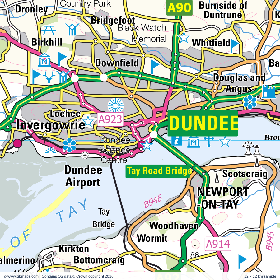
Explore the full 60 × 60 km Dundee regional road map at 1:250,000, covering Dundee, Arbroath, Brechin, Montrose, Forfar. Compare the complete coverage below; a detailed PDF sample is available free.

DUNDEE & SURROUNDING AREAREGIONAL ROAD MAP
60 × 60 km · Full map previewDownload the free SVG ↓

INSIDE THE FULL 60 × 60 KM MAP

Explore the Dundee map area

1:250,000 cartography

Towns, villages & places

More mapped places (120)
  • Cauldcots
  • Inverkeilor
  • Redford
  • Turin
  • Letham
  • Marywell
  • St Vigeans
  • Carmyllie
  • Dunnichen
  • Greystone
  • Netherton
  • Lunan
  • Ethie
  • Arbirlot
  • Auchmithie
  • Aberlemno
  • Rescobie
  • Tulloes
  • Barnhead
  • Craichie
  • Maryton
  • Elliot
  • Dun
  • Kirkbuddo
  • Careston
  • Kingsmuir
  • Lownie Moor
  • Lunanhead
  • Trinity
  • Finavon
  • Caldhame
  • Whigstreet
  • Muirdrum
  • Usan
  • East Haven
  • Oathlaw
  • Newtonmill
  • Craigton
  • Tannadice
  • Monikie
  • Hillside
  • Inchbare
  • Tigerton
  • Inverarity
  • Balhall
  • Fern
  • Logie
  • Barry
  • Craigo
  • Gateside
  • Noranside
  • Newbigging
  • Padanaram
  • Marykirk
  • Kirkton
  • Douglastown
  • Wellbank
  • Edzell
  • Balfield
  • Drumsturdy
  • Ballindarg
  • Luthermuir
  • Bridgend
  • Edzell Woods
  • Memus
  • Glenogil
  • Kellas
  • Gannochy
  • Sauchieburn
  • St Cyrus
  • Maryton
  • Glamis
  • Charleston
  • Inveraldie
  • Tealing
  • Cortachy
  • Kirkton of Tealing
  • Westmuir
  • Dykehead
  • Fettercairn
  • Pearsie
  • Eassie
  • Johnshaven
  • Bridgefoot
  • Craigton
  • Balkeerie
  • Benholm
  • Dronley
  • Kirkinch
  • Birkhill
  • Auchterhouse
  • Muirhead
  • Fordoun
  • Pickletillum
  • Auchenblae
  • St Michaels
  • Liff
  • Tarfside
  • Leuchars
  • Invergowrie
  • Arbuthnott
  • Fowlis
  • Allardice
  • Lucklawhill
  • Kingoodie
  • Balmullo
  • Gauldry
  • Kirkton
  • Mondynes
  • Bottomcraig
  • Longforgan
  • Balmerino
  • Kilmany
  • Logie
  • Clova
  • Kinneff
  • Rathillet
  • Catterline
  • Creich
  • Brunton

Roads across this sheet

A85, A92, A94, A914, A919, A923, A926, A928, A929, A930, A932, A933, A934, A935, A937, A972, A991, B945, B946, B951, B954, B955, B956, B957

More road numbers

B959, B960, B961, B962, B964, B965, B966, B967, B974, B978, B995, B9095, B9100, B9112, B9113, B9120, B9127, B9128, B9133, B9134

Rivers & waterways

Allt Darrarie, Bervie Water, Burn of Callater, Burn of Turret, Cruick Water, Dean Water, Dighty Water, Elliot Water, Lunan Water, Luther Water, Monikie Burn, Noran Water

More waterways

Prosen Water, River Isla, River North Esk, River South Esk, Water of Charr, Water of Mark, Water of Saughs, Water of Tarf, Water of Unich, West Water

Landmarks & landscape

Aberlemno Sculptured Stones, Affleck Castle, Angus Folk Museum, Arbroath Abbey, Arbroath Gallery, Visitor Centre, Arbroath Museum, Hospitalfield House, Ardestie Earth House, Ardestie Souterrain, Balbegno Castle, Balgavies Loch Wildlife Reserve, Balmerino Abbey, Bamse, Heroic Norwegian WW2 Sea Dog, CAIRNGORMS NATIONAL PARK

More named features

Barnhill Rock Garden, Barry Mill, Bechin Round Tower, Bechin Round Tower, Brechin Cathedral, Black Watch Memorial, Brechin Cathedral, Brechin Museum, Brechin Town House Museum, Broughty Castle, Broughty Castle Museum, Brown Caterthun, Cairn, Caledonian Railway, Camera Obscura, Camperdown House, Camperdown Park, Camperdown Wildlife Centre, Careston Castle, Carlungie Earth House, Carlungie Souterrain, Castle Huntly, Clatto Country Park, Claypotts Castle, Cortachy Castle, Crombie Country Park, Cross, Cross Slab Aberlemno, Cruivie Castle, Discovery Point, Bonar Hall Arts Centre, Dundee Science Centre, Dunninald House, Duntrune Demonstration Garden, Eassie Sculptured Stone, Edzell Castle and Garden, Ethie Castle, Ethiebeaton Park Visitor Centre, Fasque, Fettercairn Arch, Fettercairn Distillery, Finavon Castle, Finavon Dovecot, Forest Walks, Forfar Loch Country Park, Forfar Loch Visitor Centre, Fowlsheugh Nature Reserve, Glamis Castle, Glencadam Distillery, Glenesk Folk Museum, Go-karting, HM Frigate Unicorn, Verdant Works, Dundee Contempory Arts, Sensation Dundee, House of Dun, Hunthill Lodge, J M Barrie's Birthplace Museum, Kirriemuir Gateway to the Glens Museum, Kelly Castle, Kinnaird Castle, Lauriston Castle, Loch of Kinnordy Nature Reserve, Maggie Law Maritime Museum, Maison Dieu Chapel, Mc Manus Galleries, Dundee Museum of Transport, Meffen Museum and Art Gallery, Melgund Castle, Mill of Benholm, Millden Lodge, Mills Observatory, Monikie Country Park, Montrose Basin Visitor Centre, Montrose Basin Wildlife Centre, Montrose Museum and Art Gallery, Montrose Aerodrome Museum, Monument, Mountains Animal Sanctuary, Murton Farm, Nature Reserve, Oathlaw Pottery, Pictavia, Pitmuies Garden, Restenneth Priory, Ruthven House, St Andrews Cathedral, St Pauls Cathedral, St Cyrus NNR Visitor Centre, St Vigeans Museum, Tealing Earth House (Souterrain), Tentsmuir Point Nature Reserve, The Grassic Gibbon Visitor Centre, Thornton Castle, University (of Dundee) Botanic Garden, White Caterthun
Local authority & parish coverage

Wholly or partly within the full map rectangle. These boundaries are coverage information, not additional artwork layers.

  • AberdeenshirePartly within
  • AngusPartly within
  • Dundee CityWholly within
  • FifePartly within
  • Perth and KinrossPartly within
Wards & electoral divisions 25 areas
  • Aboyne, Upper Deeside and Donside Ward (part)
  • Arbroath East and Lunan Ward
  • Arbroath West, Letham and Friockheim Ward
  • Banchory and Mid Deeside Ward (part)
  • Brechin and Edzell Ward (part)
  • Carnoustie and District Ward
  • Carse of Gowrie Ward (part)
  • Coldside Ward
  • East End Ward
  • Forfar and District Ward
  • Howe of Fife and Tay Coast Ward (part)
  • Kirriemuir and Dean Ward (part)
  • Lochee Ward
  • Maryfield Ward
  • Mearns Ward (part)
  • Monifieth and Sidlaw Ward (part)
  • Montrose and District Ward
  • North East Ward
  • St. Andrews Ward (part)
  • Stonehaven and Lower Deeside Ward (part)
  • Strathmartine Ward
  • Strathmore Ward (part)
  • Tay Bridgehead Ward (part)
  • The Ferry Ward
  • West End Ward
Civil parishes & communities 0 areas

    Source: the GBMaps road atlas, OS Boundary-Line and postcode mapping datasets. Source editions are being checked for publication. Unmarked boundary names are wholly within the sheet; “part” means the map edge crosses the area.

    Place lists are selected from the map source, not a complete gazetteer. Named features describe the cartography; visitor facilities and opening status are not verified. The free sample covers only 12 × 12 km of this larger sheet.

    INSIDE YOUR DOWNLOAD

    A proper road map, in useful formats

    Road classifications, towns and villages, railways, rivers, landscape detail and tourist symbols, brought together in the GBMaps regional road atlas style.

    PDF filePDFSVG fileSVGAdobe Illustrator AI fileAi

    PDF for the finished map. SVG and layered Illustrator artwork for adapting colours, adding your own information and preparing designs.

    THE FINISHED SHEET

    Designed for print and presentation

    Map coverage
    60 × 60 km
    Sample coverage
    12 × 12 km
    Print layout
    A3 landscape · enlarged 1:250k cartography
    Sheet furniture
    Border, scale bar, key & north arrow

    A few useful details

    What changes when I select another square?

    Select a surrounding square to bring it into the centre and reveal the maps around it. Each square is a different 60 × 60 km map. The preview, free sample and selected download change together. Neighbouring sheets overlap by 30 km so you can choose the coverage that suits you.

    Is the free sample a vector map?

    The on-page detail is an SVG. The free download is a separate 12 × 12 km PDF with a link to the full map. Please retain its copyright credits and product link when sharing it.

    Can I buy a larger combined map?

    These downloads are individual ready-made sheets. Contact GBMaps if you need a larger combined area.

    FREE PDF SAMPLE

    Your free map sample

    Your free 12 × 12 km sample includes a link back to this map, so you can return for the full area whenever you need it.

    Download free PDF sample ↓

    Get your Dundee map

    Map download bundle

    £24.00including VATOne payment

    Pay securely

    One payment. Your map stays open.

    Your map download

    Your map files

    Preparing your download…

    Checking your private download link…

    Your map downloads

    Already bought a map?

    Find the downloads from your purchases.

    Enter the email address you used at checkout. We’ll email you a private link to your available map downloads.