Didcot regional road map. Full 60 × 60 km PDF, SVG and Illustrator files, with a free PDF sample.

GBMAPS.COM

Didcot Regional Road Map

Call Us Now for Help01751 473136

GREAT BRITAIN ROAD ATLAS · 1:250,000 GB-450-0180

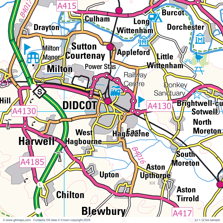
Didcot & surrounding area

Explore the full 60 × 60 km Didcot regional road map at 1:250,000, covering Didcot, Thatcham, Wantage, Newbury, Wallingford. Compare the complete coverage below; a detailed PDF sample is available free.

DIDCOT & SURROUNDING AREAREGIONAL ROAD MAP
60 × 60 km · Full map previewDownload the free SVG ↓

INSIDE THE FULL 60 × 60 KM MAP

Explore the Didcot map area

1:250,000 cartography

Towns, villages & places

More mapped places (340)
  • Beedon
  • Stanmore
  • West Ilsley
  • Catmore
  • Peasemore
  • Aldworth
  • Chilton
  • Chieveley
  • Blewbury
  • Farnborough
  • Hermitage
  • Upton
  • Brightwalton
  • Ashampstead
  • Leckhampstead
  • Yattendon
  • Longlane
  • Frilsham
  • East Ginge
  • Curridge
  • West Ginge
  • Chaddleworth
  • Harwell
  • Winterbourne
  • Streatley
  • Moulsford
  • Goring
  • Ashmore Green
  • South Stoke
  • Cold Ash
  • Ardington
  • Fawley
  • Bucklebury
  • Cholsey
  • Milton Hill
  • Boxford
  • Welford
  • Bagnor
  • Weston
  • Steventon
  • Milton
  • Bradfield
  • North Stoke
  • Wickham Heath
  • Stockcross
  • Wickham
  • Southend
  • Cray's Pond
  • Whitchurch-on-Thames
  • Midgham
  • Pangbourne
  • Ipsden
  • Grove
  • Tidmarsh
  • Beenham
  • Drayton
  • Woodcote
  • Crowmarsh Gifford
  • Greenham
  • Halfway
  • Englefield
  • Woolhampton
  • Culham
  • East Hanney
  • Enborne
  • Sulham
  • Eastbury
  • West Challow
  • Childrey
  • Shillingford
  • Newtown
  • Dorchester
  • Brimpton
  • Crookham
  • Benson
  • Denchworth
  • Warborough
  • Sparsholt
  • Burcot
  • Marcham
  • Mapledurham
  • Lambourn
  • Wasing
  • Aldermaston
  • Sulhamstead
  • Avington
  • Headley
  • Kintbury
  • Garford
  • Berinsfield
  • Lyford
  • Padworth
  • Frilford
  • Shippon
  • Roke
  • Nuffield
  • Ewelme
  • Goosey
  • Burghclere
  • Ecchinswell
  • Radley
  • Aldermaston Soke
  • Tubney
  • Inkpen
  • Cothill
  • Newington
  • Burghfield
  • West Woodhay
  • Highclere
  • Fyfield
  • East End
  • Marsh Baldon
  • Baughurst
  • Sunningwell
  • Highmoor
  • Upper Green
  • Chiselhampton
  • Baulking
  • Whitway
  • Bayworth
  • Nettlebed
  • Wootton
  • Stadhampton
  • Kingsclere
  • Uffington
  • Mortimer
  • Chalgrove
  • Baydon
  • Hatford
  • Caversham
  • Wolverton
  • Pusey
  • Silchester
  • Woolstone
  • Appleton
  • Longworth
  • Old Burghclere
  • Sydmonton
  • Kennington
  • Henwood
  • Whittonditch
  • Cuxham
  • Greys Green
  • Shellingford
  • Combe
  • Bix
  • West Heath
  • Froxfield
  • Bagshot
  • Easington
  • Garsington
  • Buckland
  • Eaton
  • Maidensgrove
  • Grazeley
  • Fernham
  • Ham
  • Aldbourne
  • Ashbury
  • Ashmansworth
  • Ramsbury
  • Greenfield
  • Northmoor
  • Ramsdell
  • Denton
  • Cumnor
  • Idstone
  • Faccombe
  • Buttermere
  • Pyrton
  • Pishill
  • Hannington
  • Little Haseley
  • Cuddesdon
  • Longcot
  • Beech Hill
  • Stonor
  • Little Bedwyn
  • Chimney
  • Littleworth
  • Standlake
  • Shalbourne
  • Shirburn
  • Shifford
  • Bishopstone
  • Bramley
  • Horspath
  • Rivar
  • Linkenholt
  • Great Haseley
  • Stratfield Saye
  • Sonning
  • Chisbury
  • Harpsden
  • Ibworth
  • Fawley
  • Brighthampton
  • Shinfield
  • Litchfield
  • Shiplake
  • Northend
  • Bramley Green
  • Swallowfield
  • Cote
  • Great Bedwyn
  • Remenham
  • Watchfield
  • Shrivenham
  • Wheatley
  • Farmoor
  • Sutton
  • Charvil
  • Adwell
  • Bourton
  • Riseley
  • Lewknor
  • Binley
  • Milton Common
  • Aston
  • Greenlands
  • Woodsend
  • Arborfield
  • Axford
  • Yelford
  • Upton
  • Fosbury
  • Holton
  • Hardwick
  • Oxenwood
  • Wargrave
  • Aston
  • Tetsworth
  • Ibstone
  • Wytham
  • Postcombe
  • Turgis Green
  • Turville
  • Ibthorpe
  • Swinford
  • Twyford
  • Wanborough
  • Waterstock
  • Hambleden
  • Radcot
  • Church End
  • Skirmett
  • Weald
  • Marten
  • Tiddington
  • Crofton
  • Sindlesham
  • Waterperry
  • Liddington
  • Wilton
  • Farley Hill
  • Bampton
  • Winnersh
  • Fingest
  • Wolvercote
  • Heckfield
  • Stoke
  • Coleshill
  • Ruscombe
  • Eynsham
  • Deane
  • Tidcombe
  • Hurst
  • Oakley
  • Durley
  • Stokenchurch
  • Clanfield
  • Wexcombe
  • Mildenhall
  • Bramshill
  • Barkham
  • Grafton
  • Sevenhampton
  • Ducklington
  • Frieth
  • Ickford
  • Lew
  • Crowell
  • Moreton
  • Kelmscott
  • Worminghall
  • Shabbington
  • Sydenham
  • Rotherwick
  • Hazeley
  • Cadley
  • Mattingley
  • Tangley
  • Buscot
  • Chute Standen
  • Eversley
  • Wildhern
  • Emmington
  • Burbage
  • Newnham
  • Chinnor
  • Curbridge
  • Hatherden
  • Alvescot
  • The City
  • Radnage
  • Langford
  • Finchampstead
  • Hook
  • Up Nately
  • Mapledurwell
  • West Green
  • Broadwell
  • Towersey
  • Brunton
  • Henton
  • Kencot
  • Aughton
  • Hartfordbridge
  • Forty Green
  • Bledlow
  • Filkins
  • Greywell
  • Pitch Green
  • Kingsey
  • Winchfield
  • Saunderton
  • Shilton
  • Ilmer
  • Haddenham
  • Odiham
  • Aston Sandford
  • Fyfield
  • Longwick
  • Bradwell
  • Owlswick
  • Dogmersfield
  • Everleigh
  • Holwell
  • Ford
  • Mill Lane

Roads across this sheet

M3, M4, M40, A4, A30, A33, A40, A287, A321, A323, A327, A329, A329(M), A338, A339, A340, A342, A343, A346, A361, A415, A417, A418, A420

More road numbers

A423, A3010, A3026, A3032, A3290, A4074, A4095, A4129, A4130, A4142, A4144, A4155, A4158, A4165, A4183, A4185, B471, B477, B478, B480, B481, B482, B3011, B3016, B3018, B3024, B3030, B3031, B3046, B3048, B3051, B3087, B3270, B3272, B3345, B3348, B3349, B3350, B3400, B3421, B3430, B4000, B4001, B4009, B4011, B4012, B4015, B4016, B4017, B4019, B4020, B4022, B4027, B4044, B4150, B4192, B4444, B4445, B4446, B4449, B4477, B4493, B4494, B4495, B4507, B4508, B4526, B4640

Rivers & waterways

Abbey Stream, Back Water, Basingstoke Canal, Blackwater River, Clifton Cut, Culham Cut, Holy Brook, Kennet & Avon Canal, Oxford Canal, River Avon, River Bourne, River Cherwell

More waterways

River Coln, River Evenlode, River Hart, River Kennet, River Lambourn, River Leach, River Loddon, River Ock, River Pang, River Test, River Thame, River Thames, River Thames or Isis, River Whitewater, River Windrush, Wilts & Berks Canal (disused)

Landmarks & landscape

21 South Street Arts Centre, 4 Kingdoms Adventure Park, Abingdon Abbey, Abingdon County Hall, Abingdon Museum, Aldermaston Wharf Canal Visitor Centre, Ashdown House, Ashmolean Museum & Archeology, Ashmolean, Museum of Natural History, Modern Art, Museum of Oxford, Bate Collection, Pitt Rivers Museum, BT, The Oxford Story, History of Science, Aston Rowant, Basildon House and Park, Basing House

More named features

Beale Park Wildlife Park, Blackbushe, Bledlow Cross (Hill Figure), Bucklebury Common Nature Reserve, Bucklebury Farm Park, Buscot Park, CALLEVA, California Country Park, Calleva Museum, Calleva Roman Town Wall, Calleva Roman Town Amphitheatre, Champ's Chapel and Museum, Chapel, Chiltern Valley Winery & Brewery, Chinnor Hill Nature Reserve, Chisbury Chapel - St Martin's Chapel, Chisbury Chapel/St Martin's Chapel, Cholsey and Wallingford Railway, Christchurch Cathedral, Cogges Manor Farm Museum, Witney and District Museum, Conduit House, Cotswold Wildlife Park, Cotswold Woollen Weavers, Courthouse, Crofton Beam Engines, Didcot Railway Centre, Dinton Pastures Country Park, Donnington Castle, Donnington Castle (remains of), Dorchester Abbey Museum, Englefield Garden, Farmer Gow's, Friar's Court House and Garden, Great Coxwell Barn, Greenham and Crookham Nature Reserve, Greys Court, Haddenham Museum, Hampden's Monument, Harcourt Aboretum and Garden, Herb Farm and Maze, Herbert Plantation, Highclere Castle, Highclere Park Gardens, Icknield Line Steam Railway, Inkpen Common Nature Reserve, Inkpen Long Barrow, Island Farm Donkey Sanctuary, Kelmscott Manor, Kencot Hill Solar Farm, Kingston Bagpuize House, Kingston Blount Point to Point Racecourse, Linch Hill Leisure Park, Little Wittenham Nature Reserve, Littlecote, Long Crendon Courthouse, Ludgershall Castle, Ludgershall Castle and Cross, Maharajah's Well, Mapledurham House, Mapledurham Watermill, Milestones Living History Museum, Milton Manor, Museum, Museum of Berkshire Aviation, Museum of Reading, Blakes Lock Museum, Museum of English Rural Life, Newbury Racecourse, Newbury Showground, Nuffield Place, Odiham Castle, Old Kiln, Oxford & Buckinghamshire Light Infantry Museum, Oxford Castle, Oxford University Botanic Gardens, Oxfordshire Museums Resource Centre, Pendon Museum, Pierces Solar Farm, R.E.M.E Museum, Radcliffe Camera, Oxford Castle, Richardson/Amey Nature Reserve, River and Rowing Museum, Roves Farm, Rycote Chapel, Sandham Memorial Chapel, Shotover Country Park, Snelsmore Common Country Park, Solar Farm, St Tiggywinkles, Stonor House, Stratfield Saye House, Thatcham Reed Beds, The Living Rainforest, The Pottery, The Swinford Museum, The Vyne, Tom Brown's School Museum, Uffington Castle, Uffington White Horse, Uffington White Horse (Hill Figure), Vale & Downland Museum, Ven Mill, Wallingford Museum, Wanborough Nature Reserve, Warburg Nature Reserve, Waterperry Gardens, Watlington Hill, Wayland's Smithy, Wayland's Smithy Chambered Long Barrow, Welford Park Gardens, Wellington Country Park, West Berkshire Museum, West Green House Garden, Willis Museum, Wilton Windmill, Wooley House
Local authority & parish coverage

Wholly or partly within the full map rectangle. These boundaries are coverage information, not additional artwork layers.

  • Basingstoke and Deane DistrictPartly within
  • BuckinghamshirePartly within
  • Cherwell DistrictPartly within
  • Cotswold DistrictPartly within
  • Hart DistrictPartly within
  • Oxford DistrictPartly within
  • ReadingWholly within
  • South Oxfordshire DistrictPartly within
  • SwindonPartly within
  • Test Valley DistrictPartly within
  • Vale of White Horse DistrictPartly within
  • West BerkshireWholly within
  • West Oxfordshire DistrictPartly within
  • WiltshirePartly within
  • Windsor and MaidenheadPartly within
  • WokinghamPartly within
Wards & electoral divisions 190 areas
  • Abbey Ward
  • Abingdon Abbey Northcourt Ward
  • Abingdon Caldecott Ward
  • Abingdon Dunmore Ward
  • Abingdon Fitzharris Ward
  • Abingdon Peachcroft Ward
  • Aldermaston Ward
  • Alvescot and Filkins Ward (part)
  • Bampton and Clanfield Ward
  • Barkham & Arborfield Ward
  • Barton & Sandhills Ward
  • Basildon Ward
  • Basing & Upton Grey Ward (part)
  • Battle Ward
  • Bellinger Ward (part)
  • Benson & Crowmarsh Ward
  • Berinsfield Ward
  • Blackbird Leys Ward
  • Blewbury & Harwell Ward
  • Botley & Sunningwell Ward (part)
  • Bourne Valley Ward (part)
  • Bradfield Ward
  • Bramley Ward
  • Brighton Hill Ward (part)
  • Brize Norton and Shilton Ward (part)
  • Brookvale & Kings Furlong Ward
  • Bucklebury Ward
  • Bulmershe & Coronation Ward
  • Burford Ward (part)
  • Burghfield & Mortimer Ward
  • Carfax & Jericho Ward
  • Carterton North East Ward
  • Carterton North West Ward
  • Carterton South Ward
  • Caversham Heights Ward
  • Caversham Ward
  • Chalgrove Ward
  • Charlton & the Pentons Ward (part)
  • Chieveley & Cold Ash Ward
  • Chiltern Villages Ward (part)
  • Chineham Ward
  • Chinnor Ward
  • Chiseldon & Ridgeway Ward (part)
  • Cholsey Ward
  • Church Ward
  • Churchill Ward
  • Coley Ward
  • Coln Valley Ward (part)
  • Cowley Ward
  • Crookham West and Ewshot Ward (part)
  • Cumnor Ward
  • Cutteslowe & Sunnymead Ward (part)
  • Didcot North East Ward
  • Didcot South Ward
  • Didcot West Ward
  • Donnington Ward
  • Downlands Ward
  • Drayton Ward
  • Ducklington Ward (part)
  • Eastrop & Grove Ward
  • Emmbrook Ward (part)
  • Emmer Green Ward
  • Evendons Ward (part)
  • Evingar Ward (part)
  • Eynsham and Cassington Ward (part)
  • Faringdon Ward
  • Finchampstead Ward (part)
  • Fleet Central Ward (part)
  • Fleet West Ward (part)
  • Forest Hill & Holton Ward (part)
  • Garsington & Horspath Ward
  • Goring Ward
  • Grove North Ward
  • Haddenham & Stone Ward (part)
  • Hailey, Minster Lovell and Leafield Ward (part)
  • Hartley Wintney Ward (part)
  • Haseley Brook Ward
  • Hawkedon Ward
  • Headington Hill & Northway Ward
  • Headington Ward
  • Hendreds Ward
  • Henley-on-Thames Ward
  • Highworth Ward (part)
  • Hillside Ward
  • Hinksey Park Ward
  • Holywell Ward
  • Hook Ward
  • Hungerford & Kintbury Ward
  • Hurley & Walthams Ward (part)
  • Katesgrove Ward
  • Kempshott & Buckskin Ward (part)
  • Kennington & Radley Ward
  • Kentwood Ward
  • Kidlington East Ward (part)
  • Kidmore End & Whitchurch Ward
  • Kingston Bagpuize Ward
  • Lambourn Ward
  • Lechlade, Kempsford & Fairford South Ward (part)
  • Littlemore Ward
  • Loddon Ward
  • Long Crendon Ward (part)
  • Lye Valley Ward
  • Maiden Erlegh & Whitegates Ward
  • Marcham Ward
  • Marston Ward
  • Newbury Central Ward
  • Newbury Clay Hill Ward
  • Newbury Greenham Ward
  • Newbury Speen Ward
  • Newbury Wash Common Ward
  • Norcot Ward
  • Norden Ward
  • Northfield Brook Ward
  • Northleach Ward (part)
  • Oakley & The Candovers Ward (part)
  • Odiham Ward (part)
  • Osney & St Thomas Ward
  • Pangbourne Ward
  • Park Ward
  • Popley Ward
  • Princes Risborough Ward (part)
  • Quarry & Risinghurst Ward
  • Redlands Ward
  • Ridgeway East Ward (part)
  • Ridgeway Ward
  • Ridgeway Ward
  • Ridgeway West Ward (part)
  • Rose Hill & Iffley Ward
  • Sandford & the Wittenhams Ward
  • Sherborne St. John & Rooksdown Ward
  • Shinfield Ward
  • Sonning Common Ward
  • South Ham Ward
  • South Lake Ward
  • South Marston Ward (part)
  • Southcote Ward
  • Spencers Wood & Swallowfield Ward
  • St. Clement's Ward
  • St. Mary's Ward
  • Standlake, Aston and Stanton Harcourt Ward
  • Stanford Ward
  • Steventon & the Hanneys Ward
  • Summertown Ward
  • Sutton Courtenay Ward
  • Tadley & Pamber Ward
  • Tadley North, Kingsclere & Baughurst Ward
  • Temple Cowley Ward
  • Thame Ward
  • Thames Ward
  • Thames Ward (part)
  • Thames Ward
  • Thatcham Central Ward
  • Thatcham Colthrop & Crookham Ward
  • Thatcham North East Ward
  • Thatcham West Ward
  • Theale Ward
  • Tilehurst & Purley Ward
  • Tilehurst Birch Copse Ward
  • Tilehurst South & Holybrook Ward
  • Tilehurst Ward
  • Twyford, Ruscombe & Hurst Ward (part)
  • Waddesdon Ward (part)
  • Wallingford Ward
  • Walton Manor Ward
  • Wantage & Grove Brook Ward
  • Wantage Charlton Ward
  • Watchfield & Shrivenham Ward
  • Watlington Ward
  • West Wycombe & Lane End Ward (part)
  • Wheatley Ward
  • Whitchurch, Overton & Laverstoke Ward (part)
  • Whitley Ward
  • Winklebury & Manydown Ward
  • Winnersh Ward (part)
  • Witney Central Ward (part)
  • Witney East Ward (part)
  • Witney South Ward
  • Witney West Ward (part)
  • Wolvercote Ward (part)
  • Woodcote & Rotherfield Ward
  • Wootton Ward
  • Yateley West Ward (part)
  • Aldbourne & Ramsbury ED (part)
  • Avon Valley ED (part)
  • Ludgershall North & Rural ED (part)
  • Marlborough East ED (part)
  • Pewsey ED (part)
  • Pewsey Vale East ED
  • Tidworth East & Ludgershall South ED (part)
  • Tidworth North & West ED (part)
Civil parishes & communities 405 areas
  • Abingdon on Thames CP
  • Adwell CP
  • Aldbourne CP (part)
  • Aldermaston CP
  • Aldworth CP
  • Alvescot CP
  • Appleford-on-Thames CP
  • Appleshaw CP (part)
  • Appleton-with-Eaton CP
  • Arborfield and Newland CP
  • Ardington CP
  • Ashampstead CP
  • Ashbury CP
  • Ashford Hill with Headley CP
  • Ashmansworth CP
  • Asthall CP (part)
  • Aston Rowant CP
  • Aston Sandford CP
  • Aston Tirrold CP
  • Aston Upthorpe CP
  • Aston, Cote, Shifford and Chimney CP
  • Bampton CP
  • Barkham CP
  • Barrington CP (part)
  • Basildon CP
  • Baughurst CP
  • Baulking CP
  • Baydon CP
  • Beckley and Stowood CP (part)
  • Beech Hill CP
  • Beedon CP
  • Beenham CP
  • Benson CP
  • Berinsfield CP
  • Berrick Salome CP
  • Besselsleigh CP
  • Binfield Heath CP
  • Bishopstone CP
  • Bix and Assendon CP
  • Black Bourton CP
  • Blackbird Leys CP
  • Bledlow-cum-Saunderton CP (part)
  • Blewbury CP
  • Botley and North Hinksey CP
  • Bourton CP
  • Boxford CP
  • Bradfield CP
  • Bramley CP
  • Bramshill CP
  • Brightwalton CP
  • Brightwell Baldwin CP
  • Brightwell-cum-Sotwell CP
  • Brimpton CP
  • Britwell Salome CP
  • Brize Norton CP (part)
  • Broadwell CP
  • Buckland CP
  • Bucklebury CP
  • Burbage CP
  • Burford CP (part)
  • Burghclere CP
  • Burghfield CP
  • Buscot CP
  • Buttermere CP
  • Carterton CP
  • Cassington CP (part)
  • Catmore CP
  • Chaddleworth CP
  • Chalgrove CP
  • Charney Bassett CP
  • Charvil CP
  • Chearsley CP (part)
  • Checkendon CP
  • Chieveley CP
  • Childrey CP
  • Chilton CP (part)
  • Chilton CP
  • Chilton Foliat CP
  • Chineham CP
  • Chinnor CP
  • Chiseldon CP (part)
  • Cholsey CP
  • Chute CP
  • Chute Forest CP (part)
  • Clanfield CP
  • Cliddesden CP (part)
  • Clifton Hampden CP
  • Cold Ash CP
  • Coleshill CP
  • Collingbourne Ducis CP
  • Collingbourne Kingston CP
  • Combe CP
  • Compton Beauchamp CP
  • Compton CP
  • Crondall CP (part)
  • Crookham Village CP (part)
  • Crowell CP
  • Crowmarsh CP
  • Cuddesdon and Denton CP
  • Cuddington CP (part)
  • Culham CP
  • Cumnor CP
  • Curbridge CP (part)
  • Cuxham with Easington CP
  • Deane CP (part)
  • Denchworth CP
  • Didcot CP
  • Dinton-with-Ford and Upton CP (part)
  • Dogmersfield CP
  • Dorchester CP
  • Drayton CP
  • Drayton St. Leonard CP
  • Ducklington CP
  • Earley CP
  • East Challow CP
  • East Garston CP
  • East Hagbourne CP
  • East Hanney CP
  • East Hendred CP
  • East Ilsley CP
  • East Woodhay CP
  • Eastleach CP (part)
  • Easton CP (part)
  • Eaton Hastings CP
  • Ecchinswell, Sydmonton and Bishops Green CP
  • Elsfield CP (part)
  • Elvetham Heath CP (part)
  • Enborne CP
  • Englefield CP
  • Enham Alamein CP (part)
  • Everleigh CP (part)
  • Eversley CP (part)
  • Ewelme CP
  • Eye and Dunsden CP
  • Eynsham CP (part)
  • Faccombe CP
  • Farnborough CP
  • Fawley CP
  • Fawley CP
  • Fernham CP
  • Filkins and Broughton Poggs CP
  • Finchampstead CP (part)
  • Fittleton cum Haxton CP (part)
  • Fleet CP (part)
  • Forest Hill with Shotover CP
  • Frilford CP
  • Frilsham CP
  • Froxfield CP
  • Fyfield and Tubney CP
  • Garford CP
  • Garsington CP
  • Goosey CP
  • Goring Heath CP
  • Goring-on-Thames CP
  • Gosford and Water Eaton CP (part)
  • Grafton CP
  • Grafton and Radcot CP
  • Great Bedwyn CP
  • Great Coxwell CP
  • Great Faringdon CP
  • Great Haseley CP
  • Great Milton CP
  • Great Shefford CP
  • Great and Little Kimble cum Marsh CP (part)
  • Greenham CP
  • Greywell CP (part)
  • Grove CP
  • Haddenham CP (part)
  • Ham CP
  • Hambleden CP (part)
  • Hampstead Marshall CP
  • Hampstead Norreys CP
  • Hannington CP
  • Hardwick-with-Yelford CP
  • Harpsden CP
  • Hartley Wespall CP
  • Hartley Wintney CP (part)
  • Harwell CP
  • Hatford CP
  • Heckfield CP
  • Henley-on-Thames CP
  • Hermitage CP
  • Highclere CP
  • Highmoor CP
  • Highworth CP (part)
  • Hinton Waldrist CP
  • Holton CP
  • Holwell CP
  • Holybrook CP
  • Hook CP
  • Horspath CP
  • Hungerford CP
  • Hurley CP (part)
  • Hurstbourne Priors CP (part)
  • Hurstbourne Tarrant CP
  • Ibstone CP
  • Ickford CP
  • Inglesham CP (part)
  • Inkpen CP
  • Ipsden CP
  • Kelmscott CP
  • Kempsford CP (part)
  • Kencot CP
  • Kennington CP
  • Kidmore End CP
  • Kimpton CP (part)
  • Kingsclere CP
  • Kingsey CP
  • Kingston Bagpuize with Southmoor CP
  • Kingston Lisle CP
  • Kintbury CP
  • Lambourn CP
  • Lane End CP (part)
  • Langford CP
  • Lechlade CP (part)
  • Leckhampstead CP
  • Letcombe Bassett CP
  • Letcombe Regis CP
  • Lew CP
  • Lewknor CP
  • Liddington CP (part)
  • Linkenholt CP
  • Litchfield and Woodcott CP
  • Little Bedwyn CP
  • Little Coxwell CP
  • Little Faringdon CP
  • Little Milton CP
  • Little Wittenham CP
  • Littlemore CP
  • Littleworth CP
  • Lockinge CP
  • Long Crendon CP (part)
  • Long Wittenham CP
  • Longcot CP
  • Longwick-cum-Ilmer CP (part)
  • Longworth CP
  • Ludgershall CP (part)
  • Lyford CP
  • Mapledurham CP
  • Mapledurwell and Up Nately CP (part)
  • Marcham CP
  • Marlborough CP (part)
  • Marsh Baldon CP
  • Mattingley CP
  • Medmenham CP (part)
  • Midgham CP
  • Mildenhall CP (part)
  • Milton CP
  • Milton Lilbourne CP (part)
  • Minster Lovell CP (part)
  • Monk Sherborne CP
  • Mortimer West End CP
  • Moulsford CP
  • Nettlebed CP
  • Newbury CP
  • Newington CP
  • Newnham CP
  • Newtown CP
  • North Moreton CP
  • Northmoor CP
  • Nuffield CP
  • Nuneham Courtenay CP
  • Oakley CP (part)
  • Oakley CP (part)
  • Odiham CP (part)
  • Ogbourne St. Andrew CP (part)
  • Ogbourne St. George CP (part)
  • Old Basing and Lychpit CP
  • Old Marston CP
  • Overton CP (part)
  • Padworth CP
  • Pamber CP
  • Pangbourne CP
  • Peasemore CP
  • Penton Grafton CP (part)
  • Piddington and Wheeler End CP (part)
  • Pishill with Stonor CP
  • Princes Risborough CP (part)
  • Purley on Thames CP
  • Pusey CP
  • Pyrton CP
  • Radley CP
  • Radnage CP (part)
  • Ramsbury CP
  • Remenham CP (part)
  • Risinghurst and Sandhills CP
  • Rooksdown CP
  • Rotherfield Greys CP
  • Rotherfield Peppard CP
  • Rotherwick CP
  • Ruscombe CP (part)
  • Sandford-on-Thames CP
  • Savernake CP (part)
  • Shabbington CP
  • Shalbourne CP
  • Shaw cum Donnington CP
  • Shellingford CP
  • Sherborne St. John CP
  • Sherfield Park CP
  • Sherfield on Loddon CP
  • Shilton CP (part)
  • Shinfield CP
  • Shiplake CP
  • Shirburn CP
  • Shrivenham CP
  • Silchester CP
  • Smannell CP (part)
  • Sonning CP
  • Sonning Common CP
  • South Hinksey CP
  • South Leigh and High Cogges CP (part)
  • South Marston CP (part)
  • South Moreton CP
  • South Stoke CP
  • South Warnborough CP (part)
  • Southrop CP (part)
  • Sparsholt CP
  • Speen CP
  • St. Helen Without CP
  • St. Mary Bourne CP (part)
  • St. Nicholas, Hurst CP (part)
  • Stadhampton CP
  • Standlake CP
  • Stanford Dingley CP
  • Stanford in the Vale CP
  • Stanton Harcourt CP
  • Stanton St. John CP (part)
  • Steventon CP
  • Stoke Row CP
  • Stoke Talmage CP
  • Stokenchurch CP
  • Stone with Bishopstone and Hartwell CP (part)
  • Stratfield Mortimer CP
  • Stratfield Saye CP
  • Stratfield Turgis CP
  • Streatley CP
  • Sulham CP
  • Sulhamstead CP
  • Sunningwell CP
  • Sutton Courtenay CP
  • Swallowfield CP
  • Swyncombe CP
  • Sydenham CP
  • Tadley CP
  • Tangley CP (part)
  • Tetsworth CP
  • Thame CP
  • Thatcham CP
  • Theale CP
  • Tidcombe and Fosbury CP
  • Tiddington-with-Albury CP
  • Tidmarsh CP
  • Tidworth CP (part)
  • Tilehurst CP
  • Toot Baldon CP
  • Towersey CP
  • Tunworth CP (part)
  • Turville CP
  • Twyford CP
  • Uffington CP
  • Ufton Nervet CP
  • Upton CP
  • Upton Grey CP (part)
  • Vernhams Dean CP
  • Wallingford CP
  • Wanborough CP (part)
  • Wantage CP
  • Warborough CP
  • Wargrave CP (part)
  • Wasing CP
  • Watchfield CP
  • Waterperry with Thomley CP (part)
  • Waterstock CP
  • Watlington CP
  • Welford CP
  • West Challow CP
  • West Hagbourne CP
  • West Hanney CP
  • West Hendred CP
  • West Ilsley CP
  • West Woodhay CP
  • Western Valley CP
  • Westwell CP (part)
  • Wheatfield CP
  • Wheatley CP
  • Whitchurch CP (part)
  • Whitchurch-on-Thames CP
  • Winchfield CP
  • Winnersh CP (part)
  • Winslade CP (part)
  • Winterbourne CP
  • Witney CP (part)
  • Wokefield CP
  • Wokingham CP (part)
  • Woodcote CP
  • Woodley CP
  • Woolhampton CP
  • Woolstone CP
  • Wootton CP
  • Wootton Rivers CP (part)
  • Wootton St. Lawrence with Ramsdell CP
  • Worminghall CP (part)
  • Wytham CP (part)
  • Yateley CP (part)
  • Yattendon CP

Source: the GBMaps road atlas, OS Boundary-Line and postcode mapping datasets. Source editions are being checked for publication. Unmarked boundary names are wholly within the sheet; “part” means the map edge crosses the area.

Place lists are selected from the map source, not a complete gazetteer. Named features describe the cartography; visitor facilities and opening status are not verified. The free sample covers only 12 × 12 km of this larger sheet.

INSIDE YOUR DOWNLOAD

A proper road map, in useful formats

Road classifications, towns and villages, railways, rivers, landscape detail and tourist symbols, brought together in the GBMaps regional road atlas style.

PDF filePDFSVG fileSVGAdobe Illustrator AI fileAi

PDF for the finished map. SVG and layered Illustrator artwork for adapting colours, adding your own information and preparing designs.

THE FINISHED SHEET

Designed for print and presentation

Map coverage
60 × 60 km
Sample coverage
12 × 12 km
Print layout
A3 landscape · enlarged 1:250k cartography
Sheet furniture
Border, scale bar, key & north arrow

A few useful details

What changes when I select another square?

Select a surrounding square to bring it into the centre and reveal the maps around it. Each square is a different 60 × 60 km map. The preview, free sample and selected download change together. Neighbouring sheets overlap by 30 km so you can choose the coverage that suits you.

Is the free sample a vector map?

The on-page detail is an SVG. The free download is a separate 12 × 12 km PDF with a link to the full map. Please retain its copyright credits and product link when sharing it.

Can I buy a larger combined map?

These downloads are individual ready-made sheets. Contact GBMaps if you need a larger combined area.

FREE PDF SAMPLE

Your free map sample

Your free 12 × 12 km sample includes a link back to this map, so you can return for the full area whenever you need it.

Download free PDF sample ↓

Get your Didcot map

Map download bundle

£24.00including VATOne payment

Pay securely

One payment. Your map stays open.

Your map download

Your map files

Preparing your download…

Checking your private download link…

Your map downloads

Already bought a map?

Find the downloads from your purchases.

Enter the email address you used at checkout. We’ll email you a private link to your available map downloads.