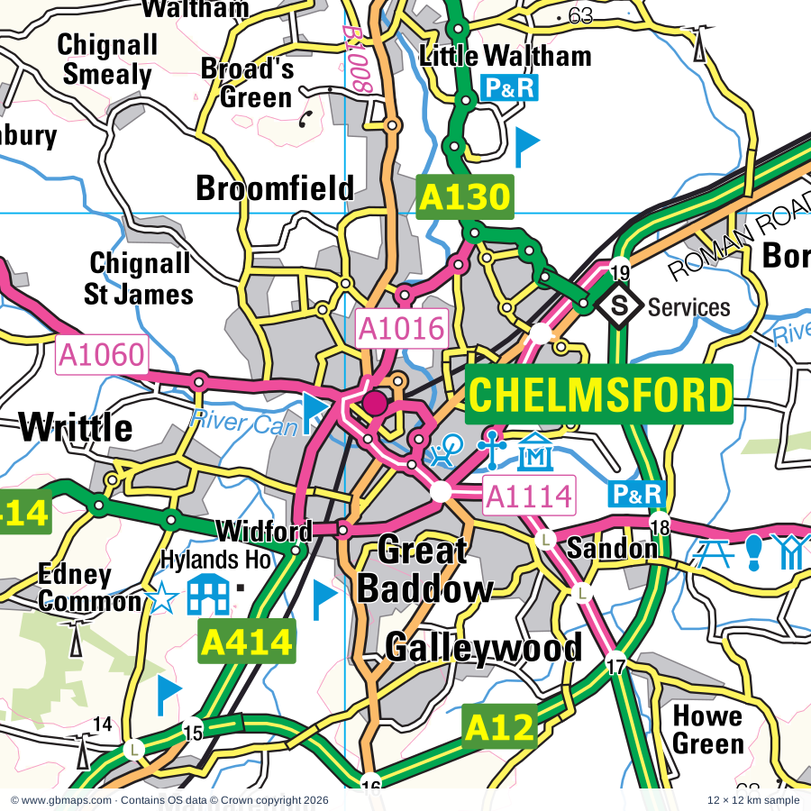
Chelmsford regional road map. Full 60 × 60 km PDF, SVG and Illustrator files, with a free PDF sample.

GBMAPS.COM

Chelmsford Regional Road Map

Call Us Now for Help01751 473136

GREAT BRITAIN ROAD ATLAS · 1:250,000 GB-570-0210

Chelmsford & surrounding area

Explore the full 60 × 60 km Chelmsford regional road map at 1:250,000, covering Chelmsford, Colchester, Witham, Braintree, Billericay. Compare the complete coverage below; a detailed PDF sample is available free.

CHELMSFORD & SURROUNDING AREAREGIONAL ROAD MAP
60 × 60 km · Full map previewDownload the free SVG ↓

INSIDE THE FULL 60 × 60 KM MAP

Explore the Chelmsford map area

1:250,000 cartography

Towns, villages & places

More mapped places (211)
  • Chigwell
  • Broomfield
  • Little Waltham
  • Writtle
  • Mashbury
  • Roxwell
  • Pleshey
  • Boreham
  • Sandon
  • Galleywood
  • Ford End
  • Loves Green
  • Terling
  • Margaretting
  • North End
  • Danbury
  • Fairstead
  • Nounsley
  • Ulting
  • Felsted
  • Willingale
  • Stock
  • Beggar Hill
  • Fryerning
  • Ingatestone
  • Bicknacre
  • Barnston
  • Faulkbourne
  • Blackmore
  • Bacon End
  • Rayne
  • Fyfield
  • Rettendon
  • Hazeleigh
  • Langford
  • Brock Hill
  • Woodham Ferrers
  • Downham
  • White Roding
  • Cressing
  • Mountnessing
  • Silver End
  • Wyatt's Green
  • Stebbing
  • Little Laver
  • Doddinghurst
  • Panfield
  • Purleigh
  • Runwell
  • Great Canney
  • Bradwell
  • Great Braxted
  • Duck End
  • Moreton
  • Bobbingworth
  • Battlesbridge
  • Great Totham
  • Heybridge Basin
  • Greensted
  • High Garrett
  • Takeley
  • Stisted
  • Kelvedon
  • Matching
  • Pattiswick
  • Lindsell
  • Rawreth
  • Mundon
  • Hullbridge
  • Oxen End
  • Shalford
  • Ingrave
  • Sheering
  • Inworth
  • Toot Hill
  • North Fambridge
  • Feering
  • Goldhanger
  • Herongate
  • Bedlar's Green
  • Tiptree
  • Latchingdon
  • Broxted
  • Wethersfield
  • Tolleshunt Knights
  • Gosfield
  • Messing
  • Hastingwood
  • Chickney
  • Maylandsea
  • Spellbrook
  • Hockley
  • Childerditch
  • Finchingfield
  • Great Warley
  • Birchanger
  • Thundersley
  • Mayland
  • Elsenham
  • Hawkwell
  • Althorne
  • Ashingdon
  • Daws Heath
  • High Wych
  • Henham
  • Layer Marney
  • Easthorpe
  • Steeple
  • Ugley Green
  • Earls Colne
  • Bulphan
  • Great Tey
  • Hazel End
  • Gilston
  • Hadleigh
  • Fobbing
  • Canewdon
  • Hardy's Green
  • Colne Engaine
  • Tollesbury
  • Ramsey Island
  • Delvin End
  • Swan Street
  • Birch
  • Ugley
  • Copford
  • Eastwick
  • Manuden
  • Chappel
  • Green Tye
  • Abridge
  • Aldham
  • Widdington
  • Farnham
  • Ostend
  • Heckfordbridge
  • St Lawrence
  • Upminster
  • Debden
  • Toppesfield
  • Leigh-on-Sea
  • Quendon
  • Stoneyhills
  • Romford
  • Pebmarsh
  • Fordstreet
  • Hunsdon
  • Hunsdonbury
  • Orsett
  • Asheldham
  • Wimbish
  • Hempstead
  • Nazeing
  • Chigwell Row
  • Stambourne
  • Mucking
  • Widford
  • Radwinter
  • Southfields
  • Roydon
  • Rickling
  • Fordham
  • Upshire
  • Peldon
  • Newport
  • Tillingham
  • Dengie
  • Berden
  • Albury End
  • Albury
  • Barling
  • Gestingthorpe
  • Alphamstone
  • Twinstead
  • Sewards End
  • Clavering
  • Wormingford
  • Bures
  • Braughing Friars
  • Lamarsh
  • Dagenham
  • Aveley
  • Arkesden
  • Bures Green
  • Ford End
  • Rainham
  • Wennington
  • Middleton
  • Woodford
  • Shoeburyness
  • Meesden
  • Littlebury
  • Wissington
  • Ilford
  • Little Cornard
  • Langley
  • Duddenhoe End
  • Honey Tye
  • Sackers Green
  • Barking
  • Wanstead
  • Assington
  • Nayland
  • Strethall
  • Anstey
  • Leavenheath
  • Boxted
  • Elmdon
  • Chrishall
  • Nuthampstead
  • Polstead

Roads across this sheet

M11, M25, A12, A13, A104, A110, A112, A113, A114, A116, A117, A118, A120, A121, A123, A124, A125, A127, A128, A129, A130, A131, A132, A133

More road numbers

A134, A138, A176, A406, A414, A1008, A1009, A1012, A1013, A1014, A1015, A1016, A1017, A1019, A1020, A1023, A1025, A1059, A1060, A1069, A1083, A1089, A1099, A1112, A1114, A1124, A1153, A1158, A1159, A1160, A1168, A1169, A1184, A1199, A1235, A1240, A1245, A1250, A1251, A1306, A1400, A2016, A2041, B117, B148, B168, B170, B172, B173, B174, B175, B178, B180, B181, B182, B183, B184, B186, B187, B188, B192, B1002, B1004, B1006, B1007, B1008, B1009, B1010, B1012, B1013, B1014, B1015, B1016, B1017, B1018, B1019, B1021, B1022, B1023, B1024, B1025, B1026, B1036, B1038, B1039, B1051, B1052, B1053, B1054, B1055, B1057, B1068, B1087, B1133, B1137, B1256, B1335, B1351, B1368, B1383, B1389, B1393, B1408, B1417, B1418, B1419, B1420, B1421, B1459, B1464, B1508, B1529

Rivers & waterways

Chelmer & Blackwater Navigation, Cobbin's Brook, Langford Cut (canal), Pods Brook, River Ash, River Blackwater, River Brain, River Cam or Granta, River Can, River Chelmer, River Colne, River Crouch

More waterways

River Pant, River Stort, River Stour, River Ter, Roman River

Landmarks & landscape

Abberton Reservoir Nature Reserve, Asheldham Pits Nature Reserve, Audley End, Audley End Miniature Railway, Aythorpe Roding Postmill, BBC Essex Garden, Barleylands Craft Village, Barleylands Farm Centre, Barr Hall, Bay Museum, Beam Valley Country Park, Belhus Woods Country Park, and Belhus Woods Country Park Lakes Fishing Venue

More named features

Blake Hall, Blake House Craft Centre, Blake's Wood Nature Reserve, Bocking Windmill, Bouchiers Barn Visitor Centre, Bourne Mill, Roman Circus Centre, Boydell's Dairy Farm, Braintree District Museum and Heritage Centre, Warner Textile Collection, Brentwood Museum, Brentwood R C Cathedral, Bridge End Gardens and Maze, Brookes Nature Reserve, Burnham-On-Crouch District Museum, Burnham Town Quay Museum, Canvey Heights, Carters Vineyard, Carters Energy Project, Castle, Castle Point Transport Museum, Chalkney Wood Nature Reserve, Chelmsford Cathedral, Chelmsford City Racecourse, Chelmsford Museum & The Essex Regiment Museum, Essex Yeomanry Museum Collection, Sandford Mill Museum, Colchester Arts Centre, Balkerne Gate, Colchester Arts Centre, Colchester Zoo, Colne Valley Farm Park, Colne Valley Railway (Tourist Railway), Copt Hall, Cory Environmental Trust Visitor Centre, Cressing Temple Barns, Crossness Pumping Station, Danbury Common Nature Reserve, Danbury Country Park, Dunton Road Solar Farm, East Anglian Railway Museum, Eastbury Manor House, Epping Forest Centres, Epping Ongar Railway, ExCeL Exhibition Centre, Fairlop Waters Country Park, Faitkytes Arts Centre, Feering Museum, Feeringbury Manor Gardens, Felsted Vineyard, Festival Leisure Park, Finchingfield Guildhall, Finchingfield Postmill, Gibbard Garden, Gilston Park, Glen Chantry, Glendale Forge, Gosbecks Archaeological Park, Gosfield Hall, Grange Barn, Grangewaters Country Park, Great Bardfield Cage, Great Bardfield Cottage Museum, Great Notley, Great Stocks Vineyard, Green Visitor Centre, Hadleigh Castle, Hadleigh Castle 9rems of), Hadleigh Country Park, Hainault Forest Country Park, Hanningfield Reservoir Nature Reserve, Hatfield Forest Country Park, Havering Country Park, Havering Visitor Centre, Hedingham Castle, Henry Moore Foundation, Heritage Centre & Folk Museum, Dutch Cottage Museum, Highfields Solar Farm, Hill Hall, Hornchurch Country Park, Horndon on the Hill Woolmarket, House on the Hill Toy Museum, Hyde Hall Gardens, Hylands House, Ingatestone Hall, Ingrebourne Valley, Kelvedon Hatch Nuclear Secret Bunker, Knights Farm, Langdon Conservation Centre, Langdon Hills Country Park, Langdon Hills Country Park (Westley Heights), Langdon Nature Reserve, Langley Park Rally School, Layer Marney Tower, Leez Priory, Leigh Heritage Centre, Lexden Earthworks and Bluebottle Grove, Lexden Park Nature Reserve, Log Church, London Gateway Container Terminal, Maldon District Museum, Combined Military Services Museum, Maeldune Heritage Centre, Mangapps Farm Railway, Mangapps Railway Museum, Mardyke Valley Beauty Spot, Marina, Burnham Sailing Club, Mark Hall Cycle Museum & Gardens, Marks Hall Country Estate Aboretum, Marks Tey Point to Point Racecourse, Marsh Farm Country Park, Moulsham Mill, Mountfitchet Castle, Mountfitchet Castle and Norman Village, Mountnessing Windmill, Museum of Power, New Hall Vineyard, Noak Bridge Nature Reserve, Norsey Wood Nature Reserve, North Weald Airfield Museum and Memorial, Northey Island Nature Reserve, Old Gosfield Airfield Solar Farm, Old Leigh Studios, Old MacDonald's Educational Farm Park, Parndon Mill, Parndon Wood Nature Reserve, Patmore Heath Nature Reserve, Paycocke's, Peter Pan's Adventure Island, Pheasanthouse Wood Nature Reserve, Prior's Hall Barn, Prittlewell Priory, Queens Park Country Park, Rainham Hall, Rayleigh Mount, Rayleigh Museum, Red House Gardens, Redbridge Local History Museum, Redwings Horse Sanctuary, Rochford & District Off Road Centre, Roding Valley Meadows Nature Reserve, Rose Hill Farm Herb Garden, Saffron Walden Arts Centre, Saffron Walden Museum, Saling Hall Gardens, Shalom Hall, Shopland Hall, Southchurch Hall Museum, Southend Cliff Lift, Southend Pier Museum, Southend Central Museum, Southend-on-Sea Pier, Southend-on-Sea Pier Railway, Southend-on-Sea Sea Life Centre, Stables Visitor Centre, Stanford Warren Nature Reserve, Stock Towermill, Tey Brook Craft Centre, Thaxted Windmill, The Beecroft Art Gallery, The Cater Museum, The Chase Nature Reserve, The Gardens of Easton Lodge, The Haven Plotlands Museum, The Lynn Tait Gallery, The Maltings, The Millennium Centre Visitor Centre, The Millennium Visitor Centre, Eastbrookend Country Park, The Old House, The Rare Breeds Centre, The Rhodes Centre, The Thames Chase Forest Centre, The Tithe Barn Agricultural and Folk Mus, Thorndon Country Park, Thorndon Countryside Centre, Tiptree, Tropical Wings Butterflies and Bird Gardens, Two Tree Island Nature Reserve, Upminster Mill, Upton Park (Boleyn Ground) Sports Venue, Valence House Museum, Visitor Centre, Walden Castle, Walton Hall Farm Museum, Wat Tyler Country Park, Waytemore Castle Gardens, Weald Country Park, Wellgate Community Farm, Wick Country Park
Local authority & parish coverage

Wholly or partly within the full map rectangle. These boundaries are coverage information, not additional artwork layers.

  • Babergh DistrictPartly within
  • Barking and Dagenham London BoroWholly within
  • Basildon DistrictWholly within
  • Bexley London BoroPartly within
  • Braintree DistrictPartly within
  • Brentwood DistrictWholly within
  • Castle Point DistrictWholly within
  • Chelmsford DistrictWholly within
  • Colchester DistrictPartly within
  • East Hertfordshire DistrictPartly within
  • Epping Forest DistrictPartly within
  • Greenwich London BoroPartly within
  • Harlow DistrictWholly within
  • Havering London BoroPartly within
  • Maldon DistrictPartly within
  • MedwayPartly within
  • Newham London BoroPartly within
  • North Hertfordshire DistrictPartly within
  • Redbridge London BoroPartly within
  • Rochford DistrictPartly within
  • South Cambridgeshire DistrictPartly within
  • Southend-on-SeaWholly within
  • ThurrockPartly within
  • Uttlesford DistrictPartly within
  • Waltham Forest London BoroPartly within
Wards & electoral divisions 326 areas
  • Abbey Ward
  • Abbey Wood Ward (part)
  • Aldborough Ward
  • Alibon Ward
  • All Saints Ward (part)
  • Althorne Ward
  • Appleton Ward
  • Ashdon Ward (part)
  • Assington Ward (part)
  • Aveley Ward (part)
  • Barking Riverside Ward
  • Barkingside Ward
  • Beam Park Ward
  • Beam Ward
  • Beckton Ward
  • Becontree Ward
  • Belfairs Ward
  • Belhus Ward (part)
  • Belvedere Ward (part)
  • Berechurch Ward (part)
  • Bicknacre and East and West Hanningfield Ward
  • Billericay East Ward
  • Billericay West Ward
  • Bishop's Stortford All Saints Ward
  • Bishop's Stortford Central Ward
  • Bishop's Stortford North Ward
  • Bishop's Stortford Parsonage Ward
  • Bishop's Stortford South Ward
  • Bishop's Stortford Thorley Manor Ward
  • Blackmore & Doddinghurst Ward
  • Blenheim Park Ward
  • Bocking Blackwater Ward
  • Bocking North Ward
  • Bocking South Ward
  • Boleyn Ward
  • Boreham and The Leighs Ward
  • Box Vale Ward (part)
  • Braintree Central & Beckers Green Ward
  • Braintree South Ward
  • Braintree West Ward
  • Braughing & Standon Ward (part)
  • Brentwood North Ward
  • Brentwood South Ward
  • Brentwood West Ward
  • Brett Vale Ward (part)
  • Bridge Ward
  • Brizes, Stondon Massey & South Weald Ward
  • Broad Oak & the Hallingburys Ward
  • Broomfield and The Walthams Ward
  • Buckhurst Hill East & Whitebridge Ward
  • Buckhurst Hill West Ward
  • Bumpstead Ward (part)
  • Buntingford Ward (part)
  • Bures St. Mary & Nayland Ward (part)
  • Burnham-on-Crouch North Ward (part)
  • Burnham-on-Crouch South Ward
  • Burstead Ward
  • Bush Fair Ward
  • Cann Hall Ward (part)
  • Canning Town North Ward (part)
  • Canning Town South Ward (part)
  • Canvey Island Central Ward
  • Canvey Island East Ward
  • Canvey Island North Ward
  • Canvey Island South Ward
  • Canvey Island Winter Gardens Ward
  • Castle Ward (part)
  • Castledon & Crouch Ward
  • Chadwell Heath Ward
  • Chadwell St. Mary Ward (part)
  • Chadwell Ward
  • Chalkwell Ward
  • Chelmer Village and Beaulieu Park Ward
  • Chelmsford Rural West Ward
  • Chigwell with Lambourne Ward
  • Chingford Green Ward (part)
  • Church Langley North & Newhall Ward
  • Church Langley South & Potter Street Ward
  • Churchfields Ward (part)
  • Clavering Ward
  • Clayhall Ward
  • Clementswood Ward
  • Coggeshall Ward
  • Corringham & Fobbing Ward
  • Cranbrook Ward
  • Cranham Ward
  • Custom House Ward
  • Debden & Wimbish Ward
  • Downhall & Rawreth Ward
  • East Ham South Ward
  • East Ham Ward
  • East Tilbury, Linford & West Tilbury Ward (part)
  • Eastbrook & Rush Green Ward
  • Eastbury Ward
  • Eastwood Park Ward
  • Elm Park Ward
  • Elsenham & Henham Ward
  • Emerson Park Ward
  • Epping East Ward
  • Epping West & Rural Ward (part)
  • Ermine Ward (part)
  • Fairlop Ward
  • Felsted & Stebbing Ward
  • Flitch Green & Little Dunmow Ward
  • Forest Gate North Ward (part)
  • Forest Gate South Ward (part)
  • Foulness & The Wakerings Ward (part)
  • Foxton Ward (part)
  • Fryerns Ward
  • Fullwell Ward
  • Galleywood Ward
  • Gascoigne Ward
  • Goat Hall Ward
  • Goodmayes Ward
  • Gooshays Ward
  • Goresbrook Ward
  • Gosfield & Greenstead Green Ward
  • Grange Hill Ward
  • Great Amwell & Stansteads Ward (part)
  • Great Baddow East Ward
  • Great Baddow West Ward
  • Great Cornard Ward (part)
  • Great Dunmow North Ward
  • Great Dunmow South & Barnston Ward
  • Great Notley & Black Notley Ward
  • Great Parndon Ward
  • Great Totham Ward
  • Green Street East Ward
  • Green Street West Ward
  • Hacton Ward
  • Hadleigh St. James Ward
  • Hainault Ward
  • Halstead St. Andrew's Ward
  • Halstead Trinity Ward
  • Harold Wood Ward
  • Hatch Lane & Highams Park North Ward (part)
  • Hatfield Heath Ward
  • Hatfield Peverel & Terling Ward
  • Havering-atte-Bower Ward
  • Hawkwell East Ward
  • Hawkwell West Ward
  • Heath Ward
  • Heaton Ward
  • Hedingham Ward
  • Herongate, Ingrave & West Horndon Ward
  • Heybridge East Ward
  • Heybridge West Ward
  • High Easter & the Rodings Ward
  • Hockley & Ashingdon Ward
  • Hockley Ward
  • Hoo St. Werburgh & High Halstow Ward (part)
  • Hullbridge Ward
  • Hunsdon Ward
  • Hutton East Ward
  • Hutton North Ward
  • Hutton South Ward
  • Hylands & Harrow Lodge Ward
  • Ilford Town Ward
  • Ingatestone, Fryerning & Mountnessing Ward
  • Kelvedon & Feering Ward
  • Kursaal Ward
  • Laindon Park Ward
  • Langdon Hills Ward
  • Latton Bush & Stewards Ward
  • Lee Chapel North Ward
  • Leigh Ward
  • Lexden & Braiswick Ward
  • Leytonstone Ward (part)
  • Little Baddow, Danbury and Sandon Ward
  • Little Hadham & The Pelhams Ward (part)
  • Little Ilford Ward
  • Little Parndon & Town Centre Ward
  • Little Thurrock Blackshots Ward (part)
  • Littlebury, Chesterford & Wenden Lofts Ward (part)
  • Lodge Ward
  • Longbridge Ward
  • Loughton Fairmead Ward
  • Loughton Forest Ward
  • Loughton Roding Ward
  • Loughton St. John's Ward
  • Loxford Ward
  • Maldon East Ward
  • Maldon North Ward
  • Maldon South Ward
  • Maldon West Ward
  • Manor Park Ward
  • Marconi Ward
  • Mark Hall Ward
  • Marks Tey & Layer Ward
  • Marshalls & Rise Park Ward
  • Mawneys Ward
  • Mayesbrook Ward
  • Mayfield Ward
  • Mayland Ward
  • Mersea & Pyefleet Ward (part)
  • Mile End Ward (part)
  • Milton Ward
  • Monkhams Ward (part)
  • Moulsham Lodge Ward
  • Moulsham and Central Ward
  • Much Hadham Ward
  • Nethermayne Ward
  • Netteswell Ward
  • New Town & Christ Church Ward (part)
  • Newbury Ward
  • Newport Ward
  • North Weald Bassett Ward
  • Northbury Ward
  • Ockendon Ward
  • Old Harlow Ward
  • Ongar Ward
  • Orsett, Horndon & Bulphan Ward (part)
  • Parsloes Ward
  • Passmores Ward
  • Patching Hall Ward
  • Pilgrims Hatch Ward
  • Pitsea North West Ward
  • Pitsea South East Ward
  • Plaistow North Ward (part)
  • Plaistow South Ward
  • Plaistow West & Canning Town East Ward (part)
  • Plashet Ward
  • Prettygate Ward
  • Prittlewell Ward
  • Purleigh Ward
  • Rainham & Wennington Ward (part)
  • Rayne Ward
  • Rettendon and Runwell Ward
  • Roche North & Rural Ward
  • Roche South Ward
  • Royal Albert Ward (part)
  • Royal Victoria Ward (part)
  • Roydon & Lower Nazeing Ward (part)
  • Rural East Ward
  • Rural North Ward (part)
  • Rush Green & Crowlands Ward
  • Saffron Walden Audley Ward
  • Saffron Walden Castle Ward (part)
  • Saffron Walden Shire Ward
  • Sawbridgeworth Ward
  • Seven Kings Ward
  • Shenfield Ward
  • Shoeburyness Ward
  • Shrub End Ward
  • Silver End & Cressing Ward
  • South Hanningfield, Stock and Margaretting Ward
  • South Hornchurch Ward
  • South Woodford Ward (part)
  • South Woodham-Chetwood and Collingwood Ward
  • South Woodham-Elmwood and Woodville Ward
  • Southchurch Ward
  • Southminster Ward (part)
  • Springfield North Ward
  • Squirrels Heath Ward
  • St. Alban's Ward
  • St. Andrew's Ward
  • St. Andrews Ward
  • St. Edward's Ward
  • St. George's Ward
  • St. Laurence Ward
  • St. Luke's Ward
  • St. Martin's Ward
  • St. Mary's Ward
  • St. Michael's Ward
  • Stanford-le-Hope South Ward
  • Stansted North Ward
  • Stansted South & Birchanger Ward
  • Stanway Ward
  • Stifford Ward (part)
  • Stort Valley Ward
  • Stour Valley North Ward (part)
  • Stour Valley South Ward (part)
  • Strood Rural Ward (part)
  • Sumners & Kingsmoor Ward
  • Sweyne Park & Grange Ward
  • Takeley Ward
  • Tarpots Ward
  • Thames View Ward
  • Thamesmead East Ward (part)
  • Thamesmead Moorings Ward (part)
  • Thaxted & the Eastons Ward
  • The Colnes Ward
  • The Homesteads & Stanford-le-Hope North Ward
  • The Lawns Ward
  • The Sampfords Ward (part)
  • Theydon Bois with Passingford Ward
  • Thorpe Ward
  • Three Fields Ward
  • Thundersley North Ward
  • Thundersley South Ward
  • Tillingham Ward (part)
  • Tiptree Ward
  • Tollesbury Ward (part)
  • Tolleshunt D'arcy Ward
  • Trinity Ward
  • Trinity Ward
  • Upminster Ward
  • Valence Ward
  • Valentines Ward
  • Victoria Ward
  • Village Ward
  • Wall End Ward
  • Waltham Abbey North Ward (part)
  • Waltham Abbey South & Rural Ward (part)
  • Wanstead Park Ward (part)
  • Wanstead Village Ward (part)
  • Ware Rural Ward (part)
  • Warley Ward
  • Waterhouse Farm Ward
  • West Ham Ward (part)
  • West Leigh Ward
  • West Shoebury Ward
  • West Thamesmead Ward (part)
  • West Thurrock & South Stifford Ward (part)
  • Westborough Ward
  • Whalebone Ward
  • Wheatley Ward
  • Wickford North Ward
  • Wickford Park Ward
  • Wickham Bishops and Woodham Ward
  • Witham Central Ward
  • Witham North Ward
  • Witham South Ward
  • Witham West Ward
  • Writtle Ward
  • Yeldham Ward (part)
Civil parishes & communities 306 areas
  • Abberton CP (part)
  • Abbess Beauchamp and Berners Roding CP
  • Albury CP
  • Aldham CP
  • Allhallows CP (part)
  • Alphamstone CP
  • Althorne CP
  • Anstey CP (part)
  • Arkesden CP
  • Ashdon CP (part)
  • Asheldham CP
  • Ashingdon CP
  • Assington CP (part)
  • Aythorpe Roding CP
  • Barkway CP (part)
  • Barley CP (part)
  • Barling Magna CP
  • Barnston CP
  • Belchamp Otten CP (part)
  • Belchamp Walter CP (part)
  • Berden CP
  • Billericay CP
  • Birch CP
  • Birchanger CP
  • Birdbrook CP (part)
  • Bishop's Stortford CP
  • Black Notley CP
  • Blackmore, Hook End and Wyatts Green CP
  • Bobbingworth CP
  • Boreham CP
  • Bowers Gifford and North Benfleet CP
  • Boxford CP (part)
  • Boxted CP (part)
  • Bradwell CP
  • Bradwell-on-Sea CP (part)
  • Braughing CP (part)
  • Brent Pelham CP
  • Broomfield CP
  • Broxted CP
  • Buckhurst Hill CP
  • Bulmer CP (part)
  • Bures Hamlet CP
  • Bures St. Mary CP
  • Burnham-on-Crouch CP (part)
  • Canewdon CP
  • Canvey Island CP
  • Castle Hedingham CP
  • Chappel CP
  • Chelmer CP
  • Chelmsford Garden CP
  • Chickney CP
  • Chignall CP
  • Chigwell CP
  • Chrishall CP (part)
  • Clavering CP
  • Cliffe and Cliffe Woods CP (part)
  • Coggeshall CP
  • Cold Norton CP
  • Colne Engaine CP
  • Copford CP
  • Cressing CP
  • Danbury CP
  • Debden CP
  • Dengie CP (part)
  • Doddinghurst CP
  • Earls Colne CP
  • East Hanningfield CP
  • Eastwick CP
  • Eight Ash Green CP
  • Elmdon CP (part)
  • Elsenham CP
  • Epping CP
  • Epping Upland CP
  • Fairstead CP
  • Farnham CP
  • Faulkbourne CP
  • Feering CP
  • Felsted CP
  • Finchingfield CP
  • Flitch Green CP
  • Fordham CP
  • Foulness CP (part)
  • Furneux Pelham CP
  • Fyfield CP
  • Galleywood CP
  • Gestingthorpe CP
  • Gilston CP
  • Goldhanger CP
  • Good Easter CP
  • Gosfield CP
  • Great Baddow CP
  • Great Bardfield CP
  • Great Braxted CP
  • Great Burstead and South Green CP
  • Great Canfield CP
  • Great Cornard CP (part)
  • Great Dunmow CP
  • Great Easton CP
  • Great Hallingbury CP
  • Great Henny CP
  • Great Horkesley CP
  • Great Maplestead CP
  • Great Notley CP
  • Great Sampford CP
  • Great Tey CP
  • Great Totham CP
  • Great Wakering CP (part)
  • Great Waltham CP
  • Great Yeldham CP
  • Great and Little Chishill CP (part)
  • Great and Little Leighs CP
  • Great and Little Wigborough CP
  • Greenstead Green and Halstead Rural CP
  • Halstead CP
  • Hatfield Broad Oak CP
  • Hatfield Heath CP
  • Hatfield Peverel CP
  • Hawkwell CP
  • Hazeleigh CP
  • Helions Bumpstead CP (part)
  • Hempstead CP (part)
  • Henham CP
  • Herongate and Ingrave CP
  • Heybridge Basin CP
  • Heybridge CP
  • Heydon CP (part)
  • High Easter CP
  • High Halstow CP (part)
  • High Laver CP
  • High Ongar CP
  • High Roding CP
  • High Wych CP
  • Highwood CP
  • Hockley CP
  • Hormead CP (part)
  • Hullbridge CP
  • Hunsdon CP
  • Ingatestone and Fryerning CP
  • Kelvedon CP
  • Kelvedon Hatch CP
  • Lamarsh CP
  • Lambourne CP
  • Langford CP
  • Langley CP
  • Latchingdon CP
  • Layer Breton CP
  • Layer Marney CP
  • Layer-de-la-Haye CP
  • Leaden Roding CP
  • Leavenheath CP
  • Leigh-on-Sea CP
  • Lindsell CP
  • Little Baddow CP
  • Little Bardfield CP
  • Little Braxted CP
  • Little Burstead CP
  • Little Canfield CP
  • Little Cornard CP
  • Little Dunmow CP
  • Little Easton CP
  • Little Hadham CP
  • Little Hallingbury CP
  • Little Henny CP
  • Little Horkesley CP
  • Little Laver CP
  • Little Maplestead CP
  • Little Sampford CP
  • Little Totham CP
  • Little Waltham CP
  • Little Yeldham CP (part)
  • Littlebury CP (part)
  • Loughton CP
  • Magdalen Laver CP
  • Maldon CP
  • Manuden CP
  • Margaret Roding CP
  • Margaretting CP
  • Marks Tey CP
  • Mashbury CP
  • Matching CP
  • Mayland CP
  • Meesden CP
  • Messing-cum-Inworth CP
  • Middleton CP (part)
  • Moreton CP
  • Mount Bures CP
  • Mountnessing CP
  • Much Hadham CP
  • Mundon CP
  • Myland CP (part)
  • Navestock CP
  • Nayland-with-Wissington CP
  • Nazeing CP (part)
  • Newport CP
  • Newton CP (part)
  • Noak Bridge CP
  • North Fambridge CP
  • North Weald Bassett CP
  • Nuthampstead CP (part)
  • Ongar CP
  • Paglesham CP
  • Panfield CP
  • Pebmarsh CP
  • Peldon CP (part)
  • Pleshey CP
  • Polstead CP (part)
  • Purleigh CP
  • Quendon and Rickling CP
  • Radwinter CP (part)
  • Ramsden Bellhouse CP
  • Ramsden Crays CP
  • Rawreth CP
  • Rayleigh CP
  • Rayne CP
  • Rettendon CP
  • Ridgewell CP (part)
  • Rivenhall CP
  • Rochford CP
  • Roxwell CP
  • Roydon CP (part)
  • Runwell CP
  • Saffron Walden CP (part)
  • Salcott CP
  • Sandon CP
  • Sawbridgeworth CP
  • Sewards End CP (part)
  • Shalford CP
  • Sheering CP
  • Shotgate CP
  • Sible Hedingham CP
  • Silver End CP
  • South Hanningfield CP
  • South Woodham Ferrers CP
  • Southminster CP (part)
  • Springfield CP
  • St. Lawrence CP
  • St. Mary Hoo CP (part)
  • Stambourne CP (part)
  • Stambridge CP
  • Standon CP (part)
  • Stanford Rivers CP
  • Stanstead Abbots CP (part)
  • Stansted Mountfitchet CP
  • Stanway CP
  • Stapleford Abbotts CP
  • Stapleford Tawney CP
  • Stebbing CP
  • Steeple Bumpstead CP (part)
  • Steeple CP
  • Stisted CP
  • Stock CP
  • Stocking Pelham CP
  • Stoke-by-Nayland CP (part)
  • Stondon Massey CP
  • Stow Maries CP
  • Strethall CP (part)
  • Sutton CP
  • Takeley CP
  • Terling CP
  • Thaxted CP
  • The Salings CP
  • Theydon Bois CP
  • Theydon Garnon CP
  • Theydon Mount CP
  • Thorley CP
  • Thundridge CP (part)
  • Tilbury Juxta Clare CP (part)
  • Tillingham CP (part)
  • Tilty CP
  • Tiptree CP
  • Tollesbury CP (part)
  • Tolleshunt D'arcy CP
  • Tolleshunt Knights CP
  • Tolleshunt Major CP
  • Toppesfield CP
  • Twinstead CP
  • Ugley CP
  • Ulting CP
  • Virley CP
  • Wakes Colne CP
  • Waltham Abbey CP (part)
  • Wareside CP (part)
  • Wenden Lofts CP
  • Wendens Ambo CP
  • West Bergholt CP
  • West Hanningfield CP
  • West Horndon CP
  • West Mersea CP (part)
  • Wethersfield CP
  • White Colne CP
  • White Notley CP
  • White Roding CP
  • Wicken Bonhunt CP
  • Wickford CP
  • Wickham Bishops CP
  • Wickham St. Paul CP
  • Widdington CP
  • Widford CP
  • Willingale CP
  • Wimbish CP
  • Witham CP
  • Woodham Ferrers and Bicknacre CP
  • Woodham Mortimer CP
  • Woodham Walter CP
  • Wormingford CP
  • Writtle CP

Source: the GBMaps road atlas, OS Boundary-Line and postcode mapping datasets. Source editions are being checked for publication. Unmarked boundary names are wholly within the sheet; “part” means the map edge crosses the area.

Place lists are selected from the map source, not a complete gazetteer. Named features describe the cartography; visitor facilities and opening status are not verified. The free sample covers only 12 × 12 km of this larger sheet.

INSIDE YOUR DOWNLOAD

A proper road map, in useful formats

Road classifications, towns and villages, railways, rivers, landscape detail and tourist symbols, brought together in the GBMaps regional road atlas style.

PDF filePDFSVG fileSVGAdobe Illustrator AI fileAi

PDF for the finished map. SVG and layered Illustrator artwork for adapting colours, adding your own information and preparing designs.

THE FINISHED SHEET

Designed for print and presentation

Map coverage
60 × 60 km
Sample coverage
12 × 12 km
Print layout
A3 landscape · enlarged 1:250k cartography
Sheet furniture
Border, scale bar, key & north arrow

A few useful details

What changes when I select another square?

Select a surrounding square to bring it into the centre and reveal the maps around it. Each square is a different 60 × 60 km map. The preview, free sample and selected download change together. Neighbouring sheets overlap by 30 km so you can choose the coverage that suits you.

Is the free sample a vector map?

The on-page detail is an SVG. The free download is a separate 12 × 12 km PDF with a link to the full map. Please retain its copyright credits and product link when sharing it.

Can I buy a larger combined map?

These downloads are individual ready-made sheets. Contact GBMaps if you need a larger combined area.

FREE PDF SAMPLE

Your free map sample

Your free 12 × 12 km sample includes a link back to this map, so you can return for the full area whenever you need it.

Download free PDF sample ↓

Get your Chelmsford map

Map download bundle

£24.00including VATOne payment

Pay securely

One payment. Your map stays open.

Your map download

Your map files

Preparing your download…

Checking your private download link…

Your map downloads

Already bought a map?

Find the downloads from your purchases.

Enter the email address you used at checkout. We’ll email you a private link to your available map downloads.