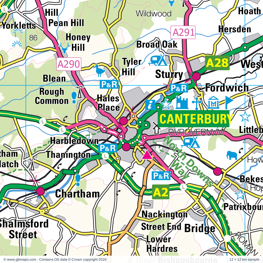
Canterbury regional road map. Full 60 × 60 km PDF, SVG and Illustrator files, with a free PDF sample.

GBMAPS.COM

Canterbury Regional Road Map

Call Us Now for Help01751 473136

GREAT BRITAIN ROAD ATLAS · 1:250,000 GB-600-0150

Canterbury & surrounding area

Explore the full 60 × 60 km Canterbury regional road map at 1:250,000, covering Ashford, Faversham, Sittingbourne, Whitstable, Fordwich. Compare the complete coverage below; a detailed PDF sample is available free.

CANTERBURY & SURROUNDING AREAREGIONAL ROAD MAP
60 × 60 km · Full map previewDownload the free SVG ↓

INSIDE THE FULL 60 × 60 KM MAP

Explore the Canterbury map area

1:250,000 cartography

Towns, villages & places

More mapped places (272)
  • Westwell
  • Molash
  • Leaveland
  • Badlesmere
  • Charing
  • Bilting
  • Throwley
  • Hothfield
  • Shottenden
  • Wye
  • Sheldwich
  • Godmersham
  • Eastling
  • Selling
  • Chilham
  • Crundale
  • Great Chart
  • Brook
  • Pluckley
  • Hinxhill
  • Newnham
  • Whitehill
  • Sole Street
  • Pluckley Thorne
  • Oversland
  • Egerton
  • Doddington
  • Sevington
  • Wichling
  • Lenham
  • Hastingleigh
  • Waltham
  • Egerton Forstal
  • Potter's Forstal
  • Mersham
  • Sandway
  • Kingsnorth
  • Bodsham
  • Chartham
  • Dunkirk
  • Maltman's Hill
  • Bethersden
  • Lynsted
  • Platt's Heath
  • Goodnestone
  • Smeeth
  • Hernhill
  • Elmsted
  • Brabourne
  • Petham
  • Oare
  • Milstead
  • Frinsted
  • Teynham
  • Graveney
  • Harrietsham
  • Aldington Frith
  • Rodmersham
  • Wormshill
  • Dargate
  • Highsted
  • Uplees
  • Sixmile
  • Smarden
  • Harbledown
  • Stowting
  • Bonnington
  • Street End
  • Conyer
  • Aldington
  • Shirkoak
  • Bossingham
  • Ulcombe
  • Upper Hardres
  • Orlestone
  • Tunstall
  • Bredgar
  • Sellindge
  • Nackington
  • Bilsington
  • High Halden
  • Woodchurch
  • Yorkletts
  • Bicknor
  • Blean
  • Kingswood
  • Broomfield
  • Hollingbourne
  • Ruckinge
  • Hamstreet
  • Borden
  • Court-at-Street
  • Standen
  • Warehorne
  • Kenardington
  • Hucking
  • Headcorn
  • Stanford
  • Curteis' Corner
  • Leeds
  • Postling
  • Broad Street
  • Bladbean
  • Lyminge
  • Bridge
  • Elham
  • Newbarn
  • Bobbing
  • Langley Heath
  • Warmlake
  • Biddenden
  • Danaway
  • Bishopsbourne
  • Wingmore
  • Lympne
  • Keycol
  • Newchurch
  • Leigh Green
  • Patrixbourne
  • Etchinghill
  • Stockbury
  • Breach
  • Langley
  • West Hythe
  • Hawkenbury
  • Kingston
  • Broad Oak
  • Bekesbourne
  • Iwade
  • Frittenden
  • Newington
  • Sturry
  • Otham
  • Snave
  • Barham
  • Derringstone
  • Burmarsh
  • Leysdown-on-Sea
  • Thurnham
  • Bearsted
  • Appledore
  • Saltwood
  • Hartlip
  • Eastchurch
  • Snargate
  • Warden
  • Denton
  • Littlebourne
  • Paddlesworth
  • East End
  • Detling
  • Westbere
  • Staplehurst
  • Ivychurch
  • Wootton
  • Densole
  • Brenzett
  • Womenswold
  • Adisham
  • Dymchurch
  • Stone in Oxney
  • Upchurch
  • Ickham
  • Bramling
  • Aylesham
  • Hawkinge
  • Hersden
  • Bredhurst
  • Wickhambreaux
  • Greenhill
  • Sissinghurst
  • St Mary's Bay
  • Herne
  • Rolvenden
  • Brookland
  • Loose
  • Boxley
  • Stodmarsh
  • Snowdown
  • Eddington
  • The Stocks
  • Wittersham
  • Linton
  • Hoath
  • Milebush
  • Marden Thorn
  • Hunters Forstal
  • Maypole
  • Nonington
  • Wingham
  • Wilsley Green
  • Benenden
  • Coxheath
  • Shepherdswell
  • Marden
  • Broomfield
  • Goodnestone
  • Barfrestone
  • Capstone
  • Cranbrook
  • Upstreet
  • Chislet
  • Grove
  • Alkham
  • Iden Green
  • Littlestone-on-Sea
  • Chainhurst
  • Coldred
  • Lydden
  • Shatterling
  • Chillenden
  • Preston
  • Iden
  • Elvington
  • Newenden
  • Winchet Hill
  • Marshside
  • Hunton
  • Staple
  • Blue Bell Hill
  • Greatstone-on-Sea
  • Knowlton
  • Eythorne
  • Aylesford
  • Hartley
  • Hoaden
  • Grain
  • Playden
  • Linkhill
  • Claygate
  • Eccles
  • Rye Foreign
  • Beckley
  • Peasmarsh
  • Sandhurst
  • Reculver
  • Sarre
  • Benover
  • Teston
  • Ash
  • Ditton
  • Westmarsh
  • Ware
  • Four Throws
  • Goudhurst
  • Northiam
  • Stoke
  • Hawkhurst
  • Farthingloe
  • Horsmonden
  • Lower Upnor
  • Mill Corner
  • Wouldham
  • Upper Upnor
  • Allhallows
  • Monkton
  • Allhallows-on-Sea
  • Chattenden
  • Bodiam
  • Halling
  • St Mary Hoo
  • Cuxton
  • Flimwell
  • Staplecross
  • Silver Hill
  • Cooling
  • Salehurst
  • Higham
  • Cripp's Corner
  • Robertsbridge
  • Etchingham
  • Cliffe

Roads across this sheet

M2, M20, A2, A20, A26, A28, A226, A228, A229, A230, A231, A249, A250, A251, A252, A253, A256, A257, A259, A260, A261, A262, A265, A268

More road numbers

A274, A278, A289, A290, A291, A292, A299, A2008, A2009, A2033, A2034, A2042, A2050, A2070, A2100, A2500, A2990, B2000, B2001, B2002, B2004, B2005, B2006, B2007, B2008, B2010, B2011, B2012, B2017, B2040, B2045, B2046, B2063, B2064, B2067, B2068, B2071, B2075, B2079, B2080, B2082, B2084, B2085, B2086, B2087, B2088, B2089, B2090, B2097, B2099, B2108, B2162, B2163, B2165, B2170, B2205, B2229, B2231, B2244, B2246, B2248

Rivers & waterways

East Stour River, Great Stour, Little Stour, Nail Bourne, River Beult, River Brede, River Dudwell, River Len, River Medway, River Rother, River Tillingham, Royal Military Canal

Landmarks & landscape

Acrise Place, Ambley Wood Nature Reserve, Ash Coombe Vineyard, Ashford Borough Museum, Badger's Hill Open Farm, Barton's Point Coastal Park, Battle of Britain Memorial, Battle of Britain Memorial (Hill Figure), Bayford Meadows Kart Circuit, Bearsted Vineyard, Beech Court Gardens, Belmont

More named features

Belmont House and Gardens, Bentif Art Gallery, Biddenden Vineyards, Bodiam Castle, Boughton Monchelsea Place, Boxley Abbey, Brattle Farm Museum, Bredgar and Wormshill Light Railway, Brenzett Aeronautical Museum, Brockhill Country Park, Brockhill Country Park Visitor Centre, Brogdale Farm, C M Booth Collection of Historic Vehicles, Canterbury (World Heritage Site), Canterbury Cathedral, Canterbury Heritage Museum, Roman Museum, The Canterbury Tales Museum, St Augustines Abbey, Westgate Towers, Kent Museum of Freemasonry, Capstone Farm, Capstone Farm Country Park, Visitor Centre, Castle, Cliffe Fort, Conduit House, St Augustine's Abbey, Crabble Corn Mill, Cranbrook Museum, Cranbrook Union Mill, Cromer's Wood Nature Reserve, Dickens World, Diggerland, Doddington Place Gardens, Druidstone Park, Dymchurch Martello Tower No 24, East Blean Wood Nature Reserve, East Cliff and Warren Country Park, East Kent Railway, Elham Valley Railway Museum, Elham Valley Vineyards, Elmley Marshes Nature Reserve, Elmley Nature Reserve, Faversham Pottery, Faversham Stone Chapel, Finchcocks, Flatropers Wood Nature Reserve, Fleur de Lis Heritage Centre, Folkestone Museum, Fort Amherst Heritage Park and Caverns, Go Ape Leeds Castle, Go Ape, Bedgebury Pinetum Visitor Centre, Godinton House, Godinton House Gardens, Goodenstone Gardens, Great Dixter, Great Dixter and Gardens, Green Wicket Animal Sanctuary, Guildhall Museum, Drapers Museum of Bygones, The Old Brook Pumping Museum, Six Poor Travellers House, Watts Charity, HMS Ocelot, HMS Cavalier, HMS Gannett, Historic Dockyard, Ham Street Woods National Nature Reserve, Herne Bay Museum, Herne Windmill, Highlands Farm Rare Breeds Centre, Hole Park Gardens, Hoo Fort, Horne's Place Chapel, Howletts Wild Animal Park, Hythe Local History Room, Iden Croft Herbs, Jungle Jim's, Kent Battle of Britain Museum, Kent Life Farm Attraction, Kent and East Sussex Steam Railway, Kit's Coty House, Kit's Coty House, Little Kit's Coty House, Lamb House, Lashenden Air Warfare Museum, Lathe Barn, Leeds Castle, Lenham Cross, Lenham Cross (Hill Figure), Lenham Solar Park, Leybourne Lakes Country Park, Leysdown Coastal Park, Lower Leas Coastal Park, Luddenham Court, Lydd Town Museum, Lydden Motor Racing Circuit, Lympne Castle, Maidstone Museum, Tyrwhitt-Drake Museum of Carriages, Maison Dieu, Malmaynes Hall Solar Farm, Merriments Gardens, Milton Creek Country Park, Minister Abbey, Minster Abbey, Minster Gatehouse, Molehill Solar Farm, Mote House, Mote Park Miniature Railway, Mount Ephraim, Norman Castle, Northward Hill Nature Reserve, Oad Street Craft Centre, Oare Gunpowder Works, Oare Marshes Nature Reserve, Oare Marshes Nature Reserve Visitor Centre, Oyster Yawl Historic Vessel, Pashley Manor Gardens, Patrixbourne Hop Farm, Peene Quarry, Perry Wood & Selling Wood Nature Reserve, Port Lympne Gardens, Port Lympne Wildlife Park, Queenborough Guildhall Museum, Quex House and Gardens, Ranscombe Farm Country Park, Reculver Country Park, Reculver Visitor Centre, Red Sand Tower, Regvlbivm Roman Fort and Reculver Towers, Riverside Country Park, Visitor Centre, Robertsbridge Aviation Society & Museum, Robus Pottery & Tiles, Rochester Art Gallery, Rochester Castle, Rochester Cathedral, Romney Marsh Craft Gallery, Romney Warren Country Park, Romney Warren Country Park Visitor Centre, Romney,Hythe and Dymchurch Railway, Royal Engineers Museum, Kent Police Museum, Rye Heritage Centre & Town Model, Rye Pottery, Rye Art Gallery, Saltwood Castle, Samphire Hoe Country Park, Sandhurst Vineyards, Sarre Windmill, Sedlescombe Organic Vineyard, Sheerness Heritage Centre, Shepherd Neame Ltd Tours, Chart Gunpowder Mills, Sheppey Solar Park, Sissinghurst Castle, Sissinghurst Castle and Gardens, Smallhythe Place, Solar Farm, South Bank Of Swale Nature Reserve, St John's Commandery, St Mary's Church, St Nicholas Solar Farm, St Radigund's Abbey, Stelling Minnis Windmill, Stocks Mill, Stodmarsh National Nature Reserve, Stoneacre, Sutton Valence Castle, Swanton Mill, Sycamore Farm Solar Farm, Temple Manor, Tenterden Vineyard, Tenterden and District Museum, The Colonel Stephens Railway Museum, Teston Bridge Country Park, The Butterfly Centre, The Foord Almshouses, Restoration House, The Friars, The Gurka Visitor Centre, The Russell Gardens, The Strand Leisure Park, The Swale Nature Reserve, The Toy & Model Museum, Thurnham Castle, Tomar Owl Sanctuary, Tyland Barn Wildlife Conservation Visitor Centre, Tyler Hill Meadow Nature Reserve, Upnor Castle, Village Life Museum, Visitor Centre, Waldershare House, Watts Charity, The Old Brook Pumping Station, West Gate Museum, Greyfriars, Kent Masonic Library & Museum, White Horse Wood Country Park, Whitstable Museum & Art Gallery, Railway Museum, Whitstable Oyster and Fishery Exhibition, Wildwood, Wingham Wildlife Park, Women's Land Army Museum, Woodchurch Windmill, Wye Crown, Wye Crown (Hill Figure), Wye Downs National Nature Reserve, Wye Valley Agricultural Museum
Local authority & parish coverage

Wholly or partly within the full map rectangle. These boundaries are coverage information, not additional artwork layers.

  • Ashford DistrictWholly within
  • Canterbury DistrictWholly within
  • Dover DistrictPartly within
  • Folkestone and Hythe DistrictPartly within
  • Gravesham DistrictPartly within
  • Maidstone DistrictPartly within
  • MedwayPartly within
  • Rother DistrictPartly within
  • Swale DistrictWholly within
  • Thanet DistrictPartly within
  • ThurrockPartly within
  • Tonbridge and Malling DistrictPartly within
  • Tunbridge Wells DistrictPartly within
Wards & electoral divisions 180 areas
  • Abbey Ward
  • Alkham & Capel-le-Ferne Ward
  • All Saints Ward (part)
  • Allington & Bridge Ward
  • Aylesford & East Stour Ward
  • Aylesford North & North Downs Ward
  • Aylesford South & Ditton Ward
  • Aylesham, Eythorne & Shepherdswell Ward
  • Barming Heath & Teston Ward (part)
  • Barton Ward
  • Bearsted & Downswood Ward
  • Beaver Ward
  • Beltinge Ward
  • Biddenden Ward
  • Birchington North Ward (part)
  • Birchington South Ward (part)
  • Bircholt Ward
  • Blean Forest Ward
  • Bobbing, Iwade and Lower Halstow Ward
  • Bockhanger Ward
  • Borden and Grove Park Ward
  • Boughton Monchelsea & Chart Sutton Ward
  • Boughton and Courtenay Ward
  • Boxley Downs Ward
  • Brede & Udimore Ward (part)
  • Broadmead Ward
  • Buckland Ward (part)
  • Burwash & the Weald Ward (part)
  • Bybrook Ward
  • Chalkwell Ward
  • Charing Ward
  • Chartham & Stone Street Ward
  • Chatham Central & Brompton Ward
  • Cheriton Ward
  • Chestfield Ward
  • Conningbrook & Little Burton Farm Ward
  • Coxheath & Farleigh Ward (part)
  • Cranbrook, Sissinghurst & Frittenden Ward
  • Cuxton, Halling & Riverside Ward (part)
  • Dover Downs & River Ward (part)
  • Downs North Ward
  • Downs West Ward
  • East Downs Ward
  • East Folkestone Ward
  • East Malling, West Malling & Offham Ward (part)
  • East Tilbury, Linford & West Tilbury Ward (part)
  • Eastern Rother Ward (part)
  • Eastry Rural Ward (part)
  • Fant & Oakwood Ward
  • Folkestone Central Ward
  • Folkestone Harbour Ward
  • Fort Horsted Ward
  • Fort Pitt Ward
  • Furley Ward
  • Gillingham North Ward
  • Gillingham South Ward
  • Goat Lees Ward
  • Godinton Ward
  • Gorrell Ward
  • Greenhill Ward
  • Grove Green & Vinters Park Ward
  • Harrietsham, Lenham & North Downs Ward
  • Hartlip, Newington and Upchurch Ward
  • Hawkhurst, Sandhurst & Benenden Ward
  • Headcorn & Sutton Valence Ward
  • Hempstead & Wigmore Ward
  • Herne & Broomfield Ward
  • Heron Ward
  • High Street Ward
  • Higham & Shorne Ward (part)
  • Highfield Ward
  • Homewood Ward
  • Hoo St. Werburgh & High Halstow Ward (part)
  • Hurst Green & Ticehurst Ward (part)
  • Hythe Rural Ward
  • Hythe Ward
  • Isle of Oxney Ward
  • Istead Rise, Cobham & Luddesdown Ward (part)
  • Kemsley Ward
  • Kennington Ward
  • Kingsnorth Village & Bridgefield Ward
  • Larkfield Ward (part)
  • Leeds & Langley Ward
  • Little Stour & Adisham Ward
  • Little Stour & Ashstone Ward (part)
  • Loose & Linton Ward
  • Lordswood & Walderslade Ward
  • Luton Ward
  • Marden & Yalding Ward (part)
  • Maxton & Elms Vale Ward (part)
  • Mersham, Sevington South with Finberry Ward
  • Milton Regis Ward
  • Minster Cliffs Ward
  • Murston Ward
  • Nailbourne Ward
  • New Romney Ward
  • Norman Ward
  • North Battle, Netherfield & Whatlington Ward (part)
  • North Downs East Ward
  • North Downs West Ward
  • Northern Rother Ward (part)
  • Northgate Ward
  • Paddock Wood Ward (part)
  • Palace Wood Ward
  • Park Farm North Ward
  • Park Farm South Ward
  • Park Wood & Mangravet Ward
  • Penenden Heath Ward
  • Princes Park Ward
  • Priory Ward
  • Queenborough and Halfway Ward
  • Rainham North Ward
  • Rainham South East Ward
  • Rainham South West Ward
  • Reculver Ward
  • Repton Ward
  • Ringlestone Ward
  • Robertsbridge Ward
  • Rochester East & Warren Wood Ward
  • Rochester West & Borstal Ward
  • Rolvenden & Tenterden West Ward
  • Roman Ward
  • Roman Ward
  • Romney Marsh Ward
  • Rural Tunbridge Wells Ward (part)
  • Rye & Winchelsea Ward (part)
  • Sandgate & West Folkestone Ward
  • Sandwich Ward (part)
  • Saxon Shore Ward
  • Seasalter Ward
  • Sedlescombe & Westfield Ward (part)
  • Senacre Ward
  • Sheerness Ward
  • Sheppey Central Ward
  • Sheppey East Ward
  • Shepway Ward
  • Singleton East Ward
  • Singleton West Ward
  • Snodland East & Ham Hill Ward (part)
  • Snodland West & Holborough Lakes Ward (part)
  • St. Ann's Ward
  • St. Mary's Island Ward
  • St. Radigunds Ward (part)
  • St. Stephens Ward
  • Stanhope Ward
  • Staplehurst Ward
  • Strood North & Frindsbury Ward
  • Strood Rural Ward (part)
  • Strood West Ward
  • Sturry Ward
  • Swalecliffe Ward
  • Tankerton Ward
  • Tenterden North Ward
  • Tenterden South Ward
  • Tenterden St. Michael's Ward
  • Teynham and Lynsted Ward
  • Thanet Villages Ward (part)
  • The Meads Ward
  • Tovil Ward
  • Town & Castle Ward (part)
  • Twydall Ward
  • Upper Weald Ward
  • Victoria Ward
  • Walderslade Ward
  • Walland & Denge Marsh Ward (part)
  • Washford Ward
  • Watling Ward
  • Watling Ward
  • Wayfield & Weeds Wood Ward
  • Weald Central Ward
  • Weald North Ward
  • Weald South Ward
  • West Bay Ward
  • West Downs Ward
  • Westgate Ward
  • Whitfield Ward (part)
  • Willesborough Ward
  • Wincheap Ward
  • Woodstock Ward
  • Wye with Hinxhill Ward
Civil parishes & communities 261 areas
  • Acol CP (part)
  • Acrise CP
  • Adisham CP
  • Aldington CP
  • Alkham CP
  • Allhallows CP (part)
  • Appledore CP
  • Ash CP (part)
  • Aylesford CP
  • Aylesham CP
  • Badlesmere CP
  • Bapchild CP
  • Barham CP
  • Barming CP
  • Battle CP (part)
  • Bearsted CP
  • Beckley CP (part)
  • Bekesbourne-with-Patrixbourne CP
  • Benenden CP
  • Bethersden CP
  • Bicknor CP
  • Biddenden CP
  • Bilsington CP
  • Birchington CP (part)
  • Bishopsbourne CP
  • Blean CP
  • Bobbing CP
  • Bodiam CP
  • Bonnington CP
  • Borden CP
  • Boughton Aluph CP
  • Boughton Malherbe CP
  • Boughton Monchelsea CP
  • Boughton under Blean CP
  • Boxley CP
  • Brabourne CP
  • Brede CP (part)
  • Bredgar CP
  • Bredhurst CP
  • Brenchley and Matfield CP (part)
  • Brenzett CP
  • Bridge CP
  • Brightling CP (part)
  • Brook CP
  • Brookland CP
  • Broomfield and Kingswood CP
  • Burham CP
  • Burmarsh CP
  • Burwash CP (part)
  • Camber CP (part)
  • Capel-le-Ferne CP
  • Challock CP
  • Charing CP
  • Chart Sutton CP
  • Chartham CP
  • Chestfield CP
  • Chilham CP
  • Chislet CP
  • Cliffe and Cliffe Woods CP (part)
  • Cobham CP (part)
  • Collier Street CP (part)
  • Cooling CP
  • Coxheath CP
  • Cranbrook & Sissinghurst CP
  • Crundale CP
  • Cuxton CP (part)
  • Denton with Wootton CP
  • Detling CP
  • Ditton CP
  • Doddington CP
  • Dover CP (part)
  • Downswood CP
  • Dunkirk CP
  • Dymchurch CP
  • East Farleigh CP
  • East Guldeford CP (part)
  • East Malling & Larkfield CP (part)
  • East Sutton CP
  • Eastchurch CP
  • Eastling CP
  • Eastry CP (part)
  • Eastwell CP
  • Egerton CP
  • Elham CP
  • Elmsted CP
  • Etchingham CP (part)
  • Ewhurst CP
  • Eythorne CP
  • Faversham CP
  • Folkestone CP
  • Fordwich CP
  • Frindsbury Extra CP
  • Frinsted CP
  • Frittenden CP
  • Godmersham CP
  • Goodnestone CP
  • Goudhurst CP (part)
  • Graveney with Goodnestone CP
  • Great Chart with Singleton CP
  • Hackington CP
  • Halling CP (part)
  • Harbledown and Rough Common CP
  • Harrietsham CP
  • Hartlip CP
  • Hastingleigh CP
  • Hawkhurst CP
  • Hawkinge CP
  • Headcorn CP
  • Herne and Broomfield CP
  • Hernhill CP
  • Hersden CP
  • High Halden CP
  • High Halstow CP (part)
  • Higham CP (part)
  • Hoath CP
  • Hollingbourne CP
  • Hoo St. Werburgh CP
  • Horsmonden CP (part)
  • Hothfield CP
  • Hougham Without CP
  • Hucking CP
  • Hunton CP
  • Hurst Green CP
  • Hythe CP
  • Ickham and Well CP
  • Iden CP
  • Isle of Grain CP
  • Ivychurch CP (part)
  • Iwade CP
  • Kenardington CP
  • Kennington CP
  • Kingsnorth CP
  • Kingston CP
  • Langley CP
  • Leaveland CP
  • Leeds CP
  • Lenham CP
  • Leysdown CP
  • Linton CP
  • Little Chart CP
  • Littlebourne CP
  • Loose CP
  • Lower Halstow CP
  • Lower Hardres and Nackington CP
  • Luddenham CP
  • Lydd CP (part)
  • Lydden CP
  • Lyminge CP
  • Lympne CP
  • Lynsted with Kingsdown CP
  • Marden CP
  • Mersham CP
  • Milstead CP
  • Minster CP (part)
  • Minster-on-Sea CP
  • Molash CP
  • Monks Horton CP
  • Monkton CP (part)
  • Mountfield CP (part)
  • New Romney CP
  • Newchurch CP
  • Newenden CP
  • Newington CP
  • Newington CP
  • Newnham CP
  • Nonington CP
  • Northiam CP
  • Norton, Buckland and Stone CP
  • Oare CP
  • Old Romney CP
  • Orlestone CP
  • Ospringe CP
  • Otham CP
  • Otterden CP
  • Paddlesworth CP
  • Paddock Wood CP (part)
  • Peasmarsh CP (part)
  • Petham CP
  • Playden CP
  • Pluckley CP
  • Postling CP
  • Preston CP
  • Queenborough CP
  • River CP (part)
  • Rodmersham CP
  • Rolvenden CP
  • Ruckinge CP
  • Rye CP (part)
  • Rye Foreign CP
  • Salehurst and Robertsbridge CP
  • Saltwood CP
  • Sandgate CP
  • Sandhurst CP
  • Sarre CP
  • Sedlescombe CP (part)
  • Sellindge CP
  • Selling CP
  • Sevington with Finberry CP
  • Shadoxhurst CP
  • Sheerness CP
  • Sheldwich CP
  • Shepherdswell with Coldred CP
  • Shorne CP (part)
  • Smarden CP
  • Smeeth CP
  • Snargate CP
  • Snodland CP (part)
  • South Willesborough & Newtown CP
  • St. Mary Hoo CP (part)
  • St. Mary in the Marsh CP
  • St. Nicholas At Wade CP
  • Stalisfield CP
  • Stanford CP
  • Stanhope CP
  • Staple CP
  • Staplehurst CP
  • Stelling Minnis CP
  • Stockbury CP
  • Stoke CP
  • Stone-cum-Ebony CP
  • Stourmouth CP
  • Stowting CP
  • Sturry CP
  • Sutton CP (part)
  • Sutton Valence CP
  • Swingfield CP
  • Temple Ewell CP
  • Tenterden CP
  • Teston CP (part)
  • Teynham CP
  • Thanington CP
  • Throwley CP
  • Thurnham CP
  • Ticehurst CP (part)
  • Tilmanstone CP (part)
  • Tonge CP
  • Tovil CP
  • Tunstall CP
  • Udimore CP (part)
  • Ulcombe CP
  • Upchurch CP
  • Upper Hardres CP
  • Waltham CP
  • Warden CP
  • Warehorne CP
  • West Farleigh CP (part)
  • Westbere CP
  • Westwell CP
  • Whatlington CP (part)
  • Whitfield CP (part)
  • Wichling CP
  • Wickhambreaux CP
  • Wingham CP
  • Wittersham CP
  • Womenswold CP
  • Woodchurch CP
  • Woodnesborough CP (part)
  • Wormshill CP
  • Wouldham CP
  • Wye with Hinxhill CP
  • Yalding CP (part)

Source: the GBMaps road atlas, OS Boundary-Line and postcode mapping datasets. Source editions are being checked for publication. Unmarked boundary names are wholly within the sheet; “part” means the map edge crosses the area.

Place lists are selected from the map source, not a complete gazetteer. Named features describe the cartography; visitor facilities and opening status are not verified. The free sample covers only 12 × 12 km of this larger sheet.

INSIDE YOUR DOWNLOAD

A proper road map, in useful formats

Road classifications, towns and villages, railways, rivers, landscape detail and tourist symbols, brought together in the GBMaps regional road atlas style.

PDF filePDFSVG fileSVGAdobe Illustrator AI fileAi

PDF for the finished map. SVG and layered Illustrator artwork for adapting colours, adding your own information and preparing designs.

THE FINISHED SHEET

Designed for print and presentation

Map coverage
60 × 60 km
Sample coverage
12 × 12 km
Print layout
A3 landscape · enlarged 1:250k cartography
Sheet furniture
Border, scale bar, key & north arrow

A few useful details

What changes when I select another square?

Select a surrounding square to bring it into the centre and reveal the maps around it. Each square is a different 60 × 60 km map. The preview, free sample and selected download change together. Neighbouring sheets overlap by 30 km so you can choose the coverage that suits you.

Is the free sample a vector map?

The on-page detail is an SVG. The free download is a separate 12 × 12 km PDF with a link to the full map. Please retain its copyright credits and product link when sharing it.

Can I buy a larger combined map?

These downloads are individual ready-made sheets. Contact GBMaps if you need a larger combined area.

FREE PDF SAMPLE

Your free map sample

Your free 12 × 12 km sample includes a link back to this map, so you can return for the full area whenever you need it.

Download free PDF sample ↓

Get your Canterbury map

Map download bundle

£24.00including VATOne payment

Pay securely

One payment. Your map stays open.

Your map download

Your map files

Preparing your download…

Checking your private download link…

Your map downloads

Already bought a map?

Find the downloads from your purchases.

Enter the email address you used at checkout. We’ll email you a private link to your available map downloads.