Cambridge regional road map. Full 60 × 60 km PDF, SVG and Illustrator files, with a free PDF sample.

GBMAPS.COM

Cambridge Regional Road Map

Call Us Now for Help01751 473136

GREAT BRITAIN ROAD ATLAS · 1:250,000 GB-540-0240

Cambridge & surrounding area

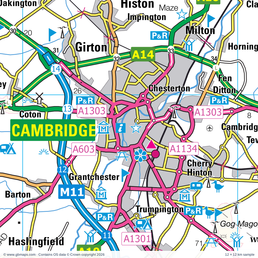
Explore the full 60 × 60 km Cambridge regional road map at 1:250,000, covering Cambridge, Royston, Buntingford, Baldock, Stotfold. Compare the complete coverage below; a detailed PDF sample is available free.

CAMBRIDGE & SURROUNDING AREAREGIONAL ROAD MAP
60 × 60 km · Full map previewDownload the free SVG ↓

INSIDE THE FULL 60 × 60 KM MAP

Explore the Cambridge map area

1:250,000 cartography

Towns, villages & places

More mapped places (306)
  • Newmarket
  • Harpenden
  • Barley
  • Newsells
  • Heydon
  • Chrishall
  • Barkway
  • Melbourn
  • Nuthampstead
  • Reed
  • Elmdon
  • Fowlmere
  • Langley
  • Duddenhoe End
  • Meldreth
  • Therfield
  • Anstey
  • Kneesworth
  • Buckland
  • Thriplow
  • Bassingbourn
  • Kelshall
  • Shepreth
  • Meesden
  • Whaddon
  • Foxton
  • Strethall
  • Wyddial
  • Chipping
  • Litlington
  • Sandon
  • Ford End
  • Barrington
  • Arkesden
  • Mill End
  • Duxford
  • Newton
  • Ickleton
  • Wendy
  • Little Hormead
  • Hinxton
  • Clavering
  • Whittlesford
  • Harston
  • Orwell
  • Wimpole
  • Shingay
  • Littlebury
  • Throcking
  • Little Chesterford
  • Haslingfield
  • Redhill
  • Aspenden
  • Wallington
  • Berden
  • Harlton
  • Arrington
  • Pampisford
  • Croydon
  • Rushden
  • Sawston
  • Hauxton
  • Rickling
  • Ashwell
  • Westmill
  • Cottered
  • Newport
  • Hay Street
  • Great Shelford
  • Stapleford
  • Tadlow
  • Bygrave
  • Hare Street
  • Quendon
  • Braughing
  • Clothall
  • Cromer
  • Babraham
  • Braughing Friars
  • Ardeley
  • Albury
  • Barton
  • Newnham
  • Nasty
  • Grantchester
  • Wrestlingworth
  • Eyeworth
  • Little Abington
  • Ugley
  • Kingston
  • Widdington
  • Manuden
  • Comberton
  • Wood End
  • Caldecote
  • Albury End
  • Hinxworth
  • Toft
  • Sewards End
  • Hadstock
  • Dunton
  • Hildersham
  • Debden
  • Farnham
  • Weston
  • Radwell
  • Longstowe
  • Edworth
  • Standon
  • Haultwick
  • Ugley Green
  • Caldecote
  • Linton
  • Walkern
  • Bourn
  • Astwick
  • Hazel End
  • Henham
  • Ashdon
  • Coton
  • Elsenham
  • Bartlow
  • Dane End
  • Benington
  • Hardwick
  • Hebing End
  • Latchford
  • Wimbish
  • Sutton
  • Fulbourn
  • Aston End
  • Birchanger
  • Gamlingay
  • Whempstead
  • Madingley
  • Barwick
  • Radwinter
  • Graveley
  • Teversham
  • Caxton
  • Waresley
  • Cambourne
  • Arlesey
  • Chickney
  • Langford
  • Balsham
  • Sacombe
  • Aston
  • Green Tye
  • Broxted
  • Henlow
  • Girton
  • Horseheath
  • Wadesmill
  • Everton
  • Broom
  • Ickleford
  • Eltisley
  • Bedlar's Green
  • Hempstead
  • Impington
  • Thundridge
  • Clifton
  • Stanford
  • Bar Hill
  • Tonwell
  • Abbotsley
  • Knapwell
  • Histon
  • Milton
  • Spellbrook
  • Lolworth
  • Holwell
  • Beeston
  • Widford
  • Oakington
  • Horningsea
  • Wareside
  • Stapleford
  • Takeley
  • Knebworth
  • Boxworth
  • Gosmore
  • Croxton
  • Elsworth
  • Charlton
  • Bottisham
  • Westwick
  • Datchworth
  • Southill
  • Hatch
  • Langley
  • Ickwell
  • Northill
  • Hunsdon
  • Thorncote Green
  • Landbeach
  • Meppershall
  • Lode
  • Waterford
  • Longstanton
  • Clayhithe
  • High Wych
  • Pirton
  • Bramfield
  • Preston
  • Yelling
  • Hunsdonbury
  • Tempsford
  • Withersfield
  • Blunham
  • Campton
  • Waterbeach
  • Lindsell
  • Brinkley
  • Conington
  • Oaklands
  • Chicksands
  • Moggerhanger
  • Carlton
  • Great Amwell
  • Toseland
  • Cottenham
  • Shillington
  • Rampton
  • Sheering
  • Gilston
  • Tewin
  • St Margarets
  • Oxen End
  • Eastwick
  • Graveley
  • Codicote
  • Whitwell
  • Hilton
  • Roxton
  • Ley Green
  • Duck End
  • Dullingham
  • Swavesey
  • Welwyn
  • Finchingfield
  • Wyboston
  • Chawston
  • Hertingfordbury
  • Bacon End
  • Little Wratting
  • Great Thurlow
  • Fenstanton
  • Pegsdon
  • Bendish
  • Roydon
  • Sturmer
  • Willington
  • Matching
  • Stebbing
  • Birch Green
  • Little Bradley
  • Hexton
  • Cople
  • Ayot St Peter
  • Cole Green
  • Reach
  • White Roding
  • Lilley
  • Colesden
  • Kimpton
  • Barnston
  • Chittering
  • Duloe
  • Offord D'Arcy
  • Woodditton
  • Cockernhoe
  • Hail Weston
  • Kirtling Green
  • Staploe
  • Southoe
  • Burwell
  • Offord Cluny
  • Diddington
  • Peters Green
  • Cromer Hyde
  • Exning
  • Kirtling
  • Stanborough
  • Saxon Street
  • Felsted
  • North End
  • Buckden
  • Colmworth
  • Cheveley
  • East Hyde
  • New Mill End
  • Landwade
  • Ford End
  • Pleshey
  • Snailwell
  • Ashley
  • Sandridge
  • Mashbury
  • Grafham
  • Moulton
  • Chippenham
  • Stonely
  • Redbourn
  • Kennett

Roads across this sheet

M11, A1(M), A10, A11, A14, A119, A120, A142, A143, A414, A505, A507, A600, A602, A603, A604, A1000, A1001, A1017, A1019, A1059, A1060, A1070, A1072

More road numbers

A1081, A1096, A1134, A1155, A1169, A1170, A1184, A1198, A1250, A1301, A1303, A1304, A1307, A1309, A4280, A5183, A5228, A6001, A6129, B158, B180, B181, B183, B184, B195, B197, B487, B645, B651, B652, B653, B655, B656, B658, B659, B660, B661, B1000, B1004, B1008, B1037, B1038, B1039, B1040, B1041, B1042, B1043, B1046, B1047, B1048, B1049, B1050, B1051, B1052, B1053, B1054, B1055, B1057, B1058, B1061, B1063, B1085, B1102, B1103, B1197, B1256, B1351, B1368, B1383, B1417, B1428, B1502, B1506, B1514, B1529

Rivers & waterways

New River, Pods Brook, River Ash, River Beane, River Cam, River Cam or Granta, River Cam or Rhee, River Can, River Chelmer, River Colne, River Flit, River Granta

More waterways

River Great Ouse, River Hiz, River Ivel, River Ivel Navigation, River Kennett, River Kym, River Lea or Lee, River Lee Navigation, River Pant, River Quin, River Rib, River Stort, River Stour, River Ter, River Ver

Landmarks & landscape

Abington Pottery, Anglesey Abbey, Anglesey Abbey and Gardens, Ashdon Village Museum, Ashwell Gallery, Ashwell Village Museum, Audley End, Audley End Miniature Railway, Aythorpe Roding Postmill, Bassingbourn Solar Farm, Bedford Microflight Centre, Benington Lordship Garden

More named features

Black Peak Solar Farm, Bourn Windmill, Bridge End Gardens and Maze, Buckden Palace (remains of), Burwell Solar Farm, Bury Lane Solar Farm, Bushmead Priory, Cambridge Corn Exchange, Kids Kingdom and Laser Quest, Cambridge Contemporary Art, Cambridge University Botanic Gardens, Cambridge and County Folk Museum, Museums of Classical Archaeology, Zoology and Science, Scott Polar Institute, Aerial Photography, Archaeology and Anthropology, Castle, Chells Park, Chilford Hall Vineyard, Cottenham Point to Point Racecourse, Cromer Windmill, Croydon Solar Farm, Denny Abbey, Devil's Dyke Nature Reserve, Devils Dyke (Ditch Farm) Nature Reserve, Docwra's Manor Garden, Dovecote, Duxford Chapel, Duxford Imperial War Museum, East Town Park Country Park & Visitor Centre, Fairlands Valley Park, Farmland Museum, Finchingfield Guildhall, Finchingfield Postmill, Fitzwilliam Museum, Sedgewick Museum Of Earth Sciences, Whipple Museum of the History of Science, Fleam Dyke Nature Reserve, Fordham Abbey, Fowlmere Nature Reserve, Fox Covert Nature Reserve, Gibbard Garden, Gilston Park, Glendale Forge, Grafham Water Nature Reserve, Grafham Water Visitor Centre, Grafham Water Wildlife Cabin, Great Bardfield Cage, Great Bardfield Cottage Museum, Great Gransden Mill, Hatfield Forest Country Park, Henry Moore Foundation, Hertford Castle, Hertford Museum, Hill Farm Solar Farm, Hinxton Watermill, Hitchin British Schools, Hitchin Museum, Hoback Farm Solar Farm, Horseheath Point to Point Racecourse, House on the Hill Toy Museum, Jordans Mill, Kartsport (Caxton), Knebworth Country Park, Knebworth House, L Moor Nature Reserve, Langley Park Rally School, Lark Hall, Letchworth Museum & Art Gallery, First Garden City Heritage Museum, Limekiln Close Nature Reserve, Linton Zoological Gardens, Lode Mill, Luton Hoo, Mark Hall Cycle Museum & Gardens, Maze, Mill Green Watermill and Museum, Milton Country Park, Moggerhanger Park, Moulton Packhorse Bridge, Mountfitchet Castle, Mountfitchet Castle and Norman Village, Munceys Solar Farm, Museum, Museum of Technology, Museum of Archaeology, Museum of Archaeology & Anthropology, Science Centre, National Horse Racing Museum, National Stud, Newmarket Racecourses, Parndon Mill, Patmore Heath Nature Reserve, Paxton Pits Nature Reserve, Paxton Pits Visitor Centre, Prior's Hall Barn, Radio Astronomy Observatory, Redbourn Village Museum, Redbournbury Mill, Royston & District Museum, Rupert Brooke Museum, Rye House Marsh Nature Reserve, Saffron Walden Arts Centre, Saffron Walden Museum, Saling Hall Gardens, Sascombe Vineyard, Scott's Grotto, Shaw's Corner, Shepreth Wildlife Park, Solar Farm, Someries Castle, St Neots Museum, Standalone Farm Centre, Stevenage Museum, Stondon Transport Museum, Stotfold Mill, Swiss Garden, Thaxted Windmill, The Gardens of Easton Lodge, The John MacDougal Visitor Centre, The Lodge Nature Reserve, The Maltings, The Rhodes Centre, The Shuttleworth Collection, Therfield Heath Nature Reserve, Trumpington Meadows Country Park, Tumuli, Turf Maze, Walden Castle, Wandlebury Country Park, Ware Museum, Waterbeach Station Museum, Waterhall Farm, Waterloo Solar Park, Waytemore Castle Gardens, Welwyn Roman Baths, Wildtracks, Willington Dovecote, Wimpole Hall, Wimpole Hall, Wimpole Hall Farm, Wood Green Animal Shelter, Wort's Causeway Nature Reserve, Wyboston Leisure Park
Local authority & parish coverage

Wholly or partly within the full map rectangle. These boundaries are coverage information, not additional artwork layers.

  • BedfordPartly within
  • Braintree DistrictPartly within
  • Broxbourne DistrictPartly within
  • Cambridge DistrictWholly within
  • Central BedfordshirePartly within
  • Chelmsford DistrictPartly within
  • East Cambridgeshire DistrictPartly within
  • East Hertfordshire DistrictPartly within
  • Epping Forest DistrictPartly within
  • Harlow DistrictPartly within
  • Huntingdonshire DistrictPartly within
  • LutonPartly within
  • North Hertfordshire DistrictPartly within
  • South Cambridgeshire DistrictPartly within
  • St. Albans DistrictPartly within
  • Stevenage DistrictWholly within
  • Uttlesford DistrictPartly within
  • Welwyn Hatfield DistrictPartly within
  • West Suffolk DistrictPartly within
Wards & electoral divisions 222 areas
  • Abbey Ward
  • Alconbury Ward (part)
  • Almond Hill Ward
  • Ampthill Ward (part)
  • Arbury Ward
  • Arbury Ward
  • Arlesey & Fairfield Ward
  • Ashdon Ward
  • Aston, Datchworth & Walkern Ward
  • Baldock East Ward
  • Baldock West Ward
  • Balsham Ward
  • Bandley Hill & Poplars Ward
  • Bar Hill Ward
  • Barrington Ward
  • Barton-le-Clay & Silsoe Ward (part)
  • Bassingbourn Ward
  • Bedwell Ward
  • Bernards Heath Ward (part)
  • Biggleswade East Ward
  • Biggleswade West Ward
  • Bishop's Stortford All Saints Ward
  • Bishop's Stortford Central Ward
  • Bishop's Stortford North Ward
  • Bishop's Stortford Parsonage Ward
  • Bishop's Stortford South Ward
  • Bishop's Stortford Thorley Manor Ward
  • Boreham and The Leighs Ward (part)
  • Bottisham Ward
  • Brampton Ward (part)
  • Braughing & Standon Ward
  • Broad Oak & the Hallingburys Ward
  • Brookmans Park & Little Heath Ward (part)
  • Broomfield and The Walthams Ward (part)
  • Buckden Ward
  • Bumpstead Ward (part)
  • Buntingford Ward
  • Burwell Ward (part)
  • Caddington Ward (part)
  • Cadwell Ward
  • Caldecote Ward
  • Cambourne Ward
  • Castle Ward
  • Caxton & Papworth Ward
  • Chells Ward
  • Chelmsford Rural West Ward (part)
  • Cherry Hinton Ward
  • Church Langley North & Newhall Ward (part)
  • Clare, Hundon & Kedington Ward (part)
  • Clavering Ward
  • Clifton, Henlow & Langford Ward
  • Codicote & Kimpton Ward
  • Coleridge Ward
  • Cottenham Ward (part)
  • Debden & Wimbish Ward
  • Duxford Ward
  • East Chesterton Ward
  • Elsenham & Henham Ward
  • Ermine Ward
  • Exning Ward
  • Felsted & Stebbing Ward (part)
  • Fen Ditton & Fulbourn Ward
  • Fenstanton Ward (part)
  • Flitch Green & Little Dunmow Ward
  • Fordham & Isleham Ward (part)
  • Foxton Ward
  • Gamlingay Ward
  • Girton Ward
  • Godmanchester & Hemingford Abbots Ward (part)
  • Graveley, St. Ippolyts & Wymondley Ward
  • Great Amwell & Stansteads Ward (part)
  • Great Ashby Ward
  • Great Barford Ward (part)
  • Great Dunmow North Ward
  • Great Dunmow South & Barnston Ward
  • Great Parndon Ward (part)
  • Great Paxton Ward
  • Great Staughton Ward (part)
  • Haldens Ward
  • Handside Ward
  • Hardwick Ward
  • Harpenden East Ward
  • Harpenden North & Rural Ward (part)
  • Harpenden South Ward
  • Harpenden West Ward
  • Harston & Comberton Ward
  • Hatfield Central Ward (part)
  • Hatfield East Ward (part)
  • Hatfield Heath Ward
  • Hatfield Villages Ward (part)
  • Haverhill Central Ward
  • Haverhill East Ward
  • Haverhill North Ward
  • Haverhill South East Ward
  • Haverhill South Ward
  • Haverhill West Ward
  • Hemingford Grey & Houghton Ward (part)
  • Hertford Bengeo Ward
  • Hertford Castle Ward
  • Hertford Heath & Brickendon Ward (part)
  • Hertford Kingsmead Ward
  • Hertford Rural Ward (part)
  • Hertford Sele Ward
  • High Easter & the Rodings Ward
  • High Town Ward (part)
  • Histon & Impington Ward
  • Hitchin Bearton Ward
  • Hitchin Highbury Ward
  • Hitchin Oughton Ward
  • Hitchin Priory Ward
  • Hitchin Walsworth Ward
  • Hitchwood Ward
  • Hoddesdon North Ward (part)
  • Hoddesdon Town and Rye Park Ward (part)
  • Hollybush Ward
  • Houghton Conquest & Haynes Ward (part)
  • Howlands Ward
  • Hunsdon Ward
  • Iceni Ward (part)
  • Kentford & Moulton Ward (part)
  • Kimbolton Ward (part)
  • King's Hedges Ward
  • Knebworth Ward
  • Letchworth Grange Ward
  • Letchworth Norton Ward
  • Letchworth South East Ward
  • Letchworth South West Ward
  • Letchworth Wilbury Ward
  • Linton Ward
  • Little Hadham & The Pelhams Ward
  • Little Parndon & Town Centre Ward (part)
  • Littlebury, Chesterford & Wenden Lofts Ward
  • Longmeadow Ward
  • Longstanton Ward
  • Manor Ward
  • Mark Hall Ward (part)
  • Market Ward
  • Martins Wood Ward
  • Melbourn Ward
  • Meppershall & Shillington Ward (part)
  • Milton & Waterbeach Ward (part)
  • Much Hadham Ward
  • Netteswell Ward (part)
  • Newmarket East Ward
  • Newmarket North Ward
  • Newmarket West Ward
  • Newnham Ward
  • Newport Ward
  • Northill Ward
  • Offa Ward (part)
  • Old Harlow Ward
  • Old Town Ward
  • Over & Willingham Ward (part)
  • Panshanger Ward
  • Passmores Ward (part)
  • Peartree Ward
  • Petersfield Ward
  • Potton Ward
  • Queen Edith's Ward
  • Rayne Ward (part)
  • Redbourn Ward (part)
  • Renhold & Ravensden Ward (part)
  • Roebuck Ward
  • Romsey Ward
  • Round Green Ward (part)
  • Roydon & Lower Nazeing Ward (part)
  • Royston Heath Ward
  • Royston Meridian Ward
  • Royston Palace Ward
  • Rural East Ward (part)
  • Saffron Walden Audley Ward
  • Saffron Walden Castle Ward
  • Saffron Walden Shire Ward
  • Sandridge & Wheathampstead Ward (part)
  • Sandy Ward
  • Sawbridgeworth Ward
  • Sawston Ward
  • Shefford Ward (part)
  • Shelford Ward
  • Shephall Ward
  • Sherrards Ward
  • Shortstown Ward (part)
  • Soham South Ward (part)
  • South Ward (part)
  • St. Ives South Ward (part)
  • St. Neots East Ward
  • St. Neots Eatons Ward
  • St. Neots Eynesbury Ward
  • St. Neots Priory Park & Little Paxton Ward
  • St. Nicholas Ward
  • Stansted North Ward
  • Stansted South & Birchanger Ward
  • Stopsley Ward (part)
  • Stort Valley Ward
  • Stotfold Ward
  • Swavesey Ward (part)
  • Symonds Green Ward
  • Takeley Ward
  • Thaxted & the Eastons Ward
  • The Mordens Ward
  • The Mundens Ward
  • The Sampfords Ward
  • Three Fields Ward (part)
  • Toddington Ward (part)
  • Trumpington Ward
  • Vauxhall Ward (part)
  • Ware Priory Ward
  • Ware Rural Ward
  • Ware St. Mary's Ward
  • Ware Trinity Ward
  • Watton-at-Stone Ward
  • Welwyn East Ward
  • Welwyn West Ward
  • West Chesterton Ward
  • Weston & Sandon Ward
  • Whittlesford Ward
  • Wigmore Ward
  • Withersfield Ward (part)
  • Woodditton Ward (part)
  • Woodfield Ward
  • Wyboston Ward (part)
  • Yeldham Ward (part)
Civil parishes & communities 398 areas
  • Abbess Beauchamp and Berners Roding CP (part)
  • Abbotsley CP
  • Abington Pigotts CP
  • Albury CP
  • Anstey CP
  • Ardeley CP
  • Arkesden CP
  • Arlesey CP
  • Arrington CP
  • Ashdon CP
  • Ashley CP (part)
  • Ashwell CP
  • Aspenden CP
  • Aston CP
  • Astwick CP
  • Ayot St. Lawrence CP
  • Ayot St. Peter CP
  • Aythorpe Roding CP
  • Babraham CP
  • Balsham CP
  • Bar Hill CP
  • Barkway CP
  • Barley CP
  • Barnardiston CP (part)
  • Barnston CP
  • Barrington CP
  • Bartlow CP
  • Barton CP
  • Barton-le-Clay CP (part)
  • Bassingbourn cum Kneesworth CP
  • Bayford CP (part)
  • Bengeo Rural CP
  • Benington CP
  • Berden CP
  • Biggleswade CP
  • Birchanger CP
  • Birdbrook CP (part)
  • Bishop's Stortford CP
  • Blunham CP
  • Bolnhurst and Keysoe CP (part)
  • Bottisham CP
  • Bourn CP
  • Boxworth CP
  • Bramfield CP
  • Brampton CP (part)
  • Braughing CP
  • Brent Pelham CP
  • Brickendon Liberty CP (part)
  • Brinkley CP
  • Broomfield CP (part)
  • Broxted CP
  • Buckden CP
  • Buckland and Chipping CP
  • Buntingford CP
  • Burrough Green CP
  • Burwell CP (part)
  • Bygrave CP
  • Caldecote CP
  • Caldecote CP
  • Cambourne CP
  • Campton and Chicksands CP (part)
  • Cardington CP (part)
  • Carlton CP
  • Castle Camps CP
  • Caxton CP
  • Cheveley CP
  • Chickney CP
  • Chignall CP (part)
  • Childerley CP
  • Chippenham CP (part)
  • Chrishall CP
  • Clavering CP
  • Clifton CP
  • Clophill CP (part)
  • Clothall CP
  • Codicote CP
  • Colmworth CP (part)
  • Comberton CP
  • Conington CP
  • Cople CP (part)
  • Coton CP
  • Cottenham CP (part)
  • Cottered CP
  • Cotton End CP (part)
  • Cowlinge CP (part)
  • Croxton CP
  • Croydon CP
  • Datchworth CP
  • Debden CP
  • Diddington CP
  • Dry Drayton CP
  • Dullingham CP
  • Dunton CP
  • Duxford CP
  • Easton CP (part)
  • Eastwick CP
  • Edworth CP
  • Ellington CP (part)
  • Elmdon CP
  • Elsenham CP
  • Elsworth CP
  • Eltisley CP
  • Essendon CP (part)
  • Everton CP
  • Exning CP
  • Eyeworth CP
  • Fairfield CP
  • Farnham CP
  • Felsted CP (part)
  • Fen Ditton CP
  • Fen Drayton CP (part)
  • Fenstanton CP (part)
  • Finchingfield CP (part)
  • Flitch Green CP
  • Fordham CP (part)
  • Fowlmere CP
  • Foxton CP
  • Fulbourn CP
  • Furneux Pelham CP
  • Gamlingay CP
  • Gilston CP
  • Girton CP
  • Godmanchester CP (part)
  • Good Easter CP
  • Grafham CP
  • Grantchester CP
  • Graveley CP
  • Graveley CP
  • Gravenhurst CP (part)
  • Great Abington CP
  • Great Amwell CP
  • Great Ashby CP
  • Great Bardfield CP (part)
  • Great Barford CP (part)
  • Great Bradley CP
  • Great Canfield CP
  • Great Chesterford CP
  • Great Dunmow CP
  • Great Easton CP
  • Great Eversden CP
  • Great Gransden CP
  • Great Hallingbury CP
  • Great Munden CP
  • Great Paxton CP
  • Great Sampford CP
  • Great Shelford CP
  • Great Staughton CP
  • Great Thurlow CP (part)
  • Great Waltham CP (part)
  • Great Wilbraham CP
  • Great Wratting CP (part)
  • Great and Little Chishill CP
  • Great and Little Leighs CP (part)
  • Guilden Morden CP
  • Hadstock CP
  • Hail Weston CP
  • Hardwick CP
  • Harlton CP
  • Harpenden Rural CP (part)
  • Harpenden Town CP
  • Harston CP
  • Haslingfield CP
  • Hatfield Broad Oak CP
  • Hatfield CP (part)
  • Hatfield Heath CP
  • Hatley CP
  • Hauxton CP
  • Haverhill CP
  • Haynes CP (part)
  • Helions Bumpstead CP
  • Hemingford Abbots CP (part)
  • Hemingford Grey CP (part)
  • Hempstead CP
  • Henham CP
  • Henlow CP
  • Herringswell CP (part)
  • Hertford CP
  • Hertford Heath CP (part)
  • Hertingfordbury CP (part)
  • Hexton CP (part)
  • Heydon CP
  • High Easter CP
  • High Laver CP (part)
  • High Roding CP
  • High Wych CP
  • Hildersham CP
  • Hilton CP
  • Hinxton CP
  • Hinxworth CP
  • Histon CP
  • Holwell CP
  • Hormead CP
  • Horningsea CP
  • Horseheath CP
  • Hunsdon CP
  • Hyde CP (part)
  • Ickleford CP
  • Ickleton CP
  • Impington CP
  • Kedington CP (part)
  • Kelshall CP
  • Kennett CP (part)
  • Kentford CP (part)
  • Kimbolton CP (part)
  • Kimpton CP
  • King's Walden CP
  • Kingston CP
  • Kirtling CP (part)
  • Knapwell CP
  • Knebworth CP
  • Landbeach CP
  • Langford CP
  • Langley CP
  • Langley CP
  • Leaden Roding CP
  • Lilley CP (part)
  • Lindsell CP
  • Linton CP
  • Litlington CP
  • Little Abington CP
  • Little Bardfield CP
  • Little Barford CP
  • Little Berkhamsted CP (part)
  • Little Bradley CP (part)
  • Little Canfield CP
  • Little Chesterford CP
  • Little Dunmow CP
  • Little Easton CP
  • Little Eversden CP
  • Little Gransden CP
  • Little Hadham CP
  • Little Hallingbury CP
  • Little Laver CP (part)
  • Little Munden CP
  • Little Paxton CP
  • Little Sampford CP
  • Little Shelford CP
  • Little Staughton CP (part)
  • Little Thurlow CP (part)
  • Little Waltham CP (part)
  • Little Wilbraham CP
  • Little Wratting CP (part)
  • Littlebury CP
  • Lode CP
  • Lolworth CP
  • Longstanton CP
  • Longstowe CP
  • Madingley CP
  • Manuden CP
  • Margaret Roding CP
  • Mashbury CP
  • Matching CP (part)
  • Meesden CP
  • Melbourn CP
  • Meldreth CP
  • Meppershall CP
  • Milton CP (DET)
  • Moggerhanger CP
  • Moulton CP (part)
  • Much Hadham CP
  • Newmarket CP
  • Newnham CP
  • Newport CP
  • Newton CP
  • Northill CP
  • Northstowe CP
  • Nuthampstead CP
  • Oakington and Westwick CP
  • Offley CP
  • Offord Cluny and Offord D'Arcy CP
  • Old Warden CP
  • Orchard Park CP
  • Orwell CP
  • Over CP (part)
  • Pampisford CP
  • Papworth Everard CP
  • Papworth St. Agnes CP
  • Perry CP
  • Pertenhall CP (part)
  • Pirton CP
  • Pleshey CP
  • Potton CP
  • Preston CP
  • Quendon and Rickling CP
  • Radwell CP
  • Radwinter CP
  • Rampton CP (part)
  • Rayne CP (part)
  • Reach CP
  • Red Lodge CP (part)
  • Redbourn CP (part)
  • Reed CP
  • Renhold CP (part)
  • Roxton CP
  • Roxwell CP (part)
  • Roydon CP (part)
  • Royston CP
  • Rushden CP
  • Sacombe CP
  • Saffron Walden CP
  • Sandon CP
  • Sandridge CP (part)
  • Sandy CP
  • Sawbridgeworth CP
  • Sawston CP
  • Sewards End CP
  • Sheering CP
  • Shefford CP
  • Shepreth CP
  • Shillington CP (part)
  • Shingay cum Wendy CP
  • Shudy Camps CP
  • Snailwell CP
  • South Trumpington CP
  • Southill CP
  • Southoe and Midloe CP
  • Spaldwick CP (part)
  • St. Ippolyts CP
  • St. Ives CP (part)
  • St. Michael CP (part)
  • St. Neots CP
  • St. Paul's Walden CP
  • Stambourne CP (part)
  • Standon CP
  • Stanstead Abbots CP (part)
  • Stanstead St. Margarets CP
  • Stansted Mountfitchet CP
  • Stapleford CP
  • Stapleford and Waterford CP
  • Staploe CP
  • Stebbing CP (part)
  • Steeple Bumpstead CP (part)
  • Steeple Morden CP
  • Stetchworth CP
  • Stocking Pelham CP
  • Stondon CP
  • Stotfold CP
  • Stow Longa CP (part)
  • Stow cum Quy CP
  • Streatley CP (part)
  • Strethall CP
  • Sturmer CP (part)
  • Sutton CP
  • Swaffham Bulbeck CP
  • Swaffham Prior CP
  • Swavesey CP (part)
  • Tadlow CP
  • Takeley CP
  • Tempsford CP
  • Teversham CP
  • Tewin CP
  • Thaxted CP
  • The Salings CP (part)
  • Therfield CP
  • Thorley CP
  • Thriplow and Heathfield CP
  • Thundridge CP
  • Tilty CP
  • Toft CP
  • Toseland CP
  • Ugley CP
  • Walkern CP
  • Wallington CP
  • Ware CP
  • Wareside CP
  • Waresley-cum-Tetworth CP
  • Waterbeach CP (part)
  • Watton-at-Stone CP
  • Welwyn CP
  • Wenden Lofts CP
  • Wendens Ambo CP
  • West Wickham CP
  • West Wratting CP
  • Westley Waterless CP
  • Westmill CP
  • Weston CP
  • Weston Colville CP
  • Whaddon CP
  • Wheathampstead CP
  • White Roding CP
  • Whittlesford CP
  • Wicken Bonhunt CP
  • Wicken CP (part)
  • Widdington CP
  • Widford CP
  • Wilden CP (part)
  • Willingham CP (part)
  • Willington CP (part)
  • Wimbish CP
  • Wimpole CP
  • Withersfield CP
  • Woodditton CP
  • Woolmer Green CP
  • Wrestlingworth and Cockayne Hatley CP
  • Wyboston, Chawston and Colesden CP
  • Wyddial CP
  • Wymondley CP
  • Yelling CP

Source: the GBMaps road atlas, OS Boundary-Line and postcode mapping datasets. Source editions are being checked for publication. Unmarked boundary names are wholly within the sheet; “part” means the map edge crosses the area.

Place lists are selected from the map source, not a complete gazetteer. Named features describe the cartography; visitor facilities and opening status are not verified. The free sample covers only 12 × 12 km of this larger sheet.

INSIDE YOUR DOWNLOAD

A proper road map, in useful formats

Road classifications, towns and villages, railways, rivers, landscape detail and tourist symbols, brought together in the GBMaps regional road atlas style.

PDF filePDFSVG fileSVGAdobe Illustrator AI fileAi

PDF for the finished map. SVG and layered Illustrator artwork for adapting colours, adding your own information and preparing designs.

THE FINISHED SHEET

Designed for print and presentation

Map coverage
60 × 60 km
Sample coverage
12 × 12 km
Print layout
A3 landscape · enlarged 1:250k cartography
Sheet furniture
Border, scale bar, key & north arrow

A few useful details

What changes when I select another square?

Select a surrounding square to bring it into the centre and reveal the maps around it. Each square is a different 60 × 60 km map. The preview, free sample and selected download change together. Neighbouring sheets overlap by 30 km so you can choose the coverage that suits you.

Is the free sample a vector map?

The on-page detail is an SVG. The free download is a separate 12 × 12 km PDF with a link to the full map. Please retain its copyright credits and product link when sharing it.

Can I buy a larger combined map?

These downloads are individual ready-made sheets. Contact GBMaps if you need a larger combined area.

FREE PDF SAMPLE

Your free map sample

Your free 12 × 12 km sample includes a link back to this map, so you can return for the full area whenever you need it.

Download free PDF sample ↓

Get your Cambridge map

Map download bundle

£24.00including VATOne payment

Pay securely

One payment. Your map stays open.

Your map download

Your map files

Preparing your download…

Checking your private download link…

Your map downloads

Already bought a map?

Find the downloads from your purchases.

Enter the email address you used at checkout. We’ll email you a private link to your available map downloads.