Cambridge regional road map. Full 60 × 60 km PDF, SVG and Illustrator files, with a free PDF sample.

GBMAPS.COM

Cambridge Regional Road Map

Call Us Now for Help01751 473136

GREAT BRITAIN ROAD ATLAS · 1:250,000 GB-540-0270

Cambridge & surrounding area

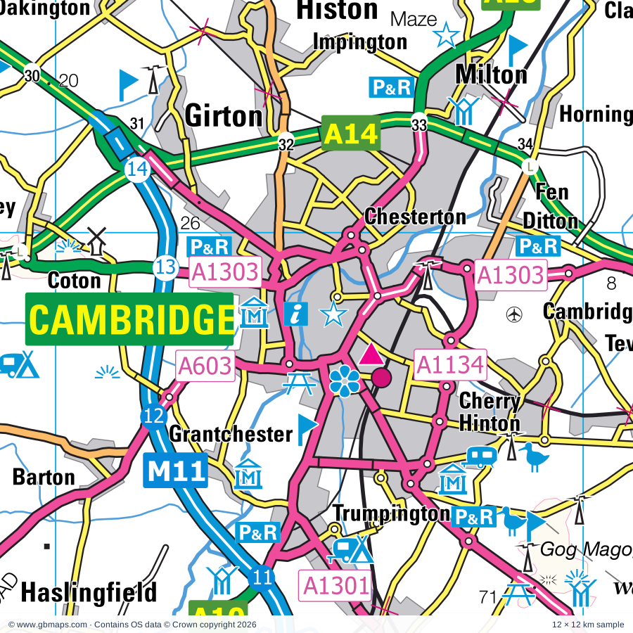
Explore the full 60 × 60 km Cambridge regional road map at 1:250,000, covering Cambridge, Ely, St Ives, Godmanchester, Huntingdon. Compare the complete coverage below; a detailed PDF sample is available free.

CAMBRIDGE & SURROUNDING AREAREGIONAL ROAD MAP
60 × 60 km · Full map previewDownload the free SVG ↓

INSIDE THE FULL 60 × 60 KM MAP

Explore the Cambridge map area

1:250,000 cartography

Towns, villages & places

More mapped places (241)
  • Rampton
  • Longstanton
  • Swavesey
  • Earith
  • Westwick
  • Oakington
  • Cottenham
  • Aldreth
  • Bluntisham
  • Holywell
  • Needingworth
  • Colne
  • Bar Hill
  • Lolworth
  • Histon
  • Boxworth
  • Girton
  • Impington
  • Haddenham
  • Conington
  • Fenstanton
  • Somersham
  • Landbeach
  • Madingley
  • Knapwell
  • Wilburton
  • Sutton
  • Chittering
  • Pidley
  • Woodhurst
  • Elsworth
  • Milton
  • Waterbeach
  • Hardwick
  • Coton
  • Mepal
  • Hilton
  • Clayhithe
  • Wentworth
  • Witcham
  • Horningsea
  • Houghton
  • Stretham
  • Old Hurst
  • Fenton
  • Cambourne
  • Witchford
  • Warboys
  • Upware
  • Caldecote
  • Comberton
  • Barton
  • Broughton
  • Toft
  • Grantchester
  • Coveney
  • Caxton
  • Teversham
  • Lode
  • Bourn
  • Barway
  • Kingston
  • Yelling
  • Graveley
  • Wistow
  • Eltisley
  • Reach
  • Bottisham
  • Wicken
  • Horseway
  • Longstowe
  • Stuntney
  • Harlton
  • Toseland
  • Haslingfield
  • Bury
  • Fulbourn
  • Offord Cluny
  • Hauxton
  • Offord D'Arcy
  • Little Downham
  • Croxton
  • Great Shelford
  • Wennington
  • Brampton
  • Upwood
  • Pymoor
  • Burwell
  • Stapleford
  • Harston
  • Orwell
  • Chettisham
  • Broad Hill
  • Barrington
  • Doddington
  • Wimpole
  • Manea
  • Newton
  • Buckden
  • Benwick
  • Arrington
  • Diddington
  • Woodwalton
  • Waresley
  • Foxton
  • Abbotsley
  • Shepreth
  • Croydon
  • Exning
  • Wimblington
  • Alconbury
  • Sawston
  • Southoe
  • Landwade
  • Babraham
  • Prickwillow
  • Whittlesford
  • Fordham
  • Wendy
  • Meldreth
  • Littleport
  • Thriplow
  • Pampisford
  • Grafham
  • Gamlingay
  • Upton
  • Ellington
  • Fowlmere
  • Whaddon
  • Little Abington
  • Snailwell
  • Isleham
  • Hail Weston
  • Shingay
  • Duxford
  • Woolley
  • Melbourn
  • Coppingford
  • Tadlow
  • Hildersham
  • Duloe
  • Dullingham
  • Buckworth
  • Easton
  • Pondersbridge
  • Chippenham
  • Kneesworth
  • Hinxton
  • Wrestlingworth
  • Balsham
  • Freckenham
  • Staploe
  • Barham
  • Bassingbourn
  • Sawtry
  • Welney
  • Spaldwick
  • Wyboston
  • Conington
  • Everton
  • Turves
  • Brinkley
  • Holme
  • Ickleton
  • Christchurch
  • Woodditton
  • Tempsford
  • Hamerton
  • Chawston
  • Eyeworth
  • Linton
  • Kenny Hill
  • Litlington
  • Lakes End
  • Westry
  • Sutton
  • Roxton
  • Eastrea
  • Coates
  • Stonely
  • Worlington
  • Glatton
  • Little Gidding
  • Saxon Street
  • Carlton
  • Cheveley
  • Eldernell
  • Hadstock
  • Kennett
  • Moulton
  • Heydon
  • Beck Row
  • Dunton
  • Little Chesterford
  • Colesden
  • Stilton
  • Denton
  • Bartlow
  • Ashley
  • Blunham
  • Colmworth
  • Yaxley
  • Horseheath
  • Winwick
  • Caldecote
  • Farcet
  • Kirtling Green
  • Kirtling
  • Beeston
  • North Side
  • Folksworth
  • Hatch
  • Moggerhanger
  • Southery
  • Little Bradley
  • Thorncote Green
  • Ashdon
  • Morborne
  • Withersfield
  • Hinxworth
  • Ten Mile Bank
  • Lutton
  • Edworth
  • Great Thurlow
  • Northill
  • Haddon
  • Ickwell
  • Willington
  • Broom
  • Hilgay
  • Langford
  • Cople
  • Little Wratting
  • Fordham
  • Chesterton
  • Stanford
  • Southill
  • Sturmer
  • Castor
  • Ailsworth
  • Wretton

Roads across this sheet

M11, A1(M), A10, A11, A14, A14(M), A15, A141, A142, A143, A505, A600, A603, A604, A605, A1017, A1096, A1101, A1123, A1134, A1139, A1179, A1198, A1260

More road numbers

A1301, A1303, A1304, A1307, A1309, A1421, A4280, A6001, B184, B645, B658, B659, B660, B661, B1039, B1040, B1041, B1042, B1043, B1044, B1046, B1047, B1048, B1049, B1050, B1052, B1054, B1057, B1058, B1061, B1063, B1085, B1086, B1089, B1090, B1091, B1092, B1093, B1094, B1095, B1096, B1098, B1099, B1100, B1101, B1102, B1103, B1104, B1160, B1368, B1381, B1382, B1383, B1386, B1411, B1428, B1506, B1514

Rivers & waterways

Canal, Counter Drain, Forty Foot or Vermuden's Drain, King's Dike, Little Ouse River, New Bedford River or Hundred Foot Drain, New River, Old Bedford River, Old Croft R, Old Croft River, River Cam, River Cam or Granta

More waterways

River Cam or Rhee, River Colne, River Delph, River Granta, River Great Ouse, River Ivel, River Ivel Navigation, River Kennett, River Kym, River Lark, River Nene, River Nene ( old course ), River Nene (old course), River Stour, River Wissey, Sixteen Foot Drain, Twenty Foot River, White Mill Drain, Whittlesey Dike

Landmarks & landscape

Abbey Farm Solar Farm, Abington Pottery, Anglesey Abbey, Anglesey Abbey and Gardens, Apes Hall, Ashdon Village Museum, Aversley Wood Nature Reserve, Bassingbourn Solar Farm, Bedford Microflight Centre, Black Peak Solar Farm, Blacked-Out Britain War Museum, The Cromwell Museum, Bourn Windmill

More named features

Brampton Wood Nature Reserve, Brooklands Farm Solar Farm, Buckden Palace (remains of), Burwell Solar Farm, Bury Lane Solar Farm, Bushmead Priory, Cambridge Corn Exchange, Kids Kingdom and Laser Quest, Cambridge Contemporary Art, Cambridge University Botanic Gardens, Cambridge and County Folk Museum, Museums of Classical Archaeology, Zoology and Science, Scott Polar Institute, Aerial Photography, Archaeology and Anthropology, Chatteris Museum, Chilford Hall Vineyard, Chittering Solar Farm, Cottenham Point to Point Racecourse, Crown Lakes Country, Croydon Solar Farm, Denny Abbey, Devil's Dyke Nature Reserve, Devils Dyke (Ditch Farm) Nature Reserve, Docwra's Manor Garden, Dovecote, Duxford Chapel, Duxford Imperial War Museum, East Of England Showground, East Town Park Country Park & Visitor Centre, Ely Cathedral, Ely Museum, Stained Glass Museum, Farmland Museum, Ferry Meadows Country Park, Ferry Meadows Visitor Centre, Fitzwilliam Museum, Sedgewick Museum Of Earth Sciences, Whipple Museum of the History of Science, Five Archer's Nature Reserve, Flag Fen Museum, Fleam Dyke Nature Reserve, Fordham Abbey, Fort, Fowlmere Nature Reserve, Grafham Water Nature Reserve, Grafham Water Visitor Centre, Grafham Water Wildlife Cabin, Grays Honey Farm, Great Gransden Mill, Hamerton Zoo Park, Highgate Farm, Hinchingbrooke Country Park, Hinchingbrooke Country Park Visitor Centre, Hinchingbrooke House, Hinxton Watermill, Hoback Farm Solar Farm, Holme Fen National Nature Reserve, Holme Fen Posts lowest GB land point at 2.75m below sea level, Horseheath Point to Point Racecourse, Houghton Mill, Huntingdon Racecourse, Isleham Priory Church, Jordans Mill, Kartsport (Caxton), L Moor Nature Reserve, Lark Hall, Lattersey Nature Reserve, Limekiln Close Nature Reserve, Linton Zoological Gardens, Lode Mill, Longthorpe Tower, March Museum, Maze, Mildenhall Stadium Motor Racing Circuit, Milton Country Park, Mingay Park Solar Farm, Moggerhanger Park, Monks Wood Nature Reserve, Moulton Packhorse Bridge, Munceys Solar Farm, Museum, Museum of Technology, Museum of Archaeology, Museum of Archaeology & Anthropology, Science Centre, National Horse Racing Museum, National Stud, Nene Valley Railway, Nene Washes Nature Reserve (RSPB Reserve), Newmarket Racecourses, Ouse Washes Nature Reserve, Ouse Washes Visitor Centre, Paxton Pits Nature Reserve, Paxton Pits Visitor Centre, Peterborough Cathedral, Peterborough Museum and Art Gallery, Railworld Museum, Pingle Wood Cutting Nature Reserve, Prickwillow Drainage Engine Museum, RAF Witchford Display, Radio Astronomy Observatory, Ramsey Abbey Gatehouse, Ramsey Rural Museum, Rookery Farm Solar Farm, Royston & District Museum, Rupert Brooke Museum, Sascombe Vineyard, Shepreth Wildlife Park, Solar Farm, St Ives Bridge Chapel, St Neots Museum, Stowbridge Solar Park, Swiss Garden, The John MacDougal Visitor Centre, The Lodge Nature Reserve, The Manor Gardens, The Norris Museum, The Raptor Foundation, The Shuttleworth Collection, Trumpington Meadows Country Park, Tumuli, Turf Maze, Wandlebury Country Park, Washbrook Farm Motocross Track, Waterbeach Station Museum, Waterloo Solar Park, Welney Wetland Centre Visitor Centre, Welney Wildfowl Refuge, Whittlesey Museum, Wicken Fen Nature Reserve, Wicken Fen Visitor Centre, Wildtracks, Willington Dovecote, Wimpole Hall, Wimpole Hall, Wimpole Hall Farm, Wood Green Animal Shelter, Woodwalton Fen Nature Reserve, Wort's Causeway Nature Reserve, Wyboston Leisure Park
Local authority & parish coverage

Wholly or partly within the full map rectangle. These boundaries are coverage information, not additional artwork layers.

  • BedfordPartly within
  • Braintree DistrictPartly within
  • Cambridge DistrictWholly within
  • Central BedfordshirePartly within
  • City of PeterboroughPartly within
  • East Cambridgeshire DistrictPartly within
  • Fenland DistrictPartly within
  • Huntingdonshire DistrictPartly within
  • King's Lynn and West Norfolk DistrictPartly within
  • North Hertfordshire DistrictPartly within
  • North NorthamptonshirePartly within
  • South Cambridgeshire DistrictPartly within
  • Uttlesford DistrictPartly within
  • West Suffolk DistrictPartly within
Wards & electoral divisions 157 areas
  • Abbey Ward
  • Alconbury Ward (part)
  • Arbury Ward
  • Arbury Ward (part)
  • Ashdon Ward (part)
  • Balsham Ward
  • Bar Hill Ward
  • Barrington Ward
  • Bassingbourn Ward (part)
  • Biggleswade East Ward
  • Biggleswade West Ward
  • Bottisham Ward
  • Brampton Ward
  • Bretton Ward (part)
  • Buckden Ward
  • Bumpstead Ward (part)
  • Burwell Ward
  • Caldecote Ward
  • Cambourne Ward
  • Castle Ward
  • Caxton & Papworth Ward
  • Central Ward (part)
  • Chatteris North & Manea Ward
  • Chatteris South Ward
  • Cherry Hinton Ward
  • Clare, Hundon & Kedington Ward (part)
  • Clifton, Henlow & Langford Ward (part)
  • Coleridge Ward
  • Cottenham Ward
  • Denver Ward (part)
  • Doddington & Wimblington Ward
  • Downham Villages Ward
  • Duxford Ward
  • East Chesterton Ward
  • East Ward (part)
  • Elm & Christchurch Ward (part)
  • Ely East Ward
  • Ely North Ward
  • Ely West Ward
  • Ermine Ward (part)
  • Exning Ward
  • Eye, Thorney & Newborough Ward (part)
  • Feltwell Ward (part)
  • Fen Ditton & Fulbourn Ward
  • Fenstanton Ward
  • Fletton & Stanground Ward
  • Fletton & Woodston Ward
  • Fordham & Isleham Ward (part)
  • Foxton Ward (part)
  • Gamlingay Ward
  • Girton Ward
  • Glinton & Castor Ward (part)
  • Godmanchester & Hemingford Abbots Ward
  • Great Barford Ward (part)
  • Great Paxton Ward
  • Great Staughton Ward
  • Haddenham Ward
  • Hampton Vale Ward
  • Hardwick Ward
  • Hargate & Hempsted Ward
  • Harston & Comberton Ward
  • Haverhill Central Ward
  • Haverhill East Ward
  • Haverhill North Ward
  • Haverhill South East Ward
  • Haverhill South Ward
  • Haverhill West Ward
  • Hemingford Grey & Houghton Ward
  • Histon & Impington Ward
  • Holywell-cum-Needingworth Ward
  • Houghton Conquest & Haynes Ward (part)
  • Huntingdon East Ward
  • Huntingdon North Ward
  • Iceni Ward (part)
  • Kentford & Moulton Ward (part)
  • Kimbolton Ward (part)
  • King's Hedges Ward
  • Lakenheath Ward (part)
  • Linton Ward
  • Littlebury, Chesterford & Wenden Lofts Ward (part)
  • Littleport Ward
  • Longstanton Ward
  • Manor Ward (part)
  • March East Ward
  • March North Ward (part)
  • March South Ward
  • March West & Benwick Ward (part)
  • Market Ward
  • Melbourn Ward
  • Methwold Ward (part)
  • Mildenhall Queensway Ward (part)
  • Milton & Waterbeach Ward
  • Newmarket East Ward
  • Newmarket North Ward
  • Newmarket West Ward
  • Newnham Ward
  • North Ward (part)
  • Northill Ward (part)
  • Orton Longueville Ward
  • Orton Waterville Ward
  • Oundle Ward (part)
  • Over & Willingham Ward
  • Park Ward (part)
  • Petersfield Ward
  • Potton Ward (part)
  • Queen Edith's Ward
  • Ramsey Ward
  • Ravensthorpe Ward (part)
  • Renhold & Ravensden Ward (part)
  • Romsey Ward
  • Royston Heath Ward (part)
  • Royston Meridian Ward (part)
  • Royston Palace Ward
  • Saffron Walden Castle Ward (part)
  • Sandy Ward
  • Sawston Ward
  • Sawtry Ward
  • Shefford Ward (part)
  • Shelford Ward
  • Shortstown Ward (part)
  • Soham North Ward
  • Soham South Ward
  • Somersham Ward
  • St. Ives East Ward
  • St. Ives South Ward
  • St. Ives West Ward
  • St. Neots East Ward
  • St. Neots Eatons Ward
  • St. Neots Eynesbury Ward
  • St. Neots Priory Park & Little Paxton Ward
  • Stanground South Ward
  • Stilton, Folksworth & Washingley Ward (part)
  • Stotfold Ward (part)
  • Stretham Ward
  • Sutton Ward
  • Swavesey Ward
  • The Mordens Ward (part)
  • The Rows Ward (part)
  • The Sampfords Ward (part)
  • The Stukeleys Ward
  • Thrapston Ward (part)
  • Trumpington Ward
  • Upwell & Delph Ward (part)
  • Warboys Ward
  • West Chesterton Ward
  • West Ward
  • Whittlesey East & Villages Ward (part)
  • Whittlesey Lattersey Ward
  • Whittlesey North West Ward
  • Whittlesey South Ward
  • Whittlesford Ward
  • Wissey Ward (part)
  • Withersfield Ward (part)
  • Wittering Ward (part)
  • Woodditton Ward (part)
  • Wyboston Ward (part)
  • Yaxley Ward
Civil parishes & communities 336 areas
  • Abbots Ripton CP
  • Abbotsley CP
  • Abington Pigotts CP
  • Ailsworth CP (part)
  • Alconbury CP
  • Alconbury Weston CP
  • Alwalton CP
  • Arrington CP
  • Ashdon CP (part)
  • Ashley CP (part)
  • Ashwell CP (part)
  • Astwick CP (part)
  • Babraham CP
  • Balsham CP
  • Bar Hill CP
  • Barham and Woolley CP
  • Barley CP (part)
  • Barnardiston CP (part)
  • Barrington CP
  • Bartlow CP
  • Barton CP
  • Bassingbourn cum Kneesworth CP
  • Beck Row, Holywell Row and Kenny Hill CP (part)
  • Benwick CP
  • Biggleswade CP
  • Birdbrook CP (part)
  • Blunham CP
  • Bluntisham CP
  • Bolnhurst and Keysoe CP (part)
  • Bottisham CP
  • Bourn CP
  • Boxworth CP
  • Brampton CP
  • Bretton CP (part)
  • Brinkley CP
  • Broughton CP
  • Buckden CP
  • Buckworth CP
  • Burrough Green CP
  • Burwell CP
  • Bury CP
  • Caldecote CP
  • Cambourne CP
  • Campton and Chicksands CP (part)
  • Cardington CP (part)
  • Carlton CP
  • Castle Camps CP
  • Castor CP (part)
  • Catworth CP (part)
  • Caxton CP
  • Chatteris CP
  • Chesterton CP
  • Cheveley CP
  • Childerley CP
  • Chippenham CP
  • Chrishall CP (part)
  • Christchurch CP (part)
  • Clifton CP (part)
  • Colmworth CP (part)
  • Colne CP
  • Comberton CP
  • Conington CP
  • Conington CP
  • Cople CP (part)
  • Coton CP
  • Cottenham CP
  • Cotton End CP (part)
  • Coveney CP
  • Cowlinge CP (part)
  • Croxton CP
  • Croydon CP
  • Denton and Caldecote CP
  • Denver CP (part)
  • Diddington CP
  • Doddington CP
  • Downham CP
  • Dry Drayton CP
  • Dullingham CP
  • Dunton CP
  • Duxford CP
  • Earith CP
  • Easton CP
  • Edworth CP (part)
  • Ellington CP
  • Elm CP (part)
  • Elmdon CP (part)
  • Elsworth CP
  • Eltisley CP
  • Elton CP (part)
  • Ely CP
  • Everton CP
  • Exning CP
  • Eyeworth CP
  • Farcet CP
  • Feltwell CP (part)
  • Fen Ditton CP
  • Fen Drayton CP
  • Fenstanton CP
  • Folksworth and Washingley CP
  • Fordham CP
  • Fordham CP (part)
  • Fowlmere CP
  • Foxton CP
  • Freckenham CP
  • Fulbourn CP
  • Gamlingay CP
  • Girton CP
  • Glatton CP
  • Godmanchester CP
  • Grafham CP
  • Grantchester CP
  • Graveley CP
  • Great Abington CP
  • Great Barford CP (part)
  • Great Bradley CP
  • Great Chesterford CP
  • Great Eversden CP
  • Great Gidding CP (part)
  • Great Gransden CP
  • Great Paxton CP
  • Great Shelford CP
  • Great Staughton CP
  • Great Thurlow CP (part)
  • Great Wilbraham CP
  • Great Wratting CP (part)
  • Great and Little Chishill CP (part)
  • Guilden Morden CP (part)
  • Haddenham CP
  • Haddon CP
  • Hadstock CP
  • Hail Weston CP
  • Hamerton and Steeple Gidding CP
  • Hampton Hargate and Vale CP
  • Hardwick CP
  • Harlton CP
  • Harston CP
  • Haslingfield CP
  • Hatley CP
  • Hauxton CP
  • Haverhill CP
  • Haynes CP (part)
  • Helions Bumpstead CP (part)
  • Hemingford Abbots CP
  • Hemingford Grey CP
  • Hemington CP (part)
  • Hempstead CP (part)
  • Henlow CP (part)
  • Herringswell CP (part)
  • Heydon CP (part)
  • Hildersham CP
  • Hilgay CP
  • Hilton CP
  • Hinxton CP
  • Hinxworth CP (part)
  • Histon CP
  • Hockwold cum Wilton CP (part)
  • Holme CP
  • Holywell-cum-Needingworth CP
  • Horningsea CP
  • Horseheath CP
  • Houghton and Wyton CP
  • Huntingdon CP
  • Ickleton CP
  • Impington CP
  • Isleham CP
  • Kedington CP (part)
  • Kennett CP (part)
  • Kentford CP (part)
  • Kimbolton CP (part)
  • Kings Ripton CP
  • Kingston CP
  • Kirtling CP (part)
  • Knapwell CP
  • Lakenheath CP (part)
  • Landbeach CP
  • Langford CP (part)
  • Leighton CP (part)
  • Linton CP
  • Litlington CP (part)
  • Little Abington CP
  • Little Barford CP
  • Little Bradley CP (part)
  • Little Chesterford CP
  • Little Eversden CP
  • Little Gidding CP
  • Little Gransden CP
  • Little Paxton CP
  • Little Shelford CP
  • Little Staughton CP (part)
  • Little Thurlow CP (part)
  • Little Wilbraham CP
  • Little Wratting CP (part)
  • Littlebury CP (part)
  • Littleport CP
  • Lode CP
  • Lolworth CP
  • Longstanton CP
  • Longstowe CP
  • Luddington CP (part)
  • Lutton CP (part)
  • Madingley CP
  • Manea CP
  • March CP (part)
  • Melbourn CP
  • Meldreth CP
  • Mepal CP
  • Methwold CP (part)
  • Mildenhall High CP (part)
  • Milton CP (DET)
  • Moggerhanger CP
  • Morborne CP
  • Moulton CP (part)
  • Newmarket CP
  • Newton CP
  • Nordelph CP (part)
  • Northill CP
  • Northstowe CP
  • Northwold CP (part)
  • Oakington and Westwick CP
  • Offord Cluny and Offord D'Arcy CP
  • Old Hurst CP
  • Old Warden CP
  • Old Weston CP (part)
  • Orchard Park CP
  • Orton Longueville CP
  • Orton Waterville CP
  • Orwell CP
  • Over CP
  • Pampisford CP
  • Papworth Everard CP
  • Papworth St. Agnes CP
  • Perry CP
  • Pertenhall CP (part)
  • Pidley cum Fenton CP
  • Polebrook CP (part)
  • Potton CP
  • Radwinter CP (part)
  • Rampton CP
  • Ramsey CP
  • Reach CP
  • Red Lodge CP (part)
  • Renhold CP (part)
  • Roxton CP
  • Royston CP (part)
  • Ryston CP (part)
  • Saffron Walden CP (part)
  • Sandy CP
  • Sawston CP
  • Sawtry CP
  • Sewards End CP (part)
  • Shefford CP (part)
  • Shepreth CP
  • Shingay cum Wendy CP
  • Shudy Camps CP
  • Sibson-cum-Stibbington CP (part)
  • Snailwell CP
  • Soham CP
  • Somersham CP
  • South Trumpington CP
  • Southery CP
  • Southill CP (part)
  • Southoe and Midloe CP
  • Spaldwick CP
  • St. Ives CP
  • St. Neots CP
  • Stapleford CP
  • Staploe CP
  • Steeple Bumpstead CP (part)
  • Steeple Morden CP (part)
  • Stetchworth CP
  • Stilton CP
  • Stoke Ferry CP (part)
  • Stow Longa CP (part)
  • Stow cum Quy CP
  • Strethall CP (part)
  • Stretham CP
  • Sturmer CP (part)
  • Sutton CP
  • Sutton CP
  • Sutton CP (part)
  • Swaffham Bulbeck CP
  • Swaffham Prior CP
  • Swavesey CP
  • Tadlow CP
  • Tempsford CP
  • Teversham CP
  • The Stukeleys CP
  • Therfield CP (part)
  • Thetford CP
  • Thorney CP (part)
  • Thriplow and Heathfield CP
  • Toft CP
  • Toseland CP
  • Upton CP (part)
  • Upton and Coppingford CP
  • Upwell CP (part)
  • Upwood and the Raveleys CP
  • Warboys CP
  • Waresley-cum-Tetworth CP
  • Warmington CP (part)
  • Water Newton CP (part)
  • Waterbeach CP
  • Welney CP
  • Wentworth CP
  • Wereham CP (part)
  • West Dereham CP (part)
  • West Row CP (part)
  • West Wickham CP
  • West Wratting CP
  • Westley Waterless CP
  • Weston Colville CP
  • Whaddon CP
  • Whittlesey CP (part)
  • Whittlesford CP
  • Wicken CP
  • Wilburton CP
  • Wilden CP (part)
  • Willingham CP
  • Willington CP (part)
  • Wimblington CP
  • Wimpole CP
  • Winwick CP (part)
  • Wistow CP
  • Witcham CP
  • Witchford CP
  • Withersfield CP
  • Wood Walton CP
  • Woodditton CP
  • Woodhurst CP
  • Worlington CP (part)
  • Wrestlingworth and Cockayne Hatley CP
  • Wretton CP (part)
  • Wyboston, Chawston and Colesden CP
  • Wyton-on-the-Hill CP
  • Yaxley CP
  • Yelling CP

Source: the GBMaps road atlas, OS Boundary-Line and postcode mapping datasets. Source editions are being checked for publication. Unmarked boundary names are wholly within the sheet; “part” means the map edge crosses the area.

Place lists are selected from the map source, not a complete gazetteer. Named features describe the cartography; visitor facilities and opening status are not verified. The free sample covers only 12 × 12 km of this larger sheet.

INSIDE YOUR DOWNLOAD

A proper road map, in useful formats

Road classifications, towns and villages, railways, rivers, landscape detail and tourist symbols, brought together in the GBMaps regional road atlas style.

PDF filePDFSVG fileSVGAdobe Illustrator AI fileAi

PDF for the finished map. SVG and layered Illustrator artwork for adapting colours, adding your own information and preparing designs.

THE FINISHED SHEET

Designed for print and presentation

Map coverage
60 × 60 km
Sample coverage
12 × 12 km
Print layout
A3 landscape · enlarged 1:250k cartography
Sheet furniture
Border, scale bar, key & north arrow

A few useful details

What changes when I select another square?

Select a surrounding square to bring it into the centre and reveal the maps around it. Each square is a different 60 × 60 km map. The preview, free sample and selected download change together. Neighbouring sheets overlap by 30 km so you can choose the coverage that suits you.

Is the free sample a vector map?

The on-page detail is an SVG. The free download is a separate 12 × 12 km PDF with a link to the full map. Please retain its copyright credits and product link when sharing it.

Can I buy a larger combined map?

These downloads are individual ready-made sheets. Contact GBMaps if you need a larger combined area.

FREE PDF SAMPLE

Your free map sample

Your free 12 × 12 km sample includes a link back to this map, so you can return for the full area whenever you need it.

Download free PDF sample ↓

Get your Cambridge map

Map download bundle

£24.00including VATOne payment

Pay securely

One payment. Your map stays open.

Your map download

Your map files

Preparing your download…

Checking your private download link…

Your map downloads

Already bought a map?

Find the downloads from your purchases.

Enter the email address you used at checkout. We’ll email you a private link to your available map downloads.