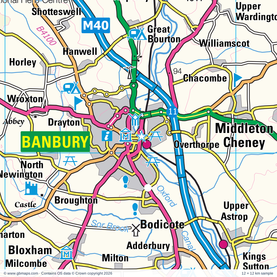
Banbury regional road map. Full 60 × 60 km PDF, SVG and Illustrator files, with a free PDF sample.

GBMAPS.COM

Banbury Regional Road Map

Call Us Now for Help01751 473136

GREAT BRITAIN ROAD ATLAS · 1:250,000 GB-450-0240

Banbury & surrounding area

Explore the full 60 × 60 km Banbury regional road map at 1:250,000, covering Brackley, Bicester, Buckingham, Towcester, Southam. Compare the complete coverage below; a detailed PDF sample is available free.

BANBURY & SURROUNDING AREAREGIONAL ROAD MAP
60 × 60 km · Full map previewDownload the free SVG ↓

INSIDE THE FULL 60 × 60 KM MAP

Explore the Banbury map area

1:250,000 cartography

Towns, villages & places

More mapped places (345)
  • Bodicote
  • Charlton
  • Adderbury
  • Greatworth
  • Williamscot
  • Wardington
  • Halse
  • Aynho
  • Milton
  • Cropredy
  • Drayton
  • Hanwell
  • Broughton
  • Croughton
  • Sulgrave
  • Edgcote
  • Bloxham
  • Culworth
  • Clifton
  • Radstone
  • Souldern
  • Chipping Warden
  • Deddington
  • Horley
  • Wroxton
  • Barford St John
  • Shotteswell
  • Helmdon
  • Mollington
  • Hempton
  • Evenley
  • Lower Tadmarton
  • Milcombe
  • Turweston
  • Aston le Walls
  • Whitfield
  • Fritwell
  • Juniper Hill
  • Tadmarton
  • Claydon
  • Balscote
  • Eydon
  • Somerton
  • Weston
  • Shutford
  • Crowfield
  • Warmington
  • Farnborough
  • Hornton
  • Swalcliffe
  • Mixbury
  • Alkerton
  • Cottisford
  • Over Worton
  • Hardwick
  • Westbury
  • Wigginton
  • Syresham
  • Hinton
  • Shenington
  • Byfield
  • Ardley
  • Biddlesden
  • Stoke Lyne
  • Wappenham
  • Ratley
  • Hethe
  • Ledwell
  • Burdrop
  • Wormleighton
  • Shalstone
  • Epwell
  • Edgehill
  • Woodend
  • Adstone
  • Swerford
  • Fringford
  • Bainton
  • Radway
  • Finmere
  • Caulcott
  • Bucknell
  • Slapton
  • Westcott Barton
  • Rousham
  • Blakesley
  • Abthorpe
  • Lower Tysoe
  • Maidford
  • Upper Tysoe
  • Charwelton
  • Northend
  • Dadford
  • Bradden
  • Caversfield
  • Tingewick
  • Silverstone
  • Winderton
  • Gagingwell
  • Knightcote
  • Chetwode
  • Hellidon
  • Radford
  • Ascott
  • Radclive
  • Godington
  • Farthingstone
  • Chackmore
  • Kiddington
  • Tackley
  • Chesterton
  • Whichford
  • Heythrop
  • Oxhill
  • Cleveley
  • Greens Norton
  • Whittlebury
  • Upper Catesby
  • Gaydon
  • Litchborough
  • Little Kineton
  • Glympton
  • Kineton
  • Enstone
  • Everdon
  • Chadshunt
  • Badby
  • Gawcott
  • Launton
  • Grimscote
  • Duncote
  • Kirtlington
  • Whatcote
  • Stourton
  • Poundon
  • Ladbroke
  • Fulwell
  • Wood Burcote
  • Wootton
  • Akeley
  • Cherington
  • Newnham
  • Wendlebury
  • Twyford
  • Staverton
  • Hillesden
  • Pury End
  • Idlicote
  • Upper Stowe
  • Astcote
  • Pattishall
  • Bletchingdon
  • Fulready
  • Combrook
  • Lighthorne
  • Eastcote
  • Taston
  • Paulerspury
  • Hulcote
  • Leckhampstead
  • Tiffield
  • Ambrosden
  • Charndon
  • Willington
  • Weedon Bec
  • Dodford
  • Barcheston
  • Dean
  • Flecknoe
  • Merton
  • Chesterton
  • Harbury
  • Spelsbury
  • Burmington
  • Blackthorn
  • Honington
  • Padbury
  • Calvert
  • Salford
  • Thrupp
  • Tidmington
  • Halford
  • Wicken
  • Stockton
  • Tredington
  • Ettington
  • Bugbrooke
  • Shutlanger
  • Chadlington
  • Alderton
  • Fencott
  • Flore
  • Edgcott
  • Ufton
  • Thornborough
  • Gayton
  • Stonesfield
  • Walton
  • Combe
  • Thornton
  • Bascote
  • Murcott
  • Oddington
  • Adstock
  • Bladon
  • Norton
  • Sawbridge
  • Islip
  • Blackwell
  • Armscote
  • Potterspury
  • Begbroke
  • Shorthampton
  • Fawler
  • Brockhall
  • Ashorne
  • Cornwell
  • Blisworth
  • Broadwell
  • Braunston
  • Piddington
  • Todenham
  • Sarsden
  • Darlingscott
  • Addington
  • Wellesbourne
  • Grandborough
  • Long Hanborough
  • Churchill
  • Welton
  • Rothersthorpe
  • Beachampton
  • East End
  • Noke
  • Chilson
  • Willoughby
  • Chastleton
  • Hill
  • Loxley
  • Yarnton
  • Crimscote
  • Ludgershall
  • Long Buckby Wharf
  • Kislingbury
  • Finstock
  • Old Stratford
  • Woolscott
  • Botolph Claydon
  • Harpole
  • Whilton
  • Woodeaton
  • Alderminster
  • Roade
  • Ashton
  • Freeland
  • Kingswood
  • Boarstall
  • Ramsden
  • Adlestrop
  • Nobottle
  • Nash
  • Charlecote
  • Ilmington
  • Courteenhall
  • Cosgrove
  • Daylesford
  • Kingham
  • Offchurch
  • Cassington
  • Calverton
  • Collingtree
  • Lyneham
  • Evenlode
  • Wimpstone
  • Elsfield
  • Charingworth
  • Beckley
  • Wasperton
  • Castlethorpe
  • Brill
  • Marton
  • Hartwell
  • Admington
  • Draycote
  • Delly End
  • Hunningham
  • Bledington
  • Granborough
  • Watford
  • Leafield
  • Harlestone
  • Barford
  • Foscot
  • Hailey
  • Eathorpe
  • Oakley
  • Alveston
  • Dorton
  • Quainton
  • Westcott
  • Wappenbury
  • Tiddington
  • Broadwell
  • Sherbourne
  • Crawley
  • Longbridge
  • Cubbington
  • Fordwells
  • East Haddon
  • Ashendon
  • Idbury
  • Ingon
  • Icomb
  • Waddesdon
  • Fifield
  • Pitchcott
  • Old Milverton
  • Oving
  • Holdenby
  • Chilton
  • Snitterfield
  • Hill Wootton
  • Easington
  • Swinbrook
  • Asthall
  • Budbrooke
  • Boughton
  • Lower Winchendon
  • Fulbrook
  • Chearsley
  • Wolverton
  • Taynton
  • Cuddington
  • Pitsford
  • Hatton
  • Hatton Green
  • Moulton
  • Gibraltar
  • Dinton
  • Upton
  • Shrewley
  • Stone
  • Westwell
  • Holcot
  • Rowington

Roads across this sheet

M1, M40, A40, A41, A43, A44, A45, A361, A413, A418, A421, A422, A423, A424, A425, A426, A428, A429, A436, A439, A445, A452, A455, A508

More road numbers

A3400, A4095, A4144, A4165, A4177, A4189, A4256, A4260, A4390, A4421, A4500, A4501, A5076, A5095, A5101, A5123, A5199, B430, B526, B4011, B4020, B4022, B4026, B4027, B4030, B4031, B4032, B4033, B4035, B4036, B4037, B4038, B4047, B4081, B4086, B4087, B4099, B4100, B4113, B4115, B4425, B4437, B4439, B4449, B4450, B4451, B4452, B4453, B4455, B4463, B4477, B4479, B4525, B4632, B5346, B5383, B5385

Rivers & waterways

Grand Union Canal, Oxford Canal, River Avon, River Cherwell, River Dorn, River Evenlode, River Glyme, River Great Ouse, River Leam, River Nene, River Ray, River Stour

More waterways

River Swere, River Thame, River Thames or Isis, River Tove, River Windrush, Sor Brook, Stratford-upon-Avon Canal

Landmarks & landscape

Abington Museum, Althorp, Aynho Park, Banbury Museum and Tooleys Boatyard, Barnes Meadow Nature Reserve, Bernwood Forest Nature Reserve, Blenheim Palace, Blenheim Palace and Garden (World Heritage Site), Bloxham Village Museum, Boarstall Duck Decoy, Boarstall Tower, Brampton Valley Way

More named features

Brill Windmill, Brixworth Country Park, Brixworth Country Park Visitor Centre, Brook Cottage Garden, Broughton Castle, Buckinghamshire Railway Centre, Burnums Farmyard Museum, Burton Dassett Hills Country Park, Bygones Museum, Calvert Jubilee Nature Reserve, Canons Ashby, Castleton House, Catanger Farm, Catanger Llamas, Cathedral of Our Lady and St Thomas of Canterbury Martyr, Central Museum & Art Gallery, 78 Derngate (The Charles Rennie Mackintosh House and Galleries, Charlbury Museum, Charlecote Mill, Charlecote Park, Chastleton House, Chipping Norton, Claydon House, Combe Mill Museum, Compton Verney House, Compton Verney House with major art gallery, Compton Wynyates, Daventry Country Park, Deddington Castle (Earthworks), Delapre Abbey, Draycote Water Visitor Centre, Everdon Stubbs Woodland Trust Wood Nature Reserve, Farnborough Hall, Hatton Country World, Heritage Motor Centre, Heythrop Hall Hotel, Golf & Country Club, Hoar Park Children's Farm, Honington Hall, Hook Norton Brewery, Hook Norton Pottery, Hunsbury Hill Country Park, Leamington Spa Art Gallery & Museum, Long Buckby Castle, Minster Lovell Hall & Dovecote, Museum of Country Bygones, National Herb Centre, National Waterways Museum, Stoke Bruerne, Nether Winchendon House, New Place & Nash's House, Shakespeare's Birtplace, Anne Hathaway's Cottage, Hall's Croft, Harvard House, Newbold Comyn Park, North Leigh Roman Villa, Northampton & Lamport Railway (Preserved Railway), Northamptonshire Ironstone Railway Museum, Old Dairy Farm Centre, Old Gaol Museum, Oxford Bus Museum, Quainton Windmill, ROMAN VILLA (remains of), Redwings Horse Sanctuary, Rollright Stones, Rookery Farm (Working Farm), Rousham Park House, Rowles Solar Farm, Royal Shakespeare Theatre, Saltisford Canal Centre, Shacks Barn Solar Farm, Shakespearience, Shakespeare's Birthplace Museum, Hall's Croft Museum, The Falstaff Experience, Silverstone Motor Racing Circuit, Spiceball Country Park, St James' Lake Nature Reserve, St Johns Museum, Warwickshire Museum, The Queens Own Hussars Museum, Warks Yeomanry & Warwick Town Museum, Startford Butterfly Farm, Stony Stratford Nature Reserve, Stowe House, Stowe Landscape Gardens, Stowe School, Sulgrave Manor, Swalcliffe Barn, The Mill Arts Centre, The Oxfordshire Museum, The Waterfowl Sanctuary and Childrens Farm, Tolsey Museum, Towcester Racecourse, Upton House, Victoria Park, Waddesdon Manor, Waddesdon Manor and Garden, Warwick Castle, Warwick Racecourse, Warwickshire Exhibition Centre, Welcombe Hills Country Park, Welcombe Hills Local Nature Reserve, Wellesbourne Airfield Museum, Wellesbourne Watermill, Whilton Locks Pottery, Whilton Mill, Winston Churchill's Grave, Wroxton Abbey
Local authority & parish coverage

Wholly or partly within the full map rectangle. These boundaries are coverage information, not additional artwork layers.

  • BuckinghamshirePartly within
  • Cherwell DistrictPartly within
  • Cotswold DistrictPartly within
  • Milton KeynesPartly within
  • Oxford DistrictPartly within
  • Rugby DistrictPartly within
  • South Oxfordshire DistrictPartly within
  • Stratford-on-Avon DistrictPartly within
  • Vale of White Horse DistrictPartly within
  • Warwick DistrictPartly within
  • West NorthamptonshirePartly within
  • West Oxfordshire DistrictPartly within
Wards & electoral divisions 140 areas
  • Abington & Phippsville Ward
  • Adderbury, Bloxham & Bodicote Ward
  • Alvescot and Filkins Ward (part)
  • Ascott and Shipton Ward
  • Aylesbury North West Ward (part)
  • Aylesbury West Ward (part)
  • Banbury Cross & Neithrop Ward
  • Banbury Grimsbury & Hightown Ward
  • Banbury Hardwick Ward
  • Banbury Ruscote Ward
  • Banbury, Calthorpe & Easington Ward
  • Berryfields, Buckingham Park & Watermead Ward (part)
  • Bicester East Ward
  • Bicester North & Caversfield Ward
  • Bicester South & Ambrosden Ward
  • Bicester West Ward
  • Billing Ward (part)
  • Bishop's Itchington, Fenny Compton & Napton Ward
  • Bishop's Tachbrook Ward
  • Blockley Ward (part)
  • Botley & Sunningwell Ward (part)
  • Brackley Ward
  • Brailes & Compton Ward
  • Braunston & Crick Ward (part)
  • Brixworth Ward (part)
  • Brize Norton and Shilton Ward (part)
  • Buckingham Ward
  • Budbrooke Ward
  • Burford Ward (part)
  • Campion Ward
  • Castle Ward
  • Chadlington and Churchill Ward
  • Charlbury and Finstock Ward
  • Chipping Norton Ward
  • Claverdon & Snitterfield Ward (part)
  • Cogenhoe & The Houghtons Ward (part)
  • Cropredy, Sibfords & Wroxton Ward
  • Cubbington & Leek Wootton Ward (part)
  • Cutteslowe & Sunnymead Ward (part)
  • Dallington Spencer Ward
  • Daventry North East Ward
  • Daventry North West Ward
  • Daventry South Ward
  • Deanshanger & Paulerspury Ward (part)
  • Deddington Ward
  • Ducklington Ward (part)
  • Dunsmore Ward (part)
  • Duston Ward
  • Eynsham and Cassington Ward (part)
  • Far Cotton, Delapre & Briar Hill Ward
  • Forest Hill & Holton Ward (part)
  • Fosseridge Ward (part)
  • Freeland and Hanborough Ward
  • Fringford & Heyfords Ward
  • Gaydon, Kineton & Upper Lighthorne Ward
  • Grendon Underwood & The Claydons Ward
  • Hackleton & Roade Ward (part)
  • Haddenham & Stone Ward (part)
  • Hailey, Minster Lovell and Leafield Ward (part)
  • Hanslope Ward (part)
  • Harbury Ward
  • Headlands Ward
  • Horwood Ward (part)
  • Hunsbury Ward
  • Kenilworth Abbey & Arden Ward (part)
  • Kenilworth St. John's Ward (part)
  • Kidlington East Ward (part)
  • Kidlington West Ward
  • Kingham, Rollright and Enstone Ward
  • Kingsley & Semilong Ward
  • Kingsthorpe North Ward
  • Kingsthorpe South Ward
  • Launton & Otmoor Ward
  • Leam Valley Ward (part)
  • Leamington Brunswick Ward
  • Leamington Clarendon Ward
  • Leamington Lillington Ward
  • Leamington Milverton Ward
  • Leamington Willes Ward
  • Long Buckby Ward (part)
  • Long Crendon Ward (part)
  • Long Marston Ward (part)
  • Middleton Cheney Ward
  • Milton-under-Wychwood Ward
  • Moreton East Ward
  • Moreton West Ward (part)
  • Moulton Ward (part)
  • Naseby Ward (part)
  • Nene Valley Ward
  • Newton Longville Ward (part)
  • North Leigh Ward
  • Northleach Ward (part)
  • Parklands Ward
  • Quainton Ward (part)
  • Quinton Ward (part)
  • Radford Semele Ward (part)
  • Rural North East Ward (part)
  • Rural South Northamptonshire Ward
  • Shipston North Ward
  • Shipston South Ward
  • Southam East, Central & Stockton Ward
  • Southam North & Long Itchington Ward
  • Southam South Ward
  • Southam West Ward
  • Stonesfield and Tackley Ward
  • Stony Stratford Ward (part)
  • Stow Ward (part)
  • Stratford Avenue Ward (part)
  • Stratford Clopton Ward (part)
  • Stratford Guildhall & Bridgetown Ward (part)
  • Stratford Orchard Hill Ward (part)
  • Stratford Shottery Ward (part)
  • Stratford Tiddington Ward
  • Stratford Welcombe Ward (part)
  • Talavera Ward (part)
  • The Bartons Ward
  • The Rissingtons Ward (part)
  • Towcester Ward
  • Tredington Ward
  • Tysoe Ward
  • Upton Ward
  • Waddesdon Ward (part)
  • Warwick All Saints & Woodloes Ward
  • Warwick Aylesford Ward
  • Warwick Myton & Heathcote Ward
  • Warwick Saltisford Ward
  • Wellesbourne East & Rural Ward
  • Wellesbourne North & Rural Ward
  • Wellesbourne South Ward
  • Weston Favell & Abington Vale Ward (part)
  • Whitnash Ward
  • Winslow Ward
  • Witney Central Ward (part)
  • Witney East Ward (part)
  • Witney North Ward
  • Witney West Ward (part)
  • Wolvercote Ward (part)
  • Wolverton Ward (part)
  • Woodford & Weedon Ward
  • Woodstock and Bladon Ward
Civil parishes & communities 503 areas
  • Abthorpe CP
  • Adderbury CP
  • Addington CP
  • Adlestrop CP
  • Admington CP (part)
  • Adstock CP
  • Adstone CP
  • Akeley CP
  • Alderminster CP
  • Alderton CP
  • Althorp CP
  • Ambrosden CP
  • Ardley CP
  • Arncott CP
  • Ascott-under-Wychwood CP
  • Ashby St. Ledgers CP
  • Ashendon CP
  • Ashow CP (part)
  • Ashton CP
  • Asthall CP (part)
  • Aston Le Walls CP
  • Atherstone on Stour CP (part)
  • Avon Dassett CP
  • Aylesbury CP (part)
  • Aynho CP
  • Badby CP
  • Banbury CP
  • Barby CP (part)
  • Barcheston CP
  • Barford CP
  • Barford St. John and St. Michael CP
  • Barrington CP (part)
  • Barton Hartshorn CP
  • Barton-on-the-Heath CP
  • Batsford CP (part)
  • Beachampton CP
  • Beausale, Haseley, Honiley and Wroxall CP (part)
  • Beckley and Stowood CP (part)
  • Begbroke CP
  • Berryfields CP (part)
  • Bicester CP
  • Biddlesden CP
  • Billing CP (part)
  • Birdingbury CP
  • Bishop's Itchington CP
  • Bishop's Tachbrook CP
  • Blackdown CP
  • Blackthorn CP
  • Bladon CP
  • Blakesley CP
  • Bledington CP
  • Blenheim CP
  • Bletchingdon CP
  • Blisworth CP
  • Blockley CP (part)
  • Bloxham CP
  • Boarstall CP
  • Boddington CP
  • Bodicote CP
  • Boughton CP
  • Bourton CP
  • Bourton and Draycote CP (part)
  • Bourton-on-the-Hill CP (part)
  • Brackley CP
  • Bradden CP
  • Brailes CP
  • Braunston CP
  • Brill CP
  • Brington CP
  • Brixworth CP (part)
  • Brize Norton CP (part)
  • Broadwell CP (part)
  • Brockhall CP
  • Broughton CP
  • Bruern CP
  • Buckingham CP
  • Bucknell CP
  • Budbrooke CP
  • Bugbrooke CP
  • Burford CP (part)
  • Burmington CP
  • Burton Dassett CP
  • Butlers Marston CP
  • Byfield CP
  • Calvert Green CP
  • Calverton CP (part)
  • Canons Ashby CP
  • Cassington CP (part)
  • Castlethorpe CP (part)
  • Catesby CP
  • Caversfield CP
  • Chacombe CP
  • Chadlington CP
  • Chadshunt CP
  • Chapel Ascote CP
  • Charlbury CP
  • Charlecote CP
  • Charlton-on-Otmoor CP
  • Charndon CP
  • Charwelton CP
  • Chastleton CP
  • Chearsley CP (part)
  • Cherington CP
  • Chesterton CP
  • Chesterton and Kingston CP
  • Chetwode CP
  • Chilson CP
  • Chilton CP (part)
  • Chipping Norton CP
  • Chipping Warden and Edgcote CP
  • Church with Chapel Brampton CP
  • Churchill CP
  • Claverdon CP (part)
  • Claydon with Clattercot CP
  • Clifford Chambers and Milcote CP (part)
  • Cold Higham CP
  • Coldharbour CP (part)
  • Collingtree CP
  • Combe CP
  • Combrook CP
  • Compton Verney CP
  • Compton Wynyates CP
  • Cornbury and Wychwood CP
  • Cornwell CP
  • Cosgrove CP (part)
  • Cottisford CP
  • Courteenhall CP
  • Crawley CP
  • Crick CP (part)
  • Cropredy CP
  • Croughton CP
  • Cubbington CP (part)
  • Cuddington CP (part)
  • Culworth CP
  • Curbridge CP (part)
  • Daventry CP
  • Deanshanger CP
  • Deddington CP
  • Dinton-with-Ford and Upton CP (part)
  • Dodford CP
  • Donnington CP (part)
  • Dorton CP
  • Drayton CP
  • Dunchurch CP (part)
  • Duns Tew CP
  • Duston CP
  • East Claydon CP
  • East Haddon CP (part)
  • East Hunsbury CP
  • Easton Neston CP
  • Eathorpe CP (part)
  • Ebrington CP (part)
  • Edgcott CP
  • Elsfield CP (part)
  • Enstone CP
  • Epwell CP
  • Ettington CP
  • Evenley CP
  • Evenlode CP
  • Everdon CP
  • Eydon CP
  • Eynsham CP (part)
  • Fairfields CP (part)
  • Far Cotton and Delapre CP
  • Farnborough CP
  • Farthinghoe CP
  • Farthingstone CP
  • Fawler CP
  • Fawsley CP
  • Fencott and Murcott CP
  • Fenny Compton CP
  • Fifield CP
  • Finmere CP
  • Finstock CP
  • Fleet Marston CP
  • Flore CP
  • Foscott CP
  • Frankton CP (part)
  • Freeland CP
  • Fringford CP
  • Fritwell CP
  • Fulbrook CP
  • Fulbrook CP
  • Gawcott with Lenborough CP
  • Gaydon CP
  • Gayton CP
  • Glympton CP
  • Godington CP
  • Gosford and Water Eaton CP (part)
  • Grafton Regis CP
  • Granborough CP
  • Grandborough CP (part)
  • Grange Park CP
  • Great Horwood CP (part)
  • Great Houghton CP (part)
  • Great Rissington CP (part)
  • Great Tew CP
  • Great Wolford CP
  • Greatworth and Halse CP
  • Greens Norton CP
  • Grendon Underwood CP
  • Hackleton CP (part)
  • Haddenham CP (part)
  • Hailey CP
  • Halford CP
  • Hampton Gay and Poyle CP
  • Hampton Lucy CP
  • Hanborough CP
  • Hanslope CP (part)
  • Hanwell CP
  • Harbury CP
  • Hardingstone CP
  • Hardwick CP (part)
  • Hardwick with Tusmore CP
  • Harlestone CP
  • Harlestone Manor CP
  • Harpole CP
  • Hartwell CP (part)
  • Hatton CP
  • Hellidon CP
  • Helmdon CP
  • Hethe CP
  • Heyford Park CP
  • Heythrop CP
  • Hillesden CP
  • Hinton-in-the-Hedges CP
  • Hodnell and Wills Pastures CP
  • Hoggeston CP (part)
  • Hogshaw CP
  • Holcot CP (part)
  • Holdenby CP
  • Hollowell CP (part)
  • Honington CP
  • Hook Norton CP
  • Horley CP
  • Hornton CP
  • Horton-cum-Studley CP
  • Hunningham CP
  • Hunsbury Meadows CP
  • Icomb CP (part)
  • Idbury CP
  • Idlicote CP
  • Ilmington CP (part)
  • Islip CP
  • Kenilworth CP (part)
  • Kiddington with Asterleigh CP
  • Kidlington CP
  • Kilsby CP (part)
  • Kineton CP
  • Kingham CP
  • Kings Sutton CP
  • Kingsthorpe CP
  • Kingswood CP
  • Kirtlington CP
  • Kislingbury CP
  • Ladbroke CP
  • Langley CP (part)
  • Launton CP
  • Leafield CP
  • Leamington Hastings CP
  • Leckhampstead CP
  • Leek Wootton and Guy's Cliffe CP (part)
  • Lighthorne CP
  • Lillingstone Dayrell with Luffield Abbey CP
  • Lillingstone Lovell CP
  • Litchborough CP
  • Little Compton CP
  • Little Horwood CP (part)
  • Little Houghton CP (part)
  • Little Rissington CP (part)
  • Little Tew CP
  • Little Wolford CP
  • Long Buckby CP (part)
  • Long Compton CP
  • Long Crendon CP (part)
  • Long Itchington CP
  • Longborough CP (part)
  • Lower Heyford CP
  • Loxley CP
  • Ludgershall CP
  • Lyneham CP
  • Maidford CP
  • Maids Moreton CP
  • Marsh Gibbon CP
  • Marston St. Lawrence CP
  • Marton CP
  • Maugersbury CP (part)
  • Merton CP
  • Middle Aston CP
  • Middle Claydon CP
  • Middleton Cheney CP
  • Middleton Stoney CP
  • Milcombe CP
  • Milton CP
  • Milton Malsor CP
  • Milton-under-Wychwood CP
  • Minster Lovell CP (part)
  • Mixbury CP
  • Mollington CP
  • Moreton Morrell CP
  • Moreton Pinkney CP
  • Moreton-in-Marsh CP (part)
  • Moulton CP
  • Mursley CP (part)
  • Napton on the Hill CP
  • Nash CP
  • Nether Heyford CP
  • Nether Winchendon CP
  • Newbold Pacey CP
  • Newbottle CP
  • Newnham CP
  • Newton Purcell with Shelswell CP
  • Noke CP
  • North Aston CP
  • North Leigh CP
  • North Marston CP
  • North Newington CP
  • Northampton CP (part)
  • Norton CP
  • Norton Lindsey CP
  • Oakley CP (part)
  • Oddington CP
  • Oddington CP
  • Offchurch CP
  • Old Milverton CP
  • Old Stratford CP
  • Over Norton CP
  • Overstone CP (part)
  • Overthorpe CP
  • Oving CP (part)
  • Oxhill CP
  • Padbury CP
  • Pattishall CP
  • Paulerspury CP
  • Piddington CP
  • Pillerton Hersey CP
  • Pillerton Priors CP
  • Pitchcott CP
  • Pitsford CP
  • Potterspury CP
  • Poundon CP
  • Prescote CP
  • Preston Bissett CP
  • Preston Capes CP
  • Preston on Stour CP (part)
  • Princethorpe CP (part)
  • Priors Hardwick CP
  • Priors Marston CP
  • Quainton CP
  • Quinton CP
  • Radbourn CP
  • Radclive-cum-Chackmore CP
  • Radford Semele CP
  • Radstone CP
  • Radway CP
  • Ramsden CP
  • Ratley and Upton CP
  • Ravensthorpe CP (part)
  • Roade CP
  • Rollright CP
  • Rothersthorpe CP
  • Rousham CP
  • Rowington CP (part)
  • Royal Leamington Spa CP
  • Salford CP
  • Sandford St. Martin CP
  • Sarsden CP
  • Sezincote CP (part)
  • Shalstone CP
  • Shenington with Alkerton CP
  • Sherbourne CP
  • Shilton CP (part)
  • Shipston on Stour CP
  • Shipton-on-Cherwell and Thrupp CP
  • Shipton-under-Wychwood CP
  • Shotteswell CP
  • Shrewley CP (part)
  • Shutford CP
  • Shutlanger CP
  • Sibford Ferris CP
  • Sibford Gower CP
  • Silverstone CP
  • Slapton CP
  • Snitterfield CP (part)
  • Somerton CP
  • Souldern CP
  • South Leigh and High Cogges CP (part)
  • South Newington CP
  • Southam CP
  • Spelsbury CP
  • Spratton CP (part)
  • Stanton St. John CP (part)
  • Staverton CP
  • Steeple Aston CP
  • Steeple Barton CP
  • Steeple Claydon CP
  • Stockton CP
  • Stoke Bruerne CP
  • Stoke Lyne CP
  • Stone with Bishopstone and Hartwell CP (part)
  • Stoneleigh CP (part)
  • Stonesfield CP
  • Stoneton CP
  • Stony Stratford CP (part)
  • Stourton CP
  • Stow-on-the-Wold CP (part)
  • Stowe CP
  • Stowe IX Churches CP
  • Stratford-upon-Avon CP (part)
  • Stratton Audley CP
  • Stretton-on-Fosse CP
  • Sulgrave CP
  • Sutton-under-Brailes CP
  • Swalcliffe CP
  • Swanbourne CP (part)
  • Swerford CP
  • Swinbrook and Widford CP
  • Syresham CP
  • Tackley CP
  • Tadmarton CP
  • Taynton CP
  • Thenford CP
  • Thornborough CP
  • Thornton CP
  • Thorpe Mandeville CP
  • Thurlaston CP (part)
  • Tidmington CP
  • Tiffield CP
  • Tingewick CP
  • Todenham CP
  • Towcester CP
  • Tredington CP
  • Turweston CP
  • Twyford CP
  • Tysoe CP
  • Ufton CP
  • Upper Heyford CP
  • Upper Heyford CP
  • Upper Lighthorne CP
  • Upper Rissington CP
  • Upper Winchendon CP
  • Upper and Lower Shuckburgh CP
  • Upton CP
  • Waddesdon CP
  • Wappenbury CP (part)
  • Wappenham CP
  • Wardington CP
  • Warkworth CP
  • Warmington CP
  • Warwick CP
  • Wasperton CP
  • Water Stratford CP
  • Watergall CP
  • Waterperry with Thomley CP (part)
  • Watford CP (part)
  • Weedon Bec CP
  • Wellesbourne and Walton CP
  • Welton CP
  • Wendlebury CP
  • West Haddon CP (part)
  • West Hunsbury CP
  • Westbury CP
  • Westcot Barton CP
  • Westcote CP
  • Westcott CP
  • Weston and Weedon CP
  • Weston under Wetherley CP (part)
  • Weston-on-the-Green CP
  • Westwell CP (part)
  • Whaddon CP (part)
  • Whatcote CP
  • Whichford CP
  • Whilton CP
  • Whitchurch CP (part)
  • Whitchurch CP
  • Whitfield CP
  • Whitnash CP
  • Whittlebury CP
  • Wick Rissington CP (part)
  • Wicken CP
  • Wigginton CP
  • Willoughby CP
  • Windrush CP (part)
  • Winslow CP
  • Witney CP (part)
  • Wolfhampcote CP
  • Wolverton CP (part)
  • Wolverton and Greenleys CP (part)
  • Woodeaton CP
  • Woodend CP
  • Woodford cum Membris CP
  • Woodham CP
  • Woodstock CP
  • Wootton CP
  • Wootton CP
  • Worminghall CP (part)
  • Wormleighton CP
  • Worton CP
  • Wotton Underwood CP
  • Wroxton CP
  • Wytham CP (part)
  • Yardley Gobion CP
  • Yarnton CP

Source: the GBMaps road atlas, OS Boundary-Line and postcode mapping datasets. Source editions are being checked for publication. Unmarked boundary names are wholly within the sheet; “part” means the map edge crosses the area.

Place lists are selected from the map source, not a complete gazetteer. Named features describe the cartography; visitor facilities and opening status are not verified. The free sample covers only 12 × 12 km of this larger sheet.

INSIDE YOUR DOWNLOAD

A proper road map, in useful formats

Road classifications, towns and villages, railways, rivers, landscape detail and tourist symbols, brought together in the GBMaps regional road atlas style.

PDF filePDFSVG fileSVGAdobe Illustrator AI fileAi

PDF for the finished map. SVG and layered Illustrator artwork for adapting colours, adding your own information and preparing designs.

THE FINISHED SHEET

Designed for print and presentation

Map coverage
60 × 60 km
Sample coverage
12 × 12 km
Print layout
A3 landscape · enlarged 1:250k cartography
Sheet furniture
Border, scale bar, key & north arrow

A few useful details

What changes when I select another square?

Select a surrounding square to bring it into the centre and reveal the maps around it. Each square is a different 60 × 60 km map. The preview, free sample and selected download change together. Neighbouring sheets overlap by 30 km so you can choose the coverage that suits you.

Is the free sample a vector map?

The on-page detail is an SVG. The free download is a separate 12 × 12 km PDF with a link to the full map. Please retain its copyright credits and product link when sharing it.

Can I buy a larger combined map?

These downloads are individual ready-made sheets. Contact GBMaps if you need a larger combined area.

FREE PDF SAMPLE

Your free map sample

Your free 12 × 12 km sample includes a link back to this map, so you can return for the full area whenever you need it.

Download free PDF sample ↓

Get your Banbury map

Map download bundle

£24.00including VATOne payment

Pay securely

One payment. Your map stays open.

Your map download

Your map files

Preparing your download…

Checking your private download link…

Your map downloads

Already bought a map?

Find the downloads from your purchases.

Enter the email address you used at checkout. We’ll email you a private link to your available map downloads.