Maptive is a broad business mapping platform, but many small UK delivery, sales and franchise teams do not need a large annual software plan. If your territories change only occasionally, a focused postcode map tool can be easier to use and much less expensive.
Quick answer
GB Maps is our best Maptive alternative for a small UK business that needs to colour postcode districts by hand or from a spreadsheet. The UK postcode district map costs £21.61 plus VAT for one user and one map type. The one-off payment gives 12 months of access, unlimited designs for that map, and no automatic renewal.
- Choose GB Maps for stable sales territories, delivery zones and a polished PDF.
- Choose VectorMaps.uk when you need a more advanced map, a wider boundary catalogue, GIS output or an API workflow.
- Choose Maptive, eSpatial or Mapline when routes, live operational data, collaboration or frequent territory changes are central to the job.
- Choose QGIS when you have GIS knowledge and want full technical control without a software licence fee.
How we selected the alternatives
We gave most weight to the needs of smaller UK businesses. These buyers usually need clear postcode boundaries, spreadsheet import, simple territory colours and a finished map that prints well. They do not always need daily route optimisation, demographic modelling, CRM connections or a multi-user territory management system.
We compared each product by its main use, UK postcode fit, data workflow, output, price approach and likely learning time. We reviewed public product information rather than opening paid test accounts. Prices and plan details can change, so check the supplier before you buy. The Maptive prices in this guide were checked on 3 September 2026.
The best Maptive alternatives at a glance
| Product | Best for | Price approach | Main point to consider |
|---|---|---|---|
| 1. GB Maps | UK postcode sales territories, delivery zones and print-ready maps | One map type for 12 months; district map is £21.61 + VAT | No routing, demographics, CRM, API or team workspace |
| 2. VectorMaps.uk | Advanced vector maps, boundary data and professional output | Priced for the selected map or output | More options than a simple postcode colouring job needs |
| 3. eSpatial | Managed sales territories and business mapping | Business subscription or quote | Higher cost and more setup than a static territory map |
| 4. Maptitude | Desktop GIS, territory analysis and detailed planning | Paid software and data packages | Check that the required UK postcode data is included |
| 5. Mapline | Cloud mapping, operational data, routes and workflows | Subscription plans | Confirm the UK boundary level in the selected plan |
| 6. QGIS | Maximum GIS control without a software licence fee | Free and open source | You must source, prepare and maintain the boundary data |
| 7. Smappen | Drive-time areas, radius maps and location planning | Free and paid plans | Not designed mainly for hand-coloured UK postcode districts |
The benchmark
Why look for an alternative to Maptive?
Maptive can be a good choice when mapping is an active part of daily operations. It supports large location data sets and functions such as route optimisation, demographic analysis, CRM connections, APIs and team collaboration. Its UK GIS page states that a data set can contain up to 100,000 locations.
That broad feature set has a broad price. At the time of our check, Maptive listed a 45-day plan at $250, a Pro plan at $1,250 per year and a Team plan at $2,500 per year. See the current Maptive pricing and UK GIS features before you make a decision.
A smaller company may only update its territories a few times each year. In that case, the important result is often a clear shared map and a polished PDF for print. Paying for an ongoing operational platform can be unnecessary.
1. Best focused UK postcode map tool
GB Maps
Best for: Small delivery, sales and franchise teams that need stable territories and a clear map for print or sharing.
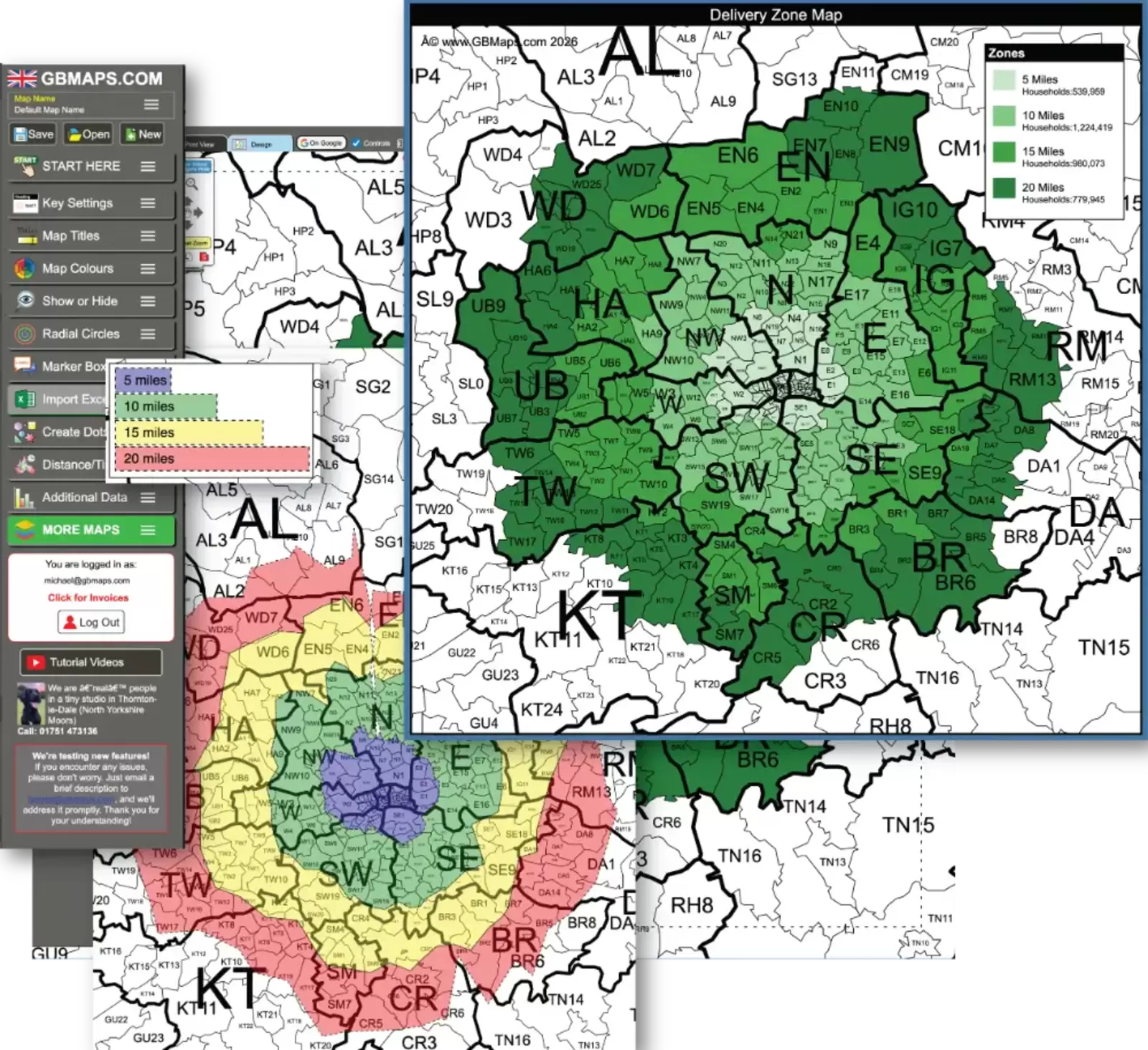
GB Maps is built around a simple result. Choose a boundary map, colour it by hand or use spreadsheet data, add the map information you need, and unlock the finished design. There are more than 60 map types for the UK and other parts of the world. UK options include postcode areas, districts and sectors, plus many administrative boundary maps.
You can test the map without an account, email address, time limit or payment card. The unpaid view contains a message and copyright protection to prevent clean screenshots. You give an email address when you save the map. After payment, the watermark is removed.
What GB Maps does well
- Colour postcode areas by hand or import all common CSV and Excel file types.
- Paste data directly from a spreadsheet.
- Match postcodes and assign or colour territories from the imported data.
- Add territory names, colours, values, map titles, labels, markers, distance circles and a legend with up to 52 zones.
- Use approximately 2,500 markers when the map needs customer, depot or franchise locations.
- Ignore an invalid postcode without stopping the rest of the import.
- Download PDF, PNG, SVG and CSV files.
- Use editable vector output for sharp printing at a large size.
- Publish a public interactive map, embed it on a website and update it without changing its link.
Price and licence
The popular UK postcode district map costs £21.61 plus VAT. Each map type has its own price so that a customer pays only for the map they need. One payment unlocks one map type for one user for 12 months. During that period, the user can save unlimited designs for that map. The payment is for commercial use and does not renew automatically.
Limits to know
- There is no route optimisation or demographic analysis.
- There are no CRM connections, API functions, team accounts or user permissions.
- The licence is for one user and one selected map type.
- The interactive shared map is public and expires when the licence expires.
- The site does not state a separate refund policy, so use the free trial to check the map before purchase.
2. Best advanced GB Maps option
VectorMaps.uk
Best for: Businesses that need more detailed map control, a much larger boundary catalogue, professional vector output or a map workflow that is closer to a full mapping platform.
VectorMaps.uk is the more advanced product from our team. Its catalogue contains more than 900 map boundaries. It also supports detailed street maps, worldwide map creation, high-resolution SVG and PDF output, and raw GPKG and GeoJSON files for GIS work. API options are available for organisations that need to generate maps from their own systems.
Reasons to choose it
- You need a boundary that is not available in the simpler GB Maps colouring tool.
- You want editable vector files for professional design or print work.
- You need raw GIS data for use in QGIS, ArcGIS or another system.
- You need to automate repeated map creation through an API.
For a simple postcode district territory map, start with GB Maps. For a more detailed specification or a technical output, review VectorMaps.uk.
3. Best for managed sales territories
eSpatial
Best for: A sales organisation that reviews territories regularly and needs structured territory management, customer data and collaboration.
eSpatial is closer to Maptive than GB Maps. It is designed for business data mapping and sales territory work. It can help a team view customer or account data, build territories and review how work is divided. This makes it more suitable when the territory map is an active management system rather than an occasional document.
Choose eSpatial when
- Several people need to work with the same sales territory data.
- Territories and account assignments change often.
- Sales coverage and workload analysis are more important than a low-cost printed map.
The extra management functions also bring more setup and a higher ongoing cost. Check the required UK postcode boundary level and current plan on the eSpatial website.
4. Best desktop mapping option
Maptitude
Best for: A user who wants desktop mapping software for detailed territory analysis, routing and planning.
Maptitude is a full desktop GIS and business mapping product. It can provide more analysis and control than a browser-based postcode colouring tool. It is a reasonable choice when the map user is comfortable with mapping software and expects to study territories rather than only present them.
Points to check before you buy
- Confirm that the licence includes the UK country package and postcode level you require.
- Check whether all members of the team need their own licence.
- Allow time for setup and training.
- Confirm that its print and export options match your production process.
See the current software and data options on the Maptitude website.
5. Best for online operational mapping
Mapline
Best for: Teams that need cloud mapping, routes, operational workflows and maps that change with business data.
Mapline is aimed at operational mapping rather than one finished territory document. It combines data mapping with functions for routes, territories and business workflows. This can be useful for a delivery or field team that works with changing location data each day.
Choose Mapline when
- The map must be connected to a repeated business process.
- Routes and field activity matter as much as territory colours.
- A subscription is acceptable because the system will be used often.
UK postcode coverage can differ by product and plan. Confirm the exact boundary layer you need before you pay. Review the current options on the Mapline website.
6. Best free technical option
QGIS
Best for: A technical user who wants maximum control and is willing to source and manage the map data.
QGIS is free, open-source desktop GIS software. It can create complex territory maps, join spreadsheet data to postcode polygons, style boundaries and build professional print layouts. It gives a capable user much more control than a simple online tool.
The software is free, but the completed map is not free of work. You must find boundary data with the correct licence, prepare the data, maintain it, configure the styles and build the print layout. QGIS also does not provide the same simple hosted sharing process as GB Maps.
Choose QGIS when
- You already understand GIS layers, joins, coordinate systems and print layouts.
- You need calculations or map rules that a ready-made tool cannot provide.
- You want to control the boundary data and production process yourself.
Download the software and read its documentation at QGIS.org.
7. Best for drive-time and radius areas
Smappen
Best for: Franchise planning, site selection and coverage questions based on travel time or distance.
Smappen answers a different type of territory question. It can help a business study the area that is reachable from a shop, depot or franchise location. This is useful when a 30-minute drive-time area is more meaningful than a fixed list of postcode districts.
It is not our first choice for a hand-coloured UK postcode district map or a print-first territory document. It is included because many franchise and delivery teams need to define coverage by travel time before they convert that coverage into postcode territories.
Review the current drive-time, radius and plan options on the Smappen website.
Maptive vs GB Maps for a small UK business
| Requirement | GB Maps | Maptive |
|---|---|---|
| UK postcode territory map | Focused on ready-made boundary maps | Part of a broader mapping platform |
| Postcode district price | £21.61 + VAT for 12 months | $250 for 45 days at the lowest listed term during our check |
| Automatic renewal | No | Check the selected Maptive plan terms |
| CSV and Excel data | Upload or paste data | Large business data imports |
| Manual territory colouring | Yes | Yes, within a wider mapping workflow |
| Print-ready output | PDF is a central output; SVG and PNG are also available | Export is available, but print is not the only purpose |
| Interactive sharing | Public link and website embed | Broader online map sharing and collaboration |
| Route optimisation | No | Yes |
| Demographic analysis | No | Yes |
| CRM and API functions | No | Yes |
| Team collaboration | One-user licence | Available in the broader platform |
| Best fit | Occasional territory updates and finished maps | Frequent operational mapping and analysis |
Which mapping tool should you choose?
Choose GB Maps
You need UK postcode sales or delivery territories, spreadsheet import and a clear PDF. The map changes only occasionally.
Create a district mapChoose VectorMaps.uk
You need one of more than 900 boundaries, advanced vector output, GIS files or map automation.
View VectorMaps.ukChoose Maptive or a business platform
You need routes, demographics, CRM data, collaboration or regular operational changes.
Review MaptiveHow to make a UK sales territory map from Excel
You do not need a full GIS platform for a normal postcode territory map. A typical GB Maps process is:
- Open the UK postcode district map.
- Upload a CSV or Excel file, or paste the spreadsheet data.
- Match the postcode districts and assign them to sales, franchise or delivery zones.
- Check the colours and make manual changes where necessary.
- Add a title, territory legend, labels, markers or distance circles.
- Save the map and buy the unlock when the design is ready.
- Download the PDF for a sharp print, or publish the interactive map for customers and staff.
Frequently asked questions
What is the best Maptive alternative for UK postcode mapping?
GB Maps is a focused choice for a small business that wants to colour UK postcode areas, districts or sectors and make a clear PDF map. It is not a route optimisation, demographic analysis or CRM platform.
Is there a cheaper UK alternative to Maptive?
Yes. The GB Maps UK postcode district tool costs £21.61 plus VAT for one user and 12 months of access. It does not renew automatically. Maptive has many more business functions, so compare the task as well as the price.
Can I create a UK postcode territory map from Excel?
Yes. GB Maps accepts CSV and Excel files, as well as data pasted from a spreadsheet. Postcodes can be matched and assigned to coloured territories.
Can I colour postcode districts by hand?
Yes. You can click and colour boundaries manually, use imported data, or combine both methods.
Can I buy territory mapping software without a subscription?
GB Maps uses a one-off payment for one selected map type. The unlock lasts for 12 months and does not renew automatically.
Can I download a territory map as a PDF or SVG?
Yes. GB Maps provides PDF, PNG, SVG and CSV downloads. PDF is the main print format, and the vector output remains sharp when it is enlarged.
Can I share or embed the map?
Yes. The unlocked map can be published with a public link and embedded on a website. You can update the map without changing its link. The shared map expires when the licence expires.
Does GB Maps replace every Maptive feature?
No. Choose Maptive or another business mapping platform if you need route optimisation, demographics, CRM connections, APIs, a team workspace or frequent operational changes.
What if I need a more advanced boundary map?
VectorMaps.uk is the more advanced product from our team. It has more than 900 map boundaries and supports professional vector, print, GIS and API workflows.
Product sources and checking date
We last reviewed the article details on 3 September 2026. We used our own current product specifications for GB Maps and VectorMaps.uk. The exact Maptive prices and limits were checked against its public product information. The other supplier descriptions are high-level and do not quote exact prices.
Build your own postcode territory map