Wrexham regional road map. Full 60 × 60 km PDF, SVG and Illustrator files, with a free PDF sample.

GBMAPS.COM

Wrexham Regional Road Map

Call Us Now for Help01751 473136

GREAT BRITAIN ROAD ATLAS · 1:250,000 GB-330-0330

Wrexham & surrounding area

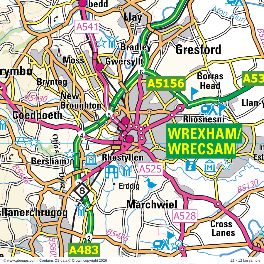
Explore the full 60 × 60 km Wrexham regional road map at 1:250,000, covering Wrexham, Oswestry, Chirk, Ellesmere, Llangollen. Compare the complete coverage below; a detailed PDF sample is available free.

WREXHAM & SURROUNDING AREAREGIONAL ROAD MAP
60 × 60 km · Full map previewDownload the free SVG ↓

INSIDE THE FULL 60 × 60 KM MAP

Explore the Wrexham map area

1:250,000 cartography

Towns, villages & places

More mapped places (330)
  • Llawnt
  • Trefonen
  • Selattyn
  • Morton
  • Croesau Bach
  • Rhydycroesau
  • Llynclys
  • Woolston
  • Treflach
  • Craignant
  • Rednal
  • Grimpo
  • Crickheath
  • St Martins
  • Porth-y-waen
  • Perthy
  • Bronygarth
  • Weirbrook
  • Nantmawr
  • Haughton
  • Pant
  • Hordley
  • Knockin
  • Eardiston
  • Maesbrook
  • Street Dinas
  • Llansilin
  • Tetchill
  • Llanyblodwel
  • Llanymynech
  • Dudleston Heath
  • Halton
  • Kinnerley
  • Dovaston
  • Pontfadog
  • Rhiwlas
  • Llwynmawr
  • Wykey
  • Lee
  • Bagley
  • Pentre
  • Domgay
  • Crosslanes
  • Froncysyllte
  • Newbridge
  • Llangadwaladr
  • Knolton
  • Moelfre
  • Pandy
  • Edgerley
  • Kinton
  • Cefn-mawr
  • Llandrinio
  • Glyn Ceiriog
  • Rhos
  • Tregeiriog
  • Llangedwyn
  • Erbistock
  • Acrefair
  • Nesscliffe
  • Cockshutt
  • Colemere
  • Garth
  • Wilcott
  • Melverley
  • Pentre
  • Overton
  • Deuddwr
  • Ruabon
  • Petton
  • Welshampton
  • Efail-rhyd
  • Llanfechain
  • Crewgreen
  • Baschurch
  • Arddleen
  • Lyneal
  • Criggion
  • Bwlchyddar
  • Pentrefelin
  • Waen Fach
  • Pen-y-cae
  • Penley
  • Gyfelia
  • Sarnau
  • Eyton
  • Burlton
  • Walford
  • Berwyn
  • Alberbury
  • Northwood
  • Bettisfield
  • Ensdon
  • Yeaton
  • Pentre
  • Loppington
  • Wolverley
  • Trefnanney
  • Middletown
  • Geuffordd
  • Shrawardine
  • Noneley
  • Wollaston
  • Newtown
  • Grafton
  • Myddle
  • Hanmer
  • Marchwiel
  • Rhostyllen
  • Fitz
  • Forton
  • Rhewl
  • Montford
  • Bersham
  • Pentre'r beirdd
  • Merrington
  • Rowton
  • Sleap
  • Glyndyfrdwy
  • Ford
  • Leaton
  • Cardeston
  • Guilsfield
  • Worthenbury
  • Penygarnedd
  • Alderton
  • Harmer Hill
  • Vennington
  • Paddolgreen
  • Stretton Heath
  • Threapwood
  • Bronington
  • Shoot Hill
  • Bicton
  • Coedpoeth
  • Yorton
  • Westbury
  • Minera
  • Welsh End
  • Buttington
  • Edstaston
  • Whixall
  • Penybontfawr
  • Meifod
  • Clive
  • Yockleton
  • Nox
  • Isycoed
  • Albrighton
  • Tycrwyn
  • Llan-y-pwll
  • Hope
  • Hollinwood
  • Grinshill
  • Brynteg
  • Bryneglwys
  • Carrog
  • Edge
  • Rowley
  • Aston
  • Gwersyllt
  • Shocklach
  • Bwlchgwyn
  • Ridleywood
  • Farley
  • Cruckton
  • Westley
  • Bradley
  • Brymbo
  • Asterley
  • Hadnall
  • Cruckmeole
  • Lea
  • Hinton
  • Llandegla
  • Hanwood
  • Alkington
  • Gresford
  • Llangynog
  • Brockton
  • Ffrith
  • Tilstock
  • Worthen
  • Pencraig
  • Leighton
  • Malpas
  • Prees
  • Astley
  • Besford
  • Binweston
  • Rhydtalog
  • Pontrobert
  • Llay
  • Pontesbury
  • Corwen
  • Pontesford
  • Minsterley
  • Hirnant
  • Plealey
  • Holt
  • Weston
  • Trelystan
  • Tilston
  • Llanfynydd
  • Leigh
  • Cynwyd
  • Cilcewydd
  • Annscroft
  • Farndon
  • Ploxgreen
  • Rhyd-y-meudwy
  • Shawbury
  • Graianrhyd
  • Stretton
  • Caergwrle
  • Booley
  • Llandrillo
  • Longden
  • Fron
  • Marton
  • Wagbeach
  • Pentre-celyn
  • Bayston Hill
  • Llwynderw
  • Uffington
  • Gwyddelwern
  • Glascoed
  • Llanelidan
  • Oaks
  • Darliston
  • Habberley
  • Burton
  • Wirswall
  • Rossett
  • Hope
  • Barton
  • Treuddyn
  • Snailbeach
  • Edgebolton
  • Ash Magna
  • Hope
  • Abertridwr
  • Churton
  • Meadowtown
  • Broughall
  • Haughton
  • Dolanog
  • Fauls
  • Duckington
  • Druid
  • Rorrington
  • Pontybodkin
  • Wotherton
  • Eryrys
  • Llanwddyn
  • Poynton
  • Clutton
  • Marchamley
  • Forden
  • Leeswood
  • Pulford
  • Gravels
  • Bryn Saith Marchog
  • Broxton
  • Pulverbatch
  • Roden
  • Bickerton
  • Marbury
  • Glan-yr-afon
  • Stapleton
  • Ightfield
  • Bickley
  • Muckleton
  • Derwen
  • Condover
  • Berriew
  • Norbury
  • Walton
  • Aldford
  • Chowley
  • Atcham
  • Efenechtyd
  • Maerdy
  • Melin-y-Wig
  • Dorrington
  • Harthill
  • Clocaenog
  • Great Ryton
  • Berrington
  • Little Ryton
  • Cantlop
  • Rodington
  • Llanfwrog
  • Manafon
  • Norton
  • Llanerfyl
  • Bulkeley
  • Tattenhall
  • Wroxeter
  • Burwardsley
  • Walcot
  • Chorley
  • Longnor
  • Llangadfan
  • Pitchford
  • Bontuchel
  • Frodesley
  • Donnington
  • Peckforton
  • Newton
  • Cound
  • Llanwyddelan
  • Uppington
  • Acton Pigott
  • Faddiley
  • Cyffylliog
  • Dryton
  • Llanllugan
  • Cefn Coch
  • Spurstow
  • Brindley
  • Beeston
  • Adfa
  • Haughton
  • Ruckley
  • Bunbury
  • Kenley
  • Calveley
  • Alpraham
  • Harley

Roads across this sheet

A41, A49, A51, A53, A458, A488, A490, A495, A525, A528, A530, A534, A539, A541, A542, A550, A5016, A5064, A5104, A5112, A5124, A5152, A5156, A5191

More road numbers

B4380, B4381, B4382, B4385, B4386, B4387, B4388, B4389, B4390, B4391, B4392, B4393, B4394, B4395, B4396, B4397, B4398, B4401, B4473, B4499, B4500, B4501, B4579, B4580, B5009, B5061, B5062, B5063, B5065, B5067, B5068, B5069, B5070, B5096, B5097, B5098, B5099, B5100, B5101, B5102, B5103, B5105, B5130, B5329, B5373, B5395, B5398, B5425, B5426, B5429, B5430, B5431, B5433, B5434, B5436, B5437, B5445, B5446, B5476, B5605

Rivers & waterways

Afon Alwen, Afon Banwy or Einion, Afon Ceirw, Afon Gam, Afon Tanat, Cound Brook, Ellesmere Canal, Llangollen Canal, Montgomery Canal, Montgomery Canal (Guilsfield Arm) (disused), River Alyn / Afon Alun, River Ceiriog

More waterways

River Clwyd / Afon Clwyd, River Dee / Afon Dyfrdwy, River Perry, River Rhiw / Afon Rhiw, River Roden, River Severn, River Tern, River Vyrnwy / Afon Efyrnwy, Shropshire Union Canal

Landmarks & landscape

Abbey, Acton Burnell Castle, Alyn Waters Country Park, Alyn Waters Country Park Visitor Centre, Andrew Logan Museum of Sculpture, Attingham, Attingham Park, Aviation Museum, Bangor-on-Dee Racecourse, Battlefield 1403 Exhibition Centre, Beeston Castle, Bersham Heritage Centre, SNOWDONIA NATIONAL PARK

More named features

Bersham Ironworks, Bodfach Hall, Bonc Y Hafod Country Park, Bunbury Watermill, Cambrian Heritage Railway, Cambrian Railway & Bicycle Museum, Cambrian Railways, Cane Workshop, Cantlop Bridge, Castle (remains of), Cheshire Candle Workshops, Cheshire Farm Ice Cream, Chirk Castle, Visitor Centre, Chirk Castle, Visitor Centre, Garden, Cholmondeley Castle, Cholmondeley Castle Gardens, Colemere Country Park, Derwen Churchyard Cross, Eastridge Wood Cycle Trail, Eliseg's Pillar, Erbistock Gardens, Erddig, Erddig Country Park, Eyton on Severn Point to Point Racecourse, Gaer Fawr Woods Nature Reserve, Goat Field Aboretum, Haughmond Abbey, Hawkstone Park and Visitor Centre, Hayford Solar Farm, Home Farm Attingham, Horseshoe Pass, Hotel, Lake Vyrnwy Visitor Centre, Langley Chapel, Llandegla Forest Visitor Centre, Llangar Church, Llangedwyn Mill Craft Workshops, Llangollen Motor Museum, Llangollen Railway, Llanymynech Heritage Area and Visitor Centre, Lyth Hill Country Park, Minera Lead Mines and Country Park, Moat House, Moreton Corbet Castle, Nant Mill Visitor Centre, Nantclwyd Hall, Nantclwyd y Dre, Nantmawr Quarry Mountain Bike Centre, Nesscliffe Hill Country Park, Old Oswestry Fort, Oriel Wrecsam, Oswestry Heritage and Exhibition Centre, Pandy Mill Studio, Park Hall Countryside Experience, Pen Y Bryn Farm, Plas Newydd, Llangollen Museum, Poles Coppice Nature Reserve, Pontcysyllte Aqueduct (World Heritage Site), Powis Castle, Powis Castle Gardens, Powysland Museum, Prees Branch Canal Nature Reserve, Pstyll Rhaeadr Beauty Spot, Rowley's House Museum, Coleham Pumping Station, Shropshire Regimental Museum, Shrewsbury Museum & Art Gallery, Rowton Castle, Royal International Pavilion, Ruewood Meadow Nature Reserve, Rug Chapel Visitor Centre, Ruthin Craft Centre, Severn Farm Pond, Shrewsbury Abbey, Shrewsbury Castle, Shropshire Wildlife Centre, Major Art Galleries, Snailbeach Mine, Solar Farm, Sontley Moor Nature Reserve, Stretton Watermill, The Dingle Gardens and Nursery, The Glassblobbery, The Mere, Visitor Centre, The Original Butterflyman, The Plassey Craft Centre, Ty Mawr Country Park, Valle Crucis Abbey (remains of), Vaynor Park, Visitor Centre, Waun-y-llyn Country Park, Welshpool & Llanfair Light Railway, Whitchurch Heritage Centre, Whittington Castle, Wrexham County Borough Museum, Wroxeter Roman City, Wroxeter Roman City and Museum, Wroxeter Roman Vineyard
Local authority & parish coverage

Wholly or partly within the full map rectangle. These boundaries are coverage information, not additional artwork layers.

  • Cheshire EastPartly within
  • Cheshire West and ChesterPartly within
  • Conwy - ConwyPartly within
  • Gwynedd - GwyneddPartly within
  • Powys - PowysPartly within
  • ShropshirePartly within
  • Sir Ddinbych - DenbighshirePartly within
  • Sir y Fflint - FlintshirePartly within
  • Telford and WrekinPartly within
  • Wrecsam - WrexhamPartly within
Wards & electoral divisions 139 areas
  • Audlem Ward (part)
  • Bunbury Ward (part)
  • Christleton & Huntington Ward (part)
  • Ercall Magna Ward (part)
  • Farndon Ward (part)
  • Malpas Ward
  • Tattenhall Ward (part)
  • Wrenbury Ward (part)
  • Wrockwardine Ward (part)
  • Abbey ED
  • Acrefair North ED
  • Acton and Maesydre ED
  • Alyn Valley ED
  • Bagley ED
  • Bangor Is-y-Coed ED
  • Banwy, Llanfihangel and Llanwddyn ED (part)
  • Battlefield ED
  • Bayston Hill ED
  • Belle Vue ED
  • Berriew and Castle Caereinion ED (part)
  • Bicton Heath ED
  • Bishop's Castle ED (part)
  • Borras Park ED
  • Bronington and Hanmer ED
  • Brymbo ED
  • Bryn Cefn ED
  • Brynyffynnon ED
  • Burnell ED (part)
  • Caergwrle ED
  • Cartrefle ED
  • Castlefields & Ditherington ED
  • Cefn East ED
  • Cefn West ED
  • Chirbury & Worthen ED (part)
  • Chirk North ED
  • Chirk South ED
  • Coedpoeth ED
  • Column & Sutton ED
  • Copthorne ED
  • Dyffryn Ceiriog ED
  • Edeirnion ED (part)
  • Efenechdyd ED
  • Ellesmere Urban ED
  • Erddig ED
  • Esclusham ED
  • Forden and Montgomery ED (part)
  • Garden Village ED
  • Gresford East and West ED
  • Grosvenor ED
  • Guilsfield ED
  • Gwenfro ED
  • Gwernaffield and Gwernymynydd ED (part)
  • Gwersyllt East ED
  • Gwersyllt North ED
  • Gwersyllt South ED
  • Gwersyllt West ED
  • Harlescott ED
  • Hermitage ED
  • Higher Kinnerton ED (part)
  • Hodnet ED (part)
  • Holt ED
  • Hope ED (part)
  • Leeswood ED (part)
  • Little Acton ED
  • Llandderfel ED (part)
  • Llandrinio ED
  • Llandyrnog ED (part)
  • Llandysilio ED
  • Llanfair Caereinion and Llanerfyl ED (part)
  • Llanfair Dyffryn Clwyd Gwyddelwern ED
  • Llanfyllin ED
  • Llanfynydd ED
  • Llangollen ED
  • Llangollen Rural ED
  • Llangyniew and Meifod ED
  • Llanrhaeadr-ym-Mochnant and Llansilin ED
  • Llanrhaeadr-yng-Nghinmeirch ED (part)
  • Llansantffraid ED
  • Llanymynech ED
  • Llay ED
  • Longden ED
  • Loton ED
  • Marchwiel ED
  • Marford and Hoseley ED
  • Meole ED
  • Minera ED
  • Moel Famau ED (part)
  • Monkmoor ED
  • Much Wenlock ED (part)
  • New Broughton ED
  • Offa ED
  • Oswestry North ED
  • Oswestry North East ED
  • Oswestry South ED
  • Oswestry South East ED
  • Oteley & Reabrook ED
  • Overton and Maelor South ED
  • Pant and Johnstown ED
  • Pen-y-ffordd ED (part)
  • Penycae ED
  • Penycae and Ruabon South ED
  • Ponciau ED
  • Porthill ED
  • Prees ED (part)
  • Quarry & Coton Hill ED
  • Queensway ED
  • Radbrook ED
  • Rea Valley ED
  • Rhiwcynon ED (part)
  • Rhos ED
  • Rhosnesni ED
  • Rossett ED (part)
  • Ruabon ED
  • Ruthin ED (part)
  • Ruyton & Baschurch ED
  • Selattyn & Gobowen ED
  • Severn Valley ED (part)
  • Shawbury ED (part)
  • Smithfield ED
  • St. Martin's ED
  • St. Oswald ED
  • Stansty ED
  • Sundorne & Old Heath ED
  • Tern ED
  • The Meres ED
  • Trelystan and Trewern ED
  • Treuddyn ED (part)
  • Underdale ED
  • Uwch Aled ED (part)
  • Welshpool Castle ED
  • Welshpool Gungrog ED
  • Welshpool Llanerchyddol ED
  • Wem ED
  • Whitchurch North ED
  • Whitchurch South ED (part)
  • Whitchurch West ED
  • Whitegate ED
  • Whittington ED
  • Wynnstay ED
Civil parishes & communities 226 areas
  • Abenbury Community
  • Acton Burnell CP
  • Acton Community
  • Agden CP
  • Alberbury with Cardeston CP
  • Aldersey CP
  • Aldford and Saighton CP (part)
  • Alpraham and Calveley CP (part)
  • Astley CP
  • Atcham CP
  • Baddiley CP (part)
  • Bangor is-y-Coed Community
  • Banwy Community (part)
  • Barton CP
  • Baschurch CP
  • Bausley with Criggion Community
  • Bayston Hill CP
  • Beeston CP (part)
  • Berriew Community (part)
  • Berrington CP
  • Betws Gwerfil Goch Community
  • Bickerton CP
  • Bicton CP
  • Bomere Heath and District CP
  • Brindley CP (part)
  • Bronington Community
  • Broughton Community
  • Broxton CP
  • Brymbo Community
  • Bryneglwys Community
  • Bulkeley and Ridley CP
  • Bunbury CP
  • Burland and Acton CP (part)
  • Burwardsley CP
  • Caia Park Community
  • Carden CP
  • Carreghofa Community
  • Castle Caereinion Community
  • Cefn Community
  • Ceiriog Ucha Community
  • Cerrigydrudion Community (part)
  • Chidlow CP
  • Chirbury with Brompton CP (part)
  • Chirk Community
  • Cholmondeley CP
  • Chorley CP
  • Chorlton CP
  • Chowley CP
  • Church Pulverbatch CP (part)
  • Churton CP
  • Clive CP
  • Clocaenog Community
  • Clutton CP
  • Cockshutt CP
  • Coddington CP
  • Coedpoeth Community
  • Condover CP
  • Corwen Community
  • Cound CP (part)
  • Cressage CP (part)
  • Cuddington CP
  • Cyffylliog Community
  • Cynwyd Community
  • Derwen Community
  • Dodcott cum Wilkesley CP (part)
  • Dodleston CP (part)
  • Duckington CP
  • Dwyriw Community (part)
  • Eaton and Eccleston CP (part)
  • Efenechtyd Community
  • Egerton CP
  • Ellesmere Rural CP
  • Ellesmere Urban CP
  • Erbistock Community
  • Ercall Magna CP (part)
  • Esclusham Community
  • Faddiley CP
  • Farndon CP
  • Ford CP
  • Forden with Leighton and Trelystan Community (part)
  • Frodesley CP (part)
  • Glyntraian Community
  • Golborne David CP (part)
  • Great Hanwood CP
  • Great Ness CP
  • Gresford Community
  • Grinshill CP
  • Guilsfield Community
  • Gwersyllt Community
  • Gwyddelwern Community
  • Hadnall CP
  • Handley CP
  • Hanmer Community
  • Harley CP (part)
  • Harthill CP
  • Haughton CP (part)
  • Higher Kinnerton Community (part)
  • Hodnet CP (part)
  • Holt Community
  • Hope Community (part)
  • Hordley CP
  • Ightfield CP (part)
  • Isycoed Community
  • Kenley CP (part)
  • Kinnerley CP
  • Knockin CP
  • Leebotwood CP (part)
  • Leeswood and Pontblyddyn Community (part)
  • Leighton and Eaton Constantine CP (part)
  • Little Ness CP
  • Llanarmon-yn-Ial Community
  • Llanbedr Dyffryn Clwyd Community (part)
  • Llandderfel Community (part)
  • Llandegla Community
  • Llandrillo Community (part)
  • Llandrinio Community
  • Llandysilio Community
  • Llanelidan Community
  • Llanerfyl Community (part)
  • Llanfair Caereinion Community
  • Llanfair Dyffryn Clwyd Community
  • Llanfechain Community
  • Llanferres Community (part)
  • Llanfihangel Community
  • Llanfihangel Glyn Myfyr Community (part)
  • Llanfyllin Community
  • Llanfynydd Community
  • Llangedwyn Community
  • Llangollen Community
  • Llangollen Rural Community
  • Llangwm Community (part)
  • Llangyniew Community
  • Llangynog Community (part)
  • Llangywer Community (part)
  • Llanrhaeadr-Yng-Nghinmeirch Community (part)
  • Llanrhaeadr-ym-Mochnant Community
  • Llansantffraid Community
  • Llansantffraid Glyn Ceiriog Community
  • Llansilin Community
  • Llantysilio Community
  • Llanwddyn Community (part)
  • Llanyblodwel CP
  • Llanymynech and Pant CP
  • Llanynys Community (part)
  • Llay Community
  • Longden CP
  • Longnor CP (part)
  • Loppington CP
  • Maelor South Community
  • Malpas CP
  • Manafon Community
  • Marbury and District CP
  • Marchwiel Community
  • Meifod Community
  • Melverley CP
  • Minera Community
  • Minsterley CP
  • Montford CP
  • Moreton Corbet and Lee Brockhurst CP
  • Myddle, Broughton and Harmer Hill CP
  • Nantglyn Community (part)
  • Nercwys Community (part)
  • Newhall CP (part)
  • No Man's Heath and District CP
  • Offa Community
  • Oswestry CP
  • Oswestry Rural CP
  • Overton Community
  • Peckforton CP
  • Pen-y-bont-Fawr Community
  • Penycae Community
  • Penyffordd Community (part)
  • Petton CP
  • Pitchford CP
  • Pontesbury CP
  • Poulton and Pulford CP (part)
  • Prees CP (part)
  • Ratlinghope CP (part)
  • Rhosddu Community
  • Rhosllanerchrugog Community
  • Rodington CP (part)
  • Rossett Community (part)
  • Ruabon Community
  • Ruckley and Langley CP (part)
  • Ruthin Community (part)
  • Ruyton-XI-Towns CP
  • Selattyn and Gobowen CP
  • Sesswick Community
  • Shawbury CP (part)
  • Shocklach Oviatt and District CP
  • Shrewsbury CP
  • Smethcott CP (part)
  • Spurstow CP
  • St. Martin's CP
  • Stanton upon Hine Heath CP (part)
  • Stretton CP
  • Tattenhall and District CP (part)
  • Threapwood CP
  • Tilston CP
  • Tiverton and Tilstone Fearnall CP (part)
  • Tregynon Community (part)
  • Treuddyn Community (part)
  • Trewern Community
  • Tushingham-cum-Grindley, Macefen and Bradley CP
  • Uffington CP
  • Upton Magna CP
  • Wardle CP (part)
  • Welshampton and Lyneal CP
  • Welshpool Community
  • Wem Rural CP
  • Wem Urban CP
  • West Felton CP
  • Westbury CP
  • Weston Rhyn CP
  • Weston-under-Redcastle CP
  • Whitchurch Rural CP (part)
  • Whitchurch Urban CP
  • Whittington CP
  • Whixall CP
  • Wigland CP
  • Willington Worthenbury Community
  • Withington CP
  • Worthen with Shelve CP (part)
  • Wrenbury cum Frith CP (part)
  • Wrockwardine CP (part)
  • Wroxeter and Uppington CP (part)

Source: the GBMaps road atlas, OS Boundary-Line and postcode mapping datasets. Source editions are being checked for publication. Unmarked boundary names are wholly within the sheet; “part” means the map edge crosses the area.

Place lists are selected from the map source, not a complete gazetteer. Named features describe the cartography; visitor facilities and opening status are not verified. The free sample covers only 12 × 12 km of this larger sheet.

INSIDE YOUR DOWNLOAD

A proper road map, in useful formats

Road classifications, towns and villages, railways, rivers, landscape detail and tourist symbols, brought together in the GBMaps regional road atlas style.

PDF filePDFSVG fileSVGAdobe Illustrator AI fileAi

PDF for the finished map. SVG and layered Illustrator artwork for adapting colours, adding your own information and preparing designs.

THE FINISHED SHEET

Designed for print and presentation

Map coverage
60 × 60 km
Sample coverage
12 × 12 km
Print layout
A3 landscape · enlarged 1:250k cartography
Sheet furniture
Border, scale bar, key & north arrow

A few useful details

What changes when I select another square?

Select a surrounding square to bring it into the centre and reveal the maps around it. Each square is a different 60 × 60 km map. The preview, free sample and selected download change together. Neighbouring sheets overlap by 30 km so you can choose the coverage that suits you.

Is the free sample a vector map?

The on-page detail is an SVG. The free download is a separate 12 × 12 km PDF with a link to the full map. Please retain its copyright credits and product link when sharing it.

Can I buy a larger combined map?

These downloads are individual ready-made sheets. Contact GBMaps if you need a larger combined area.

FREE PDF SAMPLE

Your free map sample

Your free 12 × 12 km sample includes a link back to this map, so you can return for the full area whenever you need it.

Download free PDF sample ↓

Get your Wrexham map

Map download bundle

£24.00including VATOne payment

Pay securely

One payment. Your map stays open.

Your map download

Your map files

Preparing your download…

Checking your private download link…

Your map downloads

Already bought a map?

Find the downloads from your purchases.

Enter the email address you used at checkout. We’ll email you a private link to your available map downloads.