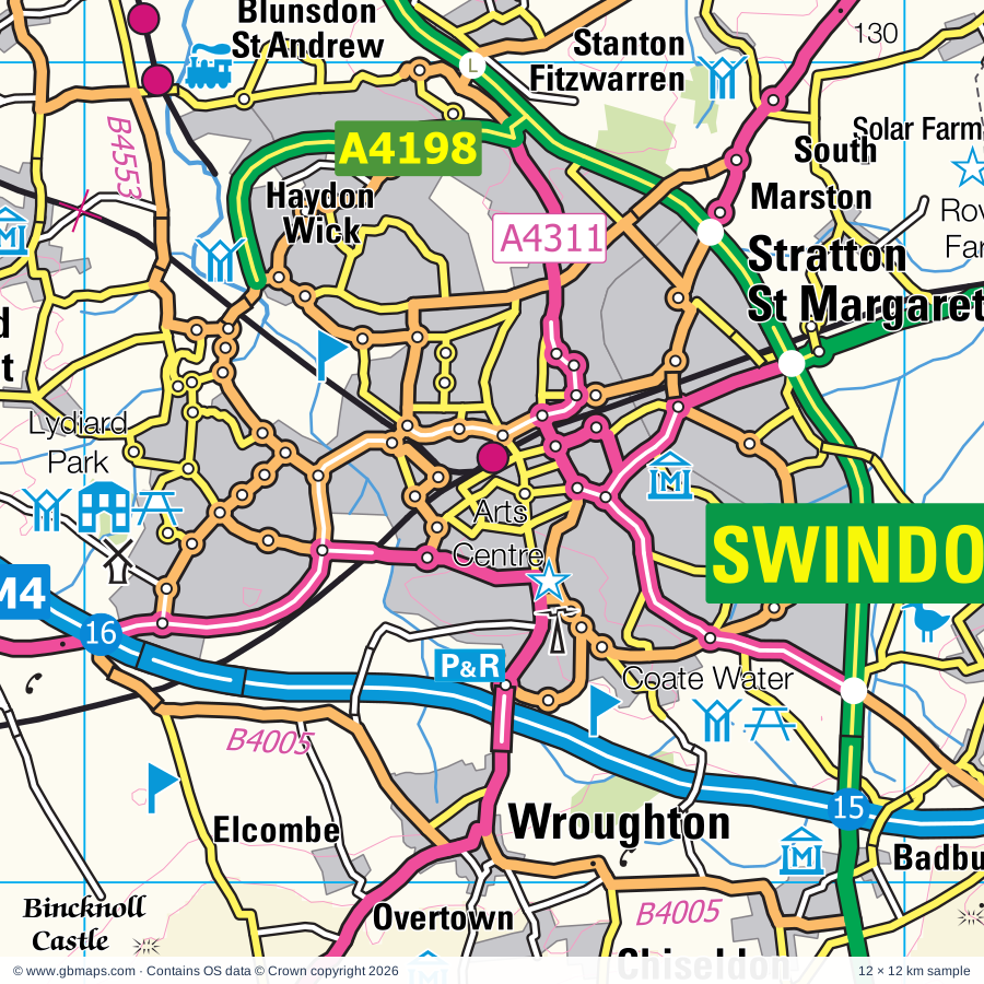
Swindon regional road map. Full 60 × 60 km PDF, SVG and Illustrator files, with a free PDF sample.

GBMAPS.COM

Swindon Regional Road Map

Call Us Now for Help01751 473136

GREAT BRITAIN ROAD ATLAS · 1:250,000 GB-420-0180

Swindon & surrounding area

Explore the full 60 × 60 km Swindon regional road map at 1:250,000, covering Marlborough, Highworth, Cricklade, Faringdon, Hungerford. Compare the complete coverage below; a detailed PDF sample is available free.

SWINDON & SURROUNDING AREAREGIONAL ROAD MAP
60 × 60 km · Full map previewDownload the free SVG ↓

INSIDE THE FULL 60 × 60 KM MAP

Explore the Swindon map area

1:250,000 cartography

Towns, villages & places

More mapped places (312)
  • Chiseldon
  • Liddington
  • Wanborough
  • Woodsend
  • Wroughton
  • Bishopstone
  • Elcombe
  • Idstone
  • Bourton
  • Uffcott
  • Aldbourne
  • Ashbury
  • Baydon
  • Rockley
  • Shrivenham
  • Broad Hinton
  • Mildenhall
  • Sevenhampton
  • Axford
  • Ramsbury
  • Broad Town
  • Watchfield
  • Whittonditch
  • Manton
  • Woolstone
  • Fyfield
  • Lambourn
  • Hook
  • Longcot
  • Purton
  • Hannington
  • Lockeridge
  • Cadley
  • Bushton
  • Uffington
  • Avebury
  • Coleshill
  • Eastbury
  • Fernham
  • Froxfield
  • Beckhampton
  • Chisbury
  • Clevancy
  • Yatesbury
  • Baulking
  • Tockenham
  • Durley
  • Grittenham
  • Preston
  • Sparsholt
  • Highway
  • Little Bedwyn
  • Callow Hill
  • Great Bedwyn
  • Huish
  • Kempsford
  • Lyneham
  • Childrey
  • Buscot
  • Shellingford
  • Oare
  • Dunfield
  • Leigh
  • Crofton
  • Goatacre
  • Hilmarton
  • West Challow
  • Bagshot
  • Latton
  • Cherhill
  • Brinkworth
  • Burbage
  • Fawley
  • Goosey
  • Wilton
  • Alton Priors
  • Wilcot
  • Bradenstoke
  • Kelmscott
  • Pewsey
  • Hatford
  • Alton Barnes
  • Littleworth
  • Shalbourne
  • Weston
  • Spirthill
  • Dauntsey
  • Horcott
  • Avington
  • Wickham
  • Allington
  • Ham
  • Radcot
  • Chaddleworth
  • Meysey Hampton
  • Marten
  • Denchworth
  • Woodborough
  • Rivar
  • Grafton
  • Welford
  • Blackland
  • All Cannings
  • Wexcombe
  • Horton
  • Kintbury
  • Grove
  • Brightwalton
  • Pusey
  • Cleverton
  • Bremhill
  • Buckland
  • Foxham
  • Inkpen
  • Poulton
  • Buttermere
  • Langford
  • Driffield
  • Oxenwood
  • Southrop
  • Stockley
  • Farnborough
  • Clanfield
  • Tidcombe
  • Upper Green
  • Beechingstoke
  • Halfway
  • Brunton
  • Aughton
  • East Tytherton
  • Fyfield
  • Coate
  • Wickham Heath
  • Boxford
  • Lyford
  • Shorncote
  • Leckhampstead
  • Harnhill
  • Broadwell
  • Garsdon
  • Heddington
  • Ardington
  • Filkins
  • Marden
  • Weald
  • Wilsford
  • Quenington
  • Studley
  • Etchilhampton
  • Roundway
  • Lea
  • Fosbury
  • Patney
  • East Hanney
  • Hankerton
  • West Ginge
  • Catmore
  • Oaksey
  • Rushall
  • Charlton
  • Kencot
  • Hatherop
  • Alvescot
  • Startley
  • Combe
  • Eastcourt
  • East Ginge
  • West Woodhay
  • Upavon
  • Siddington
  • Bampton
  • Preston
  • Peasemore
  • Derry Hill
  • Chirton
  • Stockcross
  • Chimney
  • Ewen
  • Everleigh
  • Milbourne
  • Wedhampton
  • Stert
  • Rodbourne
  • Winterbourne
  • Aston
  • Chelworth
  • Longworth
  • Cote
  • Bagnor
  • Kemble
  • West Ilsley
  • Stanmore
  • Linkenholt
  • Garford
  • Enborne
  • Corston
  • Chittoe
  • Bromham
  • Crudwell
  • Barnsley
  • Urchfont
  • Rowde
  • Shifford
  • Arlington
  • Chieveley
  • Bibury
  • East End
  • Chute Standen
  • Compton
  • Chedglow
  • Bradwell
  • Faccombe
  • Beedon
  • Fyfield
  • Enford
  • Longstreet
  • Lew
  • Ablington
  • Shilton
  • Holwell
  • East Ilsley
  • Yelford
  • Frilford
  • Upton
  • Chilton
  • Potterne
  • Milton Hill
  • Steventon
  • Brokenborough
  • Brighthampton
  • Eastcott
  • Stratton
  • Tubney
  • Curridge
  • Tangley
  • Baunton
  • Standlake
  • Poulshot
  • Highclere
  • Marcham
  • Harwell
  • Sells Green
  • Coates
  • Easterton
  • Ashley
  • Lacock
  • Winson
  • Longlane
  • Tarlton
  • Drayton
  • Milton
  • Ashmansworth
  • Notton
  • Seend
  • Culkerton
  • Rodmarton
  • Curbridge
  • Northmoor
  • Hardwick
  • Coln Rogers
  • Ducklington
  • Ibthorpe
  • Greenham
  • Newtown
  • Worton
  • Appleton
  • Daglingworth
  • Calmsden
  • Beanacre
  • Cothill
  • Wildhern
  • Marston
  • Burghclere
  • Hatherden
  • Whitway
  • Bagendon
  • Shippon
  • Bulkington
  • Bowerhill
  • Eaton
  • Sutton
  • Sapperton
  • Wootton
  • Stoke
  • Rendcomb
  • Binley
  • Old Burghclere
  • Woodmancote
  • Henwood
  • Cherington
  • Berryfield
  • Erlestoke
  • Cumnor
  • Keevil
  • Frampton Mansell
  • Coulston
  • Sydmonton
  • Sunningwell
  • Edgeworth
  • Farmoor
  • Litchfield
  • Eynsham
  • Swinford
  • Winstone
  • Edington
  • Sudgrove
  • Miserden
  • Bisley
  • Bratton
  • Wytham
  • Througham
  • Wolvercote

Roads across this sheet

M4, A4, A40, A338, A339, A342, A343, A345, A346, A350, A360, A361, A365, A415, A417, A419, A420, A429, A433, A435, A3026, A3102, A4095, A4130

More road numbers

A4144, A4183, A4185, A4198, A4259, A4289, A4311, A4312, A4313, A4361, B3048, B3052, B3087, B3098, B3101, B3421, B4000, B4001, B4003, B4005, B4006, B4009, B4014, B4016, B4017, B4019, B4020, B4022, B4040, B4042, B4044, B4069, B4070, B4122, B4141, B4143, B4158, B4192, B4289, B4425, B4449, B4477, B4493, B4494, B4507, B4508, B4528, B4534, B4553, B4587, B4640, B4643, B4696

Rivers & waterways

Back Water, Culham Cut, Kennet & Avon Canal, Oxford Canal, River Avon, River Bourne, River Churn, River Coln, River Evenlode, River Kennet, River Lambourn, River Leach

More waterways

River Ock, River Ray, River Thames or Isis, River Windrush, Wilts & Berks Canal (disused)

Landmarks & landscape

Abbey House Gardens, Abingdon County Hall, Abingdon Museum, Alexander Keiller Museum, Great Barn, Alton Barnes White Horse, Alton Barnes White Horse (Hill Figure), Arlington Row, Ashdown House, Ashmolean Museum & Archeology, Athelstan Museum, Atwell-Wilson Motor Museum, Avebury (World Heritage Site)

More named features

Avebury Manor and Garden, Avebury Stone Circle, Barbury Castle Country Park, Barbury Castle Racecourse, Bowood House, Bowood House & Gardens, Bratton Camp, Westbury White Horse, Broad Town White Horse (Hill Figure), Broadleas Gardens, Buscot Park, Caen Hill Locks, Champ's Chapel and Museum, Charlton Park, Cherhill White Horse, Cherhill White Horse (Hill Figure), Chippenham Museum & Heritage Centre, Wiltshire and Swindon History Centre, Chisbury Chapel - St Martin's Chapel, Chisbury Chapel/St Martin's Chapel, Chiseldon Museum, Cirencester Park Gardens, Cirencester Roman Amphitheatre, Coate Water Country Park, Cogges Manor Farm Museum, Witney and District Museum, Conduit House, Cotswold Water Park, Cotswold Water Park (Ashton Keynes Section), Cotswold Wildlife Park, Cotswold Woollen Weavers, Cricklade Museum, Crofton Beam Engines, Devizes Castle, Devizes Millennium White Horse (Hill Figure), Devizes Museum, Kennet & Avon Canal Trust Centre, Wadworth Brewery, Devizes White Horse, Donnington Castle, Donnington Castle (remains of), Edington Priory, Farmer Gow's, Fox Talbot Museum, Friar's Court House and Garden, Fyfield Down National Nature Reserve, Great Coxwell Barn, Greenham and Crookham Nature Reserve, Hackpen White Horse (Hill Figure), Hatfield Earthworks, Herbert Plantation, Highclere Castle, Highclere Park Gardens, Inkpen Common Nature Reserve, Inkpen Long Barrow, Jone's Mill Nature Reserve, Kelmscott Manor, Kencot Hill Solar Farm, Kennet and Avon Canal Trust Centre, Keynes Country Park, Kingston Bagpuize House, Lacock Abbey, Linch Hill Leisure Park, Littlecote, Ludgershall Castle, Ludgershall Castle and Cross, Lydiard Park, Malmesbury Abbey, Market Lavington Museum, Marlborough White Horse, Marlborough White Horse (Hill Figure), Milton Manor, Misarden Park Gardens, Morgans Hill Nature Reserve, Mouldon Hill Country Park, Neigh Bridge Country Park, Newbury Racecourse, Newbury Showground, North Meadow National Nature Reserve, Oxfordshire Museums Resource Centre, Pewsey Downs, Pewsey Heritage Centre, Pewsey White Horse, Pewsey White Horse (Hill Figure), Purton Museum, ROMAN AMPHITHEATRE, Ravensroost Wood Nature Reserve, Richardson/Amey Nature Reserve, Roundway Hill Covert, Roves Farm, Sandham Memorial Chapel, Science Museum Wroughton, Silbury Hill, Silbury Hill, West Kennett Long Barrow, Snelsmore Common Country Park, Solar Farm, Source of the River Thames, Stanton country Park, Swindon & Cricklade Railway, Swindon Arts Centre, Swindon Museum and Art Gallery, Richard Jefferies Museum, Steam - Museum of the Great Western Railway, The Merchant's House, The Old Potato Yard, The Sanctuary, The Swinford Museum, Tom Brown's School Museum, Uffington Castle, Uffington White Horse, Uffington White Horse (Hill Figure), Vale & Downland Museum, Ven Mill, Wanborough Nature Reserve, Wayland's Smithy, Wayland's Smithy Chambered Long Barrow, Welford Park Gardens, West Berkshire Museum, West Kennett Avenue, West Kennett Long Barrow, Wilton Windmill, Windmill Hill, Windmill Hill Camp, Wooley House, Wootton Bassett Museum
Local authority & parish coverage

Wholly or partly within the full map rectangle. These boundaries are coverage information, not additional artwork layers.

  • Basingstoke and Deane DistrictPartly within
  • Cherwell DistrictPartly within
  • Cotswold DistrictPartly within
  • Oxford DistrictPartly within
  • South Oxfordshire DistrictPartly within
  • Stroud DistrictPartly within
  • SwindonWholly within
  • Test Valley DistrictPartly within
  • Vale of White Horse DistrictPartly within
  • West BerkshirePartly within
  • West Oxfordshire DistrictPartly within
  • WiltshirePartly within
Wards & electoral divisions 166 areas
  • Abbey Ward
  • Abingdon Abbey Northcourt Ward (part)
  • Abingdon Caldecott Ward
  • Abingdon Dunmore Ward (part)
  • Abingdon Fitzharris Ward
  • Alvescot and Filkins Ward (part)
  • Badbury Park, Eldene & Liden Ward
  • Bampton and Clanfield Ward
  • Bellinger Ward (part)
  • Bisley Ward (part)
  • Blewbury & Harwell Ward (part)
  • Blunsdon Ward
  • Botley & Sunningwell Ward (part)
  • Bourne Valley Ward (part)
  • Brize Norton and Shilton Ward (part)
  • Broadgreen Ward
  • Burford Ward (part)
  • Carterton North East Ward
  • Carterton North West Ward
  • Carterton South Ward
  • Chalford Ward (part)
  • Charlton & the Pentons Ward (part)
  • Chedworth & Churn Valley Ward (part)
  • Chesterton Ward
  • Chieveley & Cold Ash Ward (part)
  • Chiseldon & Ridgeway Ward
  • Cholsey Ward (part)
  • Coln Valley Ward (part)
  • Covingham & Nythe Ward
  • Cumnor Ward (part)
  • Cutteslowe & Sunnymead Ward (part)
  • Downlands Ward
  • Drayton Ward
  • Ducklington Ward (part)
  • Ermin Ward (part)
  • Evingar Ward (part)
  • Eynsham and Cassington Ward (part)
  • Fairford North Ward
  • Faringdon Ward
  • Four Acres Ward
  • Gorse Hill Ward
  • Grove North Ward
  • Grumbolds Ash with Avening Ward (part)
  • Hailey, Minster Lovell and Leafield Ward (part)
  • Haydon Wick Ward
  • Hendreds Ward
  • Highworth Ward
  • Hungerford & Kintbury Ward
  • Kemble Ward
  • Kidlington East Ward (part)
  • Kingshill Ward
  • Kingston Bagpuize Ward
  • Lambourn Ward
  • Lechlade, Kempsford & Fairford South Ward
  • Lower Stratton Ward
  • Lydiard, Freshbrook & Toothill Ward
  • Marcham Ward
  • Minchinhampton Ward (part)
  • New Mills Ward
  • Newbury Central Ward
  • Newbury Clay Hill Ward
  • Newbury Greenham Ward (part)
  • Newbury Speen Ward
  • Newbury Wash Common Ward
  • Northleach Ward (part)
  • Old Town & Lawn Ward
  • Osney & St Thomas Ward (part)
  • Painswick & Upton Ward (part)
  • Parks Ward
  • Penhill & Pinehurst Ward
  • Priory Vale Ward
  • Queen's Park Ward
  • Ridgeway Ward
  • Ridgeway Ward (part)
  • Rodbourne Cheney Ward
  • Rodbourne Ferndale & Western Ward
  • Sandford & the Wittenhams Ward (part)
  • Shaw & Westlea Ward
  • Siddington & Cerney Rural Ward
  • South Cerney Village Ward
  • South Marston Ward
  • St. Andrews East Ward
  • St. Andrews West & Tadpole Ward
  • St. Michael's Ward
  • Standlake, Aston and Stanton Harcourt Ward
  • Stanford Ward
  • Steventon & the Hanneys Ward
  • Stratton Ward
  • Summertown Ward (part)
  • Sutton Courtenay Ward (part)
  • Tadley North, Kingsclere & Baughurst Ward (part)
  • Tetbury East & Rural Ward (part)
  • Tetbury with Upton Ward (part)
  • Thames Ward
  • Thatcham Colthrop & Crookham Ward (part)
  • Thatcham West Ward (part)
  • The Ampneys & Hampton Ward
  • The Beeches Ward
  • Upper Stratton Ward
  • Walcot Ward
  • Wantage & Grove Brook Ward
  • Wantage Charlton Ward
  • Watchfield & Shrivenham Ward
  • Watermoor Ward
  • Whitchurch, Overton & Laverstoke Ward (part)
  • Witney Central Ward (part)
  • Witney East Ward (part)
  • Witney South Ward
  • Witney West Ward (part)
  • Wolvercote Ward (part)
  • Wootton Ward
  • Wroughton & Wichelstowe Ward
  • Aldbourne & Ramsbury ED
  • Avon Valley ED (part)
  • Bowerhill ED
  • Brinkworth ED
  • Bromham, Rowde & Roundway ED
  • By Brook ED (part)
  • Calne Central ED
  • Calne Chilvester & Abberd ED
  • Calne North ED
  • Calne Rural ED
  • Calne South ED
  • Chippenham Cepen Park & Derriads ED (part)
  • Chippenham Cepen Park & Hunters Moon ED (part)
  • Chippenham Hardenhuish ED
  • Chippenham Hardens & Central ED
  • Chippenham Lowden & Rowden ED
  • Chippenham Monkton ED
  • Chippenham Pewsham ED
  • Chippenham Sheldon ED
  • Corsham Without ED (part)
  • Cricklade & Latton ED
  • Devizes East ED
  • Devizes North ED
  • Devizes Rural West ED (part)
  • Devizes South ED
  • Ethandune ED (part)
  • Kington ED (part)
  • Ludgershall North & Rural ED (part)
  • Lyneham ED
  • Malmesbury ED
  • Marlborough East ED
  • Marlborough West ED
  • Melksham East ED
  • Melksham Forest ED
  • Melksham South ED (part)
  • Melksham Without North & Shurnhold ED (part)
  • Melksham Without West & Rural ED (part)
  • Minety ED
  • Pewsey ED
  • Pewsey Vale East ED
  • Pewsey Vale West ED (part)
  • Purton ED
  • Royal Wootton Bassett East ED
  • Royal Wootton Bassett North ED
  • Royal Wootton Bassett South & West ED
  • Sherston ED (part)
  • Southwick ED (part)
  • The Lavingtons ED (part)
  • Tidworth East & Ludgershall South ED (part)
  • Tidworth North & West ED (part)
  • Till Valley ED (part)
  • Urchfont & Bishops Cannings ED
  • Westbury East ED (part)
  • Wylye Valley ED (part)
Civil parishes & communities 365 areas
  • Abingdon on Thames CP (part)
  • Aldbourne CP
  • Aldsworth CP (part)
  • All Cannings CP
  • Alton CP
  • Alvescot CP
  • Ampney Crucis CP
  • Ampney St. Mary CP
  • Ampney St. Peter CP
  • Appleshaw CP (part)
  • Appleton-with-Eaton CP
  • Ardington CP
  • Ashbury CP
  • Ashley CP
  • Ashmansworth CP
  • Ashton Keynes CP
  • Asthall CP (part)
  • Aston, Cote, Shifford and Chimney CP
  • Avebury CP
  • Avening CP (part)
  • Bagendon CP
  • Bampton CP
  • Barnsley CP
  • Barrington CP (part)
  • Baulking CP
  • Baunton CP
  • Baydon CP
  • Beechingstoke CP
  • Beedon CP
  • Berwick Bassett CP
  • Besselsleigh CP
  • Bibury CP (part)
  • Bishops Cannings CP
  • Bishopstone CP
  • Bisley-with-Lypiatt CP (part)
  • Black Bourton CP
  • Blewbury CP (part)
  • Blunsdon CP
  • Botley and North Hinksey CP (part)
  • Bourton CP
  • Boxford CP
  • Bratton CP (part)
  • Braydon CP
  • Bremhill CP
  • Brightwalton CP
  • Brinkworth CP
  • Brize Norton CP (part)
  • Broad Hinton CP
  • Broad Town CP
  • Broadwell CP
  • Brokenborough CP (part)
  • Bromham CP
  • Buckland CP
  • Bulkington CP
  • Burbage CP
  • Burford CP (part)
  • Burghclere CP
  • Buscot CP
  • Buttermere CP
  • Calne CP
  • Carterton CP
  • Cassington CP (part)
  • Castle Eaton CP
  • Catmore CP
  • Central Swindon North CP
  • Chaddleworth CP
  • Chalford CP (part)
  • Charlton CP
  • Charlton St. Peter CP (part)
  • Charney Bassett CP
  • Chedworth CP (part)
  • Cherhill CP
  • Cherington CP (part)
  • Cheverell Magna CP (part)
  • Chieveley CP (part)
  • Childrey CP
  • Chilton CP
  • Chilton Foliat CP
  • Chippenham CP (part)
  • Chippenham Without CP (part)
  • Chirton CP
  • Chiseldon CP
  • Christian Malford CP
  • Chute CP
  • Chute Forest CP (part)
  • Cirencester CP
  • Clanfield CP
  • Clyffe Pypard CP
  • Coates CP
  • Cold Ash CP (part)
  • Coleshill CP
  • Collingbourne Ducis CP
  • Collingbourne Kingston CP
  • Coln St. Aldwyns CP
  • Coln St. Dennis CP (part)
  • Combe CP
  • Compton Bassett CP
  • Compton Beauchamp CP
  • Compton CP (part)
  • Corsham CP (part)
  • Coulston CP (part)
  • Covingham CP
  • Cricklade CP
  • Crudwell CP
  • Culham CP (part)
  • Cumnor CP (part)
  • Curbridge CP (part)
  • Daglingworth CP
  • Dauntsey CP
  • Denchworth CP
  • Derry Hill & Studley CP
  • Devizes CP
  • Down Ampney CP
  • Drayton CP
  • Driffield CP
  • Ducklington CP
  • Duntisbourne Abbots CP (part)
  • Duntisbourne Rouse CP
  • East Challow CP
  • East Garston CP
  • East Hanney CP
  • East Hendred CP
  • East Ilsley CP (part)
  • East Kennett CP
  • East Woodhay CP
  • Easterton CP
  • Eastleach CP
  • Easton CP
  • Eaton Hastings CP
  • Ecchinswell, Sydmonton and Bishops Green CP (part)
  • Edgeworth CP
  • Edington CP (part)
  • Enborne CP
  • Enford CP (part)
  • Enham Alamein CP (part)
  • Erlestoke CP (part)
  • Etchilhampton CP
  • Everleigh CP
  • Eynsham CP (part)
  • Faccombe CP
  • Fairford CP
  • Farnborough CP
  • Fawley CP
  • Fernham CP
  • Filkins and Broughton Poggs CP
  • Fittleton cum Haxton CP (part)
  • Frilford CP
  • Froxfield CP
  • Fyfield CP
  • Fyfield and Tubney CP
  • Garford CP
  • Goosey CP
  • Gosford and Water Eaton CP (part)
  • Grafton CP
  • Grafton and Radcot CP
  • Great Bedwyn CP
  • Great Coxwell CP
  • Great Faringdon CP
  • Great Hinton CP (part)
  • Great Shefford CP
  • Great Somerford CP
  • Greenham CP (part)
  • Grove CP
  • Ham CP
  • Hampstead Marshall CP
  • Hampstead Norreys CP (part)
  • Hankerton CP
  • Hannington CP
  • Hardwick-with-Yelford CP
  • Harwell CP (part)
  • Hatford CP
  • Hatherop CP
  • Haydon Wick CP
  • Heddington CP
  • Heytesbury CP (part)
  • Highclere CP
  • Highworth CP
  • Hilmarton CP
  • Hinton Waldrist CP
  • Holwell CP
  • Hullavington CP (part)
  • Hungerford CP
  • Hurstbourne Priors CP (part)
  • Hurstbourne Tarrant CP
  • Inglesham CP
  • Inkpen CP
  • Keevil CP
  • Kelmscott CP
  • Kemble and Ewen CP
  • Kempsford CP
  • Kencot CP
  • Kimpton CP (part)
  • Kingsclere CP (part)
  • Kingston Bagpuize with Southmoor CP
  • Kingston Lisle CP
  • Kington Langley CP
  • Kington St. Michael CP (part)
  • Kintbury CP
  • Lacock CP (part)
  • Lambourn CP
  • Langford CP
  • Langley Burrell Without CP
  • Latton CP
  • Lea and Cleverton CP
  • Lechlade CP
  • Leckhampstead CP
  • Leigh CP
  • Letcombe Bassett CP
  • Letcombe Regis CP
  • Lew CP
  • Liddington CP
  • Linkenholt CP
  • Litchfield and Woodcott CP
  • Little Bedwyn CP
  • Little Cheverell CP
  • Little Coxwell CP
  • Little Faringdon CP
  • Little Somerford CP
  • Littleworth CP
  • Lockinge CP
  • Long Newnton CP (part)
  • Longcot CP
  • Longworth CP
  • Ludgershall CP (part)
  • Lydiard Millicent CP
  • Lydiard Tregoze CP
  • Lyford CP
  • Lyneham and Bradenstoke CP
  • Maiseyhampton CP
  • Malmesbury CP
  • Manningford CP
  • Marcham CP
  • Marden CP
  • Market Lavington CP (part)
  • Marlborough CP
  • Marston CP
  • Marston Maisey CP
  • Melksham CP (part)
  • Melksham Without CP (part)
  • Mildenhall CP
  • Milton CP
  • Milton Lilbourne CP
  • Minchinhampton CP (part)
  • Minety CP
  • Minster Lovell CP (part)
  • Miserden CP (part)
  • Netheravon CP (part)
  • Newbury CP
  • Newtown CP
  • North Cerney CP (part)
  • North Newnton CP
  • Northmoor CP
  • Norton CP (part)
  • Nythe, Eldene and Liden CP
  • Oaksey CP
  • Ogbourne St. Andrew CP
  • Ogbourne St. George CP
  • Orcheston CP (part)
  • Overton CP (part)
  • Painswick CP (part)
  • Patney CP
  • Peasemore CP
  • Penton Grafton CP (part)
  • Pewsey CP
  • Poole Keynes CP
  • Potterne CP
  • Poulshot CP
  • Poulton CP
  • Preshute CP
  • Preston CP
  • Purton CP
  • Pusey CP
  • Quenington CP
  • Ramsbury CP
  • Rendcomb CP (part)
  • Rodmarton CP
  • Rowde CP
  • Royal Wootton Bassett CP
  • Rushall CP (part)
  • Sapperton CP
  • Savernake CP
  • Seagry CP
  • Seend CP
  • Semington CP (part)
  • Shalbourne CP
  • Shaw cum Donnington CP
  • Shellingford CP
  • Shilton CP (part)
  • Shipton Moyne CP (part)
  • Shrivenham CP
  • Siddington CP
  • Smannell CP (part)
  • Somerford Keynes CP
  • South Cerney CP
  • South Hinksey CP (part)
  • South Leigh and High Cogges CP (part)
  • South Marston CP
  • South Swindon CP
  • Southrop CP
  • Sparsholt CP
  • Speen CP
  • St. Andrews CP
  • St. Helen Without CP
  • St. Mary Bourne CP (part)
  • St. Paul Malmesbury Without CP (part)
  • Standlake CP
  • Stanford in the Vale CP
  • Stanton Fitzwarren CP
  • Stanton Harcourt CP
  • Stanton St. Bernard CP
  • Stanton St. Quintin CP (part)
  • Steeple Ashton CP (part)
  • Stert CP
  • Steventon CP
  • Stratton St. Margaret CP
  • Sunningwell CP (part)
  • Sutton Benger CP
  • Sutton Courtenay CP (part)
  • Tangley CP (part)
  • Tetbury CP (part)
  • Tetbury Upton CP (part)
  • Thatcham CP (part)
  • Tidcombe and Fosbury CP
  • Tidworth CP (part)
  • Tilshead CP (part)
  • Tockenham CP
  • Uffington CP
  • Upavon CP (part)
  • Upton CP (part)
  • Urchfont CP
  • Vernhams Dean CP
  • Wanborough CP
  • Wantage CP
  • Watchfield CP
  • Welford CP
  • West Ashton CP (part)
  • West Challow CP
  • West Hagbourne CP (part)
  • West Hanney CP
  • West Hendred CP
  • West Ilsley CP
  • West Lavington CP (part)
  • West Overton CP
  • West Swindon CP
  • West Woodhay CP
  • Westbury CP (part)
  • Western Valley CP (part)
  • Westwell CP (part)
  • Whitchurch CP (part)
  • Wilcot, Huish and Oare CP
  • Wilsford CP
  • Windrush CP (part)
  • Winson CP
  • Winstone CP (part)
  • Winterbourne Bassett CP
  • Winterbourne CP
  • Winterbourne Monkton CP
  • Witney CP (part)
  • Woodborough CP
  • Woolstone CP
  • Wootton CP
  • Wootton Rivers CP
  • Worton CP
  • Wroughton CP
  • Wytham CP (part)

Source: the GBMaps road atlas, OS Boundary-Line and postcode mapping datasets. Source editions are being checked for publication. Unmarked boundary names are wholly within the sheet; “part” means the map edge crosses the area.

Place lists are selected from the map source, not a complete gazetteer. Named features describe the cartography; visitor facilities and opening status are not verified. The free sample covers only 12 × 12 km of this larger sheet.

INSIDE YOUR DOWNLOAD

A proper road map, in useful formats

Road classifications, towns and villages, railways, rivers, landscape detail and tourist symbols, brought together in the GBMaps regional road atlas style.

PDF filePDFSVG fileSVGAdobe Illustrator AI fileAi

PDF for the finished map. SVG and layered Illustrator artwork for adapting colours, adding your own information and preparing designs.

THE FINISHED SHEET

Designed for print and presentation

Map coverage
60 × 60 km
Sample coverage
12 × 12 km
Print layout
A3 landscape · enlarged 1:250k cartography
Sheet furniture
Border, scale bar, key & north arrow

A few useful details

What changes when I select another square?

Select a surrounding square to bring it into the centre and reveal the maps around it. Each square is a different 60 × 60 km map. The preview, free sample and selected download change together. Neighbouring sheets overlap by 30 km so you can choose the coverage that suits you.

Is the free sample a vector map?

The on-page detail is an SVG. The free download is a separate 12 × 12 km PDF with a link to the full map. Please retain its copyright credits and product link when sharing it.

Can I buy a larger combined map?

These downloads are individual ready-made sheets. Contact GBMaps if you need a larger combined area.

FREE PDF SAMPLE

Your free map sample

Your free 12 × 12 km sample includes a link back to this map, so you can return for the full area whenever you need it.

Download free PDF sample ↓

Get your Swindon map

Map download bundle

£24.00including VATOne payment

Pay securely

One payment. Your map stays open.

Your map download

Your map files

Preparing your download…

Checking your private download link…

Your map downloads

Already bought a map?

Find the downloads from your purchases.

Enter the email address you used at checkout. We’ll email you a private link to your available map downloads.